- Wapello County, Iowa
-
Wapello County, Iowa 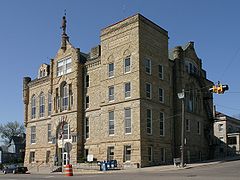
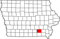
Location in the state of Iowa
Iowa's location in the U.S.Founded 1843 Seat Ottumwa Area
- Total
- Land
- Water
435.98 sq mi (1,129 km²)
431.81 sq mi (1,118 km²)
4.17 sq mi (11 km²), 0.96%Population
- (2010)
- Density
35,625
83/sq mi (32/km²)Time zone Central: UTC-6/-5 Website www.wapellocounty.org Footnotes: Population [1] Wapello County is a county located in the U.S. state of Iowa. The population was 35,625 in the 2010 census, a decline from 36,051 in the 2000 census.[1][2] The county seat is Ottumwa. [3]
Contents
Geography
According to the 2000 census, the county has a total area of 435.98 square miles (1,129.2 km2), of which 431.81 square miles (1,118.4 km2) (or 99.04%) is land and 4.17 square miles (10.8 km2) (or 0.96%) is water.[4]
Major highways
 U.S. Highway 34
 U.S. Highway 63
 Iowa Highway 16
 Iowa Highway 137
 Iowa Highway 149
Adjacent counties
- Mahaska County (northwest)
- Keokuk County (northeast)
- Jefferson County (east)
- Davis County (south)
- Monroe County (west)
History
 Chief Wapello; "Wa-pel-la the Prince, Musquakee Chief", painted by Charles Bird King.
Wapello County was formed on February 17, 1843. It was named for Wapello, a Meskwaki chief.[5]
Demographics
Historical populations Census Pop. %± 1850 8,471 — 1860 14,518 71.4% 1870 22,346 53.9% 1880 25,285 13.2% 1890 30,426 20.3% 1900 35,426 16.4% 1910 37,743 6.5% 1920 37,937 0.5% 1930 40,480 6.7% 1940 44,280 9.4% 1950 47,397 7.0% 1960 46,126 −2.7% 1970 42,149 −8.6% 1980 40,241 −4.5% 1990 35,696 −11.3% 2000 36,051 1.0% 2010 35,625 −1.2% Iowa Data Center [2] 2010 census
The 2010 census recorded a population of 35,625 in the county, with a population density of 82.5016/sq mi (31.8540/km2). There were 16,098 housing units, of which 14,552 were occupied.[1]
2000 census
 2000 Census Age Pyramid for Wapello County
As of the census[6] of 2000, there were 36,051 people, 14,784 households, and 9,801 families residing in the county. The population density was 84 people per square mile (32/km²). There were 15,873 housing units at an average density of 37 per square mile (14/km²). The racial makeup of the county was 96.28% White, 0.93% Black or African American, 0.28% Native American, 0.65% Asian, 0.02% Pacific Islander, 1.05% from other races, and 0.79% from two or more races. 2.22% of the population were Hispanic or Latino of any race.
There were 14,784 households out of which 28.80% had children under the age of 18 living with them, 52.70% were married couples living together, 9.90% had a female householder with no husband present, and 33.70% were non-families. 28.20% of all households were made up of individuals and 13.40% had someone living alone who was 65 years of age or older. The average household size was 2.37 and the average family size was 2.89.
In the county the population was spread out with 23.30% under the age of 18, 9.70% from 18 to 24, 26.00% from 25 to 44, 23.30% from 45 to 64, and 17.80% who were 65 years of age or older. The median age was 39 years. For every 100 females there were 94.80 males. For every 100 females age 18 and over, there were 91.70 males.
The median income for a household in the county was $32,188, and the median income for a family was $39,224. Males had a median income of $31,346 versus $21,286 for females. The per capita income for the county was $16,500. About 9.40% of families and 13.20% of the population were below the poverty line, including 18.00% of those under age 18 and 7.90% of those age 65 or over.
Communities
Cities
Unincorporated communities
- Ashland
- Bladensburg
- Dahlonega
- Pickwick
- Ottumwa Junction
- Rutledge
See also
- Wapello County Courthouse
- National Register of Historic Places listings in Wapello County, Iowa
References
- ^ a b c "Population & Housing Occupancy Status 2010". United States Census Bureau American FactFinder. http://factfinder2.census.gov/faces/tableservices/jsf/pages/productview.xhtml?pid=DEC_10_PL_GCTPL2.ST05&prodType=table. Retrieved 2011-06-11.
- ^ a b "Data from the 2010 Census". State Data Center of Iowa. http://www.iowadatacenter.org/archive/2011/02/feb10. Retrieved 2011-06-11.
- ^ "Find a County". National Association of Counties. http://www.naco.org/Counties/Pages/FindACounty.aspx. Retrieved 2011-06-07.
- ^ "Census 2000 U.S. Gazetteer Files: Counties". United States Census. http://www.census.gov/tiger/tms/gazetteer/county2k.txt. Retrieved 2011-02-13.
- ^ Wapello County
- ^ "American FactFinder". United States Census Bureau. http://factfinder.census.gov. Retrieved 2008-01-31.
External links

Mahaska County Keokuk County Monroe County 
Jefferson County  Wapello County, Iowa

Davis County Municipalities and communities of Wapello County, Iowa Cities Agency | Blakesburg | Chillicothe | Eddyville‡ | Eldon | Kirkville | Ottumwa

Unincorporated
communitiesBladensburg | Dudley | Farson
Footnotes ‡This populated place also has portions in an adjacent county or counties
Coordinates: 41°01′46″N 92°24′32″W / 41.02944°N 92.40889°W
Categories:- Iowa counties
- Wapello County, Iowa
- 1843 establishments in the United States
- Populated places established in 1843


Wikimedia Foundation. 2010.