- North Ryde, New South Wales
-
North Ryde
Sydney, New South Wales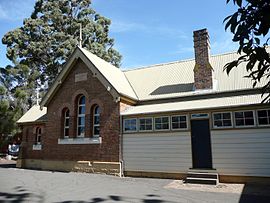
North Ryde Public School, established in 1877Population: 17,208 Postcode: 2113 Location: 15 km (9 mi) north-west of Sydney CBD LGA: City of Ryde State District: Ryde, Lane Cove Federal Division: Bennelong Suburbs around North Ryde: Marsfield Macquarie Park Chatswood West Eastwood North Ryde Lane Cove West Denistone East Ryde East Ryde North Ryde is a suburb of Sydney, in the state of New South Wales, Australia. North Ryde is located 15 kilometres north-west of the Sydney central business district, in the local government area of the City of Ryde. North Ryde is in the Northern Suburbs region of Sydney.
One of Australia's major business districts, North Ryde is home to many computer corporations such as Microsoft, Hewlett Packard, and Sun Microsystems. The suburb is the site of Macquarie University and its residents include those from the university academe and the research sector.
North Ryde shares the postcode of 2113 with adjacent suburbs Macquarie Park and East Ryde. These suburbs were once part of North Ryde and many businesses and residences in these suburbs still advertise their address as being in North Ryde. Adjacent Macquarie University was issued with its own postcode by Australia Post, 2109, in the late 1980s.
Contents
History
The earliest reference to the area being known as North Ryde appears to be after the district's first public school (which opened on 25 January 1876) changed its name from City View Public School to North Ryde Public School in 1877. North Ryde is an extension of the adjacent suburb of Ryde which was named after the 'Ryde Store', a business run by G.M. Pope. He adopted the name from his birthplace of Ryde on the Isle of Wight, UK.[1] Ryde was the name used from the 1840s and adopted as the name of the municipality in 1870.
Aboriginal culture
The whole area between Parramatta and Lane Cove Rivers was originally known by its Aboriginal name Wallumatta. The Aboriginal name survives in a local park, the Wallumatta Nature Reserve, located at the corner of Twin and Cressy roads, North Ryde. The reserve is one of the last remnants of the remaining 0.5% (as at 2007)[2] of original and endangered[3] turpentine-ironbark forests on Wianamatta shale soil in Sydney.[4] See Sydney Turpentine-Ironbark Forest.
European settlement
Ryde is the third oldest settlement in Australia, after Sydney and Parramatta. The area between Parramatta and Lane Cove Rivers was originally known by white settlers as the Field of Mars and then the Eastern Farms. North Ryde was established in the mid 19th century as a farming district, in what was a heavily vegetated area, next to the already established district of Ryde. The Field of Mars Common was considered dangerous, as escaped convicts and bushrangers were known to frequent the area.[5]
Coxs Road
North Ryde's main street is Coxs Road, which was originally sandstone-lined to make it easier to haul goods up from the wharf on the Lane Cove River to the top of the hill. Coxs Road was spelt with an apostrophe (Cox's) until recent times. The original North Ryde Post Office on Lane Cove Road was opened in 1885 and in 1908 was moved to Coxs Road, and has since relocated premises within the Coxs Road Shopping precinct at least six times. The North Ryde School of Arts and Literary Institute, built in 1901 on land donated by William Cox of Pomona, became the venue for the annual ball, community meetings, fetes, art exhibitions, dances and culture. Extensions were built in 1907 with the North Ryde Library Branch located here. The original building was demolished in 1980 and a new Community Centre, School of Arts and Library complex was built.[6]
Thompson's Shop (1904) in Coxs Road was the general store and post office for many years, and apart from the schoolhouse is the only remaining original building still standing from those early years. Three gas street lamps were installed in Coxs Road in the 1920s. One has been restored and is in front of the schoolhouse. The Coxs Road Shopping Centre was destroyed by a suspicious fire around 1990 and a new shopping mall was built with improved amenities.
Motorcycling
In 1928 the Chatswood Motorcycle Club built a course in the area now known as the Commandment Rock Picnic Area of Lane Cove National Park. The North Ryde circuit was an early version of off-road speedway. The first North Ryde meetings were held in May and October 1928. It was reported that the October meeting attracted 7000 spectators. The Commandment Rock course was closed and another circuit known as the North Ryde Speedway was developed on what is now part of North Ryde Golf Course (then known as Cox’s Paddock), opposite from the present day School of Arts in Coxs Road. The track was located in a natural amphitheatre giving spectators an excellent view of the events. A typical meeting comprised 30 events of ten laps each. It closed in about 1935 when the golf course development began and the Chatswood Club merged with Willoughby Motor Cycle Club.[7][8]
Post-war
North Ryde remained rural until after World War II when the state government purchased and subdivided much of the land for Defence Homes and public housing. The rapid development of North Ryde in the 1950s and 1960s saw many of the older dwellings and buildings demolished.
A migrant hostel was located on the south side of Blenheim Road. During WWII the 3rd Australian Ordnance Army Vehicle Park was located in North Ryde, bounded by Epping, Wicks, Coxs and Blenheim Roads.[9] Farming activity included orchards, market gardens and poultry. A pig farm was located in Wicks Road and was operational until the late 1960s. The House of David operated for many years on Lane Cove Road, and included a general store, picnic grounds, tennis courts, a miniature train ride, and a small zoo, later adding a VW car dealership to the complex. A Volkswagen car assembly plant was located behind the House of David in Waterloo Road before being moved to Mexico. The North Ryde Skyline Drive-In Theatre was opened in 1956 on the southern corner of Waterloo and Lane Cove Roads, adjoining the newly built North Ryde High School, and operated until the mid-1980s.[6]
Murders: Sef Gonzales
Main article: Sef GonzalesIn July 2001, Sef Gonzales murdered his entire family at their home on Collins Street, North Ryde. After being found guilty of the murders of his parents and sister in 2004 he was sentenced to life imprisonment at Goulburn Correctional Centre.
In addition, there have been several other horrendous murders in the North Ryde area. The "body in the bathroom" and others have horrified members of the community. [10]
Commercial areas
North Ryde features many commercial and industrial developments. The Coxs Road Shopping Centre is a small shopping mall that features a supermarket, the post office, and specialty shops. The Public School, Community Centre, Library and School of Arts are all located nearby. Another commercial development is located opposite featuring a number of cafes, and eateries. Another row of shops is located in Blenheim Road, including the Adwill Place Arcade.
The mid 1960s saw the combined establishment of the North Ryde Industrial Area and Macquarie University to emulate the industrial areas surrounding and associated with Stanford University near San Francisco, California[citation needed]. Industries were originally limited to being "light", science related, and include research activities. The area has seen massive growth since the 1960s with the precincts in Macquarie Park and the Riverside Corporate Park now having the reputation as the leading high-tech industrial areas in Australia, attracting major information technology, communication, electronic, computing, scientific, medical, and pharmaceutical companies [5].
The neighbouring suburb of Macquarie Park, still considered a part of North Ryde, includes the regional shopping centre Macquarie Centre, Macquarie University, ARN (WSFM and The Edge 96.1 studios), Sony, Foxtel, Optus, CA, Rexel Group Australia and many corporate headquarters.
Schools
The district's first public school, City View Public School, opened on 25 January 1876 but changed its name to North Ryde Public School in 1877, which is the earliest reference to the name North Ryde. It was originally called City View as the city of Sydney was visible from the roof. The original building in Coxs Road was a brick and sandstone building which now houses the NSW Schoolhouse Museum of Public Education. It is one of the oldest school buildings in New South Wales.[11]
A second primary school, Truscott Street Public School, opened on 21 May 1958; in 1988 the Truscott Street school incorporated a "Special Unit" for children with special needs.[12]
A large and modern senior school, North Ryde High School, was built on land between Epping and Waterloo Roads and opened in January 1962. It was later re-named Peter Board High School, which many residents felt took away its local identity. The school was subsequently phased out and closed in December 1998, demographics being used as justification for the decision. This move left North Ryde without a high school; Ryde Secondary College being the nearest alternative.[13]
A Catholic school, Holy Spirit Primary School, is located in Coxs Road, slightly further down from North Ryde Public School, on the opposite side of the road. Ryde East Primary School is located on Twin Road, with 350 students.
Arndell Special School is located in Badajoz Road on the Macquarie Hospital campus.
Hospitals
Macquarie Hospital
The Macquarie Hospital is bounded by Coxs, Wicks, Twin and Badajoz Roads. It was originally known as the North Ryde Mental Asylum but has undergone several other name changes from North Ryde Psychiatric Centre to Gladesville-Macquarie Hospital, following an amalgamation of services with Gladesville Hospital, and finally just Macquarie Hospital after Gladesville Hospital closed. It is an important 195 bed specialist mental health facility offering acute admission, non-acute recovery and extended care programs for adults with a mental illness/disorder who reside within the Northern Sydney Central Coast Health catchment area. The hospital works collaboratively with a range of community mental health and specialist non-government organisations and has a catchment population of approximately 1,110,000 residents. The hospital is gazetted under the New South Wales Mental Health Act 1990. Macquarie Hospital is involved in a major planning project to develop an evidence-based service model for the future delivery of mental health services involving Northern Sydney and Central Coast catchment areas for the next ten years. This includes the development of a Procurement Feasibility Plan for a proposed Psychiatric Intensive Care Unit which may be developed on the Macquarie campus. New Horizons Enterprises, part of the Macquarie Hospital North Ryde Auxiliary, operates an acute aged care facility in Badajoz Road, on the site of the former New Horizons Service Station, with sheltered workhops and Head Office in Twin Road. Arndell Special School (Disturbed Children's Ward) is located in the Macquarie Hospital campus, along with other specialist providers and an Education Centre for training and evaluation.[14]
There are no emergency services at Macquarie Hospital. The nearest Emergency Departments are at Ryde Hospital, Concord Hospital, or Royal North Shore Hospital.
Macquarie University Hospital
The Macquarie University Hospital, is a specialist private hospital that opened on 15 June 2010 located on the Campus of Macquarie University in Macquarie Park, North Ryde. It is now the primary teaching hospital affiliated with the University's Australian School of Advanced Medicine. The Hospital features some of the most advanced medical facilities in Australia, including the first gamma knife in Australia.[15]
There are no emergency services at Macquarie University Hospital. The nearest emergency departments are at Ryde Hospital, Concord Hospital. or Royal North Shore Hospital.
Transport
The M2 Hills Motorway passes through North Ryde en route to the Lane Cove Tunnel motorway, and then the Gore Hill/Warringah Freeway, Sydney Harbour Bridge, and Sydney CBD. Lane Cove Road (Metroad 3), traverses North Ryde from north to south, linking Sydney's North Shore to Homebush Bay and Sydney Olympic Park. Epping Road runs west to east and crosses the Lane Cove River Bridge to link the City of Ryde to the Municipality of Lane Cove. North Ryde is serviced by public buses, primarily the Routes 285-297, 506, and 534-535 which criss-cross the district. Private shuttle buses provide local and Airport services.
North Ryde railway station is an underground railway station on the Epping to Chatswood railway line that opened in 2009.[16] It is located close to the intersection of Epping Road and Delhi Road, near the M2 Motorway. During the steam era, there was a proposal to build a railway station in North Ryde near the intersection of Coxs Road and Wicks Road, but the Epping-St Leonards Railway was never built.
The intersection of Epping and Pittwater Road was once destined to be a major junction of part of "Sydney's Missing Roads" until the cancellation of the North Western and Lane Cove Valley Expressways in the late 1970s.[17] The Eastwood County Road (also referred to as Silverwater-North Ryde route or the Ermington-Epping Rd link) was also proposed, with the corridor remaining reserved today.[18]
The intersection of Epping Road and Lane Cove Road was originally planned to be Australia's first "clover leaf" intersection. Land on all four corner of the intersection had been acquired for the flyover loops. However, as construction of the Epping Road main bridge deck progressed, the loops were dropped, leaving it as a traffic light–controlled intersection under the overpass. The land on the four corners has since been re-utilised, one being a Medical Center, another an office building. This is now one of the most congested roads in Sydney.
Parks and reserves
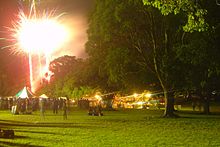 Fireworks at North Ryde Commons
North Ryde has many beautiful parks and reserves, including North Ryde Common, and the adjacent Lane Cove National Park, the Field of Mars Reserve, and access to the Great North Walk and the Lane Cove River, once home to the famous Fairyland picnic grounds, when boatloads of people would come up the river from Sydney for the regular Saturday Dances. Today very little remains of Fairyland and it is almost completely overgrown.
North Ryde Park received a major upgrade in 2009 with fully refurbished amenities block and a new children's play area.
Blenheim Park features an off-leash area for dogs.
Sport and recreation
- Macquarie University Theatre has winter programs of Classical Concerts and other performances. Classical concerts and such other performances are by invitation from the University Vice-Chancellor.
- North Ryde Golf Club is a par 69 golf course, which was previously a site for motorcycle racing in the late 1920s.
- North Ryde RSL Community Club
- Australia Day Concerts and Carols by Candlelight are held each year at North Ryde Common, adjacent to Macquarie Hospital. The grounds are open now after the removal of the original hospitals gates and fences, leased to Ryde Council for 99-years.
- Ryde Hunters Hill Hockey Club is on the grounds of the former Peter Board High School has over a 50 year history in the area poviding Field Hockey for Juniors, Women's and Men's.
Politics
North Ryde is in the State of New South Wales electorates of Lane Cove and Ryde, and the Federal electorate of Division of Bennelong.
See also
References
- ^ The Book of Sydney Suburbs, Compiled by Frances Pollon, Angus & Robertson Publishers, 1990, Published in Australia ISBN 0-207-14495-8, page 189
- ^ City of Ryde Council website, "NATIVE VEGETATION: Sydney Turpentine - Ironbark Forest", dated 1 January 2007. Accessed 1 July 2007.
- ^ National Parks and Wildlife Service (New South Wales) "Sydney turpentine-ironbark forest - endangered ecological community listing", 16 October 1998. Accessed 1 July 2007.
- ^ Wallumatta Nature Reserve National Parks and Wildlife Service(information page). Accessed 1 July 2007.
- ^ The Book of Sydney Suburbs, Compiled by Frances Pollen, Angus & Robertson Publishers, 1990, Published in Australia ISBN 0-207-14495-8
- ^ a b http://www.dictionaryofsydney.org/entry/north_ryde
- ^ http://trove.nla.gov.au/ndp/del/article/16632732?searchTerm=north ryde&searchLimits=
- ^ http://northern-district-times.whereilive.com.au/local-info/story/rev-heads-roar-across-north-ryde
- ^ http://cas.awm.gov.au/photograph/P00165.011
- ^ http://northern-district-times.whereilive.com.au/news/story/man-arrested-for-north-ryde-murder/
- ^ NSW Schoolhouse Museum of Public Education
- ^ Truscott Street Public School
- ^ Parliament of NSW - Legislative Council Hansard (Friday, 19 June 1998)
- ^ Macquarie Hospital
- ^ http://www.muh.org.au/news.html
- ^ City of Ryde 'Agenda of the Committee of the Whole', Meeting No. 11/08, dated 15 July 2008
- ^ OzRoads - Unbuilt NSW roads - Lane Cove Valley Expressway
- ^ OzRoads - Unbuilt NSW roads - Eastwood County Road
External links
- City of Ryde - Council site
- Sydney Turpentine-Ironbark Forest (Ryde Council website, with list of local endangered plant species that residents should give preference to when making new plantings in their gardens).
- North Ryde by Margaret Farlow
- North Ryde, New South Wales is at coordinates 33°47′33″S 151°07′10″E / 33.79242°S 151.11954°ECoordinates: 33°47′33″S 151°07′10″E / 33.79242°S 151.11954°E
Suburbs of the City of Ryde · Northern Suburbs · Sydney Denistone · Denistone East · Denistone West · East Ryde · Eastwood · Gladesville · Macquarie Park · Marsfield · Meadowbank · Melrose Park · North Ryde · Putney · Ryde · Tennyson Point · West Ryde
List of Sydney suburbs Categories:- Suburbs of Sydney


Wikimedia Foundation. 2010.