- Clarke County, Iowa
-
Clarke County, Iowa 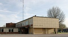 Clarke County Courthouse in Osceola
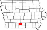
Location in the state of Iowa
Iowa's location in the U.S.Founded 1846 Seat Osceola Area
- Total
- Land
- Water
431.72 sq mi (1,118 km²)
431.12 sq mi (1,117 km²)
0.60 sq mi (2 km²), 0.14%Population
- (2010)
- Density
9,286
21.5/sq mi (8.3/km²)Time zone Central: UTC-6/-5 Website www.clarkecountyiowa.org Footnotes: Population [1] Clarke County is a county located in the U.S. state of Iowa. It is named in honor of James Clarke, who was appointed Governor of Iowa Territory in November 1845 and was the last Territorial Governor, since Iowa was admitted to the Union on December 28, 1846.The population was 9,286 in the 2010 census, an increase from 9,133 in 2000.[1][2] The county seat is Osceola.[3]
Contents
Geography
According to the 2000 census, the county has a total area of 431.72 square miles (1,118.1 km2), of which 431.12 square miles (1,116.6 km2) (or 99.86%) is land and 0.60 square miles (1.6 km2) (or 0.14%) is water.[4]
Major highways
 Interstate 35
 U.S. Highway 34
 U.S. Highway 69
 Iowa Highway 152
Adjacent counties
- Madison County (northwest)
- Warren County (northeast)
- Lucas County (east)
- Decatur County (south)
- Union County (west)
History
Clarke County was formed on January 13, 1846. It was named for James Clarke, a Governor of the Iowa Territory.[5]
Demographics
Historical populations Census Pop. %± 1850 79 — 1860 5,427 6,769.6% 1870 8,735 61.0% 1880 11,513 31.8% 1890 11,332 −1.6% 1900 12,440 9.8% 1910 10,736 −13.7% 1920 10,506 −2.1% 1930 10,384 −1.2% 1940 10,233 −1.5% 1950 9,369 −8.4% 1960 8,222 −12.2% 1970 7,581 −7.8% 1980 8,612 13.6% 1990 8,287 −3.8% 2000 9,133 10.2% 2010 9,286 1.7% Iowa Data Center [2] 2010 census
The 2010 census recorded a population of 9,286 in the county, with a population density of 21.545/sq mi (8.319/km2). There were 4,086 housing units, of which 3,701 were occupied.[1]
2000 census
 2000 Census Age Pyramid for Clarke County.
As of the census[6] of 2000, there were 9,133 people, 3,584 households, and 2,498 families residing in the county. The population density was 21 people per square mile (8/km²). There were 3,934 housing units at an average density of 9 per square mile (4/km²). The racial makeup of the county was 96.64% White, 0.11% Black or African American, 0.33% Native American, 0.35% Asian, 0.03% Pacific Islander, 1.96% from other races, and 0.58% from two or more races. 4.04% of the population were Hispanic or Latino of any race.
There were 3,584 households out of which 32.10% had children under the age of 18 living with them, 57.80% were married couples living together, 8.30% had a female householder with no husband present, and 30.30% were non-families. 25.90% of all households were made up of individuals and 13.30% had someone living alone who was 65 years of age or older. The average household size was 2.50 and the average family size was 3.01.
In the county the population was spread out with 26.30% under the age of 18, 7.60% from 18 to 24, 26.50% from 25 to 44, 22.50% from 45 to 64, and 17.10% who were 65 years of age or older. The median age was 39 years. For every 100 females there were 97.00 males. For every 100 females age 18 and over, there were 94.00 males.
The median income for a household in the county was $34,474, and the median income for a family was $42,171. Males had a median income of $29,648 versus $20,522 for females. The per capita income for the county was $16,409. About 6.20% of families and 8.50% of the population were below the poverty line, including 12.10% of those under age 18 and 7.70% of those age 65 or over.
Localities
Cities
Townships
See also
References
- ^ a b c "Population and Housing Occupancy Status: 2010 - State -- County". United States Census Bureau American FactFinder. http://factfinder2.census.gov/faces/tableservices/jsf/pages/productview.xhtml?pid=DEC_10_PL_GCTPL2.ST05&prodType=table. Retrieved March 9, 2011.
- ^ a b "Data from the 2010 Census". State Data Center of Iowa. http://www.iowadatacenter.org/archive/2011/02/feb10. Retrieved March 9, 2011.
- ^ "Find a County". National Association of Counties. http://www.naco.org/Counties/Pages/FindACounty.aspx. Retrieved 2011-06-07.
- ^ "Census 2000 U.S. Gazetteer Files: Counties". United States Census. http://www.census.gov/tiger/tms/gazetteer/county2k.txt. Retrieved 2011-02-13.
- ^ Clarke County
- ^ "American FactFinder". United States Census Bureau. http://factfinder.census.gov. Retrieved 2008-01-31.

Madison County Warren County Union County 
Lucas County  Clarke County, Iowa

Decatur County Municipalities and communities of Clarke County, Iowa Cities 
Townships Coordinates: 41°01′22″N 93°47′11″W / 41.02278°N 93.78639°W
Categories:- Iowa counties
- Clarke County, Iowa
- 1846 establishments in the United States


Wikimedia Foundation. 2010.