- Mollisols
-
Mollisol 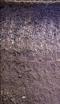
a Mollisol profile Used in: USDA soil taxonomy Parent material: loess Mollisols are a soil order in USDA soil taxonomy. Mollisols form in semi-arid to semi-humid areas, typically under a grassland cover. They are most commonly found in the mid-latitudes, namely in North America, mostly east of the Rocky Mountains, in South America in Argentina (Pampas) and Brazil, and in Asia in Mongolia and the Russian Steppes. Their parent material is typically base-rich and calcareous and include limestone, loess, or wind-blown sand. The main processes that lead to the formation of grassland Mollisols are melanisation, decomposition, humification and pedoturbation.
Mollisols have deep, high organic matter, nutrient-enriched surface soil (A horizon), typically between 60–80 cm in depth. This fertile surface horizon, known as a mollic epipedon, is the defining diagnostic feature of Mollisols. Mollic epipedons result from the long-term addition of organic materials derived from plant roots, and typically have soft, granular, soil structure.
Mollisols occur in savannahs and mountain valleys (such as Central Asia, or the North American Great Plains). These environments have historically been strongly influenced by fire and abundant pedoturbation from organisms such as ants and earth worms. It was estimated that in 2003, only 14 to 26 percent of grassland ecosystems still remained in a relatively natural state (that is, they weren't used for agriculture due to the fertility of the A horizon). Globally, they represent ~7% of ice-free land area. As the world's most agriculturally productive soil order, the Mollisols represent one of the more economically important soil orders.
Though most of the other soil orders known today existed by the time of the Carboniferous Ice Age 280 million years ago, Mollisols are not known from the paleopedological record any earlier than the Eocene. Their development is very closely associated with the cooling and drying of the global climate that occurred during the Oligocene, Miocene and Pliocene
Contents
Suborders
- Albolls — wet soils; aquic soil moisture regime with an eluvial horizon
- Aquolls — wet soils; aquic soil moisture regime
- Cryolls — cold climate; frigid or cryic soil temperature regime
- Gelolls — very cold climate; mean annual soil temperature <0°C
- Rendolls — lime parent material
- Udolls — humid climate; udic moisture regime
- Ustolls — subhumid climate; ustic moisture regime
- Xerolls — Mediteranaean climate; xeric moisture regime
Soils which are in most ways similar to Mollisols but contain either continuous or discontinuous permafrost and are consequently affected by cryoturbation are common in the high mountain plateaux of Tibet and the Andean altiplano. Such soils are known as Molliturbels or Mollorthels and provide the best grazing land in such cold climates because they are not acidic like many other soils of very cold climates.
Other soils which have a mollic epipedon are classified as Vertisols because the presence of high shrink swell characteristics and relatively high clay contents takes precedence over the mollic epipedon. These are especially common is parts of South America in the Paraná River basin that have abundant but erratic rainfall and extensive deposition of clay-rich minerals from the Andes. Mollic epipedons also occur in some Andisols but the andic properties take precedence.
See also
Pedogenesis
Pedology (soil study)
Soil classification
Soil science
Soil typeExternal links
- "Mollisols". USDA-NRCS. http://soils.usda.gov/technical/classification/orders/mollisols.html. Retrieved 2006-05-14.
- "Mollisols". University of Florida. http://grunwald.ifas.ufl.edu/Nat_resources/soil_orders/mollisols.htm. Retrieved 2006-05-14.
- "Mollisols". University of Idaho. http://soils.ag.uidaho.edu/soilorders/mollisols.htm. Retrieved 2006-05-14.
USDA Soil Taxonomy World Reference Base
for Soil ResourcesAcrisols · Albeluvisols · Alisols · Andosols · Anthrosols · Arenosols · Calcisols · Cambisols · Chernozem · Cryosols · Durisols · Ferralsols · Fluvisols · Gleysols · Gypsisols · Histosols · Kastanozems · Leptosols · Lixisols · Luvisols · Nitisols · Phaeozems · Planosols · Plinthosols · Podzols · Regosols · Solonchaks · Solonetz · Stagnosols · Technosols · Umbrisols · VertisolsReferences
Brady, N.C. and Weil, R.R. (1996). ‘The Nature and Properties of Soils.’ 11th edition. (Prentice Hall, New Jersey).
Buol, S.W., Southard, R.J., Graham, R.C., and McDaniel, P.A. (2003). ‘Soil Genesis and Classification.’ 5th edition. (Iowa State University Press - Blackwell, Ames.)Categories:- Pedology
- Types of soil

Wikimedia Foundation. 2010.