- Jennings County, Indiana
-
Jennings County, Indiana 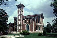 Jennings County courthouse in Vernon, Indiana
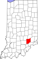
Location in the state of Indiana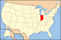
Indiana's location in the U.S.Founded 1817 Named for Jonathan Jennings Seat Vernon Area
- Total
- Land
- Water
378.34 sq mi (980 km²)
376.58 sq mi (975 km²)
1.76 sq mi (5 km²), 0.47%Population
- (2010)
- Density
28,525
76/sq mi (29.20/km²)Congressional district 9th Time zone Eastern: UTC-5/-4 Footnotes: Indiana county number 40
Jennings County is a county located in the U.S. state of Indiana. As of 2010, the population was 28,525.[1] The county seat is Vernon[2].
Contents
History
Jennings County was formed in 1817. It was named for the first Governor of Indiana and a nine term congressman, Jonathan Jennings. Jennings was governor when the county was organized.[3]
Geography
According to the 2010 census, the county has a total area of 378.34 square miles (979.9 km2), of which 376.58 square miles (975.3 km2) (or 99.53%) is land and 1.76 square miles (4.6 km2) (or 0.47%) is water.[4] It is a rural county, with majority of the county consisting of personal farms and woodlands. There are only two incorporated towns in this county, Vernon, the county seat, and North Vernon. Both are quite small and underdeveloped by urban standards; many locals prefer to do their shopping in neighboring counties. The county is conveniently located in the center of an imaginary triangle consisting of Indianapolis, IN, Cincinnati,OH, and Louisville, KY and requires only 1 1/4 hour drive time to any of these urban centers.
It is also home to the Muscatatuck Urban Training Center, located just outside North Vernon, at which various training exercises and scenarios are conducted for homeland security and other similar purposes.[5]
Cities and towns
Unincorporated towns
- Hayden
- Butlerville
- Nebraska
- Zenas
- Brewersville
- Lovett
- Commiskey
- Queensville
- Paris Crossing
- Paris
- San Jacinto
- Scipio
Townships
Adjacent counties
- Decatur County (north)
- Ripley County (east)
- Jefferson County (southeast)
- Scott County (south)
- Jackson County (west)
- Bartholomew County (northwest)
Major highways
Sources: National Atlas,[6] U.S. Census Bureau[7]
National protected areas
Climate and weather
Vernon, Indiana Climate chart (explanation) J F M A M J J A S O N D 338222.745263.855344.466434.775523.883614.486654.484632.978563.267443.854363.44327Average max. and min. temperatures in °F Precipitation totals in inches Source: The Weather Channel[8] Metric conversion J F M A M J J A S O N D 753-6697-3961311111961202411972816112301811229177326138119797122866-3Average max. and min. temperatures in °C Precipitation totals in mm In recent years, average temperatures in Vernon have ranged from a low of 22 °F (−6 °C) in January to a high of 86 °F (30 °C) in July, although a record low of −24 °F (−31 °C) was recorded in January 1977 and a record high of 105 °F (41 °C) was recorded in July 1954. Average monthly precipitation ranged from 2.71 inches (69 mm) in February to 4.72 inches (120 mm) in May.[8]
Government
See also: Government of IndianaThe county government is a constitutional body, and is granted specific powers by the Constitution of Indiana, and by the Indiana Code.
County Council: The county council is the legislative branch of the county government and controls all the spending and revenue collection in the county. Representatives are elected from county districts. The council members serve four year terms. They are responsible for setting salaries, the annual budget, and special spending. The council also has limited authority to impose local taxes, in the form of an income and property tax that is subject to state level approval, excise taxes, and service taxes.[9][10]
Board of Commissioners: The executive body of the county is made of a board of commissioners. The commissioners are elected county-wide, in staggered terms, and each serves a four-year term. One of the commissioners, typically the most senior, serves as president. The commissioners are charged with executing the acts legislated by the council, collecting revenue, and managing the day-to-day functions of the county government.[9][10]
Court: The county maintains a small claims court that can handle some civil cases. The judge on the court is elected to a term of four years and must be a member of the Indiana Bar Association. The judge is assisted by a constable who is also elected to a four-year term. In some cases, court decisions can be appealed to the state level circuit court.[10]
County Officials: The county has several other elected offices, including sheriff, coroner, auditor, treasurer, recorder, surveyor, and circuit court clerk Each of these elected officers serves a term of four years and oversees a different part of county government. Members elected to county government positions are required to declare party affiliations and to be residents of the county.[10]
Jennings County is part of Indiana's 9th congressional district and is represented in Congress by Democrat Baron Hill.[11] It is also part of Indiana Senate districts 43 and 45[12] and Indiana House of Representatives districts 66 and 69.[13]
Demographics
Historical populations Census Pop. %± 1820 2,000 — 1830 3,974 98.7% 1840 8,829 122.2% 1850 12,096 37.0% 1860 14,749 21.9% 1870 16,218 10.0% 1880 16,453 1.4% 1890 14,608 −11.2% 1900 15,757 7.9% 1910 14,203 −9.9% 1920 13,280 −6.5% 1930 11,800 −11.1% 1940 13,680 15.9% 1950 15,250 11.5% 1960 17,267 13.2% 1970 19,454 12.7% 1980 22,854 17.5% 1990 23,661 3.5% 2000 27,554 16.5% 2010 28,525 3.5% Sources: United States Department of Commerce,
Bureau of the Census, Population Division[14]
Census Quickfacts[1]As of the census[15] of 2000, there were 27,554 people, 10,134 households, and 7,600 families residing in the county. The population density was 73 people per square mile (28/km²). There were 11,469 housing units at an average density of 30 per square mile (12/km²). The racial makeup of the county was 97.45% White, 0.75% Black or African American, 0.21% Native American, 0.26% Asian, 0.21% from other races, and 1.11% from two or more races. 0.70% of the population were Hispanic or Latino of any race. 32.1% were of American, 24.7% German, 10.9% English and 10.0% Irish ancestry according to Census 2000.
There were 10,134 households out of which 36.40% had children under the age of 18 living with them, 60.70% were married couples living together, 9.50% had a female householder with no husband present, and 25.00% were non-families. 20.60% of all households were made up of individuals and 8.20% had someone living alone who was 65 years of age or older. The average household size was 2.67 and the average family size was 3.07.
In the county the population was spread out with 27.70% under the age of 18, 8.20% from 18 to 24, 30.40% from 25 to 44, 23.00% from 45 to 64, and 10.70% who were 65 years of age or older. The median age was 35 years. For every 100 females there were 98.80 males. For every 100 females age 18 and over, there were 96.90 males.
The median income for a household in the county was $39,402, and the median income for a family was $42,519. Males had a median income of $30,377 versus $21,023 for females. The per capita income for the county was $17,059. About 6.00% of families and 9.20% of the population were below the poverty line, including 10.00% of those under age 18 and 11.80% of those age 65 or over.
Notable residents
- Lincoln Dixon, U.S. Representative from Indiana, 1905–1919
- Jeptha D. New, U.S. Representative from Indiana, 1875–1877, 1879–1881
- Hannah Milhous Nixon, mother of President Richard Nixon
- Pat O'Connor, polesitter for the 1957 Indianapolis 500 and member of the National Sprint Car Hall of Fame
- Jessamym West, author of The Friendly Persuasion
- Albert Edward Wiggam, psychologist, lecturer, and author
- Edgar Whitcomb, 43rd Governor of Indiana
References
- ^ a b "Jennings County QuickFacts". United States Census Bureau. http://quickfacts.census.gov/qfd/states/18/18079.html. Retrieved 2011-09-25.
- ^ "Find a County". National Association of Counties. http://www.naco.org/Counties/Pages/FindACounty.aspx. Retrieved 2011-06-07.
- ^ De Witt Clinton Goodrich & Charles Richard Tuttle (1875). An Illustrated History of the State of Indiana. Indiana: R. S. Peale & co.. pp. 563. http://books.google.com/books?id=YDIUAAAAYAAJ.
- ^ "Census 2010 U.S. Gazetteer Files: Counties". United States Census. http://www.census.gov/geo/www/gazetteer/files/Gaz_counties_national.txt. Retrieved 2011-10-10.
- ^ "Muscatatuck Urban Training Center". United States Department of Defense. http://www.mutc.org/. Retrieved 2007-10-05.
- ^ National Atlas
- ^ U.S. Census Bureau TIGER shape files
- ^ a b "Monthly Averages for Vernon, Indiana". The Weather Channel. http://www.weather.com/weather/wxclimatology/monthly/graph/USIN0684. Retrieved 2011-01-27.
- ^ a b Indiana Code. "Title 36, Article 2, Section 3". IN.gov. http://www.in.gov/legislative/ic/code/title36/ar2/ch3.html. Retrieved 2008-09-16.
- ^ a b c d Indiana Code. "Title 2, Article 10, Section 2". IN.gov. http://www.in.gov/legislative/ic/code/title3/ar10/ch2.pdf. Retrieved 2008-09-16.
- ^ "Conressman Baron Hill". House.Gov. http://baronhill.house.gov/district.shtml. Retrieved 2008-09-12.
- ^ "Indiana Senate Districts". State of Indiana. http://www.in.gov/sos/elections/3006.htm. Retrieved 2011-07-14.
- ^ "Indiana House Districts". State of Indiana. http://www.in.gov/sos/elections/3005.htm. Retrieved 2011-07-14.
- ^ Forstall, Richard L. (editor) (1996). Population of states and counties of the United States: 1790 to 1990 : from the twenty-one decennial censuses. United States Department of Commerce, Bureau of the Census, Population Division. pp. 50–53. ISBN 0-934213-48-8. http://books.google.com/books?id=Z12v1lrkv2IC&lpg=PA50&pg=PA50#v=onepage&q&f=false.
- ^ "American FactFinder". United States Census Bureau. http://factfinder.census.gov. Retrieved 2008-01-31.
See also
- National Register of Historic Places listings in Jennings County, Indiana
- USS Jennings County (LST-846)

Bartholomew County Decatur County Jackson County 
Ripley County  Jennings County, Indiana

Scott County Jefferson County Municipalities and communities of Jennings County, Indiana City 
Town Townships Unincorporated
communitiesBrewersville | Butlerville | Commiskey | Four Corners | Grayford | Hayden | Hilltown | Lovett | Nebraska | Paris | Paris Crossing | Queensville | San Jacinto | Scipio | Walnut Ridge | Zenas
Categories:- Indiana counties
- Jennings County, Indiana
- 1817 establishments in the United States
- Populated places established in 1817


Wikimedia Foundation. 2010.