- Morgan County, Illinois
-
Morgan County, Illinois 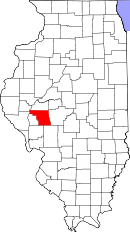
Location in the state of Illinois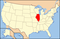
Illinois's location in the U.S.Founded 1823 Seat Jacksonville Largest city Jacksonville Area
- Total
- Land
- Water
572.30 sq mi (1,482 km²)
568.79 sq mi (1,473 km²)
3.51 sq mi (9 km²), 0.61%Population
- (2010)
- Density
35,547
64/sq mi (25/km²)Time zone Central: UTC-6/-5 Morgan County is a county located in the U.S. state of Illinois. According to the 2010 census, it has a population of 35,547, which is a decrease of 2.9% from 36,616 in 2000.[1] Its county seat is Jacksonville.[2]
Morgan County is part of the Jacksonville Micropolitan Statistical Area.
Contents
Geography
According to the 2010 census, the county has a total area of 572.30 square miles (1,482.3 km2), of which 568.79 square miles (1,473.2 km2) (or 99.39%) is land and 3.51 square miles (9.1 km2) (or 0.61%) is water.[3]
Major highways
 Interstate 72
 U.S. Highway 36
 U.S. Highway 67
 Illinois Route 123
 Illinois Route 78
 Illinois Route 100
 Illinois Route 104
 Illinois Route 267
Adjacent counties
- Cass County - north
- Sangamon County - east
- Macoupin County - southeast
- Greene County - south
- Pike County - west
- Scott County - west
- Brown County - northwest
National protected area
History
Morgan County was formed in 1823 out of Greene and Sangamon Counties. It was named in honor of General Daniel Morgan, who defeated the British at the Battle of Cowpens in the Revolutionary War. General Morgan was serving under General Nathanael Greene at Cowpens.
-

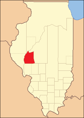
Morgan County from the time of its creation to 1837
-

Morgan County between 1837 and 1839, when Scott County was splitt off
-

Morgan County between 1839 and 1845
-

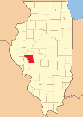
Morgan County in 1845, when its border with Cass County was moved southward, bringing both to their present borders
Demographics
Historical populations Census Pop. %± 1900 35,006 — 1910 34,420 −1.7% 1920 33,567 −2.5% 1930 34,240 2.0% 1940 36,378 6.2% 1950 35,568 −2.2% 1960 36,571 2.8% 1970 36,174 −1.1% 1980 37,502 3.7% 1990 36,397 −2.9% 2000 36,616 0.6% IL Counties 1900-1990 As of the census[4] of 2000, there were 36,616 people, 14,039 households, and 9,251 families residing in the county. The population density was 64 people per square mile (25/km²). There were 15,291 housing units at an average density of 27 per square mile (10/km²). The racial makeup of the county was 92.34% White, 5.36% Black or African American, 0.18% Native American, 0.46% Asian, 0.01% Pacific Islander, 0.70% from other races, and 0.95% from two or more races. 1.35% of the population were Hispanic or Latino of any race. 25.3% were of German, 17.3% American, 16.5% English and 10.3% Irish ancestry according to Census 2000.
There were 14,039 households out of which 30.00% had children under the age of 18 living with them, 52.70% were married couples living together, 10.00% had a female householder with no husband present, and 34.10% were non-families. 29.30% of all households were made up of individuals and 13.10% had someone living alone who was 65 years of age or older. The average household size was 2.37 and the average family size was 2.92.
In the county the population was spread out with 22.80% under the age of 18, 11.10% from 18 to 24, 27.20% from 25 to 44, 23.30% from 45 to 64, and 15.60% who were 65 years of age or older. The median age was 38 years. For every 100 females there were 98.60 males. For every 100 females age 18 and over, there were 97.00 males.
The median income for a household in the county was $36,933, and the median income for a family was $46,040. Males had a median income of $31,218 versus $23,174 for females. The per capita income for the county was $18,205. About 6.00% of families and 9.70% of the population were below the poverty line, including 10.60% of those under age 18 and 8.30% of those age 65 or over.
Cities and towns
- Bethel
- Chapin
- Concord
- Franklin
- Jacksonville
- Lynnville
- Meredosia
- Murrayville
- Orleans
- Prentice
- South Jacksonville
- Waverly
- Woodson
Unincorporated communities
- Alexander
- Arcadia
- Arnold
- Clements
- Literberry
- Merritt
- Nortonville
- Pisgah
- Rees
- Sinclair
Climate and weather
Jacksonville, Illinois Climate chart (explanation) J F M A M J J A S O N D 1.434151.740193.252293.864394.974494.483593.987633.485603.579522.668413.552312.53920Average max. and min. temperatures in °F Precipitation totals in inches Source: The Weather Channel[5] Metric conversion J F M A M J J A S O N D 341-9434-78111-2961841232391112815983117852916882611662058811-1654-7Average max. and min. temperatures in °C Precipitation totals in mm In recent years, average temperatures in the county seat of Jacksonville have ranged from a low of 15 °F (−9 °C) in January to a high of 87 °F (31 °C) in July, although a record low of −28 °F (−33 °C) was recorded in February 1934 and a record high of 114 °F (46 °C) was recorded in July 1954. Average monthly precipitation ranged from 1.35 inches (34 mm) in January to 4.86 inches (123 mm) in May.[5]
See also
References
- ^ "Morgan County QuickFacts". United States Census Bureau. http://quickfacts.census.gov/qfd/states/17/17137.html. Retrieved 2011-11-05.
- ^ "Find a County". National Association of Counties. http://www.naco.org/Counties/Pages/FindACounty.aspx. Retrieved 2011-06-07.
- ^ "Census 2010 U.S. Gazetteer Files: Counties". United States Census. http://www.census.gov/geo/www/gazetteer/files/Gaz_counties_national.txt. Retrieved 2011-11-05.
- ^ "American FactFinder". United States Census Bureau. http://factfinder.census.gov. Retrieved 2008-01-31.
- ^ a b "Monthly Averages for Jacksonville, Illinois". The Weather Channel. http://www.weather.com/weather/wxclimatology/monthly/graph/USIL0585. Retrieved 2011-01-27.

Brown County Cass County Pike County and Scott County 
Sangamon County  Morgan County, Illinois

Greene County Macoupin County Municipalities and communities of Morgan County, Illinois Cities 
Towns Villages Chapin | Concord | Franklin | Lynnville | Meredosia | Murrayville | South Jacksonville | Woodson
Precincts Alexander | Arcadia | Chapin | Concord | Franklin | Jacksonville No. 1 | Jacksonville No. 2 | Jacksonville No. 3 | Jacksonville No. 4 | Jacksonville No. 5 | Jacksonville No. 6 | Jacksonville No. 7 | Jacksonville No. 8 | Jacksonville No. 9 | Jacksonville No. 10 | Jacksonville No. 11 | Jacksonville No. 12 | Jacksonville No. 13 | Jacksonville No. 14 | Jacksonville No. 15 | Jacksonville No. 16 | Jacksonville No. 17 | Jacksonville No. 18 | Literberry | Lynnville | Markham | Meredosia No. 1 | Meredosia No. 2 | Murrayville No. 1 | Nortonville | Pisgah | Prentice-Sinclair | South Jacksonville No. 1 | South Jacksonville No. 2 | South Jacksonville No. 3 | South Jacksonville No. 4 | Waverly No. 1 | Waverly No. 2 | Waverly No. 3 | Woodson
Unincorporated
communitiesAlexander | Arcadia | Arnold | Clements | Literberry | Merritt | Nortonville | Pisgah | Rees | Sinclair
Categories:- Illinois counties
- 1823 establishments in the United States
- Populated places established in 1823
- Morgan County, Illinois
- Jacksonville, Illinois micropolitan area


Wikimedia Foundation. 2010.