- Chulmleigh
-
Coordinates: 50°54′46″N 3°52′09″W / 50.912778°N 3.869167°W
Chulmleigh 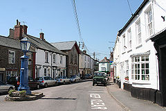
Main street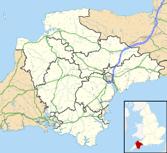
 Chulmleigh
Chulmleigh shown within DevonPopulation 1,308 (2001) OS grid reference SS6814 Parish Chulmleigh District North Devon Shire county Devon Region South West Country England Sovereign state United Kingdom Post town CHULMLEIGH Postcode district EX18 Dialling code 01769 Police Devon and Cornwall Fire Devon and Somerset Ambulance South Western EU Parliament South West England UK Parliament North Devon List of places: UK • England • Devon Chulmleigh (pronounced /ˈtʃʌmli/ Chum-lee) is a remote, Saxon hilltop town and civil parish located in North Devon in the heart of the English county of Devon. It is located 20 miles (32 km) north west of Exeter, just north of the Mid Devon boundary, linked by the A377 and B3096 roads. In 2001 the population of the parish was 1,308.[1]
Chulmleigh has some very old architecture with many cob and thatched buildings. It is located close to the Tarka Railway Line and King's Nympton Railway Station is within the parish, although it is around 2 miles (3.2 km) from the town.
Chulmleigh has a retained[2] Fire station which is part of Devon and Somerset Fire and Rescue Service. The secondary school is the Chulmleigh Community College[3] has been amongst Devon's highest GCSE league tables. The town's pub is the Old Court House.[4] on South Molton Street. The parish church is St Mary Magdalene.[5]
There are many local businesses and organisations, including Chulmleigh Cricket Club and Chulmleigh Golf Course.
References
- ^ "Parish Headcounts: North Devon". Office for National Statistics : Census 2001. http://www.neighbourhood.statistics.gov.uk/dissemination/viewFullDataset.do?instanceSelection=03070&productId=779&$ph=60_61&datasetInstanceId=3070&startColumn=1&numberOfColumns=8&containerAreaId=790362. Retrieved 27 January 2010.
- ^ "SS6814: Chulmleigh Fire Station". geograph.org.uk. http://www.geograph.org.uk/photo/68002. Retrieved 28 November 2010.
- ^ "Chulmleigh Community College". chulmeigh.devon.sch.uk. http://www.chulmleigh.devon.sch.uk.
- ^ "Old Court House". oldcourthouseinn.co.uk. http://www.oldcourthouseinn.co.uk.
- ^ "St Mary Magdalene". geograph.org.uk. http://www.geograph.org.uk/photo/356723.
External links
Categories:- Towns in Devon
- Devon geography stubs


Wikimedia Foundation. 2010.