- Coweta County, Georgia
-
Coweta County, Georgia 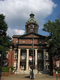 Coweta County Courthouse in Newnan, Georgia
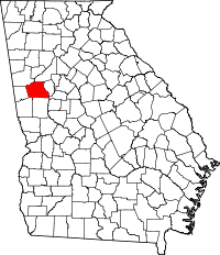
Location in the state of Georgia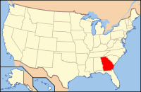
Georgia's location in the U.S.Founded 1826 Seat Newnan Largest city Newnan Area
- Total
- Land
- Water
445.98 sq mi (1,155 km²)
442.62 sq mi (1,146 km²)
3.36 sq mi (9 km²), 0.75%PopulationEst.
- (2006)
- Density
115,291
202/sq mi (78/km²)Time zone Eastern: UTC-5/-4 Website www.coweta.ga.us Coweta County is a county located in the U.S. state of Georgia. As of 2000, the population was 89,215. The 2009 Census Estimate placed the population at 131,936.[1] The county seat is Newnan.[2]
Coweta County is included in the Atlanta-Sandy Springs-Marietta, Georgia, Metropolitan Statistical Area.
Contents
History
The land for Lee, Muscogee, Troup, Coweta, and Carroll counties was ceded by the Creek people in the 1825 Treaty of Indian Springs. The counties' boundaries were created by the Georgia General Assembly on June 9, 1826, but they were not named until December 14, 1826. Coweta County was named for the Koweta Indians (a sub-group of the Creek people), who had several towns in and around present day Coweta.
Government and politics
The legislative body of Coweta County is the Coweta County Commission. The commission consists of five members elected from numbered districts. The commission chairmanship rotates among the members, Coweta County is the only in Georgia that operates with a rotating chairmanship. the current commissioners are:
District Commissioner Party Term of Office Seat Up 1st. Paul Poole Republican 2005–present 2012 2nd. Tim Lassiter Republican 2007–present 2010 3rd. Bob Blackburn Republican 2011–present 2011 4th. Rodney Brooks (chairman) Republican 2009–present 2012 5th. Al Smith Democrat 2009–present 2012 Geography
According to the 2000 census, the county has a total area of 445.98 square miles (1,155.1 km2), of which 442.62 square miles (1,146.4 km2) (or 99.25%) is land and 3.36 square miles (8.7 km2) (or 0.75%) is water.[3]
Major highways
 Interstate 85
 U.S. Route 27 Alternate
 U.S. Route 29
 State Route 14
 State Route 16
 State Route 34
 State Route 34 Bypass
 State Route 41
 State Route 54
 State Route 154
 State Route 70
 State Route 74
Adjacent counties
- Fulton County, Georgia – northeast
- Fayette County, Georgia – east
- Spalding County, Georgia – southeast
- Meriwether County, Georgia – south
- Troup County, Georgia – southwest
- Heard County, Georgia – west
- Carroll County, Georgia – northwest
Demographics
As of the census[4] of 2000, there were 89,215 people, 31,442 households, and 24,713 families residing in the county. The population density was 202 people per square mile (78/km²). There were 33,182 housing units at an average density of 75 per square mile (29/km²). The racial makeup of the county was 78.86% White, 17.97% Black or African American, 0.23% Native American, 0.68% Asian, 0.01% Pacific Islander, 1.22% from other races, and 1.02% from two or more races. 3.14% of the population were Hispanic or Latino of any race.
There were 31,442 households out of which 39.90% had children under the age of 18 living with them, 62.50% were married couples living together, 12.20% had a female householder with no husband present, and 21.40% were non-families. 17.60% of all households were made up of individuals and 5.70% had someone living alone who was 65 years of age or older. The average household size was 2.81 and the average family size was 3.17.
In the county the population was spread out with 28.70% under the age of 18, 7.60% from 18 to 24, 33.40% from 25 to 44, 21.80% from 45 to 64, and 8.50% who were 65 years of age or older. The median age was 34 years. For every 100 females there were 98.00 males. For every 100 females age 18 and over, there were 95.40 males.
The median income for a household in the county was $52,706, and the median income for a family was $58,750. Males had a median income of $41,369 versus $27,322 for females. The per capita income for the county was $21,949. About 6.10% of families and 7.80% of the population were below the poverty line, including 9.60% of those under age 18 and 10.50% of those age 65 or over.
Education
Main article: Newnan, Georgia#EducationNotable residents
- Ellis Gibbs Arnall, Georgia governor from 1943–1947.
- William Yates Atkinson, Georgia governor from 1894–1896. Founded Georgia State College for Women, now Georgia College & State University.
- Margaret Anne Barnes, author, best known for her book Murder in Coweta County, which was later made into a television movie starring Andy Griffith and Johnny Cash.
- Steve Bedrosian, Former Major League Baseball player and 1987 National League Cy Young Award winner.
- Buford Boone, publisher and writer; awarded the Pulitzer Prize in 1956.
- Keith Brooking, played for the Atlanta Falcons, now plays for Dallas Cowboys.
- Erskine Caldwell, author of Tobacco Road and God's Little Acre.
- Lewis Grizzard, newspaper columnist, author, and humorist.
- Sam Hose, an African American worker who was brutally tortured and executed by a lynch mob in Coweta County, Georgia on April 23, 1899.
- Drew Hill, played for the Houston Oilers, Los Angeles Rams, and Atlanta Falcons.
- Alan Jackson, country singer and musician.
- Joe M. Jackson, Colonel, USAF, Congressional Medal of Honor recipient.
- Warren Newson, played for the Chicago White Sox of the American League.
- Stephen W. Pless, Major, USMC, Congressional Medal of Honor recipient.
- Lamar Potts, Sr., Coweta County sheriff who brought John Wallace to justice for the 1948 murder of William Turner chronicled by Margaret Anne Barnes in Murder in Coweta County.
- Doug Stone, singer.
- Jefferson Randolph "Soapy" Smith (1860–1898), confidence man and crime boss.
- Charles Wadsworth, retired director of the Chamber Music Society at the Lincoln Center for the Performing Arts.
- Jerome Walton, Former Major League Baseball player and 1989 Major League Baseball Rookie of the Year Award winner in the National League.
Cities and towns
- Corinth (Unincorporated)
- East Newnan (CDP)
- Grantville
- Haralson
- Moreland
- Newnan
- Palmetto
- Sargent
- Senoia
- Sharpsburg
- Turin
- Raymond
- Roscoe
See also
References
- ^ http://www.census.gov/popest/counties/tables/CO-EST2007-01-13.xls
- ^ "Find a County". National Association of Counties. http://www.naco.org/Counties/Pages/FindACounty.aspx. Retrieved 2011-06-07.
- ^ "Census 2000 U.S. Gazetteer Files: Counties". United States Census. http://www.census.gov/tiger/tms/gazetteer/county2k.txt. Retrieved 2011-02-13.
- ^ "American FactFinder". United States Census Bureau. http://factfinder.census.gov. Retrieved 2008-01-31.
External links
- http://www.coweta.ga.us/
- http://www.rootsweb.com/~gacoweta/
- One of the Coweta websites for family history
- A Coweta website for the African American Heritage Museum News
- Fox 5 Hot List for CCAAHRC
- A church and cemetery website for Coweta and surrounding Counties

Carroll County Fulton County Heard County 
Fayette County  Coweta County, Georgia

Troup County Meriwether County Spalding County Municipalities and communities of Coweta County, Georgia County seat: Newnan Cities Grantville | Newnan | Palmetto‡ | Senoia

Towns Corinth‡ | Haralson‡ | Moreland | Sharpsburg | Turin
CDP Unincorporated
communityFootnotes ‡This populated place also has portions in an adjacent county or counties
Metro Atlanta Counties 
Major city Municipalities & communities 100k-250k 25k-100k Alpharetta • Brookhaven • Candler-McAfee • Duluth • Dunwoody • East Point • Gainesville • Johns Creek • Lawrenceville • Mableton • Marietta • Milton • Newnan • Peachtree City • Peachtree Corners • Redan • Smyrna • Tucker10k-25k Acworth • Belvedere Park • Buford • Carrollton • Cartersville • Chamblee • College Park • Conyers • Covington • Decatur • Doraville • Druid Hills • Douglasville • Fayetteville • Forest Park • Griffin • Kennesaw • Suwanee • Lilburn • Monroe • Mountain Park • North Decatur • North Druid Hills • Panthersville • Powder Springs • Riverdale • Snellville • Stockbridge • Sugar Hill • Union City • Vinings • Winder • WoodstockTopics Architecture • Culture • History • Media • Neighborhoods • People • Tourism • Transportation Georgia ·  United StatesCategories:
- Georgia (U.S. state) counties
- Atlanta metropolitan area
- Coweta County, Georgia
- 1826 establishments in the United States
- Populated places established in 1826


Wikimedia Foundation. 2010.