- Florida State Road A1A
-
"A1A" redirects here. For other uses, see A1A (disambiguation)."Ocean Boulevard" redirects here. For the road in Myrtle Beach, South Carolina, see South Carolina Highway 73.
State Road A1A
Route information Maintained by FDOT Length: 328.92 mi[1] (529.35 km) Existed: 1945 renumbering (definition) – present Major junctions South end: Bertha Street in Key West  I-595 in Dania Beach
 US 192 in Indialantic
 US 92 in Daytona Beach
 SR 202 in Jacksonville Beach
 US 17 in Yulee
 I-95 in Yulee
North end: 


 US 1 / US 23 / US 301 / SR 200 in Callahan
Location Counties: Monroe, Miami-Dade, Broward, Palm Beach, Martin, St. Lucie, Indian River, Brevard, Volusia, Flagler, St. Johns, Duval, Nassau Highway system Florida State and County Roads
Interstate • US • SR (Pre-1945) • Toll • County← US 1SR 2  →
→State Road A1A is a Florida State Road that runs mostly along the Atlantic Ocean, with sections from Key West at the southern tip of Florida, to Callahan, just south of Georgia. It is the main road through most oceanfront towns. SR A1A is designated the A1A Scenic and Historic Coastal Highway, a National Scenic Byway. It is also called the Indian River Lagoon Scenic Highway from Wabasso Causeway to U.S. Route 1 in Cocoa. In Key West it is also called South Roosevelt Boulevard. In Miami, it begins at MacArthur Causeway before becoming Collins Avenue at Fifth Street in Miami Beach (or, in small segments, Harding Avenue, Abbott Avenue, or Indian Creek Drive). In the town of Surfside, the northbound is Collins Avenue, and the southbound is Harding Avenue. In Bal Harbour it is called Bal Harbour Boulevard. In Golden Beach it is called Ocean Boulevard.
The designation is unique: other than Alternate SR A1A (now SR 811, SR 707, SR 732, and an extension of SR 842), only two other Florida State Roads have begun with a letter: SR A19A (now a loop of SR 693-SR 699-SR 682 near St. Petersburg), and SR G1A (now SR 300) have existed.
The road was assigned the number SR 1 in the 1945 renumbering as the easternmost major north–south road. However, tourists and residents confused the road with the parallel U.S. Route 1, so the name was changed to SR A1A, which stands for "Atlantic 1 Alternate".[2] The State Road Board changed the designation to SR A1A on November 25, 1946, about a year and a half after the renumbering.[3] SR A1A is signed north–south.
Contents
Route description
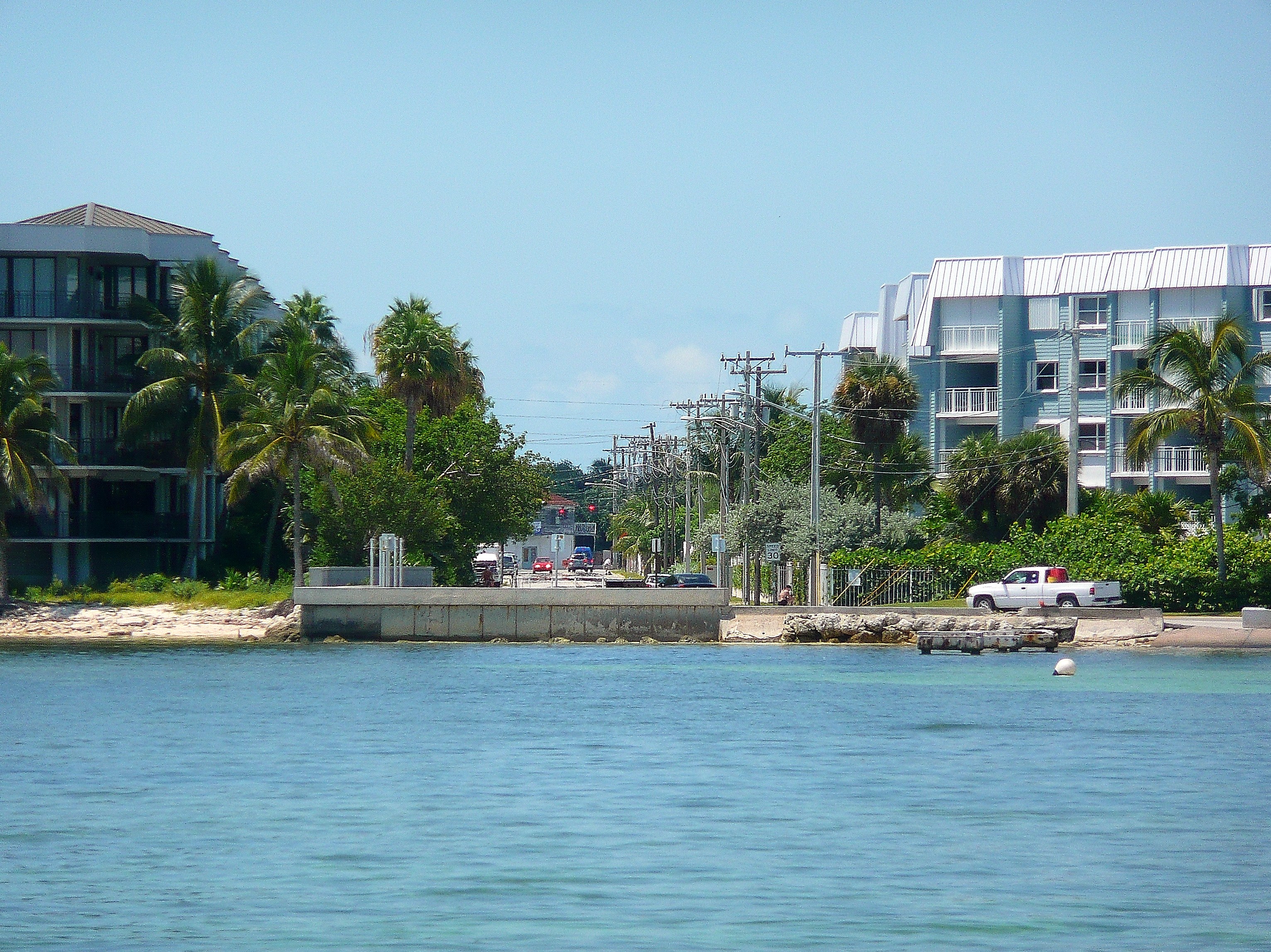
 The beginning of A1A (mile marker 0) at Bertha Street in Key West

 Scenic stretch of A1A in Flagler Beach
SR A1A is heavily associated with Florida beach culture and is known for its lush tropical and subtropical scenery and ocean vistas. In many places, the highway directly fronts the Atlantic Ocean, and in other places, runs 1-5 blocks inland from the beachfront. For most of its length, A1A runs along Florida's East Coast Barrier Islands, separated from the mainland of the state by the Intracoastal Waterway. Because of the road's proximity to the ocean and its susceptibility to storm surges, sections of A1A are often closed or even damaged by hurricanes and tropical storms. North of Atlantic Beach, however, A1A turns inland for several blocks before resuming a northward course that ends at the St. John's River. A ferry takes vehicular traffic to the northern section of A1A which continues inland toward Callahan.
A1A also has been a backbone of Florida Spring Break, serving as "the strip" in both Fort Lauderdale, a popular spring break destination in the 60s, 70s, and 80s, as well as Daytona Beach, which became a popular destination for college spring breakers in the 80s through the present. In Miami Beach, A1A serves as Collins Avenue, one of the city's main north–south thoroughfares, and travels a similar route through exclusive Palm Beach, further to the north. In the Vero Beach area, it is known as The Robert C. Spillman Memorial Highway and it bridges Sebastian Inlet at the Sebastian Inlet Bridge. It then passes just to the west of Cape Canaveral and the Kennedy Space Center. Two miles of A1A were used as part of the legendary Daytona Beach Road Course. A1A also passes through St. Augustine, the oldest continuously-inhabited city in the mainland United States .It is known as Third Street in Jacksonville, Neptune, and Atlantic Beach.
SR A1A's southern terminus is at the southern end of Bertha Street, where SR A1A begins as a 2 lane, then 4 lane route along the Straits of Florida in Key West, known locally as South Roosevelt Boulevard. Running along the south shore of Key West, SR A1A is the southernmost numbered highway in the lower 48 states. The southern terminus is Bertha Street, where it heads east past East Martello Tower and Key West International Airport. SR A1A then curves to the north to U.S. Route 1/SR 5 (Overseas Highway), after intersecting with CR 5A (Flagler Avenue). SR A1A reappears at I-395 and US 1 in Miami.
History
Pre-1945 alignment
 State Road A1A as it runs over the 17th Street Causeway in Ft. Lauderdale.
 State Road A1A as it runs over the South Causeway in New Smyrna Beach.
 State Road A1A as it runs over the Halifax River in Port Orange.
 A1A in Daytona Beach
Prior to the 1945 renumbering, the route that became SR 1 had the following numbers:
- SR 182 from Miami to Miami Beach
- SR 140 from Miami Beach to Dania Beach
- SR 178 from Dania Beach to Dania
- SR 177 from downtown Fort Lauderdale east to the Atlantic Ocean
- SR 140 from the Atlantic Ocean in Fort Lauderdale to Palm Beach
- SR 305 from Palm Beach to West Palm Beach
- SR 25 from Palm Beach to West Palm Beach
- SR 196 from Lake Park to south of Jupiter
- SR 176 from North Palm Beach to Jupiter
- SR 200 from south of Jupiter to Jupiter
- SR 140 from Jupiter to Stuart
- SR 140 from north of Stuart to Jensen Beach
- SR 224 from Jensen Beach east to the Atlantic Ocean
- unnumbered from the Atlantic Ocean east of Jensen Beach to the Martin/St. Lucie County line
- SR 332 from the Martin/St. Lucie County line to the Atlantic Ocean east of Fort Pierce
- SR 559 from the Martin/St. Lucie County line (?) to Fort Pierce
- SR 162 from the Atlantic Ocean east of Fort Pierce to Fort Pierce
- SR 140 north of Fort Pierce
- SR 559 from Fort Pierce to Vero Beach
- SR 140 from Vero Beach to near Canaveral Harbor
- SR 252 from Vero Beach to Wabasso Beach
- SR 273 from near Canaveral Harbor to north of Canaveral
- SR 140 from north of Canaveral to New Smyrna Beach
- SR 119 southwest of Titusville Beach
- SR 140 from Ponce Inlet to St. Augustine
- SR 21 in Daytona Beach
- SR 468 in Ormond Beach
- SR 140 from St. Augustine to Jacksonville
Initial alignment
 A1A in Boca Raton
SR 1 was defined in the 1945 renumbering as:
- From the intersection of 13th St. and SR 5 in Miami east along 13th St. and across the 13th St. Causeway (now called the MacArthur Causeway) to Miami Beach, then northerly along the Ocean Route via Surfside and Hallandale to a point on SR 5 in Dania.
- From the intersection of East Las Olas Boulevard and SR 5 in Ft. Lauderdale, east along East Las Olas Blvd.; then across New River Sound, then northerly via Deerfield Beach - Boca Raton - Lake Worth to a point on SR 5 in West Palm Beach.
- Also from the intersection of Southern Blvd. and SR 5 in West Palm Beach east across Lake Worth to a junction with SR 1 in Palm Beach.
- From the intersection of Park Ave. and SR 5 in Lake Park, west on Park Ave. to 10th St., thence northerly via Jupiter to a junction with SR 5 in Stuart.
- From a point on SR 5 north of St. Lucie River in Stuart, then northeasterly via Jensen and across the Indian River, then northwesterly to a junction with SR 5 in Ft. Pierce.
- From an intersection with SR 5 in Ft. Pierce northerly to a junction with SR 605, thence easterly across the Indian River, thence northerly via Vero Beach, Melbourne Beach, Cocoa Beach, Canaveral, and Titusville Beach to a junction with SR 5 in New Smyrna Beach.
- Also a leg running northwesterly from a point on SR 1 approximately two miles south of Titusville Beach to a junction with SR 402 approximately one mile west of Titusville Beach in Brevard County.
- From a point approximately nine miles south of Daytona Beach northwesterly via Daytona Beach, Ormond, and Flagler Beach to a junction with SR 5 in St. Augustine.
- Also at the intersection of SR 5 and SR 600, east on Volusia Ave., then north on North Beach St., then east on a bridge across the Halifax River and on Broadway to a junction with SR 1, all in Daytona Beach.
- Also at the intersection Granada Ave. and SR 5, east on Granada Ave. across the Halifax River to a junction with SR 1 - all in Ormond.
- From the intersection of May St. and SR 5 in St. Augustine, northeasterly along May St. and across the North River to Vilano, then northerly via Ponte Vedra - Jacksonville Beach to the city limits of Atlantic Beach and Neptune Beach, then west along Atlantic Blvd. to a junction with SR 5 in Jacksonville.
Alignment modifications
Since then, the following changes have been made:
- The section in Key West was added.
- The bridge over the Intracoastal Waterway in Fort Lauderdale was moved south; the old one became "Alternate SR A1A" (now SR 842).
- The part from Lake Park to Jupiter became "Alternate SR A1A" (now SR 811), and two new sections were added along the shore, from Riviera Beach to north of Lake Park (formerly State Road 703) and from Juno Beach to Jupiter. The latter is now CR A1A.
- The part from Jupiter to Hobe Sound became SR 707; SR A1A was extended south from Hobe Sound to meet SR 5 (U.S. Route 1). This part is now CR A1A.
- The part north of Stuart (including a segment that was signed State Road 705) was extended south to incorporate the Ernest F. Lyons Bridge and give a more direct access to the Atlantic Ocean from Stuart; the old road became SR 707 and "Alternate SR A1A" (now SR 707 and SR 732). Recently the part in downtown Stuart, west of SR 714, became CR A1A.
- Both bridges over the Intracoastal Waterway in Fort Pierce were rebuilt and moved slightly south. The approach to the south one moved two blocks south.
- When Kennedy Space Center was built around 1962, SR A1A through it was closed and rerouted from the south to go west on SR 528. A small piece of the old road may have become SR 401, but SR 401 now ends before it reaches the old road. Cape Road, which runs east of Launch complex 39, was SR A1A; it ended at former SR 402 at Playalinda Beach. The part from there to south of New Smyrna Beach was never built.
- SR A1A south of New Smyrna Beach is now CR A1A; part of it in New Smyrna Beach still exists, and ends 10 miles (16 km) south of New Smyrna Beach near Turtle Mound. The part connecting to Titusville Beach was never built.
- The part south of Daytona Beach was routed onto a new bridge at Port Orange; the old road south of the bridge became CR A1A and is now CR 4075.
- SR A1A was realigned away from the Atlantic Ocean south of St. Augustine onto what had been SR 3; the south half of the old road became CR A1A.
- The two sections in St. Augustine were connected when SR 5 (U.S. Route 1) was moved west onto a bypass and old SR 5 became SR 5A (Alt US 1).
- The north bridge over the Intracoastal Waterway at St. Augustine was moved north, with the east approach moving two blocks north.
- A bypass was built around Ponte Vedra Beach; the old road became SR 203 (later CR 203 in St. Johns County and Duval County).
- SR A1A was moved out of Jacksonville and onto what had been part of SR 101, a new alignment to the ferry across the St. Johns River, and what still is SR 105 and SR 200. The old road became an extension of SR 10.
- None of the spurs to the mainland are SR A1A any more. The one at West Palm Beach became part of SR 80 on October 25, 1946; the ones at Daytona Beach (now SR 600) and Ormond Beach (now SR 40) were longer, for SR 40 didn't originally go to Ormond Beach.
Jungle Trail
Jungle Trail

Location: Indian River County, Florida Nearest city: Orchid Coordinates: 27°51′30″N 80°27′00″W / 27.85833°N 80.45°WCoordinates: 27°51′30″N 80°27′00″W / 27.85833°N 80.45°W Governing body: Local government NRHP Reference#: 03000700[4] Added to NRHP: August 1, 2003 State Road 252 (also known as the Jungle Trail) was part of A1A in northeastern Indian River County, Florida. The narrow, seven-and-a-half mile long road is located between Old Winter Beach Road and the current A1A, along the western side of Orchid Island, and is unpaved. It is part of the Indian River Lagoon Scenic Highway system, and the southernmost road in the highway system.
The road started as a means to quickly transport citrus to packinghouses on the mainland, then in the 1930s and 1940s became more used by tourists.[5] On August 1, 2003, it was added to the U.S. National Register of Historic Places.
References in popular culture
- The A1A was featured in the 1989 Vanilla Ice song Ice Ice Baby:
The block was dead
Yo so I continued to A1A Beachfront Avenue"- A1A is the title of a 1974 album by Jimmy Buffett; one of the album's tracks, "Trying to Reason with the Hurricane Season," also mentions the road.
- A1A was mentioned in Kenny Chesney's songs "Outta Here" and "Coastal"
- A1A was mentioned in Patty Griffin's song "Florida"
- "I will never live west of A1A" is a common saying along the Florida Atlantic Coast and a number of items such as shirts can be found bearing the saying.
Junction list
County Location Mile Destinations Notes Monroe Key West 0 Bertha Street Also South Roosevelt Boulevard; Southern Terminus of A1A 3  US 1 / SR 5 (Overseas Highway)
Discontinuous section in highway Miami-Dade Miami 168 
 I-395 / US 1 / SR 5 / SR 836
Also the MacArthur Causeway Miami Beach  SR 907
Also 5th Street (east/west), then Collins Avenue (north/south)  SR 112
Also Collins Avenue (northbound) and Indian Creek Drive (southbound from SR 112 to 26th Street) SR 907Also Collins Avenue (northbound) and either Indian Creek Drive (southbound in 2 separate segments) or Collins Avenue  SR 934
Also Collins Avenue (northbound) and Abbott Avenue (southbound from SR 934 to Indian Creek Drive) and Indian Creek Drive (southbound from Abbott Avenue to SR 907) Surfside  SR 922
Also Collins Avenue (northbound) and Harding Avenue (southbound from SR 922 to Abbott Avenue at SR 934) Sunny Isles Beach  SR 826
Also Collins Avenue from SR 826 to Bal Harbour, Bal Harbour Boulevard in Bal Harbour  SR 856
Also Collins Avenue Broward Hallandale Beach  SR 858
Also South Ocean Drive from SR 858 to county line, Ocean Boulevard in Golden Beach Hollywood  SR 820
Also South Ocean Drive from SR 820 to SR 858  SR 822
Also North Ocean Drive from SR 822 to SR 820 Dania Beach US 1 / SR 5Also North Ocean Drive (north/south) and East Dania Beach Boulevard (east/west) Fort Lauderdale US 1 / SR 5 SR 842
 SR 838
 SR 816
Lauderdale-by-the-Sea  SR 870
Pompano Beach  SR 814
 SR 844
Deerfield Beach  SR 810
Palm Beach Boca Raton Camino Real  SR 798
 SR 800
Delray Beach  SR 806
Boynton Beach  SR 804
Lake Worth  SR 802
Palm Beach 

 US 98 / SR 80 / SR 700
 SR 704
West Palm Beach US 1Riviera Beach  US 1 / SR 5 / SR 708
North Palm Beach  US 1 / SR 5 / SR 786
Martin Stuart  SR 714
Jensen Beach  SR 732
St. Lucie Fort Pierce US 1 / SR 5 US 1 / SR 5Indian River Vero Beach  SR 656
 SR 60
SR 60Brevard Indialantic  US 192 / SR 500
Melbourne  SR 518
Satellite Beach  SR 404
Cocoa Beach  SR 520
Cape Canaveral 
 SR 401 / SR 528
Indianola 
 SR 3 / CR 3
Cocoa US 1 / SR 5 / SR 528Volusia New Smyrna Beach  CR A1A
 US 1 / SR 5 / SR 44
Port Orange  US 1 / SR 5 / SR 421
 SR 441
Daytona Beach Shores  CR 4075
Daytona Beach  CR 4050
 US 92 / SR 600
 CR 4040
 SR 430
Ormond Beach  SR 40
SR 40Flagler Beach  CR 2002
 SR 100
Flagler Palm Coast Palm Coast Parkway St. Johns Crescent Beach  SR 206
St. Augustine Beach CR A1A SR 312
St. Augustine  SR 5A
SR 5ABegin SR 5A concurrency. SR 5AEnd SR 5A concurrency. Ponte Vedra Beach  CR 210
Duval Jacksonville Beach SR 202 SR 212
Atlantic Beach  SR 10 (3rd Street/Atlantic Boulevard)
Begin SR 10 concurrency SR 10End SR 10 concurrency Jacksonville  SR 101
Access to Mayport Naval Station  SR 5A / SR 116
End SR 5A concurrency.  SR 105
Begin SR 105 concurrency. Nassau Fernandina Beach  SR 108 SR 105 (Fletcher Avenue/Centre Street) / SR 200
End SR 105 concurrency; begin SR 200 concurrency. Directional signing ends. SR 108O'Neil  SR 107
Yulee US 17 / SR 5Hero  I-95 / SR 9
Callahan  US 1 / US 23 / US 301 / SR 15
End SR 200 concurrency. Northern terminus County Road A1A
County Road A1A
Location: Palm Beach County, Martin County, Volusia County, St. Johns County Length: 32.68 mi[1] (52.59 km) County Road A1A is a county road in four counties in the U.S state of Florida. The route is discontinuous and functions as a spur of State Road A1A.
Volusia County
 Entrance of Canaveral National Seashore from CR A1A.
Volusia County Road A1A is a 7-mile (11 km) spur route of State Road A1A at Volusia County, Florida, United States. The route begins at U.S. Route 1 and State Road A1A at Downtown New Smyrna Beach as Lyte Avenue. Next, the route crosses the Intercoastal Waterway and Callalisa Creek before heading southbound. After the 2 bridges, the road becomes 3rd Avenue, the northern terminus of Saxon Drive as the first right after Callalisa Creek. East of Indian River Village Shopping Center, the road turns southward and becomes Atlantic Avenue. At the intersection of 27th Avenue, the road becomes 2 lanes wide. Less than a mile south of New Smyrna Beach, Saxon Drive ends. At Bethune Beach, the road slightly turns away from the Atlantic Ocean. The road became Turtle Mound Road at that point. After Bethune Beach, the road is midway between the Intercoastal Waterway and the Atlantic Ocean. At this point, a gate brings access to Canaveral National Seashore. It passes through the ghost town of Eldora. The road ends as a dead end at a beach at 28°51′28″N 80°46′35″W / 28.85778°N 80.77639°W.
References
- ^ a b Florida Department of Transportation. "FDOT GIS data". http://www.dot.state.fl.us/planning/statistics/gis/default.htm. Retrieved June 27, 2007.[dead link]
- ^ O'Clair, Jim (April 1, 2009). "Florida's A1A Highway". Hemmings Motor News. http://www.hemmings.com/hmn/stories/2009/04/01/hmn_feature11.html. Retrieved October 13, 2010.
- ^ Fitzroy, Maggie (January 19, 2008). "A1A's beauty goes on the road". The Florida Times-Union: V-1.
- ^ "National Register of Historical Places - Florida (FL), Indian River County". National Register of Historic Places. National Park Service. 2007-03-31. http://www.nationalregisterofhistoricplaces.com/FL/Indian+River/state.html.
- ^ Indian River County listings at Florida's Office of Cultural and Historical Programs
External links
Expressways in South Florida Florida Department of Transportation Miami-Dade Expressway Authority Florida's Turnpike Enterprise Shopping districts and streets in Broward County, Florida Districts, neighborhoods Dania Beach Art and Antique DistrictStreets Categories:- Indian River Lagoon Scenic Highway
- National Scenic Byways in Florida
- State highways in Florida
- Roads in Key West, Florida
- Roads in Monroe County, Florida
- State Roads in Miami-Dade County, Florida
- State Roads in Miami, Florida
- State Roads in Miami Beach, Florida
- State Roads in Broward County, Florida
- State Roads in Palm Beach County, Florida
- State Roads in Martin County, Florida
- State Roads in St. Lucie County, Florida
- State Roads in Indian River County, Florida
- State Roads in Brevard County, Florida
- State Roads in Volusia County, Florida
- State Roads in Flagler County, Florida
- State Roads in St. Johns County, Florida
- State Roads in Duval County, Florida
- State Roads in Jacksonville, Florida
- State Roads in Nassau County, Florida


Wikimedia Foundation. 2010.