- Theodore Roosevelt Island
-
For other uses, see Roosevelt Island (disambiguation).
Theodore Roosevelt Island National Memorial IUCN Category V (Protected Landscape/Seascape)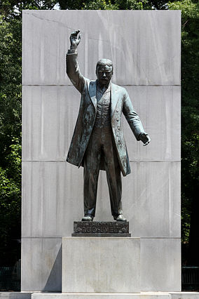
17-foot Centerpiece StatueLocation Washington, D.C., USA Coordinates 38°53′50″N 77°3′51″W / 38.89722°N 77.06417°WCoordinates: 38°53′50″N 77°3′51″W / 38.89722°N 77.06417°W Area 88.5 acres (35.81 ha) Established May 21, 1932 Visitors 111,879 (in 2005) Governing body National Park Service Official website Theodore Roosevelt Island is a 88.5-acre (358,000 m2) island and a national memorial located in the Potomac River in Washington, D.C.[1][2] The island was given to the American people by the Theodore Roosevelt Association in memory of the 26th U.S. president, Theodore Roosevelt.
The island is maintained by the National Park Service as part of the nearby George Washington Memorial Parkway.[2] The land is generally maintained as a natural park, with various trails and a memorial plaza featuring a statue of Roosevelt. No cars or bicycles are permitted on the island, which is reached by a footbridge from Arlington, Virginia, on the western bank of the Potomac.
A small island named "Little Island" lies just off the southern tip; Georgetown and the John F. Kennedy Center for the Performing Arts are across the main channel of the Potomac to the north and east.
Contents
History
 Only the foundation remains of the Mason House, seen here in a 19th-century photograph.
The Nacotchtank Indians, formerly of what is now Anacostia (in Washington, D.C.), temporarily moved to the island in 1668, giving its first recorded name, "Anacostine." The island was patented in 1682 as Anacostine Island by Captain Randolph Brandt, who left the island to his daughter Margaret Hammersley, upon his death in 1698 or 1699.[3] The island was acquired by George Mason in 1724.[4] John Mason, the son of George Mason, inherited the Island in 1792 and owned it until 1833.[3] John Mason built a mansion and planted gardens there in the early 19th century. The Masons left the island in 1831 when a causeway stagnated the water.
Aside from a brief period in the Civil War when Union troops were stationed there, the island has been uninhabited since the Masons left. Locals continued to call it "Mason's Island" until the memorial was built there. Around 1906, a fire on the island extensively damaged the mansion.[3] Today, only part of the mansion's foundation remains. From 1913 to 1931, the island was owned by the Washington Gas Light Company, which allowed vegetation to grow unchecked on the island.[3] The island has previously been known as My Lord's Island, Barbadoes Island, Mason's Island, Analostan Island, and Anacostine Island,[5]
National park and memorial
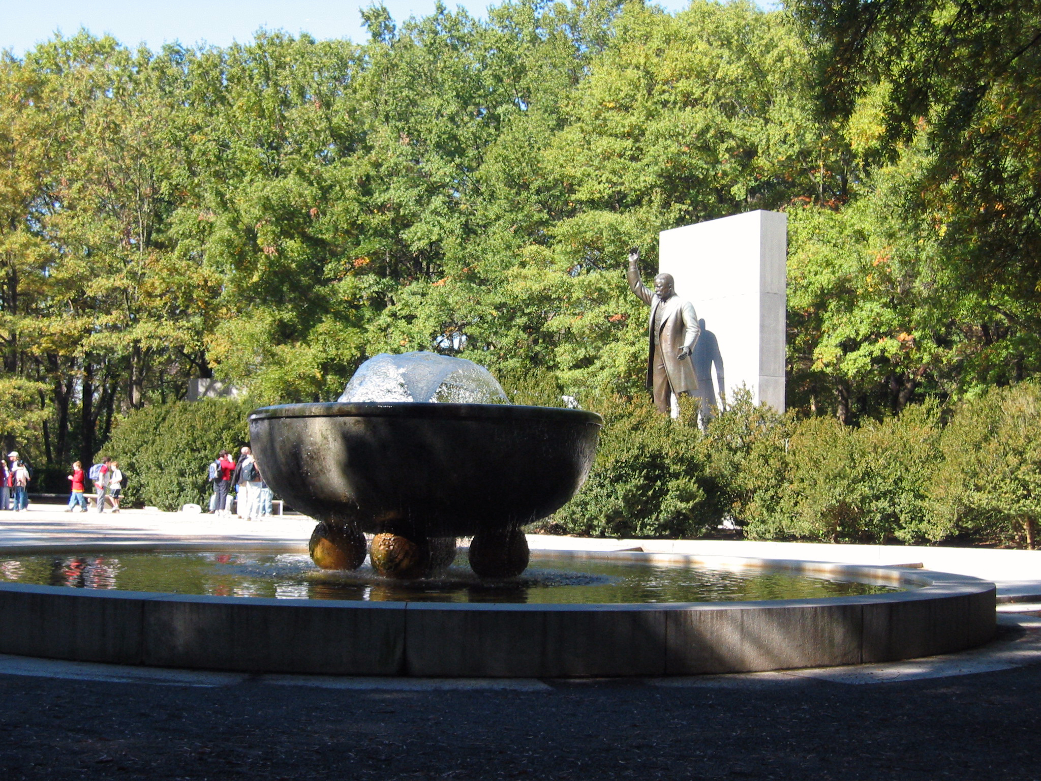
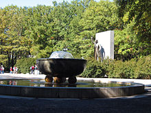 Fountain on Theodore Roosevelt Island, statue in background
In 1931, the Theodore Roosevelt Memorial Association purchased the island from the gas company with the intention of erecting a memorial honoring Roosevelt.[3] Congress authorized the memorial on May 21, 1932, but did not appropriate funds for the memorial for almost three decades.
Funds were finally designated by Congress in 1960. As with all historic areas administered by the National Park Service, the national memorial is listed on the National Register of Historic Places; the listing first appeared on October 15, 1966.
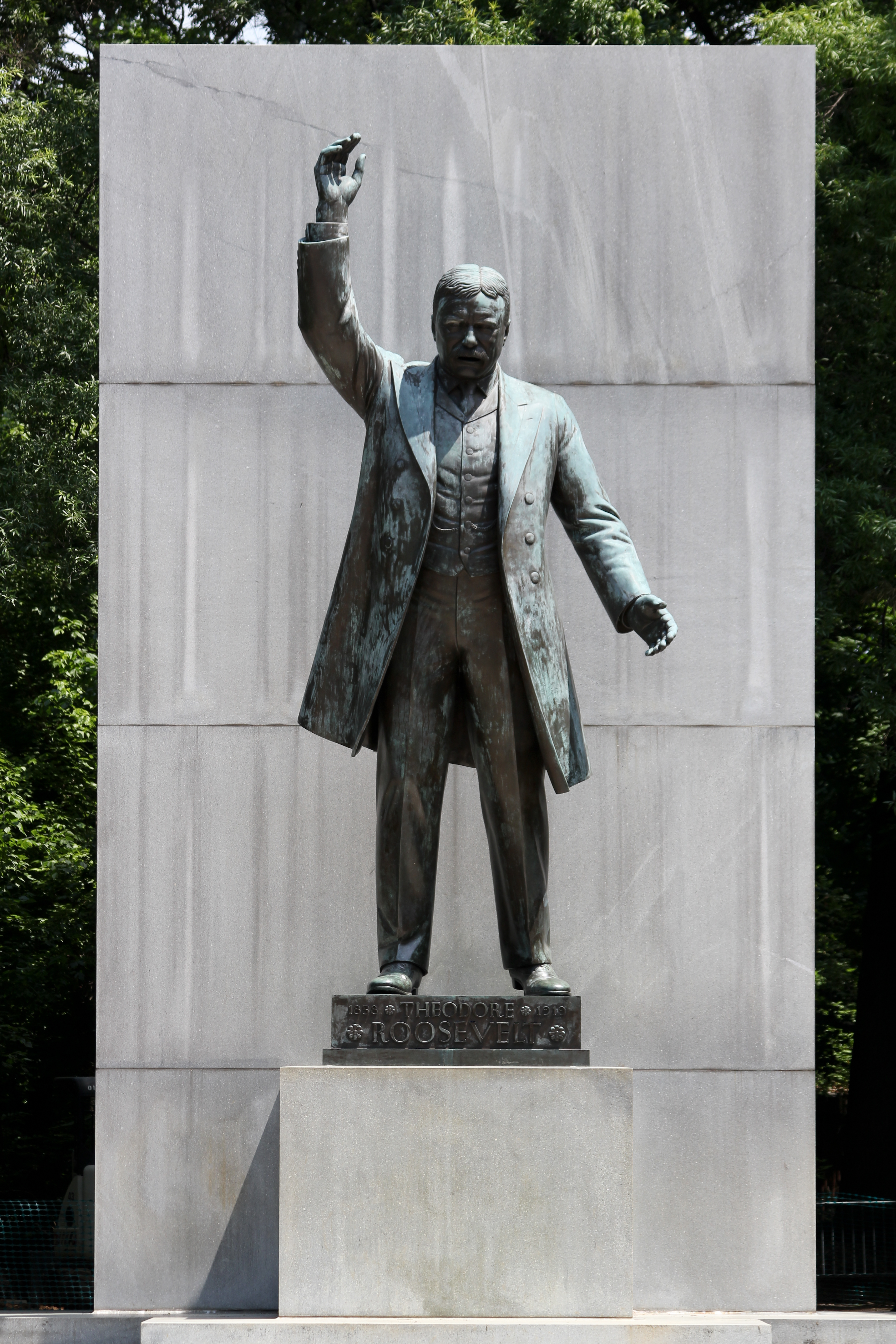
The memorial was dedicated on October 27, 1967.[6] Designed by Eric Gugler, the memorial includes a 17-foot (5 m) statue by sculptor Paul Manship, four large stone monoliths with some of Roosevelt's more famous quotations, and two large fountains.
Geography and natural history
The Potomac River surrounding the island is at sea level, part of the Chesapeake Bay estuary, with the river water fresh but tidal. A narrow channel separates the island from the Virginia bank of the Potomac, with the main channel of the Potomac between the island and Georgetown, part of Washington, D.C. Surrounding scenery includes the Potomac Gorge and Key Bridge, Georgetown, Rosslyn, and the Kennedy Center. Since the Virginia state line follows the southern bank of the river, the island is entirely in the District of Columbia.
The rocky western (upriver) and central portions of the island are part of the Piedmont Plateau, while the southeastern part is within the Atlantic Coastal Plain. At one point opposite Georgetown, the Atlantic Seaboard "Fall Line" between the Piedmont and the Coastal Plain can be seen as a natural phenomenon. The island has about 2.5-mile (4.0 km) of shoreline,[2] and the highest area of the island (where the Mason mansion stood) is about 44 feet (13 m) above sea level.
Spring floods coming down the Potomac from Appalachia inundate low-lying portions of island's shores regularly, usually several times each year, while much larger floods, often from intense, widespread rainfall from tropical storms, flood the island more deeply several times a century. Storm surges coming up the Potomac from hurricanes or other coastal storm systems also cause occasional major floods affecting the island.
The island's vegetation is quite diverse for a relatively small area, due to its geological and topographic variety, the frequency of floods, its land-use history (including various periods of landscaping), and its location in an urban area in which many non-native species occur. Most of the island is deciduous forest of various kinds, including uplands, riparian shores, and swamps. There is also an area of fresh-water tidal (estuarine) marsh, and a few small bedrock outcrops of metamorphic Piedmont rock, some along the tidal shore. The variety of freshwater estuarine intertidal habitats along the island's shores is particularly notable.
The island is particularly known for its variety of birds and its showy displays of spring wildflowers. However, dozens of kinds of non-native invasive plants have become abundant there, often locally outcompeting the native species.
Access
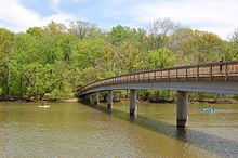 The footbridge to the island
Theodore Roosevelt Island is accessible by a footbridge from a parking lot along the Virginia bank of the Potomac River, just north of the Theodore Roosevelt Bridge, which crosses but does not allow access to the island. Cars can enter this parking lot only from the northbound lanes of the George Washington Memorial Parkway.
Pedestrians and bicylists can reach the parking lot and footbridge by following the Mount Vernon Trail south from the intersection of Lee Highway and N. Lynn St. in Rosslyn, near Key Bridge. The closest Washington Metro station to the island is the Rosslyn station.[7]
Several hiking trails provide access to the memorial and a variety of the island's natural habitats, including a boardwalk through a swampy and marshy area.[2]
See also
References
- ^ National Park Service. "Listing of area as of 09/30/2005". http://www2.nature.nps.gov/stats/acrebypark05fy.pdf. Retrieved May 5, 2006.
- ^ a b c d "Theodore Roosevelt Island". U.S. National Park Service. http://www.nps.gov/this/index.htm. Retrieved 25 June 2011.
- ^ a b c d e Curry, Mary E. (1971-1972). "Theodore Roosevelt Island: A Broken Link to Early Washington, D.C. History". Records of the Columbia Historical Society of Washington, D.C..
- ^ James W. Foster, "Potomac River Maps of 1737 by Robert Brooke and Others," William and Mary College Quarterly Historical Magazine 2nd Ser., Vol. 18, No. 4. (October 1938), 410.
- ^ "Theodore Roosevelt Island". U.S. Geographic Survey: Geographic Names Information System. http://geonames.usgs.gov/pls/gnispublic/f?p=gnispq:3:1176373725906468::NO::P3_FID:531468. Retrieved 2009-01-13.
- ^ The National Parks: Index 2001–2003. Washington: U.S. Department of the Interior.
- ^ "NPS: Theodore Roosevelt Island". http://www.nps.gov/this/planyourvisit/directions.htm.
External links
- Official NPS website: Theodore Roosevelt Island
- Theodore Roosevelt Association
- General John Mason House Information about the historical mansion that was located on the island.
The Mason family First generation George Mason ISecond generation George Mason II{{Ian Thurston}}Third generation George Mason IIIFourth generation George Mason IV • Thomson Mason (1733–1785)Fifth generation George Mason V • William Mason • Thomson Mason (1759–1820) • Stevens Thomson Mason (1760–1803) • John Thomson Mason (1765–1824) • John Mason • Thomas Mason • William Temple Thomson MasonSixth generation Thomson Francis Mason • George Mason VI • John Thomson Mason (1787–1850) • Armistead Thomson Mason • Richard Chichester Mason • Richard Barnes Mason • James Murray Mason • Murray Mason • John Thomson Mason (1815–1873)Seventh generation Stevens Thomson Mason (1811–1843) • George Thomson Mason • Beverley Randolph Mason • Arthur Pendleton Mason • William Pinckney MasonEighth generation Kate Mason Rowland • Richard Nelson MasonMason family residences: Accokeek • Analostan Island • Araby • Chestnut Hill • Chopawamsic • Clarens • Clermont • Colross • Gunston Hall • Hollin Hall • Huntley • Lexington • Locust Hill • Mattawoman • Montpelier • Okeley Manor • Raspberry Plain • Selma • Stafford Hall • Temple Hall • Woodbridge Categories:- IUCN Category V
- 1932 establishments
- Buildings and monuments honoring American Presidents
- Islands of the Potomac River
- Islands of Washington, D.C.
- Artworks in the collection of the United States National Park Service
- National Memorials of the United States
- Monuments and memorials in Washington, D.C.
- National Register of Historic Places in Washington, D.C.
- Theodore Roosevelt
- Mason family residences
- Plantations in Washington, D.C.
- United States National Park Service areas in Washington, D.C.
- Protected areas of Washington, D.C.


Wikimedia Foundation. 2010.