- Ouachita Parish, Louisiana
-
Ouachita Parish, Louisiana 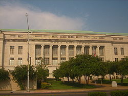 Ouachita Parish Courthouse in Monroe, Louisiana, is another project of the contractor George A. Caldwell
Seal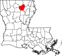
Location in the state of Louisiana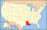
Louisiana's location in the U.S.Founded 1807 Named for Ouachita people Seat Monroe Largest city Monroe Area
- Total
- Land
- Water
633 sq mi (1,639 km²)
611 sq mi (1,581 km²)
22 sq mi (57 km²), 3.50%Population
- (2000)
- Density
147, 250
241/sq mi (93/km²)Time zone Central: UTC-6/-5  Ouachita Parish Public Library in downtown West Monroe
Ouachita Parish (French: Paroisse d'Ouachita) is a parish (population 147,250 as of the 2000 census) located in the U.S. state of Louisiana. The parish seat is Monroe.
Ouachita Parish is part of the Monroe Metropolitan Statistical Area as well as the Monroe–Bastrop Combined Statistical Area.
Contents
History
Prehistory
Main article: History of Louisiana#PrehistoryOuachita Parish was the home to many succeeding Native American groups in the thousands of years before European settlements began. Peoples of the Marksville culture, Troyville culture, Coles Creek culture and Plaquemine culture built villages and mound sites throughout the area. Notable examples include the Filhiol Mound Site, located on a natural levee of the Ouachita River.[1]
Historic era
The parish bears the same name as the Ouachita River, which flows through southern Arkansas and northeastern Louisiana. In 1541, the first Europeans to set foot on the territory that is now Ouachita parish was the expedition of Spanish explorer and conquistador Hernando de Soto. After crossing over onto the west bank of the Mississippi River near the White River, the expedition descended into Louisiana near the junction of the Ouachita and Tensas Rivers to avoid the muddy western banks of the Mississippi River. French settlers arrived in Ouachita Parish around 1720. In 1769, Alejandro O'Reilly claimed Ouachita Parish for Spain. A census of the parish was taken and the result was 110 people. In 1785, Juan Filhiol established the first European outpost in Louisiana, called Fort Miro, which became a city in 1805. Fort Miro was renamed the Ouachita Post in 1819, sixteen years after the Louisiana Purchase was signed. The Ouachita Post grew so large that it later became the city of Monroe around 1820, which is named for the first powered steamboat to sail the Ouachita River. On March 31, 1807, the Territory of New Orleans was divided into 19 sub-districts. Ouachita Parish was one of these original 19 but was later broken up into eight other parishes (Morehouse, Caldwell, Union, Franklin, Tensas, Madison, East Carroll, and West Carroll). In 1853, Cottonport was formed in the northern part of Trenton. Finally, in 1882, Trenton was incorporated, only to surrender the town's charter in 1886. In 1883, the first railroad bridge across the Ouachita River was built. In 1916, the Monroe natural gas field was discovered. The field stretched over 500 square miles (1,000 km2) and was estimated to have 6,500,000,000,000 cubic feet (180 km3) of natural gas in it. This is what caused the city of Monroe to be known as the natural gas capital of the world for a time. The town of Sterlington was incorporated in August 1961, and in 1974 the town of Richwood was incorporated.
Geography

The parish has a total area of 633 square miles (1,640 km2), of which, 611 square miles (1,580 km2) of it is land and 22 square miles (57 km2) of it (3.50%) is water.
Major highways
 Interstate 20
 U.S. Highway 80
 U.S. Highway 165
 Louisiana Highway 2
 Louisiana Highway 15
 Louisiana Highway 34
Adjacent parishes
- Union Parish (north)
- Morehouse Parish (northeast)
- Richland Parish (east)
- Caldwell Parish (south)
- Jackson Parish (southwest)
- Lincoln Parish (west)

Union Parish Morehouse Parish Lincoln Parish 
Richland Parish  Ouachita Parish, Louisiana

Jackson Parish Caldwell Parish National protected areas
Demographics
As of the census[2] of 2000, there were 147,250 people, 55,216 households, and 38,319 families residing in the parish. The population density was 241 people per square mile (93/km²). There were 60,154 housing units at an average density of 98 per square mile (38/km²). The racial makeup of the parish was 64.48% White, 33.63% Black or African American, 0.23% Native American, 0.64% Asian, 0.03% Pacific Islander, 0.33% from other races, and 0.67% from two or more races. 1.19% of the population were Hispanic or Latino of any race.
Census Pop. %± 1900 20,947 — 1910 25,830 23.3% 1920 30,319 17.4% 1930 54,337 79.2% 1940 59,168 8.9% 1950 74,713 26.3% 1960 101,663 36.1% 1970 115,387 13.5% 1980 139,241 20.7% 1990 142,191 2.1% 2000 147,250 3.6% Est. 2006 149,259 [3] 1.4% Ouachita Parish Census Data[4] There were 55,216 households out of which 34.20% had children under the age of 18 living with them, 47.70% were married couples living together, 17.90% had a female householder with no husband present, and 30.60% were non-families. 25.80% of all households were made up of individuals and 9.30% had someone living alone who was 65 years of age or older. The average household size was 2.58 and the average family size was 3.12.
In the parish the population was spread out with 27.90% under the age of 18, 12.00% from 18 to 24, 27.90% from 25 to 44, 20.30% from 45 to 64, and 11.80% who were 65 years of age or older. The median age was 32 years. For every 100 females there were 89.30 males. For every 100 females age 18 and over, there were 84.50 males.
The median income for a household in the parish was $32,047, and the median income for a family was $40,206. Males had a median income of $31,616 versus $23,139 for females. The per capita income for the parish was $17,084. About 15.80% of families and 20.70% of the population were below the poverty line, including 29.70% of those under age 18 and 15.80% of those age 65 or over.
2008 presidential election results
Republican John McCain won 41,741 votes (62 percent) in Ouachita Parish. Democrat Barack Obama trailed with 24,813 votes (37 percent). Other candidates polled the remaining 1 percent of the vote.
Communities
 Map of Ouachita Parish, Louisiana With Municipal Labels
Cities and towns
Census-designated places
Other community
- Calhoun
Media
A documentary entitled The Gift of the Ouachita by filmmaker George C. Brian (1919–2007), head of the Division of Theater and Drama at the University of Louisiana at Monroe is a history of Monroe as the "gift of the Ouachita River."
Education
Primary and Secondary Schools
Ouachita Parish School Board serves areas outside of the City of Monroe. Monroe City School System serves areas within Monroe. Monroe is also the home of The University Of Louisiana at Monroe.
Notable residents
- Frank Hoffmann
- Sam Little
- Don Shows
- Mike Walsworth
National Guard
1022nd Engineer Company (Vertical) of the 527th Engineer Battalion of the 225th Engineer Brigade is located in West Monroe. 528th Engineer Battalion (To The Very End) also part of the 225th Engineer Brigade is headquartered the Monroe.
See also
References
- ^ "Indian Mounds of Northeast Louisiana:Filhiol Mound". http://www.crt.state.la.us/archaeology/moundsguide/filhiol.html. Retrieved 2011-10-20.
- ^ "American FactFinder". United States Census Bureau. http://factfinder.census.gov. Retrieved 2008-01-31.
- ^ United States Census Bureau. "Ouachita Parish Quickfacts". http://quickfacts.census.gov/qfd/states/22/22073.html. Retrieved 2008-02-02.
- ^ United States Census Bureau. "Louisiana Population of Counties by Decennial Census: 1900 to 1990". http://www.census.gov/population/cencounts/la190090.txt. Retrieved 2008-02-02.
Municipalities and communities of Ouachita Parish, Louisiana Cities 
Towns CDPs Unincorporated
communityCalhoun
Categories:- Louisiana parishes
- Ouachita Parish, Louisiana
- Monroe, Louisiana metropolitan area


Wikimedia Foundation. 2010.