- Jefferson Davis Parish, Louisiana
-
Jefferson Davis Parish, Louisiana 
Location in the state of Louisiana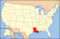
Louisiana's location in the U.S.Founded 1912 Named for Confederate President Jefferson Davis Seat Jennings Largest city Jennings Area
- Total
- Land
- Water
659 sq mi (1,706 km²)
652 sq mi (1,689 km²)
6 sq mi (16 km²), 0.95%Population
- (2000)
- Density
31,435
48/sq mi (19/km²)Time zone Central: UTC-6/-5 Jefferson Davis Parish (French: Paroisse de Jefferson Davis) is a parish located in the U.S. state of Louisiana. The parish seat is Jennings. As of 2000, its population was 31,435. Jefferson Davis Parish is named after the president of the Confederacy during the American Civil War, Jefferson Davis. It is located in southwestern Louisiana and forms a part of the Acadiana region. In 2005, the parish was damaged significantly by Hurricane Rita, which caused much wind damage and flooding in the western part of the parish. The storm also caused Lacassine National Wildlife Refuge to be affected by saltwater intrusion.
Jefferson Davis Parish is part of the Jennings Micropolitan Statistical Area as well as the Lake Charles–Jennings Combined Statistical Area.
The first oil in Louisiana was drilled in 1901 in what became Jeff Davis Parish by W. Scott Heywood, who in 1932 was elected to the Louisiana State Senate.[1]
Contents
History
Jefferson Davis Parish was one of the last incorporated parishes in the state of Louisiana. Originally a part of Imperial Calcasieu Parish, it became a separate entity in the year 1912. Jefferson Davis Parish is also a part of the Acadiana region of Louisiana. It is named after the President of the Confederate States of America, Jefferson Davis.
Geography
The parish has a total area of 659 square miles (1,706.8 km2), of which 652 square miles (1,688.7 km2) is land and 6 square miles (15.5 km2) (0.95%) is water.
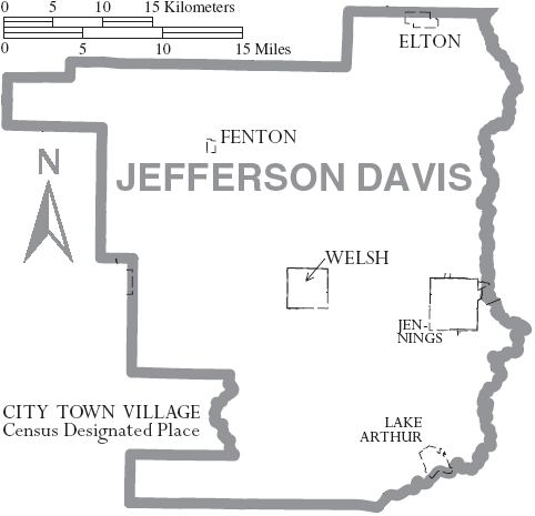
Jefferson Davis Parish comprises five incorporated towns including Elton, Fenton, Jennings, Lake Arthur, and Welsh. There are also many unincorporated areas that add to the interest and economic structure of the parish including Barnsdall, Buller, China, Coverdale, Edna, Foremans Hall, Hathaway, Illinois Plant, Lacassine, Lauderdale, Panchoville, Pine Island, Raymond, Roanoke, Silverwood, Thornwell, Topsy, Verret, and Woodlawn. With a population of approximately 31,435 and a total land area of 652 square miles (1,690 km2), Jefferson Davis Parish is a quaint, rural community that is strategically positioned for success. Centered between New Orleans and Houston, each less than away, Jefferson Davis Parish can be easily accessed for business ventures. Interstate 10 runs east and west through the center of the parish, providing quick, easy access to local markets. Additionally, Union Pacific Railroad is centrally located within the parish and the Mermentau River, which connects to the Intracoastal Waterway and has a channel depth of nine feet, provides access to the Port of Mermentau. The Jennings Airport, with a runway length of 5,000 feet (1,500 m), is capable of landing a small jet and is conveniently located next to Interstate 10. Thanks to these and many other attributes within its community, the overall economic outlook for the parish is promising. Jefferson Davis Parish also attracts sportsmen to the Lacassine National Wildlife Refuge.
Major highways
 Interstate 10
 U.S. Highway 90
 U.S. Highway 165
 Louisiana Highway 14
 Louisiana Highway 26
 Louisiana Highway 97
 Louisiana Highway 99
 Louisiana Highway 101
 Louisiana Highway 102
 Louisiana Highway 380
 Louisiana Highway 382
 Louisiana Highway 395
Airports
- Jennings, (3R7)
Jennings, USA IATA: none – ICAO: K3R7 Summary Airport type Public Location Jennings, LA Elevation AMSL 23 ft / 7 m Coordinates 30°14′33″N 92°40′24″W / 30.2425°N 92.67333°W Runways Direction Length Surface ft m 08/26 5,000 1,524 Asphalt 13/31 3,598 1,097 Asphalt 17/35 2,000 610 Turf Adjacent parishes
- Allen Parish (north)
- Evangeline Parish (northeast)
- Acadia Parish (east)
- Vermilion Parish (southeast)
- Cameron Parish (south)
- Calcasieu Parish (west)
- Beauregard Parish (northwest)
Demographics
As of the census[2] of 2000, there were 31,435 people, 11,480 households, and 8,529 families residing in the parish. The population density was 48 people per square mile (19/km²). There were 12,824 housing units at an average density of 20 per square mile (8/km²). The racial makeup of the parish was 80.60% White, 17.79% Black or African American, 0.38% Native American, 0.19% Asian, 0.01% Pacific Islander, 0.20% from other races, and 0.82% from two or more races. 0.99% of the population were Hispanic or Latino of any race. 16.15% of the population reported speaking French or Cajun French at home.[1]
Census Pop. %± 1920 18,999 — 1930 19,765 4.0% 1940 24,191 22.4% 1950 26,298 8.7% 1960 29,825 13.4% 1970 29,554 −0.9% 1980 32,168 8.8% 1990 30,722 −4.5% 2000 31,435 2.3% Est. 2006 31,418 [3] −0.1% Jefferson Davis Parish Census Data[4] There were 11,480 households out of which 37.20% had children under the age of 18 living with them, 56.80% were married couples living together, 13.70% had a female householder with no husband present, and 25.70% were non-families. 22.60% of all households were made up of individuals and 10.70% had someone living alone who was 65 years of age or older. The average household size was 2.70 and the average family size was 3.18.
In the parish the population was spread out with 29.30% under the age of 18, 9.10% from 18 to 24, 27.30% from 25 to 44, 21.00% from 45 to 64, and 13.30% who were 65 years of age or older. The median age was 34 years. For every 100 females there were 92.50 males. For every 100 females age 18 and over, there were 87.50 males.
The median income for a household in the parish was $27,736, and the median income for a family was $33,129. Males had a median income of $28,279 versus $18,668 for females. The per capita income for the parish was $13,398. About 18.10% of families and 20.90% of the population were below the poverty line, including 25.40% of those under age 18 and 19.90% of those age 65 or over.
Communities
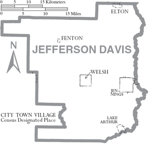 Map of Jefferson Davis Parish, Louisiana With Municipal Labels
Cities and towns
Unincorporated areas
- Lacassine
- Roanoke
- Topsy
Education
Jefferson Davis Parish Public Schools operates public schools in the parish.
Jefferson Davis Parish Library operates public libraries throughout the parish.
The Jefferson Davis Parish Library Headquarters Branch is at 118 West Plaquemine Street in Jennings.
The system operates three branches:
- Elton Branch at 813 Main Street, Elton
- Lake Arthur Branch at 600 4th Street, Lake Arthur
- Welsh Branch at 301 South Sarah Street, Welsh
In addition the City of Jennings operates the Jennings Carnegie Public Library.[5]
Notable residents
- A.C. Clemons
- Thomas A. "Tom" Greene
- John E. Guinn
- Charles Franklin Hildebrand
- Dan Morrish
- Claude Kirkpatrick
- Edith Killgore Kirkpatrick
- Gerald Theunissen
See also
References
- ^ "Heywood, Walter Scott". Louisiana Historical Association, A Dictionary of Louisiana Biography. http://www.lahistory.org/site25.php. Retrieved January 30, 2011.
- ^ "American FactFinder". United States Census Bureau. http://factfinder.census.gov. Retrieved 2008-01-31.
- ^ United States Census Bureau. "Jefferson Davis Parish Quickfacts". http://quickfacts.census.gov/qfd/states/22/22053.html. Retrieved 2008-02-02.
- ^ United States Census Bureau. "Louisiana Population of Counties by Decennial Census: 1900 to 1990". http://www.census.gov/population/cencounts/la190090.txt. Retrieved 2008-02-02.
- ^ "Carnegie Public Library:." City of Jennings. Accessed September 22, 2008.
External links
Geology
- Heinrich, P. V., J. Snead, and R. P. McCulloh, 2002, Lake Charles 30 x 60 minute geologic quadrangle. Louisiana Geological Survey, Baton Rouge, Louisiana.
- Heinrich, P. V., J. Snead, and R. P. McCulloh, 2003, Crowley 30 x 60 minute geologic quadrangle. Louisiana Geological Survey, Baton Rouge, Louisiana.
Municipalities and communities of Jefferson Davis Parish, Louisiana City 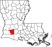
Towns Elton | Lake Arthur | Welsh
Village Unincorporated
communitiesBarnsdall | Bellevue | Buller | China | Coverdale | Edna | Foremans Hall | Gravel Point | Hathaway | Lacassine | Niblett | Panchoville | Pine Island | Raymond | Roanoke | Silverwood | Thornwell | Topsy | Verret | Woodlawn
Categories:- Louisiana parishes
- Acadiana
- Jefferson Davis Parish, Louisiana


Wikimedia Foundation. 2010.