- Grant Parish, Louisiana
-
Grant Parish, Louisiana 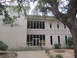 The Grant Parish Courthouse in Colfax
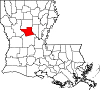
Location in the state of Louisiana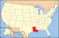
Louisiana's location in the U.S.Founded 1869 Named for U.S. President Ulysses S. Grant Seat Colfax Largest city Colfax Area
- Total
- Land
- Water
665 sq mi (1,721 km²)
656 sq mi (1,671 km²)
19 sq mi (50 km²), 2.93%Population
- (2000)
- Density
18,698
29/sq mi (11/km²)Time zone Central: UTC-6/-5  The Grant Parish Library is located near the courthouse.
 The Grant Parish Sheriff's Office is located behind the courthouse.
 Colfax Reunion Nursing and Rehabilitation Home at 366 Webb Smith Drive in Colfax serves all of Grant Parish.
Grant Parish (French: Paroisse de Grant) is a parish located in the U.S. state of Louisiana. The parish seat is Colfax (pronounced CAHL-facks). It is part of the Alexandria, Louisiana, Metropolitan Statistical Area and Red River valley. From 1940-1960, the parish had a dramatic population loss, as many African Americans left in the Great Migration, to seek better opportunities elsewhere. Such migration continued until about 1970. As of 2000, the population was 18,698. Since then, the parish has had the highest growth rate in central Louisiana, as the economy has shifted.
Contents
History
Grant Parish was originally a part of the more populous Rapides Parish to the south. Prior to the American Civil War, the center of activity focused upon "Calhoun's Landing," named for the cotton and sugar planter Meredith Calhoun, a native of South Carolina. Calhoun also published the former National Democrat newspaper in what became Colfax, the seat of government of the new parish.[1]
Grant was one of several new parishes created by the Reconstruction legislature in an attempt to build the Republican Party. Founded in 1869, it had a slight majority of freedmen. It was named for U.S. President Ulysses S. Grant. The parish seat of Colfax was named for Grant's first vice president, Schuyler M. Colfax (pronounced COAL-facks) of Indiana. However, the town of Colfax is prounounced CAHL-facks. The parish encompassed both cotton plantations and pinewoods. It was one of several areas along the Red River that had considerable violence during Reconstruction, as whites tried to maintain social control.
The gubernatorial election of 1872 was disputed, leading to both parties' certifying their slates of local officers. The election was finally settled in favor of the Republican candidates, but the decision was disputed in certain areas. As social tensions rose, Republican officials took their places at the courthouse in Colfax. They were defended by freedmen and state militia (mostly made up of freedmen), who feared a Democratic Party takeover of the parish. Amid widespread rumors, whites organized a militia and advanced on the courthouse on Easter Sunday, 1873. In the ensuing violence, three whites and 120-150 blacks were killed, including 50 that night who were held as prisoners. Leading 20th-century historians renamed the Colfax Riot, the original state designation, as the Colfax Massacre. The total number of freedmen deaths were never established because some of the bodies were thrown into the river and woods.
The white militia was led by Christopher Columbus Nash, a Confederate officer who had been a prisoner of war at Johnson's Island in Ohio. It consisted of veterans from Grant and neighboring parishes. The following year, Nash gathered many of the white militia members as the basis of the first chapter of the White League. Other chapters quickly grew up across the state. The White League's organized violence in support of the Democratic Party included widespread intimidation of black voters. The League was integral to white Democrats' regaining power in the state by 1876. Soon after, they effectively disfranchised most blacks, a situation that persisted until after the Civil Rights-era legislation of the mid-1960s.
21st century
Grant Parish had the highest growth rate in central Louisiana in the five-year period between 2001 and 2006, according to projections of the United States Census Bureau. The parish has had a 4.3 percent growth rate compared to 1.7 percent for its larger neighbor, Rapides Parish. Some neighboring parishes, including Winn, have experienced population decreases.[2]
Geography
The parish has a total area of 665 square miles (1,720 km2), of which 645 square miles (1,670 km2) is land and 19 square miles (49 km2) (2.93%) is water.
Major highways
 U.S. Highway 71
 U.S. Highway 165
 U.S. Highway 167
 Louisiana Highway 8
 Louisiana Highway 34
 Louisiana Highway 122
 Louisiana Highway 123
 Louisiana Highway 472
 Louisiana Highway 500
Adjacent parishes
- Winn Parish (north)
- La Salle Parish (east)
- Rapides Parish (south)
- Natchitoches Parish (west)

Winn Parish Natchitoches Parish 
La Salle Parish  Grant Parish, Louisiana

Rapides Parish National protected area
- Kisatchie National Forest (part)
Demographics
Census Pop. %± 1900 12,902 — 1910 15,958 23.7% 1920 14,403 −9.7% 1930 15,709 9.1% 1940 15,933 1.4% 1950 14,263 −10.5% 1960 13,330 −6.5% 1970 13,671 2.6% 1980 16,703 22.2% 1990 17,526 4.9% 2000 18,698 6.7% Est. 2006 19,879 [3] 6.3% Grant Parish Census Data[4] As of the census[5] of 2000, there were 18,698 people, 7,073 households, and 5,276 families residing in the parish. The population density was 29 people per square mile (11/km²). There were 8,531 housing units at an average density of 13 per square mile (5/km²). The racial makeup of the parish was 85.43% White, 11.88% Black or African American, 0.89% Native American, 0.14% Asian, 0.03% Pacific Islander, 0.36% from other races, and 1.28% from two or more races. 1.14% of the population were Hispanic or Latino of any race.
The decreases in population from 1910–1920, and from 1940–1960, were chiefly caused by different phases of the Great Migration, as African Americans left segregation and oppression of the South to seek better opportunities in the North, during the first phase, and in the West, especially California's defense industry, in the second phase. Tens of thousands of migrants left Louisiana during times of agricultural difficulties and the collapse of agricultural labor after mechanization.[6]
In 2000, there were 7,073 households out of which 36.50% had children under the age of 18 living with them, 57.20% were married couples living together, 12.90% had a female householder with no husband present, and 25.40% were non-families. 22.60% of all households were made up of individuals and 10.10% had someone living alone who was 65 years of age or older. The average household size was 2.61 and the average family size was 3.06.
In the parish the population was spread out with 28.30% under the age of 18, 7.90% from 18 to 24, 28.10% from 25 to 44, 23.00% from 45 to 64, and 12.70% who were 65 years of age or older. The median age was 36 years. For every 100 females there were 96.10 males. For every 100 females age 18 and over, there were 93.00 males.
The median income for a household in the parish was $29,622, and the median income for a family was $34,878. Males had a median income of $31,235 versus $20,470 for females. The per capita income for the parish was $14,410. About 16.90% of families and 21.50% of the population were below the poverty line, including 27.30% of those under age 18 and 16.20% of those age 65 or over.
Government and infrastructure
The Federal Bureau of Prisons U.S. Penitentiary, Pollock is located in an unincorporated area in the parish, near Pollock.[7][8]
Cities and towns
 Map of Grant Parish, Louisiana With Municipal Labels
Education
Public schools in Grant Parish are operated by the Grant Parish School Board.
Notable people
- W. K. Brown, state representative from Grant Parish from 1960 to 1972
- Billy Ray Chandler, state representative from Grant Parish since 2006
- Preston Allen "Pap" Dean, Jr., cartoonist and Colfax native
- P. Elmo Futrell, Jr., mayor of Pineville, 1962–1966, was originally from Grant Parish.
- Stephen Lee "Steve" Gunn, former mayor of Montgomery; represented Grant Parish in the legislature as an Independent from 1992–1996
- Leonard "Pop" Hataway, sheriff of Grant Parish (1976–2008), member of Louisiana Board of Pardons
- Ed Head (1918–1980), Major League Baseball player who played for the Brooklyn Dodgers
- Caledonia Palestine Tyson Long (1860–1913), the mother of Governors Huey Pierce Long, Jr., and Earl Kemp Long, was born in Grant Parish.[9]
- Wyatt Luther Nugent (1891-1936) - Sheriff of Grant Parish killed in the line of duty, along with a deputy, Delmer Lee Brunson[10]
- W.L. Rambo, member of both houses of the Louisiana State Legislature from Georgetown.
- Joe D. Smith, Jr., the publisher of the Alexandria Daily Town Talk from 1962 until his retirement in 1996, was a native of Grant Parish.
- Richard S. Thompson (1916-1997), state representative from Grant Parish from 1972 to 1984
See also
References
- ^ "Calhoun, Meredith". Louisiana Historical Association, A Dictionary of Louisiana Biography (lahistory.com). http://www.lahistory.org/site20.php. Retrieved December 22, 2010.
- ^ Alexandria Daily Town Talk, December 20, 2006
- ^ United States Census Bureau. "Grant Parish Quickfacts". http://quickfacts.census.gov/qfd/states/22/220439.html. Retrieved 2008-02-02.
- ^ United States Census Bureau. "Louisiana Population of Counties by Decennial Census: 1900 to 1990". http://www.census.gov/population/cencounts/la190090.txt. Retrieved 2008-02-02.
- ^ "American FactFinder". United States Census Bureau. http://factfinder.census.gov. Retrieved 2008-01-31.
- ^ "African American Migration Experience: The Second Great Migration", New York Public Library, Schomburg Center for Research in Black Culture, accessed 24 April 2008
- ^ "USP Pollock." Federal Bureau of Prisons. Retrieved on May 29, 2010.
- ^ "USP Pollock Contact Information." Federal Bureau of Prisons. Retrieved on May 29, 2010.
- ^ Long Families of Corinith and Zion - Winn Parish, LA
- ^ "Sheriff Wyatt Luther Nugent, Deputy Delmer Lee Brunson [Killed"]. libertychapelcemetery.org. http://www.libertychapelcemetery.org/files/sheriff.html. Retrieved January 15, 2011.
Municipalities and communities of Grant Parish, Louisiana Towns Colfax | Montgomery | Pollock

Villages Unincorporated
communitiesBently | Packton | Rochelle | Selma | Verda
Categories:- Louisiana parishes
- Grant Parish, Louisiana
- Alexandria, Louisiana metropolitan area


Wikimedia Foundation. 2010.