- 2008 North Indian Ocean cyclone season
-
2008 North Indian Ocean cyclone season 
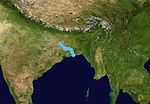
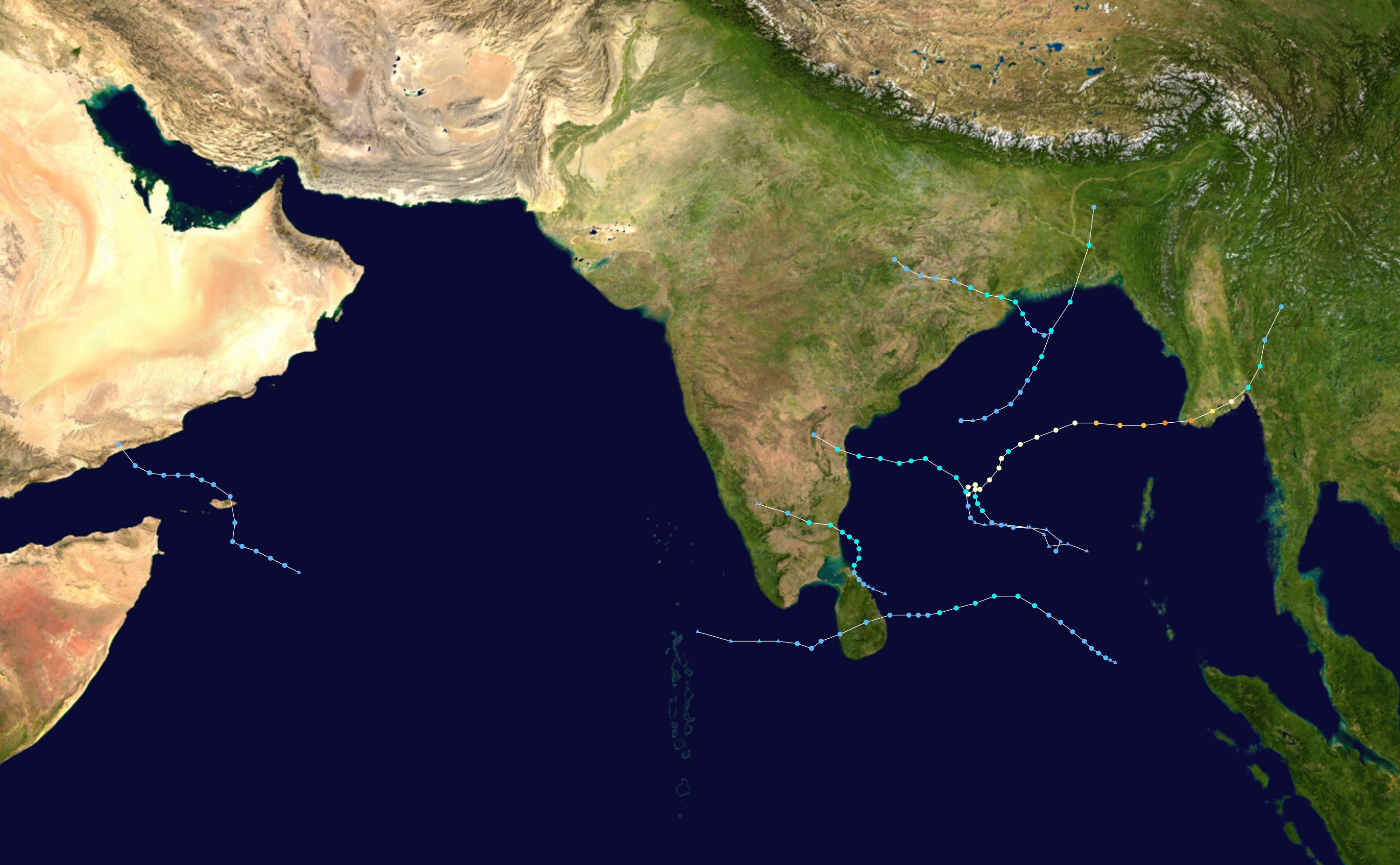
Season summary mapFirst storm formed: April 27, 2008 Last storm dissipated: December 8, 2008 Strongest storm: Nargis – 962 hPa (mbar), 165 km/h (105 mph) (3-minute sustained) Depressions: 10 Deep depressions: 7 Cyclonic storms: 4 Severe cyclonic storms: 1 Very severe cyclonic storms: 1 Super cyclonic storms: 0 Total fatalities: at least 138,000 Total damage: ~ $12 billion (2008 USD) North Indian Ocean cyclone seasons
2006, 2007, 2008, 2009, 2010Related article: The 2008 North Indian cyclone season was an ongoing event in the annual cycle of tropical cyclone formation. The North Indian cyclone season has no official bounds, but cyclones tend to form between April and December, with peaks in May and November. These dates conventionally delimit the period of each year when most tropical cyclones form in the northern Indian Ocean.
The scope of this basin is north of the Equator and west of the Malaysian Peninsula. The India Meteorological Department (IMD) and Joint Typhoon Warning Center (JTWC) monitor tropical cyclones in this basin. This basin is divided into two different seas by India; the Arabian Sea to the west, abbreviated ARB by the IMD, and the Bay of Bengal to the east, abbreviated BOB by the IMD. On average, about 4 to 6 storms form in this basin every season.
The 2008 North Indian Ocean season was average in activity, but was very eventful. This season ranks as the costliest and one of the deadliest seasons on record, with about 12 billion dollars in damage and over 138,000 deaths. Cyclone Nargis was the most notable storm of the season. It caused the worst natural disaster in Myanmar's history, and caused the majority of the damages and deaths this year.
Contents
Storms
Very Severe Cyclonic Storm Nargis
Very severe cyclonic storm (IMD) Category 4 tropical cyclone (SSHS) 

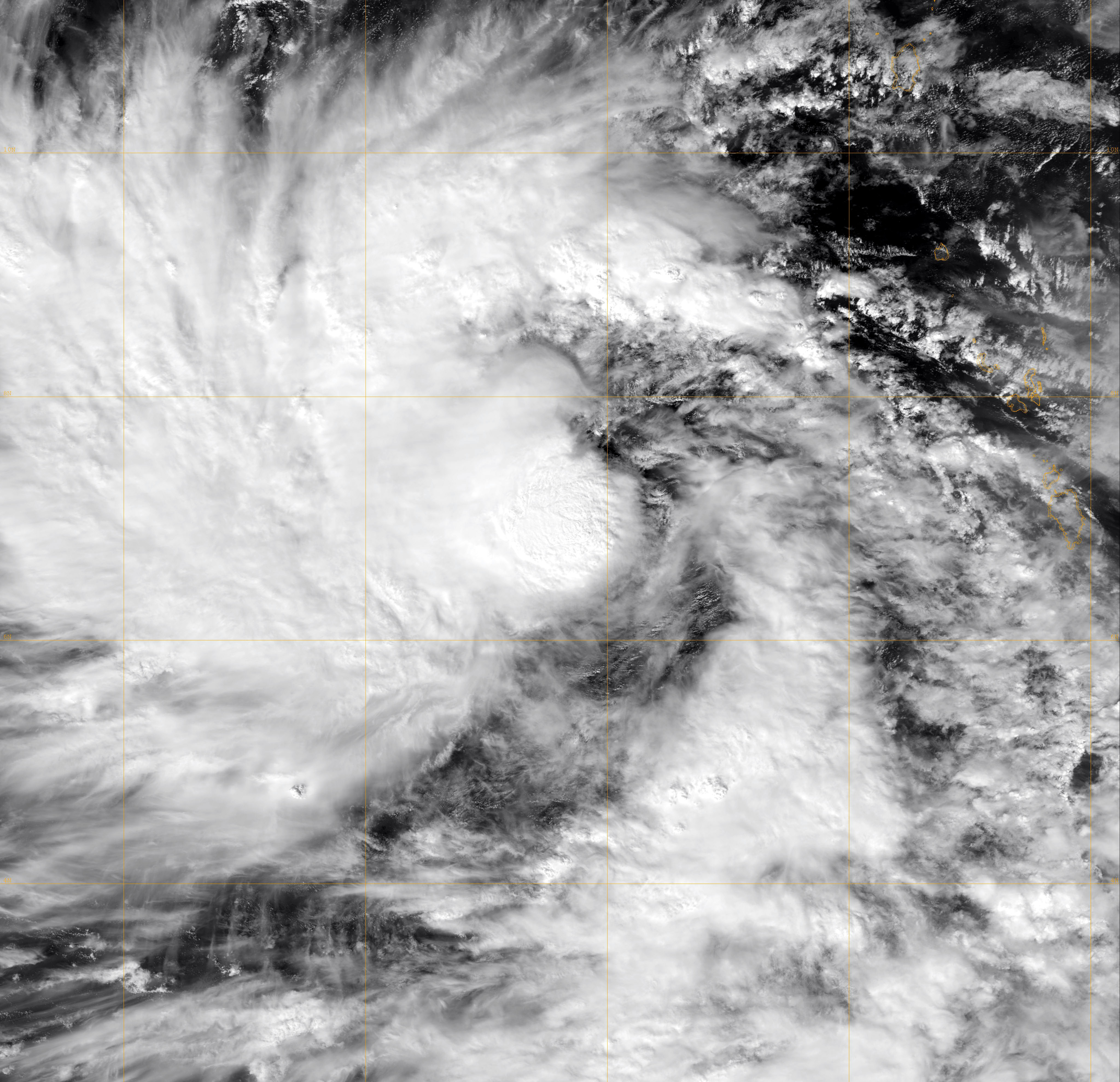
Duration April 27 – May 3 Intensity 165 km/h (105 mph) (3-min), 962 mbar (hPa) Main article: Cyclone NargisAn area of disturbed weather formed east of the Nicobar Islands on April 24. It slowly started moving in a northwesterly direction into an area of low vertical wind shear. The JTWC started issuing statements on the system on April 25.[1] On April 27, the Indian Meteorological Department upgraded it to a depression,[2] and the next day it was upgraded to Cyclonic Storm Nargis.[3] A few hours later it was upgraded to a Severe Cyclonic Storm.[4] The next day it was given the status of a Very Severe Cyclonic Storm with winds up to 90 knots (based on IMD observations) although the JTWC observed peak winds of 115 knots, or 135 mph (215 km/h).[5] Nargis hit southern Burma with 135 mph winds winds and then gradually started dissipating.[6][7]
Damage in Myanmar was extensive, where 243 people have been reported dead according to United Nations officials. Later, there were nearly 4,000 deaths confirmed. It became likely that 15,000 or even 22,000[8] deaths occurred, but this was disputed by officials. Later, 22,980 deaths have been blamed on Nargis and more than 40,000 other people were missing. If they were all killed, then Nargis would be the 6th deadliest cyclone in this basin on record, and the 3rd deadliest in this basin in modern history. The Labutta Township alone reportedly had a toll of 80,000 deaths; 10,000 more were in Bogale, and some estimate the death toll from Nargis being well over 100,000, and is at least as of now around 138,000. So far, Nargis is ranked as the 7th deadliest cyclone of all time and the second deadliest named cyclone of all time, after Typhoon Nina of 1975.[9] Thousands of homes and businesses throughout the country, including in Yangon, were damaged or destroyed by the winds and storm surge. The Irrawaddy Delta also suffered severely from the storm surge.The most affected areas map released by ReliefWeb.[10]
The final toll from Nargis is at least 138,000 people killed in in Myanmar, and about $10 billion dollars in damage (USD).[11]
Depression ARB 01
Depression (IMD) 

Duration June 5 – June 7 Intensity 45 km/h (30 mph) (3-min), 994 mbar (hPa) An area of convection formed north west of India on June 4.[12] Early the next day the IMD designated it as Depression ARB 01.[13] Although it was forecast to intensify further,[14] it did not develop as it turned away from the coast.[15] The IMD downgraded it to an active area of low pressure on June 7 as it weakened over the Arabian Sea.[16]
Depression BOB 02
Depression (IMD) 
Duration June 16 – June 18 Intensity 45 km/h (30 mph) (3-min), 988 mbar (hPa) Early on June 15, an area of low pressure formed within the monsoonal trough over the northern part of the Bay of Bengal.[17] Over the next 24 hours deep convection developed around the low pressure area and thus it was upgraded to Depression BOB 02 early the next day, as it was located about 220 km, (135 miles), southeast of Kolkata, near to the Bangladesh coastline.[17][18] However it as the depression was located within an area of mid to high vertical wind shear it did not develop further.[17] Later that morning before the depression made landfall it reached its peak pressure of 988 hPa/mbar. The depression then made landfall on the Bangladesh coast and slowly weakened into an area of low pressure, whilst located over Jharkhand in India.[17][19] There was heavy rainfall reported in Orissa, West Bengal and Jharkhand parts of India.[17] At least four people were killed by the depression.[20][21] Five other people were reported as missing after a bridge they were driving over collapsed.[22]
Depression BOB 03
Depression (IMD) 
Duration August 9 – August 10 Intensity 45 km/h (30 mph) (3-min), 1004 mbar (hPa) On August 9, a tropical depression formed in the North Indian Ocean, south of Orissa, India.[23] Early the next day, the depression made landfall on the Orissa coast.[24] IMD did not upgrade it until it was overland near Puri.[25] Consequently, it was designated as a land depression in the end of monsoon season report.[26] Later in the day, the IMD issued its final advisory on the depression as it weakened into a low pressure area.[27]
Deep Depression BOB 04
Deep depression (IMD) Tropical storm (SSHS) 
Duration September 15 – September 19 Intensity 55 km/h (35 mph) (3-min), 986 mbar (hPa) On September 14 an area of low pressure formed south east of Kolkata India.[28] During September 15 the IMD designated this area of low pressure as Depression BOB 04.[29] Later that day the JTWC issued a Tropical Cyclone Formation Alert on the tropical depression.[30] During the morning of September 15 the depression intensified into a Deep Depression as it moved closer to the Orissa Coast.[31] Later that day the JTWC issued their first advisory on this system designating it as Tropical Cyclone 02B [32] The Depression then made landfall on the Orissa coast later that day.[33] So the JTWC issued their last advisory on the depression later that day.[34] However the IMD kept issuing advisories on the Deep Depression. The RSMC then downgraded it to a depression on September 18 as it moved further inland.[35] The RSMC issued their final advisory the next day as the depression had weakened in to a well marked low pressure area.[36] The track of Deep Depression making inland into Uttar Pradesh after crossing Orissa [37]
The Deep Depression caused 10 deaths in the state of Orissa.[38] The Depression also caused 15 deaths in Uttar Pradesh, its state capital Lucknow received the heaviest rains for September in the last 10 years.[39] Over 100 fishermen were reported missing as 25 trawlers capsized in the Bay of Bengal off Bangladesh's southern coastal areas as the sea turned rough due to a depression.[40] The Deep Depression also caused storm surge up to 15 to 20 feet high.[41]
Overall, the storm killed at least 25 people in India (10 in Orissa, 15 in Uttar Pradesh), but overall damage was minor.
Deep Depression ARB 02
Depression (IMD) Tropical depression (SSHS) 

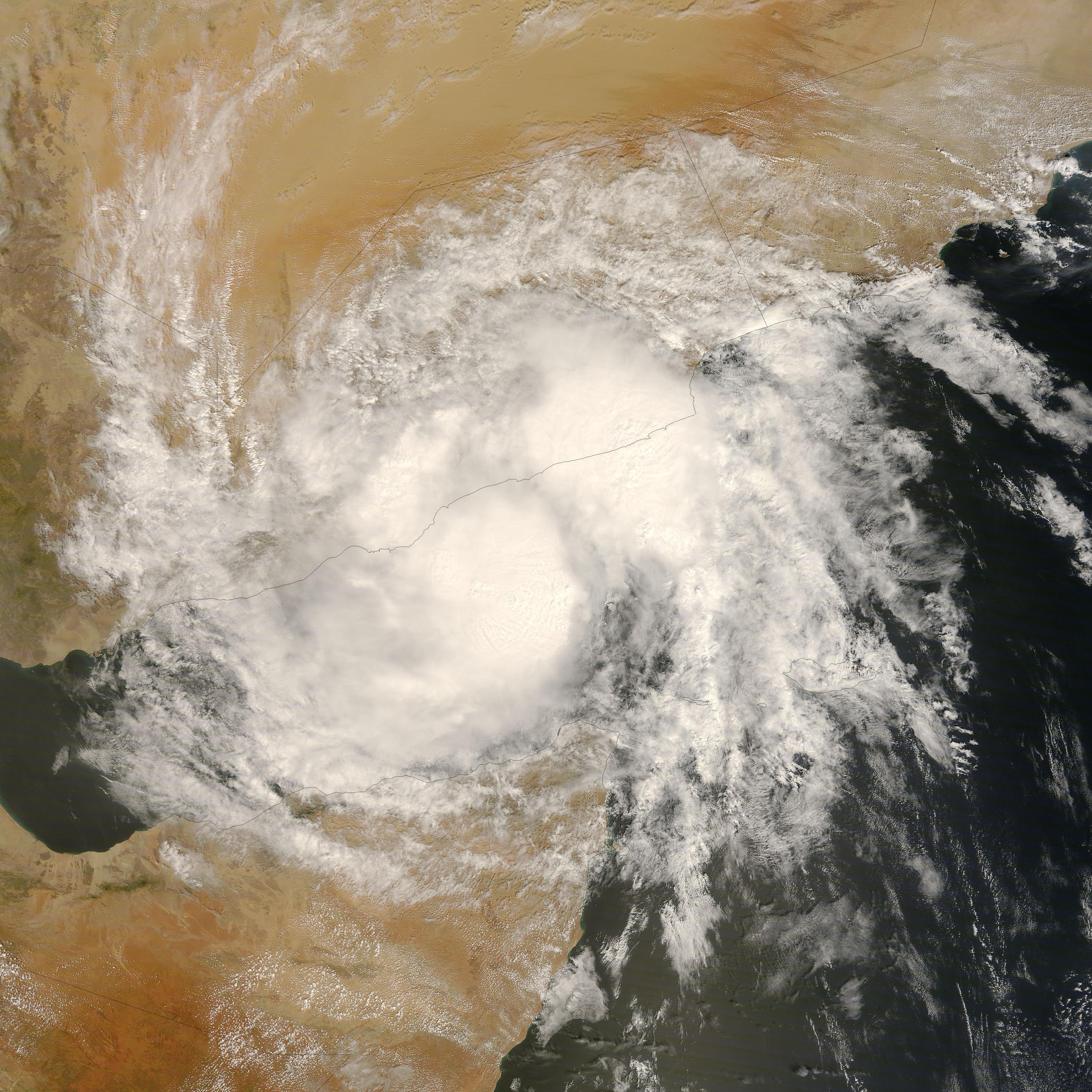
Duration October 19 – October 23 Intensity 45 km/h (30 mph) (3-min), 1000 mbar (hPa) Main article: 2008 Yemen cycloneOn October 19 the IMD noted that an area of low pressure which located to the south east of Salalah, Oman had intensified in to a tropical depression and was assigned the number ARB 02.[42] On October 21 IMD updated the system to a Deep Depression while it lay 700 km south of Salalah, Oman near the east coast of Somalia.[43] It lost its strength while crossing the Gulf of Aden due to entry of dry air and land interaction as it passed close to the northeastern coast of Somalia. It later was downgraded to a Depression,[44] named TC 03B by the JTWC.[45][46]
On October 24 it made landfall on the south-eastern coast of Yemen, leaving at least 26 civilians and six soldiers dead while trapping hundreds of people due to flooding and torrential rainfalls.[47] The latest figure of casualties is of 180 persons dead and 100 others missing, mostly from the region of Hadhramawt, where the storm made landfall.[48][49] 733 houses were destroyed in the governorates of Hadhramawt and Al-Mahrah, while 22,000 people were displaced. The Yemeni Government declared the two aforementioned governorates as disaster zones.[50][51] The most affected areas map released by ReliefWeb.[52]
Overall, this weak storm killed at least 180 people in Yemen. Damage is estimated at about $1 billion (USD).
Cyclonic Storm Rashmi
Main article: Cyclone RashmiCyclonic storm (IMD) Tropical storm (SSHS) 

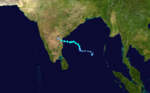
Duration October 25 – October 27 Intensity 85 km/h (50 mph) (3-min), 996 mbar (hPa) On October 25, an area of low pressure which was located east of the Andhra Pradesh coast based on satellite, coastal observations, and buoy data intensified into a depression. The depression remained practically stationary and intensified into a deep depression and lay centred as of 0530 hours IST today, the 26th of October 2008, about 400 km east-northeast of Visakhapatnam, 250 km south-southeast of Paradip and 550 km south-southwest of Kolkata. The Joint Typhoon Warning Center began issuing advisories on the system a few hours later that early morning, designating it as Tropical Cyclone 04B. The IMD named it cyclonic storm Rashmi.The observed track of Deep Depression making inland into Uttar Pradesh after crossing Orissa The track of cyclonic storm Rashmi making landfall in Bangladesh [53]
The Cyclone crossed the Khulna-Barisal coast at Patharghata, Bangladesh on 27 October 2008, with winds of 80 km/hour. 15 people were killed and thousands of homes were also damaged. Rashmi brought down electrical and telephone poles and uprooted trees, large areas of acres of crops were also destroyed.[54] 5 people were also killed in the state of Meghalaya, India.[55] At least 50 fishermen were reported missing when about 15 fishing trawlers capsized offshore.[56]
Rashmi killed at least 28 people. 15 people were killed in Bangladesh and 13 people were killed in India (5 in Meghalaya, 8 in Arunachal Pradesh).[57]
Cyclonic Storm Khai-Muk
Cyclonic storm (IMD) Tropical storm (SSHS) 
Duration November 13 – November 16 Intensity 65 km/h (40 mph) (3-min), 996 mbar (hPa) On November 13, a low pressure area identified by the India Meteorological Department over southeast Bay of Bengal and adjoining areas concentrated into a depression east-southeast of Chennai, India. The IMD expects the system to intensify further and move towards north Tamil-Nadu/south Andhra Pradesh coasts. The Joint Typhoon Warning Center issued a tropical cyclone warning on the tropical cyclone early on November 14 naming it as Tropical Cyclone 05B. A few hours later the IMD upgraded the system to a deep depression issuing a Cyclone Watch for Andhra Pradesh as intensification into a cyclonic storm was possible. By mid morning the IMD advised the eastern coast of India that the system was expected to cross Andhra Pradesh by noon the next day (local time). Later that morning the deep depression intensified into a cyclonic storm and was named Khai-Muk and the cyclone watch was raised to a warning for Andhra Pradesh coast with Khai-Muk forecast to intensify even further before it made landfall in the afternoon or evening of November 15 between Bapatla and Kakinada near Machilipatnam. However, the system became sheared to the western periphery and the IMD downgraded it back into a deep depression. Khai-Muk headed northwest and then northwards after making landfall in Andhra Pradesh.[37] The name Khai-Muk was contributed by Thailand, it means pearl in Thai.
By November 15, all ports in Andhra Pradesh were under cautionary signal number three. All fishermen were advised to remain at port due to rough seas.[58] Residents along the shore were urged to evacuate as waves up to 2 m (6.5 ft) were forecast to impact the coast.[59]
High winds knocked down trees and power lines causing traffic jams throughout the Andhra Pradesh.[60] Boats and fishing nets were washed away by high waves produced by Khai-muk, costing Rs. 2 cores ($430,000 USD).[61] An average of 53.5 mm (2.1 in) of rain fell throughout the state.[60] The highest rainfall was recorded in Bantumilli at 172 mm (6.7 in). An estimated 1.2 million hectares of crops were damaged or destroyed by the storm leading to Rs. 10 cores ($1.9 million USD) in agricultural losses.[62] A total of 148 homes were destroyed and another 23 were damaged, amounting to Rs. 4 crores ($780,000 USD) in monetary losses.[63] A 5 km (3.1 mi) stretch of highway was washed out by the storm and damages to the road amounted to Rs. 4 crores ($780,000 USD).[62]
A state of high alert was declared in Andhra Pradesh following the storm in the state. About 7,500 people were evacuated from several towns to 23 shelters set up by officials. The shelters provided the residents with breakfast and milk on November 16.[60] The following day, a total of 44,949 people had evacuated to 66 relief shelters.[64] The minister of Andhra requested that the government send rice, pulses, oil and other materials to cyclone victims.[61]
Cyclonic Storm Nisha
Cyclonic storm (IMD) Tropical storm (SSHS) 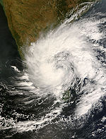

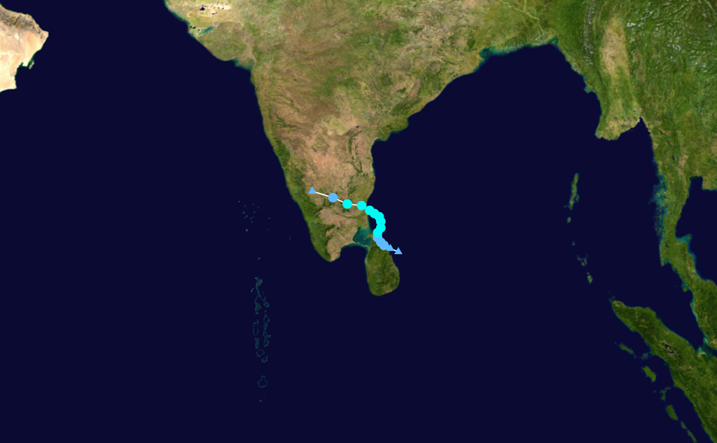
Duration November 25 – November 29 Intensity 85 km/h (50 mph) (3-min), 996 mbar (hPa) Main article: Cyclone Nisha (2008)Late in the morning of November 25, India Meteorological Department satellite imageries, including surface observations from Sri Lanka and coastal stations of Tamil Nadu, indicated that a depression had formed over Sri Lanka in southwest Bay of Bengal. The depression remained nearly stationary and intensified into a deep depression three hours later. The IMD posted a cyclone watch for Tamil Nadu region of India noting that the system was likely to intensify into a cyclonic storm and cross Tamil Nadu coast between Pamban and Nagapattinam by tomorrow night. Very late in the day the IMD mentioned that the deep depression would intensify, however the cyclone watch for Tamil Nadu coast was lowered (or not mentioned) in the bulletin issued. Early on November 26, the deep depression close to Tamil Nadu coast intensified into a cyclonic storm and was named "Nisha". It crossed the coast close to the north of Karaikal between 0530 and 0630 hours IST on November 27. On November 28, JTWC issued their final warning. Nisha headed northwest towards south Karnataka after making landfall in Tamilnadu.[65]
15 people have been killed when Nisha hit northern Sri Lanka on November 25, 2008, causing heavy rains and flooding that reportedly displaced between 60,000 and 70,000 people in Vanni and 20,000 people in Jaffna district.[66] Jaffna recorded the highest rainfall since 1918, of 520.1 mm of rain in last week, with Wednesday’s reading of 389.8 mm, being the highest in nine decades. [67]
189 people have been killed by the heavy rains and floods caused by the Nisha in Tamil Nadu and the death toll is expected to rise.[68][69] Some places have recorded extreme rainfall, notably Orathanadu, Thanjavur District where over 660 mm of rain fell within a period of 24 hours and broke the 65-year old record of highest rainfall registered in 24 hours in Tamil Nadu. In two days, Orathanadu registered 990 mm of rainfall. Previously the highest amount of rainfall in a day was 570 mm registered by Cuddalore on May 18, 1943 .[70] The most affected areas map released by ReliefWeb.[71]
Nisha killed 204 people making it the 4th deadliest storm in 2008 after Cyclone Nargis, Typhoon Fengshen and Hurricane Hanna. Damage is estimated at about 3789 crores i.e. $800 million (USD).[72]
Deep Depression BOB 08
Deep depression (IMD) Tropical storm (SSHS) 

Duration December 4 – December 7 Intensity 55 km/h (35 mph) (3-min), 1004 mbar (hPa) On December 3, an area of low pressure formed over the southern Bay of Bengal within the Intertropical Convergence Zone. The system was well organized with good convection present from the previous 48 hours. On December 4, the India Meteorological Department (IMD) upgraded the area of low pressure to a depression giving it the designation "BOB 08". At that time it was located approximately 650 kilometres (400 mi) south-southwest of Port Blair.[73] That day, the Joint Typhoon Warning Center (JTWC) designated the system as Tropical Cyclone 07B.[74] Early on December 5, the IMD upgraded Depression BOB 08 to a deep depression.[75] On December 7, the IMD reported that BOB 08 weakened into a depression.[76] The depression continued to weaken until it decayed into a remnant low late on the same day.[77]
Season effects
This table lists all the Depressions that developed in the North Indian Ocean during the 2008 season. The meteorological data is taken all from RSMC New Delhi and is rated using their intensity scale.
2008 North Indian Ocean cyclone statistics Storm name Active dates Storm category at peak intensity
Max wind
(mph)
Min. press.
(mbar)
Landfall(s) Damage (millions
USD)
Deaths Where When Wind (mph)
Nargis April 27–May 3 Very severe cyclonic storm 105 962 Ayeyarwady Division, Burma May 2 105 10,000 >146,000 ARB 01 June 3–June 07 Depression 30 994 none none 0 BOB 02 June 16–June 18 Depression 30 1001 Bangladesh June 17 30 unknown 4 BOB 03 August 9–August 10 Land depression 30 1004 Orissa, India August 9 30 unknown 0 BOB 04 September 14–September 19 Deep depression 35 986 Orissa, India September 17 30 unknown 25 ARB 02 October 19–October 23 Deep depression 35 1005 Socotra, Yemen September 16 40 1000 184 Southern Yemen September 17 30 Rashmi October 25–October 27 Cyclonic storm 50 996 Patharghata, Bangladesh October 27 50 unknown 20 Khai Muk November 13–November 16 Cyclonic storm 50 996 Chennai, India November 16 45 3.5 0 Nisha November 25–November 29 Cyclonic storm 65 982 Jaffna, Sri Lanka November 25 45 800 192 Southern Nagapattinam, India November 26 65 BOB 08 December 4–December 8 Deep depression 35 996 Sri Lanka December 7 35 None 0 Season Aggregates 10
DepressionsApril 27–December 8 105 962 10 landfalls >11,800 >146,401 See also
- List of North Indian Ocean cyclone seasons
- 2008 Atlantic hurricane season
- 2008 Pacific hurricane season
- 2008 Pacific typhoon season
- South-West Indian Ocean cyclone seasons: 2007-08, 2008-09
- Australian region cyclone seasons: 2007-08, 2008-09
- South Pacific cyclone seasons: 2007-08, 2008-09
References
- ^ ftp://ftp.met.fsu.edu/pub/weather/tropical/GuamStuff/2008042518-ABIO.PGTW
- ^ http://www.webcitation.org/5XO85b97r
- ^ http://www.webcitation.org/5XPQAjkzn
- ^ http://www.webcitation.org/5XQ3nNFym
- ^ http://www.webcitation.org/5XR3dt6mQ
- ^ http://www.webcitation.org/5XWv3llQa
- ^ http://www.webcitation.org/5XWvIrKQm
- ^ [1][dead link]
- ^ Burmese Storm Toll 'tops 10,000'. BBC News. May 5, 2008. Retrieved on 2008-05-05
- ^ http://reliefweb.int/rw/fullMaps_Sa.nsf/luFullMap/4CD06A41E5CF29538525748E00491BD3/$File/080716_mmr_hpm_part1.jpg?OpenElement&emid=TC-2008-000057-MMR
- ^ "Natural catastrophes and man-made disasters in 2008: North America and Asia suffer heavy losses". Swiss Reinsurance Company Ltd. 21 January 2009. p. 24. http://swissre.com/resources/dd6346004d4e9669ac76eecedd316cf3-sigma2_2009_e.pdf. Retrieved 16 January 2010.[dead link]
- ^ "ABIO10 04-06-08". JTWC. ftp://ftp.met.fsu.edu/pub/weather/tropical/GuamStuff/2008060404-ABIO.PGTW. Retrieved 2008-06-04.
- ^ "IMD Special Tropical Weather Outlook 05-06-08 06z". IMD. http://www.webcitation.org/5YLEJxuI4. Retrieved 2008-06-05.
- ^ "Cwind Advisory 05-06-08 00z". IMD. http://www.webcitation.org/5YLSYgxvs. Retrieved 2008-06-05.
- ^ "Cwind Advisory 05-06-08 03z". IMD. http://www.webcitation.org/5YMxFd8l2. Retrieved 2008-06-06.
- ^ "IMD Special Tropical Weather Outlook 07-06-08 00z". IMD. http://www.webcitation.org/5YS0cC394. Retrieved 2008-06-05.
- ^ a b c d e "Cyclonic Disturbances over the North Indian Ocean during 2008". India Meteorological Department. 2009-02-25. http://www.webcitation.org/5ersiGA0w. Retrieved 2009-02-27.
- ^ "C-Wind Advisory 16-06-2008". India Meteorological Department. 2008-06-16. http://www.webcitation.org/5YcBGMEsX. Retrieved 2009-02-27.
- ^ "C-Wind Advisory 18-06-2008". India Meteorological Department. 2008-06-18. http://www.webcitation.org/5YftErsca. Retrieved 2009-02-27.
- ^ Sampad Mahapatra (June 17, 2008). "Orissa on alert after heavy rainfall". NDTV. http://www.ndtv.com/convergence/ndtv/story.aspx?id=NEWEN20080053305&ch=6/17/2008%208:31:00%20AM. Retrieved April 15, 2009.
- ^ Staff Writer (June 17, 2008). "Orissa sounds alert, army called out in flood-hit Assam district". The Economic Times. http://economictimes.indiatimes.com/News/International_Business/%20Orissa_sounds_alert_army_called_out_in_flood-hit_Assam_district/articleshow/3137468.cms. Retrieved April 15, 2009.
- ^ Staff Writer (June 19, 2009). "Flood alarm in Orissa; river levels rise". Sify. http://sify.com/news/fullstory.php?id=14698116. Retrieved April 15, 2009.
- ^ "IMD Tropical Weather Outlook 09-08-08 12z". IMD. http://www.webcitation.org/5Zx3v0w76. Retrieved 2008-08-11.
- ^ "IMD Tropical Weather Outlook 10-08-08 06z". IMD. ftp://ftp.met.fsu.edu/pub/weather/tropical/New-Delhi/2008081007.DEMS. Retrieved 2008-08-11.
- ^ http://www.webcitation.org/5Zx3v0w76
- ^ http://www.webcitation.org/5bgwta1al
- ^ "IMD CWIND advisory 10-08-08 12z". IMD. http://www.webcitation.org/5ZytFjd1n. Retrieved 2008-08-11.
- ^ "ABIO10 14-09-08 18z". JTWC. ftp://ftp.met.fsu.edu/pub/weather/tropical/GuamStuff/2008091418-ABIO.PGTW. Retrieved 2008-09-16.
- ^ "IMD Special Tropical Weather Outlook 15-09-08 15z". IMD. ftp://ftp.met.fsu.edu/pub/weather/tropical/New-Delhi/2008091517.DEMS. Retrieved 2008-09-16.
- ^ "JTWC TCFA 15-09-08 23z". JTWC. ftp://ftp.met.fsu.edu/pub/weather/tropical/GuamStuff/2008091522-WTIO.PGTW. Retrieved 2008-09-16.
- ^ "IMD Special Tropical Weather Outlook 16-09-08 06z". IMD. ftp://ftp.met.fsu.edu/pub/weather/tropical/New-Delhi/2008091607.DEMS. Retrieved 2008-09-16.
- ^ "JTWC Advisory 16-09-08 15z". JTWC. ftp://ftp.met.fsu.edu/pub/weather/tropical/GuamStuff/2008091615-WTIO.PGTW. Retrieved 2008-09-16.
- ^ "IMD CWind Advisory 7". IMD. http://www.webcitation.org/5asfIBGgz. Retrieved 2008-09-16.
- ^ "JTWC Advisory 16-09-08 21z". JTWC. ftp://ftp.met.fsu.edu/pub/weather/tropical/GuamStuff/2008091621-WTIO.PGTW. Retrieved 2008-09-16.
- ^ "IMD CWind Advisory 14". IMD. http://www.webcitation.org/5avTN4l5G. Retrieved 2008-09-18.
- ^ "IMD CWind Advisory 18". IMD. http://www.webcitation.org/5axpqdffX. Retrieved 2008-09-20.
- ^ a b "IMD Observed Track". IMD. http://www.webcitation.org/5azbAcQVc. Retrieved 2008-09-20.
- ^ "Flash floods in Orissa kill three, affect one million". Thai Indian. http://www.thaindian.com/newsportal/uncategorized/flash-floods-in-orissa-kill-three-affect-one-million-lead_10097205.html. Retrieved 2008-09-17.
- ^ "15 killed as torrential rains lash Uttar Pradesh". Thai Indian. http://www.thaindian.com/newsportal/enviornment/15-killed-as-torrential-rains-lash-uttar-pradesh-lead_10097956.html. Retrieved 2008-09-20.
- ^ "Over 100 fishermen missing in Bay of Bengal". Peoples Daily. http://english.people.com.cn/90001/90778/90858/90863/6500485.html. Retrieved 2008-09-17.
- ^ "20ft waves swamp seaside hotels". Indian Telegraph. http://www.telegraphindia.com/1080918/jsp/bengal/story_9851376.jsp. Retrieved 2008-09-17.
- ^ "IMD CWind Advisory 01". IMD. http://www.webcitation.org/5bghxJEdu. Retrieved 2008-10-19.
- ^ "IMD Special Tropical Weather Outlook 21-10-08 06z". IMD. http://www.webcitation.org/5bjKYuKrl. Retrieved 2008-10-21.
- ^ ftp://ftp.met.fsu.edu/pub/weather/tropical/New-Delhi/2008102206.DEMS
- ^ Jim Andrews (2008-10-22). "TD 03B Heads for Yemen". AccuWeather. http://www.accuweather.com/mt-news-blogs.asp?partner=accuweather&blog=Andrews&pgurl=/mtweb/content/Andrews/archives/2008/10/td_03b_heads_for_yemen.asp. Retrieved 2008-10-25.
- ^ Jim Andrews (2008-10-25). "03B Floods Yemen; Bay of Bengal Cyclone Watch". AccuWeather. http://www.accuweather.com/mt-news-blogs.asp?partner=accuweather&traveler=0&blog=Andrews&pgurl=/mtweb/content/Andrews/archives/2008/10/03b_floods_yemen_sends_moisture_north_to_iraq.asp. Retrieved 2008-10-25.
- ^ [2][dead link]
- ^ "Heavy Flooding in Yemen Report 3". WHO. 2008-10-28. http://www.reliefweb.int/rw/rwb.nsf/db900SID/EGUA-7KUL5K?OpenDocument. Retrieved 2008-10-28.
- ^ Lynn, Jonathan (October 28, 2008). "About 180 dead or missing after floods in Yemen". Reuters. http://www.reuters.com/article/homepageCrisis/idUSLS392519._CH_.2400.
- ^ http://www.webcitation.org/5bqD3dBZw
- ^ "YEMEN Death toll hits 184 in Yemen flooding - Asia News". Asianews.it. 2008-10-28. http://www.asianews.it/index.php?l=en&art=13597&size=A. Retrieved 2010-10-19.
- ^ "ReliefWeb on ARB02". http://reliefweb.int/rw/fullMaps_Sa.nsf/luFullMap/0C32AE50765817C9C12574EF0045E40E/$File/rw_FL_yem081027.gif?OpenElement&emid=FL-2008-000201-YEM. Retrieved 2010-10-19.
- ^ "IMD Observed Track". IMD. http://www.webcitation.org/5buCbH6gZ. Retrieved 2008-10-28.
- ^ "Fifteen killed in Bangladesh storm". Reuters. October 28, 2008. http://www.reuters.com/article/worldNews/idUSTRE49R0L920081028.
- ^ "Five killed as rains wreck havoc in Meghalaya". Zeenews.com. 2008-10-27. http://www.zeenews.com/articles.asp?aid=479331&sid=REG. Retrieved 2010-10-19.
- ^ "Internet Edition". The Daily Star. 2008-10-28. http://www.thedailystar.net/story.php?nid=60723. Retrieved 2010-10-19.
- ^ "Microsoft Word - Cyclonic Storm Rashmi Final Report.doc" (PDF). http://www.imd.gov.in/section/nhac/dynamic/cycRashmi.pdf. Retrieved 2010-10-19.
- ^ Visakhapatnam (November 16, 2008). "Cyclonic storm'Khai Muk' weakens, crosses coast in Nellore". WebIndia. http://news.webindia123.com/news/articles/India/20081116/1105821.html. Retrieved March 1, 2009.
- ^ Staff Writer (November 15, 2008). "Andhra on alert as cyclone threatens coast". Chennai, India: The Hindu. http://www.hindu.com/thehindu/holnus/002200811151601.htm. Retrieved March 1, 2009.
- ^ a b c Staff Writer (November 17, 2008). "7,500 villagers shifted". Chennai, India: The Hindu. http://www.hindu.com/2008/11/17/stories/2008111753510300.htm. Retrieved March 1, 2009.
- ^ a b Staff Writer (November 27, 2008). "Fishermen hit by Khai Muk to get relief". Chennai, India: The Hindu. http://www.hindu.com/2008/11/27/stories/2008112756010300.htm. Retrieved March 1, 2009.
- ^ a b Staff Writer (November 18, 2008). "Cyclone: farm sector bears the brunt". Chennai, India: The Hindu. http://www.hindu.com/2008/11/18/stories/2008111853380300.htm. Retrieved March 1, 2009.
- ^ Staff Writer (November 17, 2008). "Storm causes extensive damage to crops". Chennai, India: The Hindu. http://www.hindu.com/2008/11/17/stories/2008111751540300.htm. Retrieved March 1, 2009.
- ^ Staff Writer (November 17, 2008). "Cyclonic storm dissipates". Chennai, India: The Hindu. http://www.hindu.com/2008/11/17/stories/2008111753860400.htm. Retrieved March 1, 2009.
- ^ http://www.webcitation.org/5cg2DUtJe
- ^ "ReliefWeb ť Document ť Sri Lanka: Allow aid groups to help cyclone victims". Reliefweb.int. http://www.reliefweb.int/rw/rwb.nsf/db900SID/EDIS-7LTQR4?OpenDocument. Retrieved 2010-10-19.
- ^ "Record Rain falls cripple Northern Sri Lanka". Tamileelamnews.com. http://www.tamileelamnews.com/news/publish/tns_10537.shtml. Retrieved 2010-10-19.
- ^ "Deep depression over Bay of Bengal weakens: Met Dept". Chennai, India: Hindu.com. 2008-12-07. http://www.hindu.com/thehindu/holnus/004200812071604.htm. Retrieved 2010-10-19.
- ^ "CM meets Collectors". Expressbuzz.com. 2008-12-07. http://www.expressbuzz.com/edition/story.aspx?Title=CM+meets+Collectors&artid=sgQm60STlv4=&SectionID=vBlkz7JCFvA=&MainSectionID=fyV9T2jIa4A=&SectionName=EL7znOtxBM3qzgMyXZKtxw==&SEO=. Retrieved 2010-10-19.
- ^ "Tamil Nadu / Chennai News : Rain-related death toll rises to 51". Chennai, India: The Hindu. November 28, 2008. http://www.hindu.com/2008/11/28/stories/2008112854260400.htm. Retrieved 2010-10-19.
- ^ "Areas affected by Nisha". http://reliefweb.int/rw/fullMaps_Sa.nsf/luFullMap/3A95CE6C7BB78225C125750F0055CEEB/$File/rwmm_TC_asi081128.gif?OpenElement. Retrieved 2010-10-19.
- ^ "Tamil Nadu / Chennai News : State puts flood damage at Rs.3,789 cr". Chennai, India: The Hindu. 2008-12-12. http://www.hindu.com/2008/12/12/stories/2008121253870400.htm. Retrieved 2010-10-19.
- ^ "IMD Depression BOB 08 Tropical Cyclone Bulletin 01". India Meteorological Department. http://www.webcitation.org/5coFpo2Ln. Retrieved 4 November 2010.
- ^ "JTWC Tropical Cyclone 07B Warning 01". Joint Typhoon Warning Center. http://www.webcitation.org/5co5cnkjX. Retrieved 4 November 2010.
- ^ "IMD Depression BOB 08 Tropical Cyclone Bulletin 05". India Meteorological Department. http://www.webcitation.org/5cpBoXK2L. Retrieved 4 November 2010.
- ^ "IMD Depression BOB 08 Tropical Cyclone Bulletin 15". India Meteorological Department. http://www.webcitation.org/5csxOiP7Z. Retrieved 4 November 2010.
- ^ "IMD Depression BOB 08 Tropical Cyclone Bulletin 18". India Meteorological Department. http://www.webcitation.org/5ctnaFDjI. Retrieved 4 November 2010.
External links
- RSMC Report on Cyclonic Disturbances in html
- India Meteorological Department Cyclone Page
- Cyclonic Storm Rashmi: A Preliminary Report
Tropical cyclones of the 2008 North Indian Ocean cyclone season
IMD Tropical Cyclone Intensity scale D DD CS SCS VSC SC  Book ·
  Category ·
  Portal ·
  WikiProject ·
  Commons
2000–09 North Indian Ocean cyclone seasons Categories:


Wikimedia Foundation. 2010.