- Davington
-
Coordinates: 51°19′08″N 0°53′02″E / 51.319°N 0.884°E
Davington District Swale Shire county Kent Region South East Country England Sovereign state United Kingdom Police Kent Fire Kent Ambulance South East Coast EU Parliament South East England List of places: UK • England • Kent Davington is a suburb of Faversham in Kent, England.
 Stonebridge Pond
The population of Davington parish is approaching 6,000. Davington Priory is a local government ward within the Faversham Town Council and Swale Borough Council areas. Until the civic boundary changes were brought into effect in 2004, and the electoral ward had broadly mirrored the ecclesiastical parish of Davington.
There are three current histories of different aspects of the parish generally available:
- Robert Hackford, The School in an Orchard (Faversham Papers No 16),
- Kenneth Melrose, Davington: Parish & People (Faversham Papers No 52), 1996
- John Burke and Laurence Young, A History of Davington Priory, 2003.
It forms the western section of the town, including Bysing Wood and Bysing Wood fishing lakes. But the ward of Davington also encompasses Luddenham and Oare and other nearby rural areas. The parish's most striking geographical feature is the sharply defined ridge, up which Davington Hill, Brent Hill and Dark Hill travel, with the parish church sitting at its top. The ridge runs south-west to north-east, losing height as it approaches the marshes and sea. Its topography is similar to the ridge upon which Bysing Wood stands further to the west of the area, near Oare.[1]
The parish has large areas of post-war housing developments, as well as industrial estates and complexes along the Oare Road and the Western Link Road. These include Brett's (quarry firm), GIST (business logistics company) and Shepherd Neame Brewery also has a warehouse, as well as in the town centre of Faversham. Before the war and later expansion. The parish was fairly rural and essentially was a cluster of houses around the parish church and school, as well as a few widely distributed farm houses and cottages around. The post-war residential development connected the parish to centre of Faversham.
Davington church is a prominent and much-loved local feature, which stand on top of a ridge above Stonebridge Pond. The Norman Priory Church is dedicated to St Mary Magdalene and St Lawrence the church is the oldest existing building in the Faversham area. Most of its building construction dates from the second half of the twelfth century.[2] Beside it, is a Priory house. This is largely the remains of Davington Priory,[3] which was founded in 1153 for a prioress and her 26 Benedictine nuns. It is well-known for being the home of Bob Geldof who lives in the area.[4]
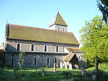 Church of St. Mary Magdalen and St. Lawrence
Other important buildings in the parish include, Davington Farmhouse[5] and Davington Manor.[6]
Davington also had its own light railway. Davington Light Railway. Built in 1916, the 3 mile track was used for passenger traffic mainly. It was also very short-lived and closed in 1919. It linked Davington with the high explosives factories of the Cotton Powder Company and Explosives Loading Company between Uplees and Harty Ferry near Oare.[7]
The parish also has two pubs, Albion Taven (Shepherd Neame)[8] and Brents Tavern.[9] It also has the popular Davington Primary School.
Also incuded within the parish is the Faversham Angling Club Lakes and nearby Oare Gunpowder Works (now a country park). Davington Light Railway.[7]
External links
References
- ^ http://www.faversham.org/pages/standard.aspx?i_PageID=1172
- ^ http://www.britishlistedbuildings.co.uk/en-176003-church-of-st-mary-magdalene-faversham
- ^ http://www.britishlistedbuildings.co.uk/en-176000-davington-priory-faversham
- ^ http://findarticles.com/p/articles/mi_qn4161/is_20010429/ai_n14527020/
- ^ http://www.britishlistedbuildings.co.uk/en-176005-davington-farmhouse-faversham
- ^ http://www.britishlistedbuildings.co.uk/en-175868-davington-manor-faversham
- ^ a b http://www.faversham.org/pages/standard.aspx?i_PageID=15814
- ^ http://www.geograph.org.uk/photo/2042300
- ^ http://www.geograph.org.uk/photo/1268865
Towns and villages in the Borough of Swale in Kent, England 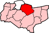 Bapchild · Badlesmere · Bay View · Bobbing · Borden · Boughton Street · Boughton under Blean · Bredgar · Brogdale · Buckland · Chestnut Street · Conyer · Dargate · Davington · Denstroude · Doddington · Dunkirk · Eastchurch · Eastling · Elmley · Faversham · Faversham Without · Goodnestone · Graveney · Halfway Houses · Hartlip · Harty · Heart's Delight, Swale · Hernhill · Highsted · Iwade · Kemsley · Keycol · Kingsdown · Leaveland · Leysdown-on-Sea · Lower Halstow · Luddenham · Lynsted · Milstead · Milton Regis · Minster · Mockbeggar · Murston · Newington · Newnham · Norton · Oad Street · Oare · Ospringe · Oversland · Painters Forstal · Queenborough · Rodmersham Green · Rushenden · Selling · Sheldwich · Shellness · Sheerness · Sittingbourne · Stalisfield Green · Teynham · Throwley · Tonge · Tunstall · Upchurch · Uplees · Warden · Waterham · WhitehillCategories:
- Swale
- Villages in Kent


Wikimedia Foundation. 2010.