- Coppull
-
Coordinates: 53°37′15″N 2°39′41″W / 53.6209°N 2.6615°W
Coppull 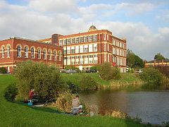
Coppull Mill & Coppull Lodge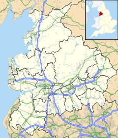
 Coppull
Coppull shown within LancashirePopulation 7,637 (2001 Census) OS grid reference SD562140 Parish Coppull District Chorley Shire county Lancashire Region North West Country England Sovereign state United Kingdom Post town CHORLEY Postcode district PR7 Dialling code 01257 Police Lancashire Fire Lancashire Ambulance North West EU Parliament North West England UK Parliament Chorley List of places: UK • England • Lancashire Coppull is a village and civil parish in Lancashire, England. It is part of the borough of Chorley, lies around 300 feet (91 m) above sea level and has a population of around 7,600. It is bounded by Whittle Brook, Clancutt Brook, the River Yarrow, Eller Brook, Hic-Bibi Brook and Stars Brook. Coppull is located between Chorley and Standish, Greater Manchester, to the east of the A49 road near Charnock Richard.
Coppull was archaically known as Cophulle, Crophull or Crophill, meaning "a cropped hill" or a "hill rising to a peak”.
Contents
History
Coppull was largely believed to have been a settlement formed by the Brigantes, and the area was subsequently occupied by the Romans; the Roman Road from Standish to their camp at Walton-le-Dale passed through the village.
The first mention of "Coppull" came in 1215 as Coppull of Worthington. By 1830 Coppull was a rather unimportant agricultural area of a few cottages, houses and farms, and a small chapel to the east.
After 1850 Coppull grew rapidly, many new rows of houses were built to house coal miners and factory workers. There were many collieries and deep shafts were sunk for the John Pit, Springfield Pit, Blainscough, Hic Bibi, Darlingtons, Ellerbeck, Birkacre and Pearsons mines. Mineral lines carried coal tubs to the main railway. Brickworks at Hic Bibi, Coppull Moor and off Mike Lane used Coppull clay for this industrial boom.
Economy
Coppull expanded greatly along with the rest of Lancashire during the Industrial Revolution of the 18th century. As well as the cotton industry the village is situated on the Lancashire Coalfield. There were several major collieries located in the village during this era with notable collieries being Chisnall Hall (biggest in the area) and Ellerbeck; the latter being the last Chorley pit to close in the late 1980s.
The Coppull Ring Mill is arguably Coppull's most famous landmark. The mill has long since stopped manufacturing but the building has been converted to use in the service industry.
Since the decline in manufacturing and the end of the coal industry the village has been converted into a satellite town for commuters to Chorley and Wigan. Notable industries today include The Yew Tree Dairy, Morris's Bakery and Staveley's egg producer.
Transport
Intersecting the village is the B5251 road, which connects Chorley to the Wigan-Preston Road. The village's closest motorway connections are the M6 Junction 27 at Standish and the M61 Junction 8 at Chorley.
The village was once served by the Blackpool to Liverpool Line stopping at Coppull railway station but this stop was terminated in 1967. Recently there has been a campaign from locals regarding re-opening the station.
The village is also served by two regular Arriva and Stagecoach bus services, with Arriva connecting it to Wigan and Chorley Interchange and Stagecoach connecting it just to Chorley. The local Network Chorley service operates in the village.
Religion
The village has five churches: Coppull Parish C of E Church; St. John the Divine C of E Church; St.Oswald's Roman Catholic Church; Spendmore Lane Methodist Church; and Preston Road Methodist Church.
Sport
Owing to Coppull's coal mining history and proximity to Wigan, the sport of rugby league has had a strong presence in the village. Chorley Panthers is a successful youth and amateur club based at Chisnall playing fields.
External links
Categories:- Geography of Chorley
- Villages in Lancashire
- Civil parishes in Lancashire


Wikimedia Foundation. 2010.