- Columbus Day Storm of 1962
-
Columbus Day Storm of 1962 Surface Analysis of the storm near its peak intensity[1]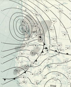
Storm type: Extratropical cyclone Formed: October 3, 1962 Dissipated: October 17, 1962 Maximum
amount:*Unknown Lowest
pressure:960 hPa Damages: $230 million (1962 dollars) Fatalities: 46 Areas affected: Pacific Northwest and British Columbia ^* Maximum snowfall or ice accretion
The Columbus Day Storm of 1962 (otherwise known as the Big Blow, and originated as Typhoon Freda) was an extratropical cyclone that ranked among the most intense to strike the United States Pacific Northwest since at least 1948, likely since the January 9, 1880 "Great Gale" and snowstorm. On a larger scale, the Columbus Day Storm of 1962 is a contender for the title of most powerful extratropical cyclone recorded in the U.S. in the 20th century; with respect to wind velocity, it is unmatched by the March 1993 "Storm of the Century" and the "1991 Halloween Nor’easter" (aka "The Perfect Storm").
Contents
Synoptic history
 Storm trajectory compared to two other important storms hitting the Pacific Northwest in 1981 and 1995
A tropical storm named Freda formed 500 miles/800 km from Wake Island in the central Pacific ocean.[2] The system became an extratropical cyclone as it moved into colder waters and interacted with the jet stream. The low redeveloped explosively off Northern California due to favorable upper level conditions, producing record rainfalls in the San Francisco Bay Area that delayed some games in the 1962 World Series (between the San Francisco Giants and the New York Yankees). The low moved northeastward, and then hooked straight north as it neared southwest Oregon. The storm then raced nearly northward at an average speed of 40 mph (64 km/h) or greater, with the center just 50 miles (80 km) off the Pacific Coast. There was little central pressure change until the cyclone passed the latitude of Astoria, Oregon, at which time the low began to degrade. The center passed over Tatoosh Island, Washington, before landing on Vancouver Island, British Columbia, where it weakened rapidly. As the cyclone moved through Canada a new cyclone formed on its southern periphery, which merged with this cyclone by October 17.[3]
The extratropical wave cyclone deepened to a minimum central pressure of at least 960 hPa (28.35 inHg), and perhaps as low as 958 hPa (28.30 inHg), a pressure which would be equivalent to a Category 3 hurricane on the Saffir-Simpson hurricane scale. Since it was an extratropical cyclone, its wind field was neither as compact nor as strong as a tropical cyclone. All-time record-low land-based pressures (up to 1962) included 969.2 hPa (28.62 inHg) at Astoria, 970.5 hPa (28.66 inHg) at Hoquiam, Washington, and 971.9 hPa (28.70 inHg) at North Bend, Oregon. The Astoria and Hoquiam records were broken by a major storm on December 12, 1995 (966.1 hPa at Astoria)—this event, however, did not generate winds as intense as the Columbus Day storm of 1962.
Wind speed highlights
 Most of these peak gusts were taken at official stations[4]
The peak winds were felt as the storm passed close by on October 12. At Oregon's Cape Blanco, an anemometer that lost one of its cups registered wind gusts in excess of 145 mph (233 km/h); some reports put the peak velocity at 179 mph (288 km/h).
At the Mount Hebo Air Force Station in the Oregon Coast Range, the anemometer pegged at its maximum 130 mph (209 km/h) for long periods—likely at the level of a Category 4 hurricane; damage to the radar domes suggested wind gusts to at least 170 mph (270 km/h). Dome tiles were thrown down the mountainside; the 200 lb (45 kg) chunks tore through entire trees.
At the Naselle Radar Station in the Willapa Hills of southwest Washington, a wind gust of 160 mph (257 km/h) was observed.
In Salem, Oregon a wind gust of 90 mph was observed.
At Corvallis, Oregon, an inland location in the Willamette Valley, 1-minute average winds reached 69 mph (111 km/h), with a gust to 127 mph (204 km/h), before the anemometer was destroyed and the observation tower began flying apart, forcing the abandonment of the station.
Ninety miles (145 km) to the north, at Portland, Oregon's major metropolitan area, measured wind gusts reached 116 mph (187 km/h) at the Morrison Street Bridge.
Many anemometers, official and unofficial, within the heavily stricken area of northwestern Oregon and southwestern Washington were destroyed before winds attained maximum velocity. For example, the wind gauge atop the downtown Portland studios of KGW radio and TV recorded two gusts of 93 mph (150 km/h), just before flying debris knocked the gauge off-line at about 5 p.m.
For the Willamette Valley, the lowest peak gust officially measured was 86 mph (138 km/h) at Eugene. This value, however, is higher than the maximum peak gust generated by any other Willamette Valley windstorm in the 1948–2010 period.
In the interior of western Washington, officially measured wind gusts included 78 mph (126 km/h) at Olympia, 88 mph (142 km/h) at McChord Air Force Base, 100 mph (160 km/h) at Renton at 64 feet (20 m) and 98 mph (158 km/h) at Bellingham. In the city of Seattle, a peak fastest mile of 65 mph (105 km/h) was recorded; this suggests gusts of at least 80 mph (129 km/h). Damaging winds reached as far inland as Spokane.
Wind gusts of 58 mph (93 km/h), the National Weather Service minimum for "High Wind Criteria," or higher were reported from San Francisco, California, to Vancouver, British Columbia.
Impact
In less than 12 hours, over 11 billion board feet (26,000,000 m³) of timber was blown down in northern California, Oregon and Washington combined; some estimates put it at 15 billion board feet (35,000,000 m³). This exceeded the annual timber harvest for Oregon and Washington at the time. This value is above any blowdown measured for East Coast storms, including hurricanes: even the often-cited New England hurricane of 1938, which toppled 2.65 billion board feet (6,000,000 m³), falls short by nearly an order of magnitude.
Estimates put the dollar damage around $230 million to $280 million for California, Oregon and Washington combined, with nearly $200 million occurring in Oregon alone. These figures, in 1962 dollars, are comparable to land-falling hurricanes that occurred within the same time frame (say 1957 to 1961, Audrey, Donna, Carla). The dollar damage adjusted to 2002 for inflation and population/property increase suggest a $3 to $5 billion storm, if not more[citation needed].
The Metropolitan Life Insurance Co. (now MetLife) named the Columbus Day Storm the nation's worst natural disaster of 1962.
 Damage from the storm
In Central and Northern California, all time record rains associated with the cold front caused major flooding and mudslides, particularly in the San Francisco Bay Area. Oakland set an all time calendar day record with 4.52 inches (11.5 cm) of rain on the 13th, as did Sacramento with 3.77 inches (9.6 cm). Over 7 inches (180 mm) of rainfall were recorded in the Bay area.[5]
In the Willamette Valley, it is said that the undamaged home was the exception, with the damaged house being the rule. Livestock suffered greatly to the barn failures: the animals were crushed under the weight of the collapsed structures, a story that was sadly repeated many times throughout the afflicted region. At the north end of the Valley, two 500-foot (150 m) high voltage transmission towers were toppled.
Radio and TV broadcasting were affected in the Portland area. KGW-TV lost its tower at Skyline and replaced the temporary tower with a new one on January 28, 1963. KOIN radio lost one of two AM towers at Sylvan. KPOJ AM-FM lost much of its transmitting equipment, plus one of two towers was left partially standing at Mount Scott. KPOJ-FM was so badly damaged it wouldn't return to the air until February 9, 1963. KWJJ-AM lost one of its towers and a portion of its transmitter building at Smith Lake. KISN-AM also lost a tower at Smith Lake. Seven month old TV station KATU did not receive any damage at its Livingston Mountain site, six miles (10 km) north of Camas, Washington. However, KATU didn't have a generator and power was cut off.
For northwest Oregon, the entire power distribution system had to be rebuilt from the ground up. Some locations did not have power restored for several weeks. This storm became a lasting memory for local power distributors. Indeed, a number of high wind related studies appeared in the years after the storm in attempt to assess the return frequency of such potentially damaging winds.
The state Capitol grounds at Salem, and the state's college campuses, resembled battlefields with heavy losses of trees.
The Campbell Hall tower at Oregon College of Education (now Western Oregon University) in Monmouth crashed to the ground, an event recorded by student photographer Wes Luchau in the most prominent picture-symbol of the storm.
The Oregon State Beavers-Washington Huskies football game went on as scheduled Saturday, October 13 in Portland, in a heavily damaged Multnomah Stadium with no electric scoreboard or clock, no hot showers for the players and the stadium missing much of its roofing. Crews began clearing debris from the grandstand and playing field at about 5 am, and worked right up to the 2 pm kickoff.
East of Salem, the blow destroyed a historic barn that served as a clandestine meeting place by pro-slavery Democratic members of the state Legislature in 1860.
The effects of the Columbus Day storm are still present today. For example, many of the unimproved backcountry roads used by hunters, recreational enthusiasts, and loggers were put in during an intense timber salvage effort aimed at recovering some of the billions of board feet toppled by the gale. Also, the heavy-duty design of the radio towers on Portland's West Hills, with extensive and robust guy cables, is a direct result of the lessons learned by the 1962 catastrophe.
Aftermath
At least 46 fatalities were attributed to this storm, more than for any other Pacific Northwest wind event. Injuries went into the hundreds. In terms of storm-related fatalities for the 20th century, only Oregon's Heppner Flood of 1903 (247 deaths) and Washington's Wellington avalanche of 1910 (96 deaths) caused more. For Pacific Northwest windstorms in the 20th century, the runner up was the infamous October 21, 1934, gale, which caused 22 fatalities, mostly in Washington.
The level of emergency caused by this storm exceeds that of any other Pacific Northwest event in memory. When queried, locals who experienced the storm nearly unanimously tell an account that is both interesting and frightening. The memory is vivid even four decades after the storm. For many, the response was to seek shelter immediately, move away from windows and go into interior rooms or basements.
See also
- Great Gale of 1880
- Extratropical cyclone
- Surface weather analysis
- Windstorm
- Hanukkah Eve Wind Storm of 2006
References
- ^ U. S. Weather Bureau. Daily Weather Maps: October 13, 1962. Retrieved on 2006-11-28.
- ^ Al Sholand. October 12, 1962: Typhoon Freda stormed in to town. Retrieved on 2006-11-28.
- ^ U. S. Weather Bureau. Daily Weather Maps: October 17, 1962. Retrieved on 2006-11-28.
- ^ Wolf Read. The "Big Blow" of Columbus Day 1962. Retrieved on 2006-11-28.
- ^ J. L. Baldwin Weekly Weather and Crop Bulletin. U. S. Department of Commerce., pp. 1.
External links
- Windstorms Brochure (PDF) from the National Weather Service Forecast Office in Portland, Oregon
- Wolf Read's "Storm King" Web site with extensive analysis of every major Pacific Northwest windstorm of the 20th and 21st centuries, with a special section on the Columbus Day Storm
- Photo gallery, NWSFO, Portland
- Images of storm Damage in Marion and Polk County, Oregon from Salem Public Library
Modern history of Oregon (1890–present) Topics 
Events Places People - Terry Baker
- George Chamberlain
- James A. Fee
- David B. Frohnmayer
- Neil Goldschmidt
- Matt Groening
- Mark Hatfield
- Nan Wood Honeyman
- Ken Kesey
- Phil Knight
- Hall S. Lusk
- Tom McCall
- Douglas McKay
- Charles McNary
- Wayne Morse
- Maurine Brown Neuberger
- Norma Paulus
- Steve Prefontaine
- Jack Ramsay
- Barbara Roberts
- James H. Weaver
- History of Oregon's native peoples
- of Oregon to 1806
- of pioneers in Oregon
- of Oregon in modern times
Categories:- Geography of British Columbia
- Natural disasters in Oregon
- Natural disasters in Washington (state)
- 1962 meteorology
- 1962 natural disasters
- 1962 in Oregon
- Pacific Northwest storms


Wikimedia Foundation. 2010.