- Urban neighbourhoods of Sudbury
-
Sudbury — Former city — Downtown Sudbury.
Country Canada 
Province Ontario 
City Greater Sudbury Wards 1, 2, 4, 5, 8, 9, 10, 11, 12 Incorporated (Town) 1893 Incorporated (City) 1930 Dissolved 2000 Government – City Councillors Joe Cimino, Jacques Barbeau, Evelyn Dutrisac, Ron Dupuis, Ted Callaghan, Doug Craig, Frances Caldarelli, Janet Gasparini, Joscelyne Landry-Altmann – Governing Body Greater Sudbury City Council – MPs Claude Gravelle (NDP)
Glenn Thibeault (NDP)– MPPs Rick Bartolucci (Lib)
France Gélinas (NDP)Population (2001)Statistics Canada – Total 92,059 Time zone EST (UTC-5) – Summer (DST) EDT (UTC-4) Postal Code FSA P3A, P3B, P3C, P3E, P3G, P0M Area code(s) 705 This is a list of neighbourhoods in the urban core of Greater Sudbury, Ontario. This list includes only those neighbourhoods that fall within the pre-2001 city limits of Sudbury — for communities within the former suburban municipalities, see the articles Capreol, Nickel Centre, Onaping Falls, Rayside-Balfour, Valley East and Walden.
Contents
Downtown
The Downtown of Sudbury is bounded by Ste-Anne Road/Davidson Street to the north, Douglas Street at Brady/Elgin Street at Howey Drive to the south, Kitchener Street to the east and Alder Street to the west, and includes one of the city's largest concentration of retail businesses and offices.
The downtown core was the city's original neighbourhood.
An urban renewal project in the 1960s saw the downtown Borgia Street neighbourhood demolished in favour of a large shopping mall facility, now known as the Rainbow Centre,[1] a realignment and expansion of Notre-Dame Avenue, and the expropriation of land for Tom Davies Square, the city's modern city hall.[2] Another parcel of municipal land adjacent to the city hall was later donated by the city to the Sudbury Theatre Centre. The city also attracted national press attention in the 1970s for the creation of St. Andrews Place, a unique church facility which incorporated a chapel, retail space and a housing complex for senior citizens.[2]
With retail businesses in the city increasingly locating outside of the downtown core, particularly in the Four Corners, Kingsway and Lasalle Boulevard areas, the city has struggled in recent years to maintain a vibrant downtown. Recent projects have included the creation of Market Square, a farmers' and craft market, the redevelopment of the Rainbow Centre mall, streetscape beautification projects, and the creation of the Downtown Village Development Corporation, a not-for-profit organization that identifies and pursues development opportunities, creates partnerships, and advocates for and promotes initiatives that stimulate business and residential investment in Sudbury’s historic core. At various times, city councillors and community groups have proposed that the city purchase the CPR stockyards west of Elgin Street in order to expand the downtown area, although to date this has not been pursued. The farmers' market is currently being considered as a site for Laurentian University's proposed School of Architecture.
One of Downtown Sudbury's more unusual features is a five-acre park on a hill in the southeast corner of the neighbourhood, centred on a grotto dedicated to Our Lady of Lourdes. The grotto was erected in 1907 on the private estate of Frédéric Romanet du Caillaud, a wealthy, noble, lawyer and writer from Limoges, France who became one of Sudbury's first significant private landowners after moving to the city five years earlier.[2] After Romanet du Caillaud's death, ownership of the site passed to a local businessman's family, and then to a succession of community committees. A pathway depicting the Stations of the Cross was later added to the adjoining parkland in 1958.[3] The site later fell into disrepair, and following a vandalism incident in 1993 it was taken over by the Roman Catholic Diocese of Sault Ste. Marie, which refurbished the park and continues to operate it as a public outdoor shrine.
In 2010, the city announced that it was investigating the process of having the downtown core designated as a heritage district.[4]
Flour Mill
 The Flour Mill - an iconic landmark in Sudbury, Ontario
The Flour Mill neighbourhood is centred on Notre-Dame Avenue and Kathleen Street, immediately north of downtown Sudbury, from Jogues Street to Wilma Street. The neighbourhood around Leslie Street and Mountain Street is known as Primeauville, in honour of a local priest, but is often considered part of the Flour Mill. In French, the community is known as le Moulin-à-Fleur. It is the French Quarter of the city. It should be noticed that the French word "fleur" means here "finest, best, choiciest", and refers to "fleur de farine" (that is, the finest part of the flour). The French name translates therefore correctly as "Flour Mill" and not "Flower Mill". (In fact, it is the English pair "flour"/"flower" that derives from the single medieval French word flor/fleur, already carrying the two meanings. The term "flour" was spelled "flower" in English until the XIX century.[5])
One of the city's first neighbourhoods outside the original settlement, the Flour Mill was historically settled by Franco-Ontarian farmers and labourers. The neighbourhood's most notable surviving building, a large flour mill silo, was operated by the Manitoba and Ontario Flour Mill company. Its other notable buildings include the Catholic parish of St-Jean-de-Brébeuf, situated at the corner of Notre-Dame Avenue and Kathleen Street, and the École catholique Sacré-Coeur, situated on the former site of Collège Sacré-Coeur.
From the early 1900s into the 1960s, the neighbourhood was frequently flooded by spring runoff into Junction Creek.[6] In some years, the flooding was so severe that it extended into downtown. Due to improved flood control practices, however, the neighbourhood has not experienced a significant Junction Creek flood since the 1960s.
Following the mill's closure, there were frequent proposals to demolish the silo and redevelop the property. These proposals, and their attendant controversy, continued until the silo was designated a city heritage property in 1990. The historic home of the mill's foreman was converted to a community museum, the Flour Mill Museum, in 1974.
In 2007, the neighbourhood has faced controversy as its local business improvement association has battled a city plan to widen Notre-Dame Avenue, the major city arterial which passes through the neighbourhood, to six lanes to accommodate expanded traffic. The business association also launched a neighbourhood beautification plan, including adding an "avenue of trees" to Notre-Dame, new benches and community banners, and the construction of a waterpark facility in the neighbourhood's O'Connor Park.
In August 2007, the city's Northern Life community newspaper published two articles calling attention to an abandoned cement factory just off a hiking trail near the neighbourhood, which had been used as an illegal dumping ground for garbage and chemicals.[7] The factory's owners, Alexander Centre Industries, pledged to clean up the site a few days after the first article appeared, indicating that the facility had been abandoned for so long that nobody currently employed by the company even knew it existed until the controversy hit the press.[8]
The residential Cambrian Heights neighbourhood extends northward from the Flour Mill along Cambrian Heights Drive.
Bell Park
The Bell Park neighbourhood, more commonly referred to as the Hospital area, centred on John and Paris Streets running north to Worthington Crescent, south to Science North, west to Regent Street and eastward to Mcrea Island. One of the oldest neighbourhoods in the city with homes dating from the late 1800s to the 1940s. The grand arts and crafts movement mansion of William J. Bell for whom this neighbourhood is named is in the heart of this area. It is currently home to the Art Gallery of Sudbury. The Bell Park is part of his former estate land, donated to the city by the family in 1926. The two gazebos in the park are named after William Bell and his wife, Katherine Bell. Two former mayors of the city are also honoured in the park grounds: the park's amphitheatre is named for Grace Hartman and the boardwalk connecting the park to the nearby Science North site in the former Bell Grove, along the Lake Ramsey shoreline is named in honour of Jim Gordon. A monumental sculpture to the city's mining heritage also overlooks the park site from a hill at the northern boundary of the park. This neighbourhood also includes the area known as Kingsmount, centring on Kingsmount Blvd and Killarney Ave., as well as the York Highlands.
New Sudbury
The New Sudbury area, centred on Lasalle Boulevard running East-West and Barry Downe Road running North-South. In French, it is known as le Nouveau-Sudbury. The area includes a mix of commercial development along Lasalle, such as the New Sudbury Centre, the largest shopping mall in Northern Ontario,[9] and residential properties on most of the streets leading north and south. This community is home to the Adanac Ski Hill and Rotary Park, as well as Timberwolf Golf Course, Collège Boréal and Cambrian College. The area also includes the smaller neighbourhoods of Nickeldale, which is home to Sudbury's only Moraine, Barry Downe, Don Lita and Lebel.
The small industrial area immediately surrounding the Sudbury Junction railway station may also be known as Sudbury Junction.
South End
The South End of Sudbury includes the urban neighbourhoods of Robinson,[10] Lockerby, Moonglo and Lo-Ellen. The centre of the area is the Four Corners, a major commercial shopping district centred on the intersection of Regent Street, Paris Street and Long Lake Road. The Southridge Mall, located on the southeast quadrant of the Four Corners, is currently undergoing a major expansion.
The South End is currently one of the fastest-growing areas of the city, with significant commercial and residential development taking place especially in the Algonquin Road area. A significant controversy in recent years has involved the city's construction of a rock tunnel to increase the neighbourhood's sewer capacity — after a $4 million budget shortfall in the project, the city imposed a temporary levy on new development in the area.
Highway 17, the main route of the Trans-Canada Highway, passes through the South End along the Southwest Bypass. The government of Ontario has announced that the Highway 17 route will be converted to a freeway within the next decade; the highway already follows a freeway route further west in the Walden area. In preparation for the freeway conversion, the intersection of Highway 17 and Long Lake Road has been converted to a full interchange, which opened in 2008.
There are two public high schools, Lo-Ellen Park and Lockerby, and one Catholic high school, St. Benedict, in the South End area. There are also two French-language schools in the area: École publique Hélène-Gravel and École Catholique St-Denis.
The more rural McFarlane Lake and Long Lake areas may also be grouped with the South End, or may be treated as distinct neighbourhoods. McFarlane Lake once was home to a French school and a French church, both named St-Mathieu.
West End
The West End is the area located immediately west of downtown, up to the westernmost end of the original city limits, south to Byng Street. Primarily residential in character, with some commercial areas within, the neighbourhood is centred on the intersection of Regent and Victoria Streets, it is home to Queens Athletic Park, with its track & field oval that becomes a skating oval over the winter, and home to one of the old water towers built in the 1940s, part of a pair bookending Old Sudbury. It includes the smaller neighbourhoods of Elm West and Little Britain.
Minnow Lake
Minnow Lake is a residential area centred on Bancroft Drive between the Kingsway (Municipal Road 55) and Lévesque Street. The area east of Second Avenue is sometimes known as Adamsdale. Minnow Lake also includes the eastern half of the Howey Drive area; the small neighbourhood centred on Howey Drive between Minnow Lake and downtown is known as Brodie. There is an actual Minnow Lake that can be seen from Bancroft Drive, Bellevue Street and Howie Drive. The lake contains a couple of rocky islands: Du Caillaud Island and Romanet Island. Minnow Lake has is home to the Carmichael Arena and its skateboard park. There are also scenic trails around the lake and up the nearby rocky hills. There are three elementary schools in Minnow Lake: Adamsdale Public School, Pius XII Catholic School and École St-Pierre.
Donovan/Northern Heights
Centred on Frood Road northwest of downtown, Donovan refers to the area immediately surrounding the intersection of Frood, Kathleen and Beatty, which was built in the 1930s on top of the original Sudbury dump. While Northern Heights refers to the newer neighbourhood built in the 1970s to the north between Rio Road and St-Roch Lane on unused land.
The area's narrow lots and lane ways give it a distinctive feel. After WWII, the area was settled by many European immigrants, mainly from Ukraine, Poland, Finland and the former republic of Yugoslavia. Each of these ethnic groups founded community halls in the Donovan.
Gatchell
This area is south west of downtown, nestled between the West End and Copper Cliff's industrial area, centred on Lorne Street between the Big Nickel and Martindale Road. The slag heaps framing this neighbourhood are in the process of being turned into forested green hills, disguising many decades of slag dump build-up, 300m high. This area has small 30-foot (9.1 m) lots, built mostly in the 1920s through 1940s. There are also a large number of rental apartments in the neighbourhood. The community is still very much a 'working class" neighbourhood, though many of the homes in the area have been restored. The area was settled by Italian immigrants, who helped found the local parish, St. Anthony.
The community has four public elementary schools and three Catholic elementary schools.
The age of the community has a provided a number of smaller shops and services conveniently scattered throughout. It is also accessible to the shopping either downtown or along the junction of Paris and Regent Streets, where there are several shopping centres and "category killer" box stores.
The community is home to the Gatchell indoor swimming pool. The Junction Creek in this area is undergoing a transformation as the Trans-Canada Trail is being constructed through the vacant lands along its banks. The neighbourhood's primary feature is 'Delki' Dozzi Park, a park and sports complex that defines almost the entire northern boundary of the neighbourhood. The park was named after a prominent Italian-Canadian, local politician, Delchi Dozzi.
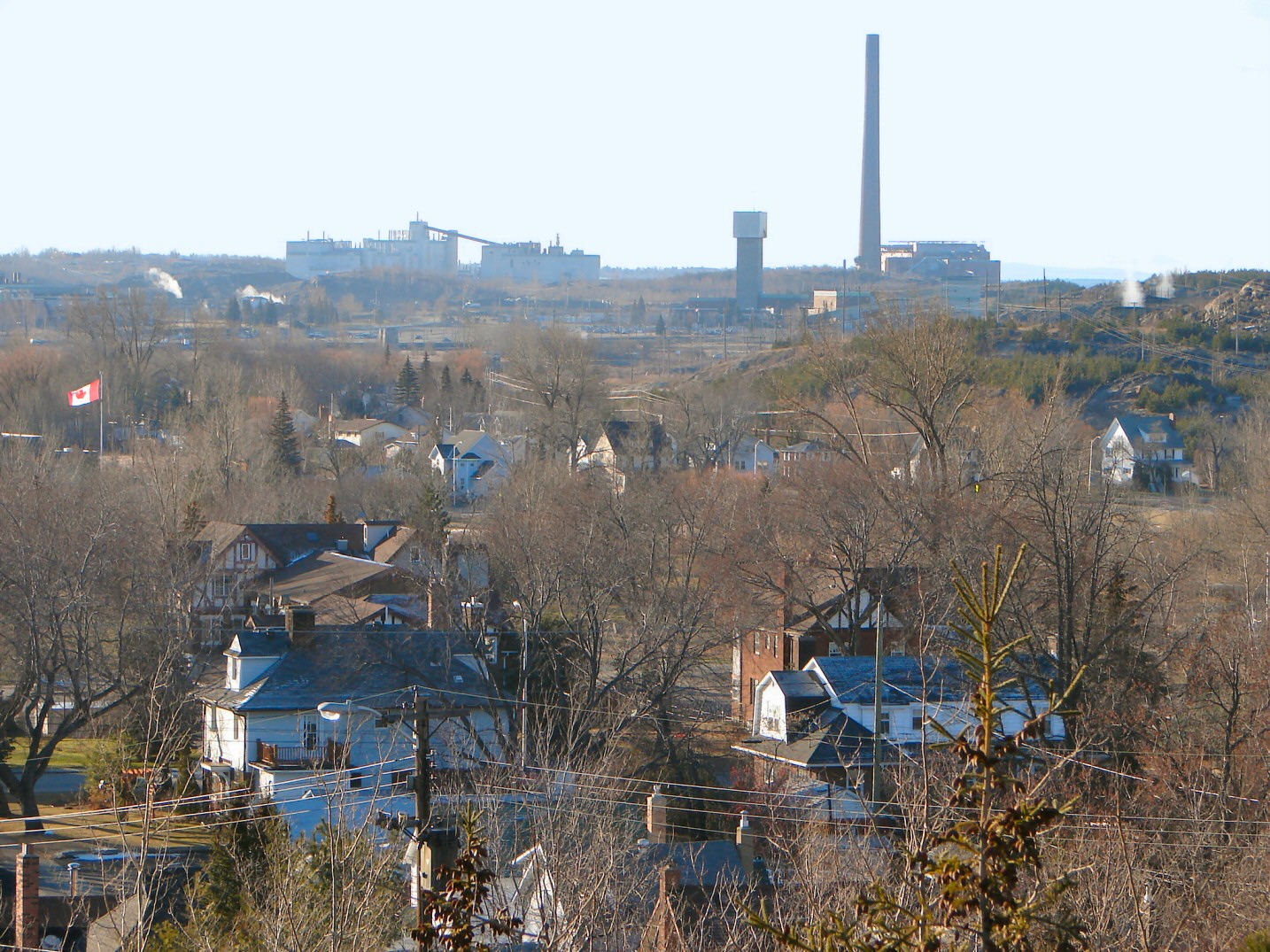
Copper Cliff
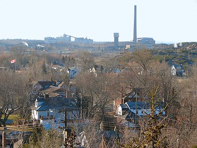 Copper Cliff is in the heart of the nickel mining industry.
Copper Cliff, an area centred on Godfrey Drive and Creighton Road running south to Regional Road 55, was incorporated as a separate company town in 1901, and for a time was in fact larger than the neighbouring community of Sudbury. However, Sudbury had surpassed Copper Cliff in population by 1930 when it was reincorporated as a city. The city of Sudbury attempted to annex Copper Cliff a number of times over the next 40 years, but was rebuffed by the Ontario Municipal Board because the city's desire to gain municipal taxation rights over Inco's mining facilities in the community was deemed incompatible with federal and provincial taxation rules around the mining industry.[2] The neighbourhood was eventually annexed by the city in 1973 as part of the provincially mandated municipal restructuring which resulted in the creation of the Regional Municipality of Sudbury.
However, in many respects it continued to be treated as a distinct community, rather than as part of the city — for example, postal service in Copper Cliff was never integrated into the city's urban forward sortation areas. Instead, Copper Cliff retained a rural P0M postal code.
Vale Inco's operations in the city are headquartered in the Copper Cliff area. Most notably, Copper Cliff is the location of the Inco Superstack, the tallest chimney in the Western Hemisphere, which towers over Inco's main smelter facility.
A local community museum, the Copper Cliff Museum, is located on the site of the very first homestead in what is now Copper Cliff.
The community is now located in Ward 2 on Greater Sudbury City Council, along with the former town of Walden. The location on the south western edge of old Sudbury gives it ready access to the Fielding Bird Sanctuary and Fielding Park along Kelley Lake, to the south west.
This area also includes the micro neighbourhood of Little Italy nestled at the base of the Inco Superstack, centred on Diorite Street and Craig Street. The Societá italiana di Copper Cliff (Italian Club) is one of the oldest social clubs in the area.
References
- ^ [1]
- ^ a b c d C.M. Wallace and Ashley Thomson, Sudbury: Rail Town to Regional Capital. Dundurn Press, 1993. ISBN 1550021702.
- ^ Our Lady of Lourdes Shrine, Diocese of Sault Ste. Marie.
- ^ "Heritage district proposed for downtown". Northern Life, August 6, 2010.
- ^ Etymology of the word flour.
- ^ [2]
- ^ "Beauty and the beast: Ruins in the wilderness". Northern Life. 2007-08-01. http://www.northernlife.ca/News/LocalNews/2007/08-01-07-trailTOP.asp?NLStory=08-01-07-trailTOP. Retrieved 2007-08-15.
- ^ "Owner will clean up Flour Mill eyesore". Northern Life. 2007-08-13. http://www.northernlife.ca/News/LocalNews/2007/08-10-07-cleanup.asp?NLStory=08-10-07-cleanup. Retrieved 2007-08-15.
- ^ [3]
- ^ "Robinson Subdivision". Geographical Names Data Base. Natural Resources Canada. http://geonames.nrcan.gc.ca/search/unique_e.php?id=FCLHZ&output=xml. Retrieved 2011-07-21.
External links
Neighbourhoods in Greater Sudbury, Ontario Old City of Sudbury • Capreol • Nickel Centre • Onaping Falls • Rayside-Balfour • Valley East • Walden • WanupCategories:- Neighbourhoods in Greater Sudbury


Wikimedia Foundation. 2010.