- New Jersey Route 10
-
"NJ 10" redirects here. NJ 10 may also refer to New Jersey's 10th congressional district.
Route 10
Mount Pleasant Avenue 
Route information Maintained by NJDOT Length: 23.51 mi[1] (37.84 km) Existed: 1927 – present Major junctions West end:  US 46 in Roxbury Township
 US 202 in Morris Plains
 I-287 in Hanover Township
East end: 
 CR 577 / CR 677 in West Orange
Highway system New Jersey State Highway Routes
Interstate and US←  US 9W
US 9WRoute 11  →
→Route 10 is a 23.51 mi (37.84 km) state highway in the northern part of the U.S. state of New Jersey. It runs from an intersection with U.S. Route 46 in Roxbury Township, Morris County east to County Route 577/County Route 677 (Prospect Avenue) in West Orange, Essex County. Route 10 is a major route through northern New Jersey that is lined with two shopping districts in Ledgewood and East Hanover/Livingston featuring many shopping centers and large commercial outlets. It is a four-lane highway for most of its length with the exception of the easternmost part of the route. Route 10 features intersections with many major roads including Route 53 and U.S. Route 202 in Morris Plains and Interstate 287 in Hanover Township.
Route 10 was designated in 1927 to run from Jersey City to Dover, following the former Newark and Mount Pleasant Turnpike west of Newark. The route continued east from its present-day routing on current County Route 577, Park Avenue, County Route 508, and Route 7 to end at U.S. Route 1/9 at the Tonnele Circle. An alignment of Route 10 farther to the north of its current alignment in Essex County was proposed in 1952; however, it was never constructed with the route being designated to its present alignment a year later. Since 1953, Route 10 has seen improvements that eliminated the Ledgewood Circle at the western terminus in 1998 and improved safety along the portion of the route in Hanover and East Hanover Townships in the mid 2000s.
Contents
Route description
Morris County
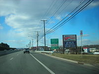 Route 10 westbound approaching Ridgedale Avenue in East Hanover
Route 10 begins at U.S. Route 46 in the Ledgewood section of Roxbury Township at the former Ledgewood Circle, heading to the southeast on a four-lane divided highway with some jughandles.[1] The road heads through commercial areas, passing by the Ledgewood Mall, the Roxbury Mall, and many other businesses.[2] The route enters Randolph Township, where the road becomes less commercial in nature and passes Randolph Lake, interchanging with County Route 617 (Sussex Turnpike). Past this interchange, Route 10 crosses over Mine Hill, where the route is flanked by dense hardwood forest.[1][2] The route crosses County Route 513 (Dover-Chester Road), skirting several residential neighborhoods and passing by the County College of Morris past that intersection, with businesses along the road becoming more frequent again. Route 10 widens to six lanes route and then runs through the southwestern corner of Denville before heading into the Mt. Tabor section of Parsippany-Troy Hills.[1] The route then forms the border between Parsippany-Troy Hills to the north and Morris Plains to the south, interchanging with Route 53 and crossing U.S. Route 202. The route fully enters Parsippany-Troy Hills again before crossing into Hanover Township, coming to an interchange with Dryden Way, where the route widens to eight lanes. Past Dryden Way, Route 10 features an interchange with Interstate 287 and narrows to four lanes.[1]
The road heads through the Whippany section of Hanover Township, which is moderately commercial. Here, it interchanges with County Route 511 (Parsippany Road) at milepost 14.20 and passes by the Whippany Railway Museum.[1][2] Route 10 crosses into East Hanover Township at the crossing of Whippany Brook.[1] Along Route 10 in East Hanover, there are newer shopping plazas anchored by 'big box' retail outlets, along with the older strip malls with a variety of individual shops.[2]
Essex County

Route 10 crosses the Passaic River into Livingston, Essex County, where it becomes Mt. Pleasant Avenue, a road that is lined with many businesses. The route comes to the Livingston Circle, a realigned traffic circle, with County Route 508 (W. Northfield Avenue) and County Route 609 (Eisenhower Parkway).[1][2] Past this traffic circle, the divided highway becomes a four-lane undivided road with some businesses and homes along the road. The route crosses County Route 527 (Livingston Avenue) and narrows to two lanes a short distance past that intersection. The route enters West Orange at the point it crosses Nance Road.[1] In West Orange, Route 10 ends at the Prospect Avenue intersection where radio station WFME is located. At this intersection, County Route 577 heads east on Mt. Pleasant Avenue and north on Prospect Avenue while County Route 677 (signed as County Route 577 Spur) heads south on Prospect Avenue.[1][2]
History
The Newark and Mount Pleasant Turnpike was established along the present-day alignment of Route 10 east of Dover on March 12, 1806, existing as a turnpike until before 1833.[3] Route 10 was designated in 1927 to run from Jersey City west to Route 6 (now U.S. Route 46) west of Dover, passing through Newark.[4][5] This routing of Route 10 followed its current alignment and ran east along present-day County Route 577, Mt. Pleasant Avenue, and Park Avenue to Newark, where it followed County Route 508 and Route 7 to U.S. Route 1/9 at the Tonnele Circle in Jersey City.
In 1952, Route 10 was designated to run along a new, never-built alignment farther to the north, running through Belleville, Bloomfield, Glen Ridge, Montclair, West Orange, and along the Livingston/Roseland border, roughly along much of the routing of present-day County Route 611 (Eagle Rock Avenue), and following its current alignment through Morris County to Ledgewood. A spur of the route was also planned in 1952 to run from Montclair south to Orange.[6] A year later, in the 1953 New Jersey state highway renumbering, Route 10 was defined onto its current alignment, with its eastern terminus moved to Prospect Avenue in West Orange.[7] In 1998, the Ledgewood Circle at the western terminus of the route was replaced with a signalized T-intersection.[8] In the mid 2000s, a $11.5 million project was undertaken to improve safety on the portion of Route 10 in Hanover and East Hanover Townships by widening existing lanes and adding turning lanes to the road.[9]
Major intersections
County Location Mile[1] Destinations Notes Morris Roxbury Township 0.00 US 46Western terminus, former Ledgewood Circle Randolph Township 1.90  CR 617 (Sussex Turnpike)
Interchange 4.01  CR 513 (Dover-Chester Road)
7.19  CR 665 north (Salem Road)
Interchange Parsippany-Troy Hills Township / Morris Plains 10.66  Route 53
Interchange 11.44 US 202 (Littleton Road)Hanover Township 12.22 Dryden Way Interchange 13.00 I-287Exit 39 (I-287) 14.20  CR 511 (Parsippany Road)
Interchange Essex Livingston Township 18.74 
 CR 508 east (West Northfield Avenue) / CR 609 (Eisenhower Parkway)
Livingston Circle 20.14  CR 527 (Livingston Avenue)
West Orange Township 23.51 CR 577 / CR 677 south (Prospect Avenue)Eastern terminus 1.000 mi = 1.609 km; 1.000 km = 0.621 mi See also
 U.S. Roads portal
 New Jersey portal
References
- ^ a b c d e f g h i j k "New Jersey Route 10 straight line diagram". New Jersey Department of Transportation. http://www.state.nj.us/transportation/refdata/sldiag/00000010__-.pdf. Retrieved 2008-06-05.
- ^ a b c d e f Google, Inc. Google Maps – overview of New Jersey Route 10 (Map). Cartography by Google, Inc. http://maps.google.com/maps?f=d&saddr=route+10+and+route+46+ledgewood+nj&daddr=Mt+Pleasant+Ave%2FNorth+St%2FRT-10+to:40.806273,-74.370232+to:route+10+and+prospect+avenue+west+orange+nj&hl=en&geocode=%3BFW1KbwIdEa-P-w%3B%3B&mra=dpe&mrcr=0&mrsp=2&sz=12&via=1,2&sll=40.822124,-74.331779&sspn=0.114835,0.219727&ie=UTF8&ll=40.849138,-74.465332&spn=0.229576,0.439453&t=h&z=11. Retrieved 2009-01-01.
- ^ "CHAPTER XI. TRAVEL AND TRANSPORTATION—TURNPIKES—THE MORRIS CANAL—RAILROADS.". RootsWeb.com. http://www.rootsweb.ancestry.com/~njmorris/munsellhistory/h-chpt11.htm. Retrieved 2009-01-03.
- ^ State of New Jersey, Laws of 1927, Chapter 319.
- ^ Williams, Jimmy and Sharon. "1927 New Jersey Road Map". 1920s New Jersey Highways. http://www.jimmyandsharonwilliams.com/njroads/1920s/images/1927_routes.gif. Retrieved 2008-10-08.
- ^ State of New Jersey, Laws of 1952, Chapter 289.
- ^ 1953 renumbering. New Jersey Department of Highways. http://en.wikisource.org/wiki/1953_New_Jersey_state_highway_renumbering. Retrieved July 31, 2009.
- ^ Balston, Mottel. "A SHORT HISTORY OF ROXBURY TOWNSHIP, MORRIS COUNTY, NEW JERSEY". RoxburyNewJersey.com. http://www.roxburynewjersey.com/history.htm. Retrieved 2009-01-02.
- ^ "Lettiere cuts ribbon on Route 10 congestion relief program in Morris County". New Jersey Department of Transportation. November 26, 2003. http://www.state.nj.us/transportation/about/press/2003/112603.shtm. Retrieved 2009-01-02.
External links
Categories:- Transportation in Essex County, New Jersey
- Transportation in Morris County, New Jersey
- State highways in New Jersey


Wikimedia Foundation. 2010.