- Country Hills, Calgary
-
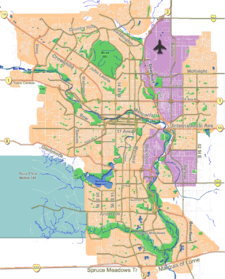
Country Hills — Neighbourhood — Location of Country Hills in Calgary
Coordinates: 51°08′37″N 114°04′20″W / 51.14361°N 114.07222°W Country  Canada
Province  Alberta
City  Calgary
Quadrant NW Ward 3 Established 1990 Government[1] – Administrative body Calgary City Council – Alderman Jim Stevenson Elevation 1,105 m (3,625 ft) Population (2006)[2] – Total 3,705 – Average Income $70,237 Website Country Hills Community Association Country Hills is a residential neighbourhood in the north-west quadrant of Calgary, Alberta. It is bounded to the north by the Country Hills Boulevard, to the south by Beddington Trail and to the east by Harvest Hills Boulevard. To the south-west, it is bordered by the Country Hills golf course and the West Nose Creek. The new community of Country Hills Village is located in the north-east of the neighbourhood.
Country Hills was established in 1990. It is represented in the Calgary City Council by Ward 3 Alderman Jim Stevenson.[3]
Contents
Demographics
In 2006 the neighbourhood had a population of 3,705, with an additional 1,269 living in Country Hills Village.[4] Residents in this community had a median household income of $70,237 in 2000, and there were 7.4% low income residents living in the neighborhood.[1] As of 2000, 18.7% of the residents were immigrants. A proportion of 9.5% of the buildings were condominiums or apartments, and 6.8% of the housing was used for renting.[2] Country Hills Library serves this community. It is located at 11950 Country Village Link N.E. in Cardel Place.
See also
References
- ^ a b City of Calgary (2004). "Ward 3 Profile". http://www.calgary.ca/docgallery/bu/cns/community_social_statistics/ward_3_profile.pdf. Retrieved 2007-05-10.
- ^ a b City of Calgary (2006). "Country Hills Community Statistics". http://www.calgary.ca/docgallery/bu/cns/community_social_statistics/country_hills.pdf. Retrieved 2007-05-10.
- ^ Federation of Calgary Communities. "Country Hills Community". http://www.calgaryarea.com/nw/countryhills/countryhills.htm. Retrieved 2007-05-10.
- ^ City of Calgary (2006). "Community Population Comparison". http://www.calgary.ca/DocGallery/BU/cityclerks/popcomparisonbycomm.pdf. Retrieved 2007-05-10.
External links

Hidden Valley Panorama Hills Coventry Hills Sandstone Valley 
Harvest Hills  Country Hills

Sandstone Valley Beddington Heights Aurora Business Park Coordinates: 51°08′37″N 114°04′20″W / 51.14361°N 114.07222°W
Categories:- Neighbourhoods in Calgary
- Calgary stubs
Wikimedia Foundation. 2010.