- History of surface weather analysis
The history of surface weather analysis concerns the timetable of developments related to surface weather analysis. Initially a tool of study for the behavior of storms, surface weather analyses became a work in progress to explain current weather and as an aid for short term
weather forecasting . Initial efforts to create surface weather analyses began in the mid-nineteenth century by usingsurface weather observation s to analyzeisobars ,isotherms , and display temperature and cloud cover. By the mid-twentieth century, much more information was being placed upon thestation model s plotted on weather maps and surface fronts, per theNorwegian cyclone model , were being analyzed worldwide. Eventually, observation plotting went from a manual exercise to an automated task for computers and plotters. Surface analysis remains a manual and partiallysubjective exercise, whether it be via hand and paper, or via a workstation.Nineteenth century
[
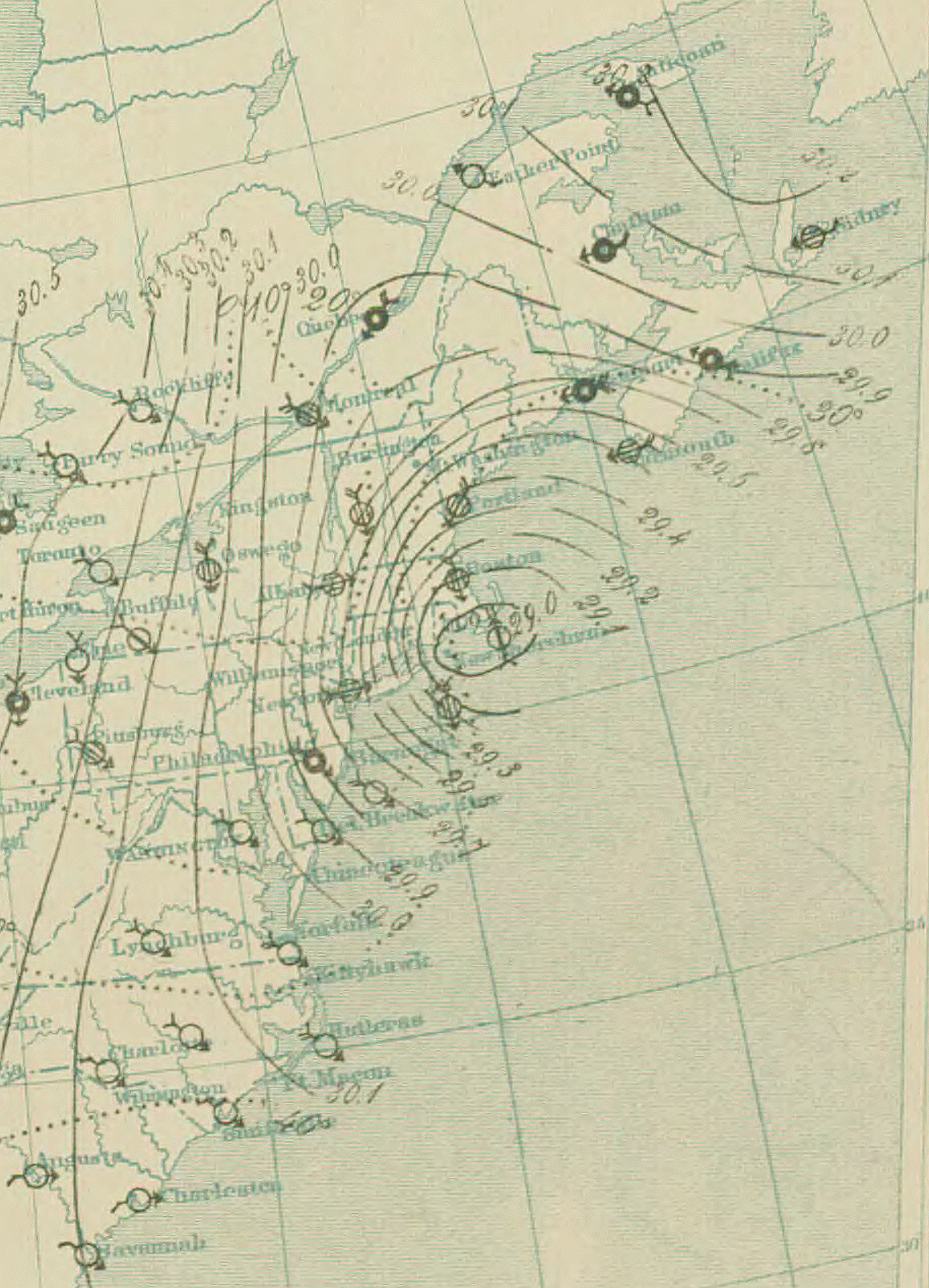
thumb|200px|right|Surface analysis ofGreat Blizzard of 1888 on March 12, 1888 at 10 pm] The use of weather charts in a modern sense began in the middle portion of the 19th century. Weather map pioneers include William Redfield, William Reid, Elias Loomis,Eric R. Miller. [http://docs.lib.noaa.gov/rescue/mwr/061/mwr-061-07-0189.pdf American Pioneers in Meteorology.] Retrieved on2007-04-18 .] and Sir Francis Galton, who created the first weather maps in order to devise a theory on storm systems. [Human Intelligence. [http://www.indiana.edu/~intell/galton.shtml Francis Galton.] Retrieved on2007-04-18 .] The invention of thetelegraph in 1845 made it possible to gather weather information from multiple distant locations quickly enough to preserve its value for real-time applications. The Smithsonian Institution developed its network of observers over much of the central and eastern United States between the 1840s and 1860s once Joseph Henry took the helm. [Frank Rives Millikan.Smithsonian Institution . [http://www.si.edu/archives/ihd/jhp/joseph03.htm Joseph Henry: Father of the Weather Service.] Retrieved on2006-10-22 .] Beginning in 1849, the Smithsonian started producing surface analyses on a daily basis using the 150 stations in their network. [National Oceanic and Atmospheric Administration . [http://www.weather.gov/pa/history/timeline.php Evolution of the National Weather Service.] Retrieved on2006-10-22 .] TheU.S. Army Signal Corps inherited this network between 1870 and 1874 by an act of Congress, and expanded it to the west coast soon afterwards. Three times daily, all stations would telegraph in their observations to the central office which would then plot the information on a map upon whichisobars , or lines of equal pressure, would be drawn which would identify centers of high and low pressure, as well assquall line s. [NOAA . [http://celebrating200years.noaa.gov/foundations/weather/#army General Myer: Establishing a Legacy of Weather Service.] Retrieved on2007-05-05 .] At first, all the data on the map was not taken at exactly the same time in the early days of these analyses because of a lack of time standardization. The first attempts at time standardization took hold in the Great Britain by 1855. However, in the United States, standard time did not come to pass until 1883, whentime zone s started to come into use across America for railroad use. The entire United States did not finally come under the influence of time zones until 1905, whenDetroit finally established standard time. [WebExhibits. [http://webexhibits.org/daylightsaving/d.html Daylight Saving Time.] Retrieved on2007-06-24 .]The earliest surface analyses from the United States featured a map of the continental U.S. with indications of cloud cover and wind direction arranged on an early form of what has become a
station model . A general indication of the weather for various cities around the country was also included on the bottom of the map. Within a short time, the Signal Corps added a tables showing eight-hour pressure change, 24-hour temperature change, relative humidity, and 24-hour precipitation. The Signal Office also added a general discussion of synoptic weather features and forecast, before adding isobars and isotherms onto the maps. By the end of 1872, the maps had established the format it would use until the introduction of frontal analysis. [NOAA Central Library. [http://docs.lib.noaa.gov/rescue/dwm/data_rescue_daily_weather_maps_bak.html U.S. Daily Weather Maps Project.] Retrieved on2007-05-10 .] By the 20th century, most of the weather-related functions under the U. S. Signal Corps branched off into a new civilian agency known as the U. S. Weather Bureau, the forerunner of today'sNational Weather Service .Internationally, other countries followed the lead of the United States, in regards to taking simultaneous weather observations, starting in 1873. [
NOAA . [http://celebrating200years.noaa.gov/foundations/weather/#expand An Expanding Presence.] Retrieved on2007-05-05 .] Other countries then began preparing surface analyses. InAustralia , the first weather map showed up in print media in 1877. [Bureau of Meteorology . [http://www.bom.gov.au/lam/climate/levelthree/analclim/earlym.htm Australia's First Weathermen.] Retrieved on2006-10-22 .]Japan 's Tokyo Meteorological Observatory, the forerunner of theJapan Meteorological Agency , began constructing surface weather maps in 1883. [Japan Meteorological Agency . [http://www.jma.go.jp/jma/en/History/indexe_his.htm History.] Retrieved on2006-10-22 .]Twentieth century
[
 thumb|right|Different_
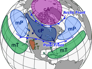
air mass es which affect North America, as well as other continents, tend to be separated by frontal boundaries] The use of frontal zones on weather maps did not appear until the introduction of theNorwegian cyclone model in the late 1910s, despite Loomis' earlier attempt at a similar notion in 1841. [David M. Schultz. " [http://www.cimms.ou.edu/~schultz/sanders/sanders.pdf Perspectives on Fred Sanders's Research on Cold Fronts] ", 2003, revised, 2004, 2006, p. 5. Retrieved on2006-07-14 .] Since the leading edge of air mass changes bore resemblance to themilitary front s ofWorld War I , the term "front" came into use to represent these lines. [Bureau of Meteorology . [http://www.bom.gov.au/info/ftweather/page_6.shtml Air Masses and Weather Maps.] Retrieved on2006-10-22 .]Despite the introduction of the Norwegian
cyclone model just after World War I, the United States did not formally analyze fronts on surface analyses untilAugust 1 , 1941, just before the WBAN Analysis Center opened in downtownWashington, D.C. . [United States Weather Bureau . [http://docs.lib.noaa.gov/rescue/dwm/1941/19410731.djvu Daily Weather] Retrieved on
2008-01-22 .] [United States Weather Bureau . [http://docs.lib.noaa.gov/rescue/dwm/1941/19410801.djvu Daily Weather] Retrieved on
2008-01-22 .] [Hydrometeorological Prediction Center . [http://www.hpc.ncep.noaa.gov/html/historyNMC.shtml A Brief History of the Hydrometeorological Prediction Center.] Retrieved on2007-05-05 .] The effort to automate map plotting began in the United States in 1969, [ESSA. [http://www.ncep.noaa.gov/officenotes/NOAA-NPM-NCEPON-0001/013FD50A.pdf Prospectus for an NMC Digital Facsimile Incoder Mapping Program.] Retrieved on2007-05-05 .] with the process complete in the 1970s.Hong Kong completed their process of automated surface plotting by 1987. [Hong Kong Observatory . [http://www.weather.gov.hk/wservice/tsheet/computer.htm The Hong Kong Observatory Computer System and Its Applications.] Retrieved on2007-05-05 .] By 1999, computer systems and software had finally become sophisticated enough to allow for the ability to underlay on the same workstation satellite imagery, radar imagery, and model-derived fields such as atmospheric thickness and frontogenesis in combination with surface observations to make for the best possible surface analysis. In the United States, this development was achieved when Intergraph workstations were replaced by n-AWIPS workstations. [Hydrometeorological Prediction Center . [http://www.hpc.ncep.noaa.gov/html/Accomplish99/Accomplish99.html Hydrometeorological Prediction Center 1999 Accomplishment Report.] Retrieved on2007-05-05 .]Twenty-First century
[

United States onOctober 21 ,2006 .] By 2001, the various surface analyses done within the National Weather Service were combined into the Unified Surface Analysis, which is issued every six hours and combines the analyses of four different centers.David M. Roth . Hydrometeorological Prediction Center. [http://www.hpc.ncep.noaa.gov/sfc/UASfcManualVersion1.pdf Unified Surface Analysis Manual.] Retrieved on2006-10-22 .] Recent advances in both the fields ofmeteorology andgeographic information system s have made it possible to devise finely tailored products that take us from the traditional weather map into an entirely new realm. Weather information can quickly be matched to relevant geographical detail. For instance, icing conditions can be mapped onto the road network. This will likely continue to lead to changes in the way surface analyses are created and displayed over the next several years. [Saseendran S. A., Harenduprakash L., Rathore L. S. and Singh S. V. [http://www.gisdevelopment.net/application/environment/conservation/envm0004.htm A GIS application for weather analysis and forecasting.] Retrieved on2007-05-05 .]References
Wikimedia Foundation. 2010.