- Mount Blackburn
-
For the mountain by this name in Antarctica, see Mount Blackburn (Antarctica).
Mount Blackburn 
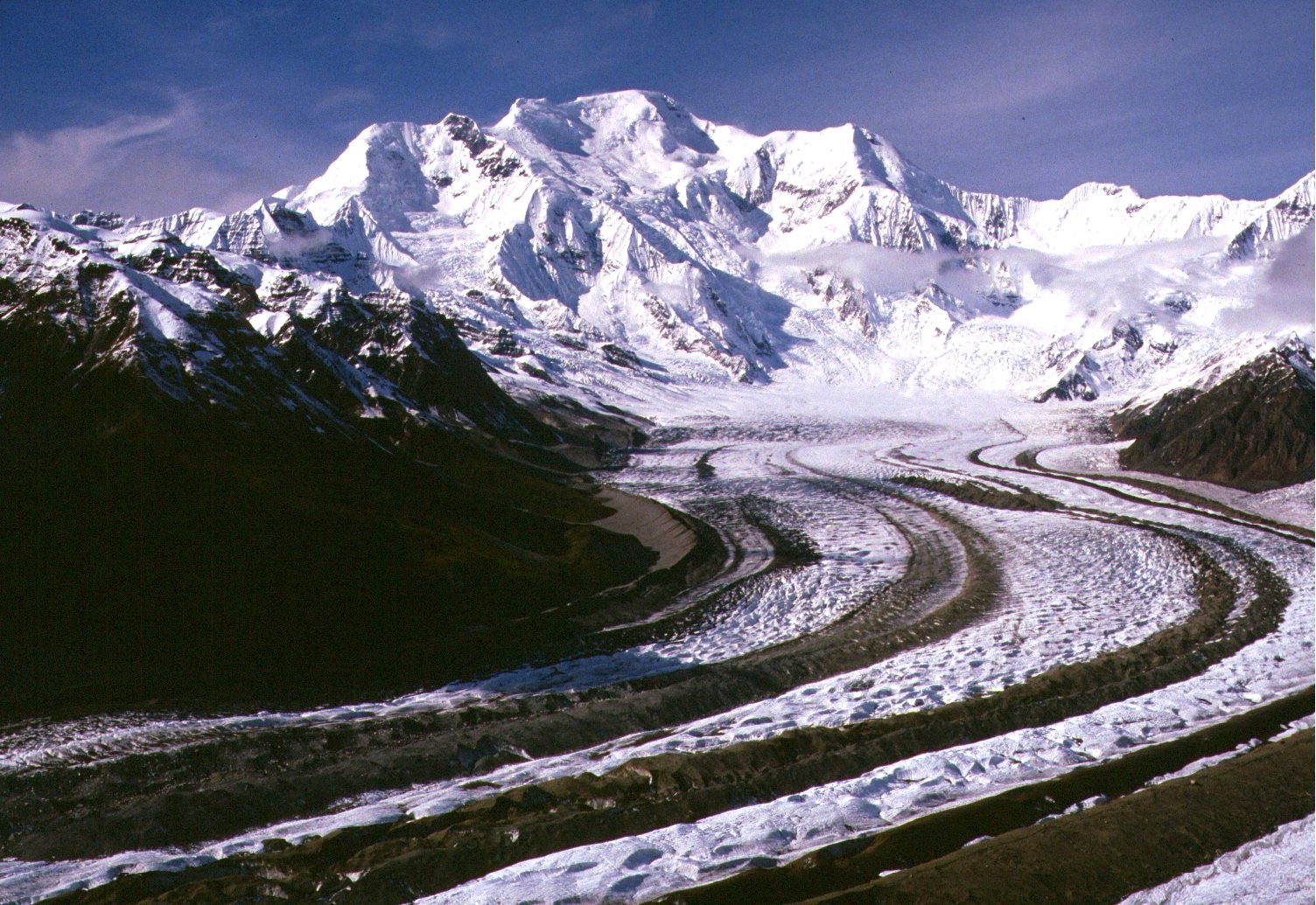
Mount Blackburn from the southeast, looking up the Kennicott GlacierElevation 16,390 ft (4,996 m) Prominence 11,634 ft (3,546 m)
Ranked 50thListing Ultra
Mountain peaks of AlaskaLocation Location in Alaska
 Mount Blackburn
Location Wrangell-St. Elias National Park and Preserve, Alaska, USA Range Wrangell Mountains Coordinates 61°43′54″N 143°25′59″W / 61.73167°N 143.43306°WCoordinates: 61°43′54″N 143°25′59″W / 61.73167°N 143.43306°W Topo map USGS McCarthy C-7 Geology Type Shield volcano Age of rock 3.4 to 5 million years Climbing First ascent 1958 (true summit) Gilbert, Wahlstrom, Gmoser, Bitterlich, and Blumer Easiest route North Ridge: snow/glacier climb Mount Blackburn is the highest peak in the Wrangell Mountains of Alaska in the United States. It is the fifth highest peak[1] in the United States and the twelfth highest peak in North America. The mountain is an old, eroded shield volcano, the second highest volcano in the United States behind Mount Bona and the fifth highest in North America. It was named in 1885 by Lt. Henry T. Allen of the U.S. Army after Joseph Clay Stiles Blackburn, a U.S. senator from Kentucky.[2] It is located in the heart of Wrangell – St. Elias National Park, the largest national park in the country.
The mountain's massif is covered almost entirely by icefields and glaciers, and is the principal source of ice for the Kennicott Glacier, which flows southeast over 20 miles (32 km) to just above the town of McCarthy. The mountain also contributes a large volume of ice to the north-flowing Nabesna Glacier and the Kuskulana Glacier system.
Mount Blackburn is a large, dramatic peak, with great local relief and independence from higher peaks. Its west face drops over 11,000 ft (3,350 m) to the Kuskulana Glacier in less than 4 horizontal miles (6 km). Its other faces drop 8,000–10,000 ft (2,440–3,050 m), all in less than 8 miles. The toe of the Kuskulana Glacier, less than 12 miles from the summit, lies at an elevation of 2,400 ft (730 m), giving a rise of 14,000 ft (4,270 m). While these figures speak to the peak's relief, one measure of its independence is that it is the 50th most topographically prominent peak in the world.[3]
The western of Blackburn’s two summits is the mountain’s highpoint, a fact that was not understood until the 1960s when the then new USGS maps were published. The first ascent of the west peak, and hence Mount Blackburn, was done on May 30, 1958 by Bruce Gilbert, Dick Wahlstrom, Hans Gmoser, Adolf Bitterlich, and Leon Blumer via the North (also called the Northwest) Ridge. This team made the first ascent of Blackburn, but did not even know it at the time due to the incorrect identification of the highpoint. In fact Blumer’s article in the 1959 American Alpine Journal is titled “Mount Blackburn – Second Ascent.”
 The Nabesna Glacier, with Mount Blackburn and its two summits at right; Atna Peaks is the twin summit left of center
Contents
Other subfeatures
Kennedy Peak, or East Blackburn, 16,286 ft (4,964 m), is the eastern summit and the one that was originally thought to be the highest point. The first ascent of this summit was made in 1912 by Dora Keen and George Handy via the Kennicott Glacier (on the south side of the mountain) and East Face. This heady exploit was ahead of its time. Dora Keen, driven by a deep desire for the climb, solicited miners from the nearby Kennecott Copper Mines, and forged a route up the heavily crevassed East Face to the East Peak, but did not traverse over to the West Peak. Keen went on to write a famous article for the Saturday Evening Post titled, “First up Mount Blackburn.” In 1912, Keen and Handy thought they were on Blackburn’s highest point.
Today's standard route on the peak is the 1958 ascent route, the North (or Northwest) Ridge, which is approached from the Nabesna Glacier, on the north side of the mountain, opposite from Keen and Hardy's route. The route starts from an airstrip on the glacier at an altitude of 7,200 feet (2,200 m). It is a moderate climb by Alaskan standards (Alaska Grade 2).
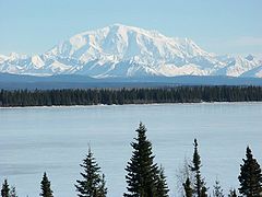 Mount Blackburn from the west, looking across Willow Lake
See also
- 4000 meter peaks of Alaska
- 4000 metre peaks of Canada
- 4000 meter peaks of North America
- 4000 meter peaks of the United States
- Mountain peaks of Alaska
- Mountain peaks of Canada
- Mountain peaks of North America
- Mountain peaks of the United States
- List of volcanoes in the United States of America
Notes
- ^ This is not counting the North Summit of Mount McKinley, which is sometimes counted as an independent peak and sometimes not.
- ^ "USGS GNIS: Mount Blackburn". http://geonames.usgs.gov/pls/gnispublic/f?p=gnispq:3:::NO::P3_FID:1399171. Retrieved March 8, 2007.
- ^ "Peaklist.org: 50 Most Prominent Peaks on Earth". http://www.peaklist.org/WWlists/WorldTop50.html. Retrieved March 9, 2007.
References
- Wood, Michael; Coombs, Colby (2001). Alaska: A Climbing Guide. Mountaineers Books. ISBN 0-89886-724-X.
- Richter, Donald H.; Danny S. Rosenkrans and Margaret J. Steigerwald (1995). Guide to the Volcanoes of the Western Wrangell Mountains, Alaska. USGS Bulletin 2072. http://www.nps.gov/wrst/naturescience/guide-to-the-wrangell-volcanoes.htm.
- Winkler, Gary R. (2000). A Geologic Guide to Wrangell—Saint Elias National Park and Preserve, Alaska: A Tectonic Collage of Northbound Terranes. USGS Professional Paper 1616. ISBN 0-607-92676-7. http://pubs.usgs.gov/pp/p1616/.
- Richter, Donald H.; Cindi C. Preller, Keith A. Labay, and Nora B. Shew (2006). Geologic Map of the Wrangell-Saint Elias National Park and Preserve, Alaska. USGS Scientific Investigations Map 2877. http://pubs.usgs.gov/sim/2006/2877/.
Categories:- Volcanoes of Alaska
- Mountains of Alaska
- Shield volcanoes
- Subduction volcanoes
- Landforms of Valdez–Cordova Census Area, Alaska
- Wrangell–St. Elias National Park and Preserve


Wikimedia Foundation. 2010.