- Subtropical cyclone
-
A subtropical cyclone is a weather system that has some characteristics of a tropical and an extratropical cyclone. As early as the 1950s, meteorologists were unclear whether they should be characterized as tropical or extratropical cyclones. They were officially recognized by the National Hurricane Center in 1972. Subtropical cyclones began to receive names from the official tropical cyclone lists in the Atlantic Hurricane Basin and the southwest Indian ocean.
There are two definitions currently used for subtropical cyclones. Across the north Atlantic and southwest Indian ocean, they require central convection fairly near the center and a warming core in the mid-levels of the troposphere. Across the eastern half of the northern Pacific, they require a mid-tropospheric cyclone to cut off from the main belt of the westerlies and only a weak surface circulation. Subtropical cyclones have broad wind patterns with maximum sustained winds located farther from the center than typical tropical cyclones, and have no weather fronts linked into their center.
Since they form from initially extratropical cyclones which have colder temperatures aloft than normally found in the tropics, the sea surface temperatures required for their formation are lower than the tropical cyclone threshold by 3°C (5°F), lying around 23 °C (73 °F). This also means that subtropical cyclones are more likely to form outside the traditional bounds of the hurricane season.
Contents
History of term
Throughout the 1950s and 1960s, the term semi-tropical and quasi-tropical were used for what would become known as subtropical cyclones.[1] The term subtropical cyclone merely referred to any cyclone located in the subtropical belt near and just north of the horse latitudes. Intense debate ensued in the late 1960s, after a number of hybrid cyclones formed in the Atlantic Basin. In 1972, the National Hurricane Center (NHC) finally designated these storms as subtropical cyclones in real-time,[2] and updated the hurricane database to include subtropical cyclones from 1968 through 1971. The whimsical term "neutercane" was coined by Bob Bundgaard for small subtropical cyclones which formed from mesoscale features, and the NHC began issuing public statements during the 1972 Atlantic hurricane season employing that classification. This name was not noted as controversial in contemporary news reports, but it was dropped less than a year later. Recent articles, published after the year 2000, have suggested that the name "neutercane" was considered sexist in the 1970s, but there do not appear to be any published reports from that period making this claim.[3]
Naming
In the North Atlantic basin, subtropical cyclones were initially named from the NATO phonetic alphabet list in the early to mid-1970s.[2] In the intervening years of 1975–2001, subtropical storms were either named from the traditional list and considered tropical in real-time, or used a separate numbering system. Between 1992 and 2001, two different numbers were given to subtropical depressions or subtropical storms, one for public use, the other one for NRL and NHC reference. For example, Hurricane Karen in 2001 was initially known as Subtropical Storm One as well as AL1301 (or 13L for short).[4] In 2002, the NHC began giving numbers to subtropical depressions and names to subtropical storms from the same sequence as tropical cyclones. From 2002 onwards, Subtropical Depression 13L would be known as Subtropical Depression Thirteen instead. Hurricane Gustav of 2002 was the first Subtropical Storm to receive a name but became tropical shortly after naming. Subtropical Storm Nicole, from the 2004 Atlantic hurricane season was the first subtropical storm that did not become tropical since the policy change. A subtropical storm from the 2005 Atlantic hurricane season also did not become tropical, but was not named since it was not recognized until post-season analysis.[5] In the southern Indian ocean, subtropical cyclones are also named once winds reach tropical storm, or gale, force.[6]
Formation
Subtropical cyclones form in a wide band of latitude, mainly south of the 50th parallel in the northern hemisphere.[7] Due to the increased frequency of cyclones which cut off from the main belt of the westerlies during the summer and fall, subtropical cyclones are significantly more frequent across the North Atlantic than the northwestern Pacific ocean.[8] In the eastern half of the north Pacific ocean and north Indian ocean, the older subtropical cyclone definition term is still used, which requires a weak circulation forming underneath a mid to upper-tropospheric low which has cut off from the main belt of the westerlies during the cold season (winter). In the case of the north Indian ocean, the formation of this type of vortex leads to the onset of monsoon rains during the wet season.[9] In the southern hemisphere, subtropical cyclones are regularly observed across southern portions of the Mozambique Channel.[6]
Most subtropical cyclones form when a deep cold-core extratropical cyclone drops down into the subtropics. The system becomes blocked by a high latitude ridge, and eventually sheds its frontal boundaries as its source of cool and dry air from the high latitudes diverts away from the system. Temperature differences between the 500 hPa pressure level, or 5,900 meters (19,400 ft) above ground level, and the sea surface temperatures initially exceed the dry adiabatic lapse rate, which causes an initial round of thunderstorms to form at a distance east of the center. Due to the initial cold temperatures aloft, sea surface temperatures usually need to reach at least 20 °C (68 °F) for this initial round of thunderstorms. The initial thunderstorm activity moistens up the environment around the low, which destabilizes the atmosphere by reducing the lapse rate needed for convection. When the next shortwave or upper level jet streak (wind maximum within the jet stream) moves nearby, convection reignites closer to the center and the system develops into a true subtropical cyclone. The average sea surface temperature that helps lead to subtropical cyclogenesis is 24 °C (75 °F).[10] If the thunderstorm activity becomes deep and persistent, allowing its initial low level warm core to deepen, tropical cyclogenesis is possible.[7]
Transition from extratropical
By gaining tropical characteristics, an extratropical low may transit into a subtropical depression or storm. A subtropical depression/storm may further gain tropical characteristics to become a pure tropical depression or storm, which may eventually develop into a hurricane, and there are at least two cases of tropical storms transforming into a subtropical storm (Hurricane Klaus in 1984 and Tropical Storm Allison in 2001) .[11] Generally, a tropical storm or tropical depression is not called subtropical while it is becoming extratropical, after hitting either land or colder waters. This transition normally requires significant instability through the atmosphere, with temperature differences between the underlying ocean and the mid-levels of the troposphere requiring over 40 °C, or 72 °F, of contrast in this roughly 5,900 meters (19,400 ft) layer of the lower atmosphere. The mode of the sea surface temperatures that subtropical cyclones form over is 23 °C (73 °F).[10]
Characteristics
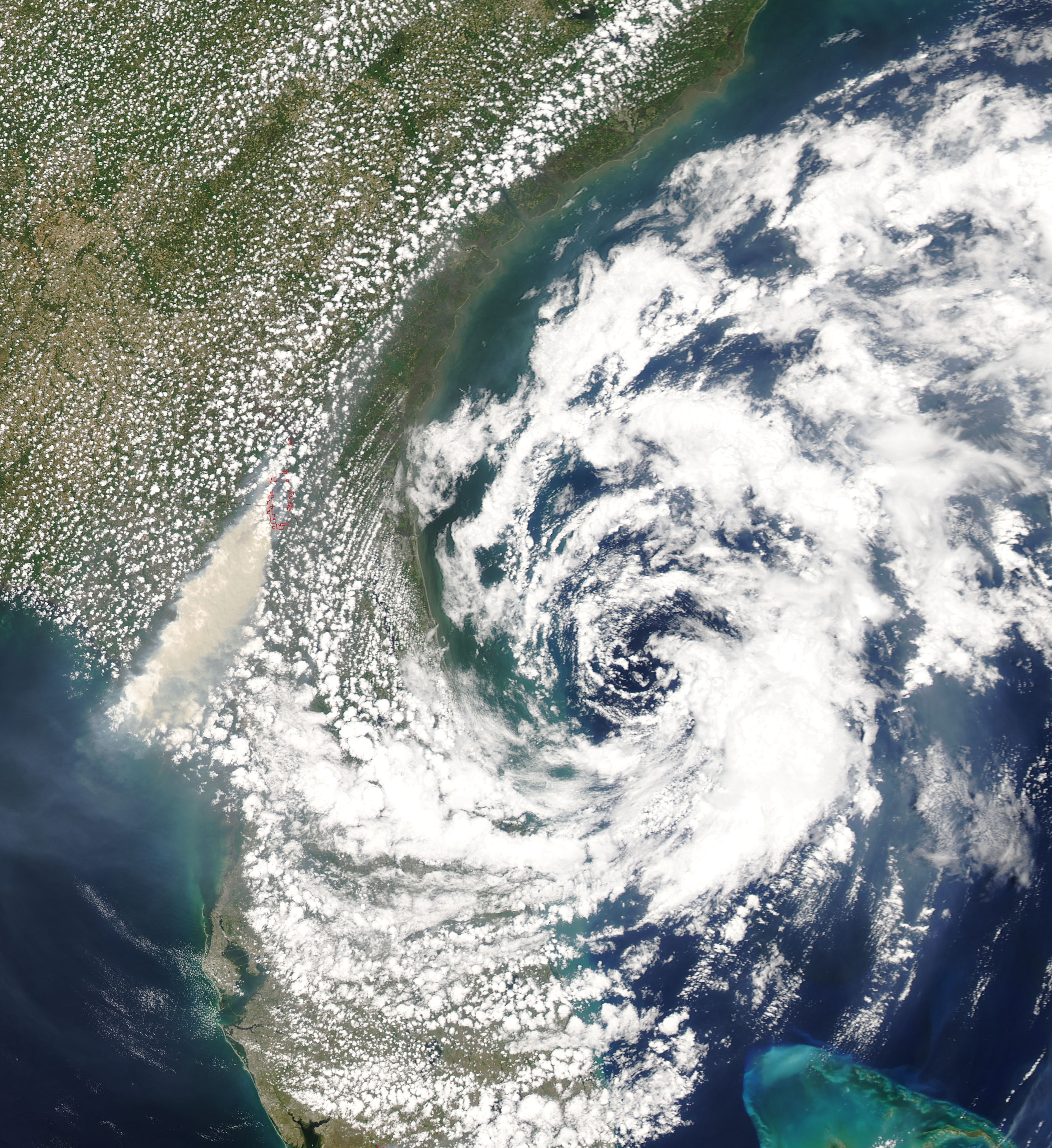
 1991 Perfect Storm becoming subtropical
These storms can have maximum winds extending farther from the center than in a purely tropical cyclone and have no weather fronts linking directly to the center of circulation. The maximum recorded wind speed for a subtropical storm is 33 m/s (119 km/h, 65 knots, or 74 mph), also the minimum for a hurricane. In the Atlantic Basin, the United States NOAA classifies subtropical cyclones similarly to their tropical cousins, based on maximum sustained surface winds. Those with winds below 18 m/s, 65 km/h, 35 knots, or 39 mph are called subtropical depressions, while those at or above this speed are referred to as subtropical storms.[12]
Subtropical cyclones are also more likely than tropical cyclones to form outside of a region's designated hurricane season. Examples include Subtropical Storm Ana (which became Tropical Storm Ana) in mid-April of the 2003 hurricane season and Subtropical Storm Andrea in early May and Subtropical Storm Olga (which became Tropical Storm Olga) in mid-December of the 2007 Atlantic hurricane season.[11] Diagrams which depict a cyclone's phase depict subtropical cyclones with a shallow warm core and as asymmetric systems, similar to tropical cyclones which have begun the transition to an extratropical cyclone.[13]
Types
Upper-level low
The most common type of subtropical storm is an upper-level cold low with circulation extending to the surface layer and maximum sustained winds generally occurring at a radius of about 160 kilometers (99 mi) or more from the center. In comparison to tropical cyclones, such systems have a relatively broad zone of maximum winds that is located farther from the center, and typically have a less symmetric wind field and distribution of convection.[14]
Mesoscale low
A second type of subtropical cyclone is a mesoscale low originating in or near a frontolyzing zone of horizontal wind shear, also known as a dying frontal zone, with radius of maximum sustained winds generally less than 50 kilometers (31 mi). The entire circulation may initially have a diameter of less than 160 kilometers (99 mi). These generally short-lived systems may be either cold core or warm core, and in 1972 this type of subtropical cyclone was referred to as a "neutercane".[15]
Kona low
 November 4, 1995 Kona LowMain article: Kona low
Kona lows are deep cyclones that form during the cool season of the central Pacific ocean. A definition change in the term during the early 1970s makes categorization of the systems more complex, as many kona lows are extratropical cyclones, complete with their own weather fronts. Those across the northeast Pacific ocean consider them subtropical cyclones as long as a weak surface circulation is present.[9] Kona is a Hawaiian term for leeward, which explains the change in wind direction for the Hawaiian Islands from easterly to southerly when this type of cyclone is present.[16]
See also
- Extratropical transition technique
- Subtropical Cyclones Australia
Cyclones and Anticyclones of the world Types Annual anticyclones Polar high – Siberian High – Azores High (Bermuda/North Atlantic) – North American High (Canadian/Greenland) – South Atlantic High (St.Helena) – North Pacific High – South Pacific High – Scandinavian High – Mascarene High (Indian) – Australian High – Antarctic HighAnnual cyclones References
- ^ David B. Spiegler (1973). Many times, subtropical cyclones have a small warm core. Reply. Monthly Weather Review, April 1973, p. 380. Retrieved on 2008-04-20.
- ^ a b R. H. Simpson and Paul J. Hebert (1973). Atlantic Hurricane Season of 1972. Monthly Weather Review, April 1973, pp. 323–332. Retrieved on 2008-06-14.
- ^ Weatherwise (2006). Heldref Publications. March/April 2006, p. 64.
- ^ James Franklin (2001). Subtropical Storm One Public Advisory from 2001. National Hurricane Center Retrieved on 2007-05-05.
- ^ Jack Beven and Eric S. Blake (2006). Unnamed Subtropical Storm. National Hurricane Center. Retrieved on 2007-05-05.
- ^ a b World Meteorological Organization (2006). TROPICAL CYCLONE OPERATIONAL PLAN FOR THE SOUTH-WEST INDIAN OCEAN: 2006 Edition. pp. I-3, I-9. Retrieved on 2009-02-28.
- ^ a b Chris Landsea. Subject: A6) What is a sub-tropical cyclone? National Hurricane Center. Retrieved on 2008-06-14.
- ^ Mark A. Lander (2004). 7A.5 Monsoon Depressions, Monsoon Gyres, Midget Tropical Cyclones, TUTT Cells, and High Intensity After Recurvature: Lessons Learned From Use of Dvorak's Techniques in the World's Most Prolific Tropical-Cyclone Basin. American Meteorological Society. Retrieved on 2009-02-28.
- ^ a b S. Hastenrath (1991). Climate Dynamics of the Tropics. Springer, pp 244. ISBN 9780792313465. Retrieved on 2009-02-29.
- ^ a b David Mark Roth (2002-02-15). "A Fifty year History of Subtropical Cyclones". Hydrometeorological Prediction Center. http://www.hpc.ncep.noaa.gov/research/roth/Subpreprint.pdf. Retrieved 2006-10-04.
- ^ a b National Hurricane Center (2008). Atlantic Hurricane Database (HURDAT). Retrieved on 2009-03-09.
- ^ National Hurricane Center (2009). Glossary of NHC terms. Retrieved on 2007-05-05.
- ^ Robert Hart (2003). Cyclone Phase Analysis and Forecast: Help Page. EUMeTrain. Retrieved on 2009-03-01.
- ^ National Hurricane Center (2009). Glossary of NHC Terms. Retrieved on 2009-02-07.
- ^ Neal Dorst (2007). Subject: A18) What is a neutercane? Hurricane Research Division. Retrieved on 2009-02-07.
- ^ Ian Morrison and Steven Businger (2002). SYNOPTIC STRUCTURE AND EVOLUTION OF A KONA LOW. University of Hawaii. Retrieved on 2007-05-22.
External links
Categories:- Tropical cyclone meteorology
- Midlatitude weather
- Types of cyclone


Wikimedia Foundation. 2010.