- Mount Clarence, Western Australia
-
Mount Clarence
Albany, Western Australia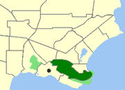
Location of Mount Clarence within AlbanyPopulation: 758 (2006 Census)[1] Postcode: 6330 Area: 2.5 km² (1.0 sq mi) Location: 2 km (1 mi) from Albany LGA: City of Albany State District: Albany Federal Division: O'Connor Suburbs around Mount Clarence: Centennial Park Mira Mar Middleton Beach Albany Mount Clarence Port Albany Albany Port Albany Port Albany Coordinates: 35°01′30″S 117°53′38″E / 35.025°S 117.894°E
Mount Clarence is an inner suburb of Albany, Western Australia, between the Albany city centre and Middleton Beach. Its Local Government Area is the City of Albany, and over three-quarters of its land area is either parkland or forest, including Albany's Heritage Park. Mount Clarence was gazetted as a suburb in 1979.[2]
Contents
Geography
Mount Clarence is bounded by Middleton Road to the north, Marine Drive to the east and south and the eastern boundary of Albany's town centre to the west. Most of the suburb's population of 758 persons[1] is concentrated in the north and northwest of the suburb near Middleton Road.[3]
 The Desert Mounted Corps Memorial
Desert Mounted Corps Memorial
The Desert Mounted Corps Memorial stands near the summit of Mount Clarence. The memorial is a 9-metre bronze statue of an Australian mounted soldier assisting a New Zealand soldier whose horse has been wounded. The memorial was originally erected at Port Said, Egypt. In 1916, Brigadier General J.R. Royston, commander of the 3rd Australian Light Horse Brigade, suggested that a memorial be erected at Port Said in honour of Australian and New Zealand mounted soldiers killed in the Sinai and Palestine Campaign. The memorial was funded by the Australian Government, the New Zealand Government and surviving mounted soldiers. It was erected in Port Said in 1932 and was inscribed to the memory of members of the Australian Light Horse, New Zealand Mounted Rifles Brigade and Imperial Camel Corps (all part of the Desert Mounted Corps) who died in Egypt, Palestine and Syria between 1916 and 1918. The memorial was damaged in anti-British riots during the Suez Crisis of 1956. In 1959, the United Arab Republic agreed to send the memorial back to Australia and it arrived in Albany in 1960. A copy of the statue was made and this was erected on Mount Clarence in 1964.[4]
Albany is associated with the Desert Mounted Corps in that the mounted troops and the rest of the first detachment of the Australian Imperial Force and the New Zealand Expeditionary Force (later know collectively as ANZACs) left Albany in a convoy of ships in November 1914 to join World War I.
Facilities
Mount Clarence contains Albany Senior High School and the Pioneer Cemetery.
References
- ^ a b Australian Bureau of Statistics (25 October 2007). "Community Profile Series : Mount Clarence (State Suburb)". 2006 Census of Population and Housing. http://www.censusdata.abs.gov.au/ABSNavigation/prenav/ProductSelect?newproducttype=Community+Profiles&collection=Census&period=2006&areacode=SSC54866&breadcrumb=LP¤taction=201&action=401. Retrieved 2007-06-28.
- ^ "Naming of Localities - Town of Albany (per 3773/57 V4)". Western Australia Government Gazette: p. 1979:1501. 8 June 1979.
- ^ Department of Land Information. StreetSmart® Perth Street Directory (50 (2009) ed.). West Australian Newspapers Ltd. pp. Map A5. ISBN 978-1-921048-28-9.
- ^ "Register of Heritage Places - Assessment Documentation. Desert Mounted Corps Memorial, AlbanyPDF (56 KB)". Heritage Council of Western Australia. 31 May 1996. Accessed 27 April 2008.
Localities in the Albany region | Great Southern | Western Australia Suburbs: Albany · Bayonet Head · Centennial Park · Collingwood Heights · Collingwood Park · Emu Point · Gledhow · Lange · Lockyer · McKail · Middleton Beach · Milpara · Mira Mar · Mount Clarence · Mount Elphinstone · Mount Melville · Orana · Port Albany · Robinson · Seppings · Spencer Park · Walmsley · Warrenup · Willyung · Yakamia
Regional: Big Grove · Elleker · Frenchman Bay · Goode Beach · Kalgan · King River · Little Grove · Lower King · Torbay · Torndirrup · Vancouver Peninsula
Categories:- Suburbs of Albany, Western Australia


Wikimedia Foundation. 2010.