- Greater San Antonio
-
San Antonio–New Braunfels 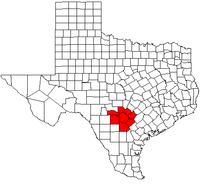
Common name: Greater San AntonioLargest city San Antonio Other cities – New Braunfels Population Ranked 25th in the U.S. - Total 2,142,508 (2010) - Density N/A/sq. mi.
N/A/km²Area N/A sq. mi.
N/A km²State(s) Texas Elevation - Highest point N/A feet (N/A m) - Lowest point N/A feet (N/A m) San Antonio–New Braunfels is an eight-county metropolitan area in the United States defined by the Office of Management and Budget (OMB). The metropolitan area is colloquially referred to as "Greater San Antonio" and is situated in South-Central Texas. The official 2010 U.S. Census results [1] showed the metropolitan area's population at 2.14 million—up from a reported 1.71 million in 2000—making it the 25th largest metropolitan area in the United States.[2]
The San Antonio–New Braunfels MSA is the third-largest metro area in the state of Texas, after Dallas–Fort Worth–Arlington and Houston–Sugar Land–Baytown. It is also the third-fastest growing large metropolitan area in the state,[specify] after Austin-Round Rock-San Marcos and Houston-Sugar Land-Baytown, respectively.
Counties
Census Area 2010 Census 2000 Census 1990 Census San Antonio–New Braunfels Metropolitan Area 2,142,508 1,711,703 1,407,745 Atascosa, Texas 44,911 38,628 30,533 Bandera, Texas 20,485 17,645 10,562 Bexar, Texas 1,714,773 1,392,931 1,185,394 Comal, Texas 108,472 78,021 51,832 Guadalupe, Texas 131,533 89,023 64,873 Kendall, Texas 33,410 23,743 14,589 Medina, Texas 46,006 39,204 27,312 Wilson, Texas 42,918 32,408 22,650 The MSA covers a total of 7,387 sq. mi. 7,340 sq. mi. is land and 47 sq. mi. is water.
Communities
Places with more than 1,000,000 people
- San Antonio (Principal city)
Places with 50,000 to 100,000 people
- New Braunfels (Principal city)
Places with 25,000 to 50,000 people
Places with 10,000 to 25,000 people
Places with 5,000 to 10,000 people
- Alamo Heights
- Bulverde
- Fair Oaks Ranch
- Floresville
- Helotes
- Hondo
- Kirby
- Lackland AFB
- Lakehills
- Pleasanton
- Selma
- Terrell Hills
- Windcrest
Places with 1,000 to 5,000 people
- Balcones Heights
- Castle Hills
- Castroville
- Charlotte
- China Grove
- Comfort
- Cross Mountain
- Devine
- Elmendorf
- Garden Ridge
- Hill Country Village
- Hollywood Park
- Jourdanton
- LaCoste
- La Vernia
- Lytle
- Marion
- McQueeney
- Medina
- Natalia
- Nixon (partial)
- Northcliff (former)
- Olmos Park
- Poteet
- Poth
- Randolph AFB
- Redwood
- Scenic Oaks
- Shavano Park
- Somerset
- St. Hedwig
- Stockdale
- Von Ormy
Places with fewer than 1,000 people
Unincorporated places
- Adkins
- Amphion
- Atascosa
- Bandera Falls
- Carpenter
- D'Hanis
- Dunlay
- Fischer
- Kicaster
- Leming
- Leon Springs
- Macdona
- Mico
- Pearson
- Pandora
- Pipe Creek
- Rio Medina
- Saspamco
- Sayers
- Spring Branch
- Sutherland Springs
- Tarpley
- Vanderpool
- Yancey
Economy
The San Antonio–New Braunfels metropolitan area is home to six Fortune 1000 companies. Valero Energy Corp, Tesoro Petroleum Corp, Clear Channel Communications, USAA, and NuStar Energy are located in San Antonio. Rush Enterprises is located in New Braunfels.
Transportation
Interstate Highways
 Interstate 10- West to El Paso, east to Houston
 Interstate 35- North to Dallas, south to Laredo
 Interstate 37- South to Corpus Christi
 Interstate 410- Loop around San Antonio, also passes through the cities of Castle Hills, Balcones Heights, and Leon Valley
Other major highways
 U.S. Highway 87- South to Victoria, north to San Angelo
 U.S. Highway 90- West to Uvalde
 U.S. Highway 181- South to Beeville
 U.S. Highway 281- North to Wichita Falls, south to McAllen
Demographics
As of the census[1] of 2000, there were 1,711,703 people, 601,265 households, and 432,131 families residing within the MSA. The racial makeup of the MSA was 71.4% White, 6.2% African American, 0.8% Native American, 1.4% Asian, 0.1% Pacific Islander, 16.6% from other races, and 3.4% from two or more races. Hispanic or Latino of any race were 50.4% of the population.
The median income for a household in the MSA was $40,764 and the median income for a family was $46,686. Males had a median income of $32,143 versus $24,007 for females. The per capita income for the MSA was $18,713.
See also
References
- ^ a b "American FactFinder". United States Census Bureau. http://factfinder.census.gov. Retrieved 2008-01-31.
- ^ "Table 1. Annual Estimates of the Population of Metropolitan and Micropolitan Statistical Areas: April 1, 2000 to July 1, 2009 (CBSA-EST2009-01)" (CSV). 2009 Population Estimates. United States Census Bureau, Population Division. 2010-03-23. http://www.census.gov/popest/metro/tables/2009/CBSA-EST2009-01.csv. Retrieved 2010-03-29.
50 largest metropolitan statistical areas in the United States by population - New York
- Los Angeles
- Chicago
- Dallas–Fort Worth
- Philadelphia
- Houston
- Washington
- Miami
- Atlanta
- Boston
- San Francisco–Oakland
- Detroit
- Riverside–San Bernardino
- Phoenix
- Seattle
- Minneapolis–St. Paul
- San Diego
- St. Louis
- Tampa–St. Petersburg
- Baltimore
- Denver
- Pittsburgh
- Portland
- Sacramento
- San Antonio
- Orlando
- Cincinnati
- Cleveland
- Kansas City
- Las Vegas
- Memphis
- Louisville
- Richmond
- Oklahoma City
- Hartford
- New Orleans
- Buffalo
- Raleigh
- Birmingham
- Salt Lake City
Categories:- San Antonio metropolitan area
- Geography of Atascosa County, Texas
- Geography of Bandera County, Texas
- Geography of Bexar County, Texas
- Geography of Comal County, Texas
- Geography of Guadalupe County, Texas
- Geography of Kendall County, Texas
- Geography of Medina County, Texas
- Geography of Wilson County, Texas

Wikimedia Foundation. 2010.