- New Jersey Route 31
-
New Jersey Route 30 redirects here. For the current highway called Route 30, see U.S. Route 30.This article is about the current New Jersey Route 31. For the former Route 31, see New Jersey Route 31 (pre-1953).
Route 31
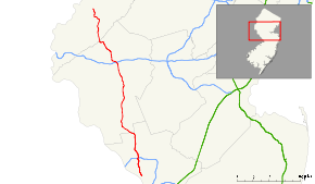
NJ 31 highlighted in redRoute information Maintained by NJDOT and Mercer County Length: 48.93 mi[1] (78.75 km) Existed: 1967 – present Major junctions South end: 


 US 1 Bus. / US 206 in Trenton
 I-95 in Hopewell Township
 US 202 in East Amwell Township
 US 202 / Route 12 in Flemington

 I-78 / US 22 in Clinton Township
 Route 57 in Washington
North end:  US 46 in White Township
Highway system New Jersey State Highway Routes
Interstate and US←  US 30
US 30Route 32  →
→←  Route 68
Route 70  →
→Route 31 is a state highway in New Jersey, United States. It runs 48.93 mi (78.75 km) from U.S. Route 206 (also signed as U.S. Route 1 Business) in Trenton, Mercer County north to an intersection with U.S. Route 46 in Buttzville in White Township, Warren County. Along the way, Route 31 heads through the communities of Flemington, Clinton and Washington. Most of the highway is state-maintained; however, the section within the city limits of Trenton is maintained by Mercer County. Much of Route 31 is a two-lane highway that passes through farmland, woodland, and mountainous areas. Two portions of the route—from Trenton to Pennington and from Ringoes to Clinton—consist of more development.
The highway was constructed from 1926 to 1935. Route 31 has carried two different numbers in the past. It was known as Route 30 between 1927 and 1953, when it was renumbered to Route 69 to avoid conflicting with U.S. Route 30 in southern New Jersey. It was renumbered to Route 31 in 1967 due to sign theft that resulted from the sexual meaning of the number 69. There were plans made in the late 1960s and early 1970s to build a freeway in the Route 31 corridor that would begin in the Trenton area and extend as far north as Interstate 84 in Port Jervis, New York; however, it was canceled in the mid-1970s due to opposition from area residents and environmental and financial constraints. In recent years, the portion of Route 31 between Flemington and Clinton has been widened to four lanes. In addition, there was a failed project to build a bypass of Flemington that would have also eliminated the Flemington Circle.
Contents
Route description
Mercer County
Route 31 heads north from U.S. Route 1 Business and U.S. Route 206 at the Trenton Battle Monument in Trenton, Mercer County on county-maintained Pennington Road, a two-lane, undivided road. The route passes by residences and some businesses in the northern part of Trenton, crossing County Route 653 (Calhoun Street). Route 31 enters Ewing Township and becomes state-mantainted at the point where it crosses County Route 634 (Parkway Avenue).[1][2] The route continues north through suburban residential areas of the township and passes to the west of The College of New Jersey campus before crossing County Route 636 (Upper Ferry Road/Ewingville Road).[1][2] It crosses into Hopewell Township and briefly becomes a four-lane divided highway as it interchanges with Interstate 95. Past this interchange, Route 31 continues north as an undivided road through a mix of residences with some businesses, meeting County Route 546 and County Route 640 at a traffic circle. It continues past the circle as a two-lane, undivided road and bypasses Pennington to the west, running through wooded residential areas. The route briefly skirts into Pennington twice, where it is a divided highway as it crosses over CSX's Trenton Subdivision. Route 31 enters Pennington again, heading through a mix of residential areas and commercial establishments, before heading back into Hopewell Township. Here, the road meets County Route 640 (North Main Street) again, and heads north into farmland and woodland with some homes.[1][2] It eventually turns to the northwest and crosses County Route 518 (Lambertville-Hopewell Road).[1]
Hunterdon County
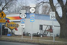
Upon crossing County Route 518, Route 31 enters East Amwell Township, Hunterdon County and continues through areas of farm fields and woods with intermittent residences and businesses. The route eventually forms the border between East Amwell Township and West Amwell Township and intersects County Route 579 (Harbourton Road). The two routes run concurrent to the northwest, becoming a three-lane road with a center left-turn lane that crosses entirely into East Amwell Township before resuming along the border of East and West Amwell Townships. The road becomes a divided highway and crosses entirely into East Amwell Township again before it comes to an interchange with U.S. Route 202, where County Route 579 continues north into Ringoes and Route 31 heads north along U.S. Route 202, a four-lane, divided highway with intersections featuring jughandle ramps.[1]
U.S. Route 202 and Route 31 head to the north, coming to an intersection with Old York Road, which heads to the southwest as Route 179 and to the northeast as County Route 514. Past this intersection, the road forms the border between East Amwell Township to the west and Raritan Township to the east before crossing entirely into Raritan Township.[3] The road continues north through farms, reaching commercial development as it approaches the Flemington area.[2] Past an intersection with County Route 611 (South Main Street), the road widens to six lanes and crosses into Flemington.[3] The road comes to the Flemington Circle where U.S. Route 202 continues to the northeast, Route 12 heads to the west, and Route 31 continues to the north on a five-lane, undivided road.[1]
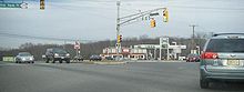
 NJ 31 heading southbound towards I-78/US 22 in Clinton
The route crosses back into Raritan Township, where it briefly becomes a four-lane divided highway before reentering Flemington. Not long afterward, it heads into Raritan Township again, where it crosses County Route 523 (Walter E. Foran Boulevard) and passes by the former site of Flemington Speedway, now a commercial development called Raritan Town Square. Route 31 passes through suburban development before turning into a four-lane, divided highway with some intersections controlled by jughandles and crossing over the South Branch Raritan River into Readington Township. It continues north through a mix of farms and wooded areas with some residential areas, crossing into Clinton Township.[1][2]
Route 31 comes to an interchange with Interstate 78 and U.S. Route 22, where it turns to the northwest into a more developed setting and interchanges with Route 173. The road runs through Clinton Town, where it crosses the South Branch Raritan River again. Back in Clinton Township, Route 31 intersects County Route 513 (Halstead Street), forming a concurrency with that route and running along the eastern shore of Spruce Run Reservoir. County Route 513 splits from Route 31 by heading north on West Main Street and Route 31 continues north, narrowing to a two-lane undivided road. The route crosses into Lebanon Township, where it heads northwest across the wooded Musconetcong Mountains. Route 31 passes through Glen Gardner, which it enters upon crossing Sprunce Run, before heading into Hampton, where it heads west through that community as a three-lane road with two southbound lanes and one northbound lane.[1][2]
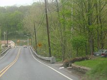 NJ 31 nearing the northern terminus at US 46 in Buttzville
Warren County
Route 31 crosses the Musconetcong River into Washington Township, Warren County, where it heads north into the agricultural Musconetcong Valley. It heads into Washington Borough, where the road becomes four lanes and crosses Route 57 (Washington Avenue). Past the Route 57 intersection, Route 31 narrows to three lanes, and becomes a two-lane road again as it crosses back into Washington Township at the Essex Road intersection.[1] It heads into farmland before turning northwest and heading across Oxford Mountain, entering Mansfield Township. While crossing Oxford Mountain, Route 31 skirts along the border between Mansfield Township and Washington Township. The route enters Oxford Township, where it heads through the community of Oxford as a four-lane road. Route 31 continues north through a mix of woods and agricultural areas past Oxford, crossing into White Township at the East Quarry Road intersection and coming to its terminus at U.S. Route 46.[1][2]
History
Old roads and construction
 A bridge in Hampton in 1998 of NJ State Highway Route 30, constructed in 1934[4]
Before the state recevied ownership of Route 31, the portion of the highway from Clinton to Oxford was part of the Spruce Run Turnpike. The turnpike was chartered by the New Jersey State Assembly on February 6, 1813 and was maintained and tolled by the Spruce Run Turnpike Company.[5] The turnpike served as a connector along the old Hopewell Road from modern-day Lambertville (then called Georgetown) to New Brunswick. The road also served as a highly-used connector route for the Jersey and Castenoga wagon lines, which served both of the aforementioned communities.[6] The route from Trenton to Pennington was part of the Pennington Turnpike, another privately maintained pre-designation highway. The turnpike was chartered on March 17, 1854 by the General Assembly along an alignment of the old Pennington Road. The turnpike road was to be constructed no further than 32 feet (9.8 m) in breadth, and to be made out of stone, plank or gravel. The turnpike cost one cent for every carriage or sled pulled by horses or mules (and one cent more for every animal), five mills for horse and rider and every dozen of pigs and sheep. It cost two cents to move a dozen cattle, mules or horses. Fines were levied as high as $10 (1854 USD) to anyone who vandalized any structure along the turnpike. If the company did not construct their highway in six years, the state would then take over and make it a public highway.[7] On November 1, 1898, the 7-mile (11 km) long turnpike, made mostly of stone, was taken over by the state at a cost of $31,661.87 (1898 USD). Repairs were slated to be completed on the road by October 31, 1899.[8] Also on March 17, 1854, the state legislature made the charter official for the Hopewell and Ewing Turnpike,[9] which used the portion of NJ 31 from Pennington to the current-day intersection with County Route 654.[10] The turnpike was taken over by the state in 1897 and the privately-maintained company was dissolved.[11]
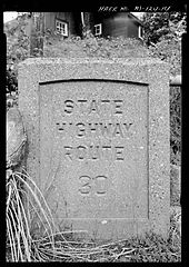
 Route 30 (1927-1953)
The formation of current-day Route 31 began around 1916, when a portion of the highway, along the community of Hampton was taken over by the state and was repaired to state standards for $300 (1916 USD).[12] In 1923, the state of New Jersey passed the Good Roads Act, which greatly expanded the state highway system in New Jersey. This act took over pre-existing highways and rebuilt them to a standard mandated by the state. Construction began on Route 31 in 1926, when the State Highway Department began work at the southern terminus in Trenton. A total of 11 bridges were constructed along the highway during this time, signifying the route's construction northward. The oldest ones, dating back to 1926, were located in Ewing Township and Oxford Township. The one in Ewing Township was along the first portion of the highway to be constructed.[13] By 1929, the construction had reached Lawrence Township, where another long stretch of highway was built.[14] During 1930, the construction had reached Clinton,[15] Glen Gardener,[16] and Washington.[17] Construction of the highway progressed northbound, with sections of the Mercer-Hunterdon-Warren route reaching Hunterdon County in 1931. The Hunterdon County portion up to the Musconetcong River was constructed for six months, with completion in October 1931. Construction of the highway northward from the Musconetcong River started in October of the same year. The mainline construction reached the northern terminus in Buttzville in 1932. The route, although the construction had reached its northern end, was not complete due to bypasses around Clinton and Pennington were proposed to be built. These bypasses were never constructed, and during 1934, more portions of the highway in Hunterdon County were finished. The route was completed in 1935, providing an uninterrupted route from the capital city of Trenton to northern Warren County.[4]
Designation
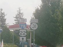
 Sign for Route 31 along former alignment (County Route 579) in Ringoes that was bypassed in 1965. A "to" banner should be included above the Route 31 marker.
What is today Route 31 was defined in the 1927 New Jersey state highway renumbering as Route 30, a highway that began in Trenton and ended in Buttzville.[18][19] In the 1953 renumbering, Route 30 was renumbered as Route 69, as the number conflicted with U.S. Route 30 in southern New Jersey.[20][21] The bypass of Ringoes, shared with U.S. Route 202, opened in the 1960s.[22] Due to the sexual meaning of the number and resulting sign theft, Route 69 was changed in 1967 to Route 31.[23]
A limited-access freeway was once planned to serve traffic along the Route 31 (then Route 69) corridor. Plans came forth in the 1960s for a highway to run along Route 69 from the in-construction U.S. Route 1 freeway (then designated Route 174[24]) to the U.S. Route 202 freeway in Ringoes. The estimated cost to build the highway according to the proposal estimated to $18 million, with construction completing in 1975.[25][26] Preparing for construction of the new highway, the New Jersey Department of Transportation acquired right-of-way in the area of Ewing Township, including portions between Ewingville Road (Mercer County Route 636) and Bull Run Road.[27]
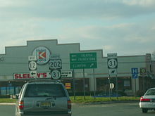 U.S. Route 202 southbound at junction with Route 12 and Route 31, known as the Flemington Circle
There were plans to extend the freeway further in both directions, including northward to Interstate 80 in Hope Township and southward to Interstate 195. Each of these two extensions were brought forth in the 1960s, and were later shelved due to lack of support. In the early 1970s, a 36-mile (58 km) long extension of Route 31 was proposed from Oxford, connecting the highway with the proposed Route 23 freeway to Interstate 84 near Port Jervis, New York. This northern freeway extension of Route 31 was to be known as Route F-31 and the Foothills Freeway, and was to run through the Kittatinny Mountains, passing through Stokes State Forest and High Point State Park. The proposal gave an estimated price tag of about $105 million (1970s USD). The northern freeway faced high opposition from residents living in Warren and Sussex counties, who feared environmental damage. A group called Opponents of the Foothills Freeway formed to prevent the road from being built. Along with the growing opposition, environmental and financial issues arose, causing the New Jersey Department of Transportation to cancel the Route 31 from being built mid-1970s.[28]
Following the completion of Interstate 287's New Jersey portion in 1993, more out-of-state tractor trailer drivers began to use the alignment of Route 31 as a toll-free alternative to the New Jersey Turnpike.[29] On July 16, 1999, oversize trucks were banned from using Route 31 as part of a larger statewide ban imposed on New Jersey roads not a part of the National Highway System by then-governor Christine Todd Whitman. The legislation had a significant effect on trucks that followed Route 31 as it forced them to use Interstate 287 and the New Jersey Turnpike instead.[30] In the mid-2000s, the portion of Route 31 was widened during extensive construction between Flemington and Clinton that widened the road to four lanes.[31][32]
The South Branch Parkway
In 2005, the New Jersey Department of Transportation introduced a case study for Route 31 for their New Jersey:Future in Transportation project. Over time, the residents and business owners of Raritan Township and Flemington had growing concerns over the congestion along the highway and U.S. Route 202. After trying to use vacant land to the east of the current alignment, the Department of Transportation put forth the Flemington Bypass, trying to relieve congestion on Route 31 along the commercial district and to provide access to the industrial land between the two highways and the South Branch River. The project was never completed and the proposed site remains undeveloped.[33] The Department of Transportation is now looking at a scaled-down bypass, proposed as the South Branch Parkway, to connect Route 31 to U.S. Route 202 in Flemington.[34]
The parkway was to be built as a two-lane alternative to Route 31 defining the border of the suburban and rural portions of Flemington Borough and Raritan Township. Along with the new parkway, a brand-new local street network was proposed to help support the new alignment. These would minimize the pressure of traffic on Route 31 and include better roads for bicycles and pedestrians. More direct routes to different portions of the community would be provided to maintain the community's character. The proposed parkway was to also help upgrade the sensitive history along the South Branch River.[33] According to the 2008 highway plans, the South Branch Parkway would cost the state more than $2.2 million (2008 USD) in funds to put together the survey of lands in the proposed alignment. Some of these funds for the survey were originally intended to go towards the removal of the Flemington Circle.[35]
Major intersections
County Location Mile[1] Destinations Notes Mercer Trenton 0.00
US 1 Bus. / US 206 (North Warren Street, North Broad Street, Martin Luther King Jr. Boulevard)Hopewell Township 4.85 I-95Exit 4 (I-95) 6.09 
 CR 546 (Washington Crossing-Pennington Road, Blackwell Road) / CR 640 north (South Main Street)
Traffic circle Hunterdon East Amwell Township 12.27  CR 518 (Lambertville-Hopewell Road)
West Amwell Township 13.97  CR 579 south (Harbourton Road)
South end of CR 579 overlap East Amwell Township 16.36 US 202 south / CR 579 north (Linvale-Harbourton Road)Interchange; north end of CR 579 overlap
south end of US 202 overlap17.53 
 Route 179 south / CR 514 east (Old York Road)
Flemington 22.02 US 202 north / Route 12 west (Samuel Hill Highway)Flemington Circle; north end of US 202 overlap Raritan Township 23.43  CR 523 (Walter E. Foran Boulevard)
Clinton Township 31.89 I-78 / US 22Exit 17 (I-78) 32.43  Route 173 (Old Highway 22)
33.41  CR 513 south (Halstead Street)
South end of CR 513 overlap 34.07 CR 513 north (West Main Street)North end of CR 513 overlap Warren Washington 42.84 Route 57 (Washington Avenue)White Township 48.93 US 461.000 mi = 1.609 km; 1.000 km = 0.621 mi See also
 U.S. Roads portal
 New Jersey portal
References
- ^ a b c d e f g h i j k l "Route 31 straight line diagram" (PDF). New Jersey Department of Transportation. http://www.state.nj.us/transportation/refdata/sldiag/00000031__-.pdf. Retrieved 2007-04-09.
- ^ a b c d e f g Google, Inc. Google Maps – overview of New Jersey Route 31 (Map). Cartography by Google, Inc. http://maps.google.com/maps?f=d&source=s_d&saddr=martin+luther+king+jr+blvd+and+pennington+avenue+trenton,+nj&daddr=route+31+%40+40.8333,+-75.0014&geocode=%3BFRQRbwIdyJGH-w&hl=en&mra=ls&sll=40.824267,-75.012846&sspn=0.030656,0.055017&ie=UTF8&t=h&z=9. Retrieved 2008-12-08.
- ^ a b "Route 202 straight line diagram" (PDF). New Jersey Department of Transportation. http://www.state.nj.us/transportation/refdata/sldiag/00000202__-.pdf. Retrieved 2008-12-08.
- ^ a b Historic American Engineering Record, ed (1998). Route 31 Bridge, New Jersey Route 31, crossing disused main line of, Hampton, Hunterdon County, NJ. National Park Service. pp. 4–7.
- ^ Votes and proceedings of the ... General Assembly of the State of New Jersey. New Jersey General Assembly. c. 1835. http://books.google.com/?id=1dUMAAAAYAAJ&pg=PA12&dq=Spruce+Run+Turnpike&q=Spruce%20Run%20Turnpike. Retrieved August 9, 2009.
- ^ Schmidt, Hubert Glasgow (1945). Rural Hunterdon. Rutgers University Press. pp. 169. ISBN 083715765X. http://books.google.com/?id=MnNkAAAAMAAJ&q=Spruce+Run+Turnpike&dq=Spruce+Run+Turnpike. Retrieved August 8, 2009.
- ^ Acts of the Legislature of the State of New Jersey. New Jersey State Legislature. 1854. http://books.google.com/?id=DEI4AAAAIAAJ&pg=PA434&dq=Pennington+Turnpike&q=Pennington%20Turnpike. Retrieved August 10, 2009.
- ^ Annual report of the Commissioner of Public Roads. New Jersey. Commissioner of Public Roads. 1898. http://books.google.com/?id=Z5vVAAAAMAAJ&pg=PA8&dq=Pennington+Turnpike&q=Pennington%20Turnpike. Retrieved August 10, 2009.
- ^ Hood, John (1905). Index of colonial and state laws of New Jersey, between the years 1663 and 1903 inclusive. Sinnickson Chew & Sons Company. pp. 1081. http://books.google.com/?id=jZgZAAAAYAAJ&pg=PA1081&dq=Hopewell+and+Ewing+Turnpike&q=. Retrieved August 10, 2009.
- ^ Moraeski, Dan (2009). "Map of NJ Turnpikes". Alps Roads. http://www.alpsroads.net/roads/nj/log/tpmap.pdf. Retrieved August 10, 2009.
- ^ Klinger, Oliver C. (1923). Obsolete securities. Oildom Publishing Company.
- ^ Annual report of the commissioner of public roads. New Jersey. Commissioner of public roads. 1916. pp. 53. http://books.google.com/?id=je0NAAAAYAAJ&pg=PA53&dq=Spruce+Run+Turnpike&q=Spruce%20Run%20Turnpike. Retrieved August 9, 2009.
- ^ National Bridge Inventory, ed (2007). Structure Number: ++++++++1118150. United States Department of Transportation. pp. 1.
- ^ National Bridge Inventory, ed (2007). Structure Number: ++++++++1119156. United States Department of Transportation. pp. 1.
- ^ National Bridge Inventory, ed (2007). Structure Number: ++++++++1013152. United States Department of Transportation. pp. 1.
- ^ National Bridge Inventory, ed (2007). Structure Number: ++++++++1013154. United States Department of Transportation. pp. 1.
- ^ National Bridge Inventory, ed (2007). Structure Number: ++++++++2110155. United States Department of Transportation. pp. 1.
- ^ State of New Jersey, Laws of 1927, Chapter 319.
- ^ Williams, Jimmy and Sharon. "1927 New Jersey Road Map". 1920s New Jersey Highways. http://www.jimmyandsharonwilliams.com/njroads/1920s/images/1927_routes.gif. Retrieved 2008-10-08.
- ^ 1953 renumbering. New Jersey Department of Highways. http://en.wikisource.org/wiki/1953_New_Jersey_state_highway_renumbering. Retrieved July 31, 2009
- ^ "New Road Signs Ready in New Jersey". The New York Times. December 16, 1952. http://img123.imageshack.us/img123/6933/19521216newroadsignsreaiu6.jpg. Retrieved 2009-07-20.
- ^ Chevron Oil Company (1969). Map of New Jersey (Map). Cartography by H.M. Gousha.
- ^ "Record $105,400 Prize Money Listed for Grand Prix Sunday". New York Times. September 27, 1967.
- ^ Milepost Log of State Highways (1969 ed.). New Jersey State Highway Department. 1969.
- ^ Transportation 1985: A Regional Plan. Tri-State Transportation Commission. 1966.
- ^ New Jersey Highway Facts. New Jersey Department of Transportation. 1967.
- ^ Anderson, Steve; Raymond C. Martin (2009). "Unbuilt NJ 31 Freeway". Eastern Roads. http://www.nycroads.com/roads/NJ-31/. Retrieved 2009-09-14.
- ^ "Interstate 80-84 Links Opposed". The New York Times. November 27, 1972.
- ^ Newman, Andy (July 23, 1995). "ROAD AND RAIL; Truckers Carve a New Route, Crowding a Two-Lane Road". The New York Times. http://query.nytimes.com/gst/fullpage.html?res=990CEFD6133AF930A15754C0A963958260. Retrieved 2008-12-11.
- ^ Futterman, Matthew (July 17, 1999). "NJ Bars Huge Rigs on Most Highways". The Star-Ledger.
- ^ "APPENDIX G-Current and Completed Hunterdon County Transportation Projects". Hunterdon County.
- ^ "Award of Merit – Highway-Route 31 Dualization". New York Construction News. http://newyork.construction.com/projects/04_BestOf/Rt31.asp. Retrieved 2008-12-11.
- ^ a b "Route 31 - Hunterdon County, New Jersey: Land Use and Transportation Plan". New Jersey Department of Transportation. 2005. http://www.state.nj.us/transportation/works/njfit/case/route31.shtm. Retrieved 2009-09-14.
- ^ Higgs, Larry (December 7, 2004). "Scaled down Rt. 31 bypass the future of Jersey roads". The Courier News. http://www.docstoc.com/docs/2600956/Scaled-down-Rt-31-bypass-the-future-of-Jersey-roads. Retrieved 2008-12-11.
- ^ "Route 31, Integrated Land Use & Transportation Plan". New Jersey Department of Transportation. 2008. http://www.state.nj.us/transportation/capital/stip0811/sec3/routes/rt31.pdf. Retrieved 2009-09-14.
External links
Categories:- State highways in New Jersey
- Transportation in Hunterdon County, New Jersey
- Transportation in Mercer County, New Jersey
- Transportation in Warren County, New Jersey


Wikimedia Foundation. 2010.