- Maryland Route 405
-
Maryland Route 405
Price Station Road 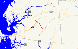
Route information Maintained by MDSHA Length: 8.59 mi[1] (13.82 km) Major junctions South end:  MD 304 near Bridgetown
 US 301 in Price
North end:  MD 19 near Church Hill
Location Counties: Queen Anne's Highway system Maryland highway system
Interstate • US • State • Minor • Former • Turnpikes←  MD 404
MD 406  →
→Maryland Route 405 (MD 405) is a state highway in the U.S. state of Maryland. Known as Price Station Road, the state highway runs 8.59 miles (13.82 km) from MD 304 near Bridgetown north to MD 19 near Church Hill. MD 405 connects Church Hill and Bridgetown with the central Queen Anne's County community of Price, where the highway intersects U.S. Route 301 (US 301). The state highway was constructed from Price to south of Roe in the early 1930s and from Price to Church Hill in the mid 1930s. MD 405 was extended from Roe to Bridgetown in Caroline County in the early 1940s. The Bridgetown end was truncated when MD 304 was extended east to Bridgetown in the mid 1960s.
Contents
Route description
MD 405 begins at an intersection with MD 304 (Ruthsburg Road) west of Bridgetown. The state highway heads northwest through farmland as two-lane Prince Station Road, passing Shawn Road before intersecting Hope Road and Roe Ingleside Road in the hamlet of Roe. After crossing German Branch and passing Roseville Memorial Cemetery, MD 405 reaches the hamlet of Price, where it crosses the Centreville Branch of the Northern Line of the Maryland and Delaware Railroad at grade. Immediately beyond the railroad track, the state highway intersects the dual carriageways of US 301 (Blue Star Memorial Highway), which are separated by a wide median. MD 405 curves north at Flat Iron Square Road and bridges Southeast Branch before reaching its northern terminus at MD 19 (Roberts Station Road) south of Church Hill.[1][2]
History
The first section of MD 405 was paved from the railroad track south a short distance through Price by 1930.[3] That highway was extended in two sections that were started in 1930: the highway between Roe and Shawn Road south of Roe was completed in 1932, while the segment between Roe and the existing road at Price was completed in 1933.[4][5][6] MD 405 from MD 19 south to Flat Iron Square Road was also completed in 1933.[5][6] The gap between Price and Church Hill was filled in 1935.[7][8] The highway from Shawn Road south and then east along present day MD 304 to Bridgetown was constructed between 1940 and 1942.[9][10][11] MD 405's southern terminus was moved to its present location when MD 304 was extended east from Ruthsburg to Bridgetown in 1964.[12]
Junction list
The entire route is in Queen Anne's County.
Location Mile
[1]Intersection Notes Bridgetown 0.00 MD 304 (Ruthsburg Road) – Bridgetown, CentrevilleSouthern terminus Price 5.98 US 301 north (Blue Star Memorial Highway) – Wilmington6.08 US 301 south (Blue Star Memorial Highway) – Bay BridgeChurch Hill 8.59 MD 19 (Roberts Station Road) – Ingleside, Church HillNorthern terminus 1.000 mi = 1.609 km; 1.000 km = 0.621 mi References
- ^ a b c "Highway Location Reference: Queen Anne's County" (PDF). Maryland State Highway Administration. 2009. http://www.marylandroads.com/Location/2009_QUEENANNES.pdf. Retrieved 2010-09-29.
- ^ Google, Inc. Google Maps – Maryland Route 409 (Map). Cartography by Google, Inc. http://maps.google.com/maps?f=d&source=s_d&saddr=MD-405+N%2FPrice+Station+Rd&daddr=MD-405+N%2FPrice+Station+Rd&geocode=FR6MUwIdnN95-w%3BFWYVVQId6LJ4-w&hl=en&mra=ls&sll=39.104755,-75.955181&sspn=0.061143,0.154324&ie=UTF8&t=h&z=12. Retrieved 2010-09-29.
- ^ Maryland Geological Survey. Map of Maryland Showing State Road System: State Aid Roads and Improved County Road Connections (Map) (1930 ed.).
- ^ Report of the State Roads Commission of Maryland. 1927-1930. Baltimore: Maryland State Roads Commission. 1930-10-01. p. 225. http://www.archive.org/details/reportofstateroa1927mary. Retrieved 2010-09-29.
- ^ a b Maryland Geological Survey. Map of Maryland Showing State Road System: State Aid Roads and Improved County Road Connections (Map) (1933 ed.).
- ^ a b Report of the State Roads Commission of Maryland. 1931-1934. Baltimore: Maryland State Roads Commission. 1934-12-28. pp. 350–351. http://www.archive.org/details/reportofstateroa1931mary. Retrieved 2010-09-29.
- ^ Maryland Geological Survey. Map of Maryland Showing State Road System: State Aid Roads and Improved County Road Connections (Map) (1935 ed.).
- ^ Report of the State Roads Commission of Maryland. 1935-1936. Baltimore: Maryland State Roads Commission. 1936-12-04. p. 67. http://www.archive.org/details/reportofstateroa1935mary. Retrieved 2010-09-29.
- ^ Report of the State Roads Commission of Maryland. 1939-1940. Baltimore: Maryland State Roads Commission. 1941-03-15. p. 91. http://www.archive.org/details/reportofstateroa1939mary. Retrieved 2010-04-05.
- ^ Report of the State Roads Commission of Maryland. 1941-1942. Baltimore: Maryland State Roads Commission. 1943-03-15. p. 81. http://www.archive.org/details/reportofstateroa1941mary. Retrieved 2010-09-28.
- ^ Maryland State Roads Commission. Maryland: Official Highway Map (Map) (1946-47 ed.).
- ^ Maryland State Roads Commission. Maryland: Official Highway Map (Map) (1964 ed.).
External links
Roads in Queen Anne's County, Maryland State highways 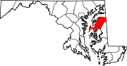
U.S. Highways Categories:- State highways in Maryland
- Roads in Queen Anne's County, Maryland


Wikimedia Foundation. 2010.