- Texas State Highway Loop 20
Infobox TX State Highway
250px
type=Loop
route=20
alternate_name=Bob Bullock Loop
length_mi=16.6
formed=1939
dir1=CW
dir2=CCW
from=World Trade International Bridge
junction=
|to=
previous_type=Loop
previous_route=19
next_type=Loop
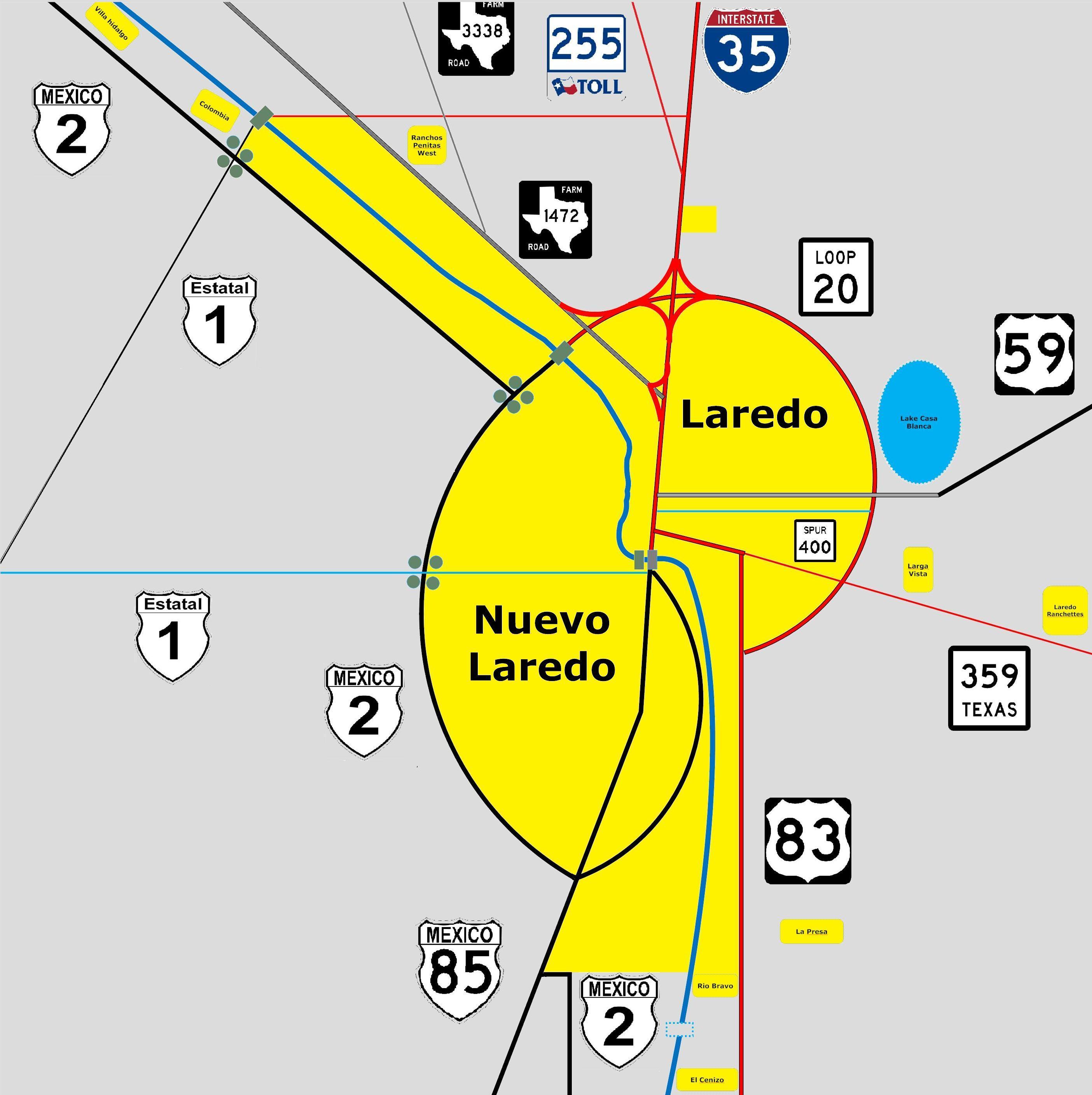
next_route=21Loop 20, [TxDOT|SL|20] also known as the
Bob Bullock Loop, is a highway loop that encircles the city ofLaredo, Texas . Loop 20 runs from theWorld Trade International Bridge at its northern point to U.S. Highway 83 at its southern point. Loop 20 is a six-lane divided highway.In recent years, much of Laredo's growth has been along Loop 20, with the construction of a new passenger terminal at
Laredo International Airport , theLaredo Entertainment Center , the new campus ofTexas A&M International University , and [http://www.doctorshosplaredo.com/ Doctors Hospital] being the most prominent projects.The
Texas Department of Transportation 's Laredo District is preparing for future growth with plans to upgrade Loop 20 into afreeway by building overpasses at major intersections and constructing frontage roads. [ [http://www.txdot.state.tx.us/local_information/laredo_district/loop_20_mobility_study/default.htm TxDOT Laredo District Loop 20 Mobility Project] ] A short freeway section currently exists from the World Trade International Bridge east to the Milo Interchange at Interstate 35, and TxDOT recently constructed adiamond interchange at Loop 20's intersection with U.S. Highway 59 in eastern Laredo [ [http://www.txdot.gov/news/local_news/laredo_news/121-2007.htm News Release: Loop 20-US 59 traffic switches - Loop 20 traffic over bridge] ] and is currently constructing a stacked interchange at Loop 20 interchange with Interstate 35.As of 2008 , TxDOT plans to complete interchanges and overpasses at all of Loop 20's major intersections within the next ten years. [Ashley Richards, [http://www.lmtonline.com/site/news.cfm?newsid=19767382&BRD=2290&PAG=461&dept_id=569392&rfi=6 "Corridor options narrow,"] "Laredo Morning Times",June 12 ,2008 .]Previous Routes
The northwest section of Loop 20 west of I-35 to
Farm to Market Road 1472 was originally part of Urban Road 3464 or Farm to Market Road 3464, [TxDOT|UR|3464] a convert|1.15|mi|km|sigfig=2|adj=on road built in 1995 to connect I-35 to FM 1472 in northernLaredo, Texas . OnDecember 19 ,2000 it was redesignated as part of Loop 20.Future Extension
Laredo has proposed extending Loop 20 south by approximately convert|10|mi|km|0 from a future interchange at SH 359 along the planned Cuatro Vientos Road, to provide an eastern bypass for south Laredo and improved access to the proposed
Laredo International Bridge 5 ; the existing route from US 83 to SH 359 would be redesignated as state highway Spur 260. [Julian Aguilar, [http://airwolf.lmtonline.com/news/archive/101107/pagea3.pdf Cuatro Vientos Back on Track] , "Laredo Morning Times",October 11 ,2007 .] [ [http://www.cityoflaredo.com/city-council/council-activities/council-minutes/2008Min/M2008-R-08.doc Minutes, Laredo City Council meeting] ,April 21 ,2008 .] [ [http://www.txdot.state.tx.us/publications/commission/2008_meetings/may29_agenda.pdf TTC minutes] ]References
Wikimedia Foundation. 2010.