- Croydon Airport
-
Croydon Airport 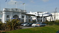
IATA: none – ICAO: EGCR Summary Airport type Public Serves London, UK Location Croydon Coordinates 51°21′23″N 000°07′02″W / 51.35639°N 0.11722°WCoordinates: 51°21′23″N 000°07′02″W / 51.35639°N 0.11722°W Website Map Location in Greater London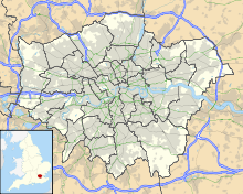
 EGCR
EGCRRunways Direction Length Surface ft m NW/SE 3,900 1,200 E/W 3,600 1,100 NE/SW 3,300 1,000 Runway Details: Airfields & Aviation Memorials by Richard Flagg Croydon Airport (ICAO: EGCR) was an airport in South London which straddled the boundary between what are now the London boroughs of Croydon and Sutton. It was the main airport for London before it was replaced by Northolt Aerodrome, London Heathrow Airport and London Gatwick Airport. The terminal building and entrance lodge are Grade II listed buildings.[1][2]
Contents
History
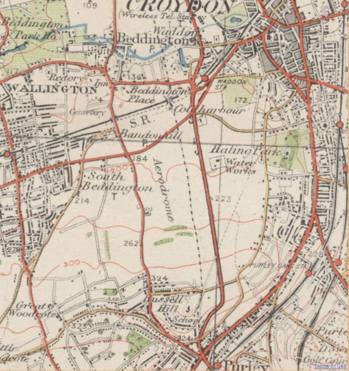
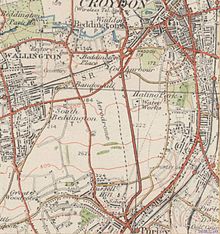 Area around Croydon Airport as it was in the 1920s or 1930s
- About May 1915: Beddington Aerodrome opened, one of a number of small airfields around London, which had been created for protection against the Zeppelin raids in World War I
- 1918: Waddon Aerodrome opened, a test-flight aerodrome adjoining National Aircraft Factory No 1.
- These two airfields were one on each side of Plough Lane (the lane running north from Russell Hill near Purley, in the accompanying old map).
- End of World War I: These two airfields were combined into London's official airport as Croydon Aerodrome as the gateway for all international flights to and from the capital. Plough Lane remained a public road across it, and road traffic on it was halted when necessary, at first by a man with a red flag, and later by a gate.[3]
- 29 March 1920: Croydon Aerodrome opened.[4] Penshurst Airfield was an alternative destination for airliners when Croydon was closed due to fog. One such diversion was on 24 September 1921, when a de Havilland DH.18 aircraft diverted to Penshurst.[5] This situation lasted until Penshurst closed on 28 July 1936.[6] It stimulated a growth in regular scheduled flights carrying passengers, mail and freight, the first destinations being Paris,[4] Amsterdam and Rotterdam. Two flights daily from Paris were scheduled for ease of communication with London during the Paris Peace Conference
- 1921: Croydon was the first airport in the world to introduce air traffic control.
- 1923: Tempelhof International Airport (Berlin) flights were added. It was the operating base for Imperial Airways, remembered in the road name Imperial Way on the site today.
- December 1924: 1924 Imperial Airways de Havilland DH.34 crash. In the subsequent public inquiry into the accident conditions at Croydon were criticized.[7]
- 1920s: Resulting expansion. In this expansion Plough Lane was closed permanently to let heavier airliners land and depart safely. A new complex of buildings was built adjoining Purley Way, including the first purpose-designed air terminal in the UK, the Aerodrome Hotel and extensive hangars, at a cost of £267,000 (£11.9 million in today's prices).[8]
- 20 January 1928: First day of operation using the new buildings and layout.
- 2 May 1928: Official opening of the new buildings and layout.
- Morning of 11 July 1936: Major Hugh Pollard, and fellow Special Operations Executive officer Cecil Bebb left Croydon Airport for the Canary Islands in a de Havilland Dragon Rapide aircraft, where they picked up General Francisco Franco, taking him to Spanish Morocco and thereby helping to trigger the outbreak of the Spanish Civil War.[9]
- The major aircraft used by Imperial Airways were the Handley Page HP42/HP45 four-engined biplanes. The first monoplane airliners used by Imperial Airways were the Armstrong Whitworth Atlantas, intended for use on the African routes.
- March 1937: British Airways Ltd operated from Croydon.
- May 1938: British Airways Ltd moved to Heston Aerodrome.
- 1938: Larger four-engined monoplanes, Armstrong Whitworth Ensign series (G-ADSR) came into service.
- September 1938: Correction of popular error: Prime Minister Neville Chamberlain, flew from Heston Aerodrome and returned there (not Croydon), with his famous "piece of paper" at the time of the Munich crisis. He made his "Peace for our time" speech not at either aerodrome, but a short while later on his return to Downing Street.[10]
- November 1938: The Chamberlain government decided that Imperial Airways, which served Empire routes, should be merged with British Airways Ltd, which served European routes. The new company was known as British Overseas Airways Corporation (BOAC).
- September 1939: World War II was declared. Croydon Airport was closed to civil aviation. It played a vital role as a fighter station during the Battle of Britain and was attacked in the first major raid over the London area. Factories in its immediate vicinity were almost destroyed with the loss of six airmen and over 60 civilians.
- 1944: Croydon became the base of RAF Transport Command, and in due course civil aircraft operations began again.
Postwar developments and final closure
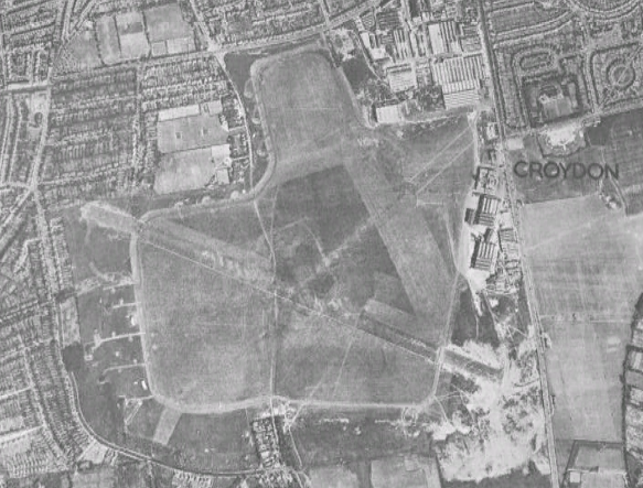
 Aerial photograph of Croydon Airport in 1945
- After 1945: It was realized that with technical advances, post-war airliners would be larger and use of airports serving capital cities would intensify. Urban spread of south London, and surrounding villages growing into towns, had by now enclosed Croydon Airport and left it with no room for further expansion, and it would soon be too small to meet evident travel demands. Heathrow was therefore designated as London's airport.
- February 1946: The airport returned to civilian control.
- 11 April 1946: A diagram in this day's issue of Flight shows 1250 yards ground run in the 170-350 direction, 1150 yards 060-240 and 1100 yards 120-300. (The numbers are degrees clockwise rotation from north.)
- 1952: It was decided to close Croydon Airport.
- Blackbushe Airport in Hampshire and Northolt Aerodrome in Middlesex also served airlines operating European scheduled flights during the 1950s.
- 30 September 1959 at 6.15pm: Croydon's last scheduled flight departed.[4] The last aeroplane to leave the aerodrome was a private flight which took off at 7.45pm on that date.[4] The airfield officially closed at 10.30pm that evening.[11]
- Sunday 27 September 2009: To mark the 50th anniversary of the closing of the airport, an 11-plane flypast (including 8 biplanes) took place (although it had initially been announced that there would be 12 aeroplanes flying).[4] The aeroplanes involved were from the Tiger Club (and other locations) and were 5 Stampe biplanes, 3 de Havilland Tiger Moth biplanes, a Jodel S150, and two Druine D.31 Turbulent aircraft.[11][12] A gold laurel leaf tribute was laid in the control tower to mark the anniversary.[11]
The area now
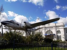 The De Havilland Heron outside Airport House
Much of the site has been built over, but some of the terminal buildings near Purley Way (the A23) are still visible, clearly identifiable as to their former purpose. The former terminal building is called Airport House,[11] and the former control tower houses a visitor's centre.[11]
A De Havilland Heron (a small propeller-driven British airliner of the 1950s), is displayed outside Airport House on struts flanking the entry path (as of November 2009). The Heron is painted as G-AOXL of Morton Air Services, which was the aircraft that flew the last passenger flight from Croydon on 30 September 1959. A Tiger Moth in RAF training scheme livery is suspended within the preserved booking hall, which functions as a dining room when required. A memorial to those lost in the Battle of Britain stands slightly to the south.
Although Croydon has long ceased operation, the two cut ends of Plough Lane have never been reunited, but the area between has been developed instead into parkland, playing fields, and the Roundshaw residential estate with its roads aptly named after aviators and aircraft. All that remains of the runways is a small area of tarmac (in Roundshaw Park just west of Purley Way), which can be viewed using Google Maps,[13] and the area is used primarily by walkers, model aircraft enthusiasts, and locals playing football. The church on the Roundshaw estate has a cross on its outside wall that was made from the cut down propeller of a Spitfire based at Croydon during World War II.
The area is still known as Croydon Airport for transport purposes and was the location for Croydon Water Palace.
In recognition of the historical significance of the aerodrome, two local schools (Waddon Infants School and Duppas Junior School) have merged and became The Aerodrome School from September 2010.[14][15]
In at least one recently-made movie, fictional events set at Croydon Airport were filmed near Manchester at Barton Airport, whose distinctive control tower will show.
The buildings
The Aerodrome Hotel and the terminal building including its grand booking hall were built in the neo-classical geometrical design typical of the early 20th Century. A further item that would have caught the eye of visitor and traveller alike was the time zone tower (now sadly lost) in the booking hall with its dials depicting the times in different parts of the world. Croydon Airport's Aerodrome Hotel is part of Croydon Vision 2020 regeneration plan.
The Airport Hotel survives as the Forte Posthouse.[16]
Aviators, pioneers and aircraft
The aerodrome was known the world over, its fame being spread by the many aviators and pioneers who touched down at Croydon, such as:
- Alan Cobham, who flew from Croydon to Cape Town and back in 1925-6;
- Charles Lindbergh, who flew into Croydon in 1927 shortly after completing the first solo trans-Atlantic flight;
- Bert Hinkler, who made the first flight from Croydon to Darwin, Australia in 1928;
- Charles Kingsford Smith, who beat Hinkler's record;
- Amy Johnson, the first woman to fly from Croydon to Australia, later to return to Croydon to a jubilant welcome.
- Winston Churchill, who took extensive flying lessons at Croydon and was nearly killed during a crash at take-off in 1919.[17]
- Tom Campbell Black, who with C. W. A. Scott won the MacRobertson London to Melbourne Air Race [1] in 1934;
- Juan de la Cierva, the Spanish inventor of the autogyro, who died in an aviation accident on 9 December 1936.
Accidents and incidents
- On 15 March 1923, Farman F.60 Goliath F-AEIE of Compagnie des Messageries Aériennes overran the runway on landing and collided with a building. The aircraft was later repaired and returned to service.[18]
- On 22 January 1924, Goliath F-GEAO of Air Union was destroyed by fire following an accident when landing.[18]
- On 24 December 1924 (1924 Imperial Airways de Havilland DH.34 crash), Imperial Airways de Havilland DH.34 G-EBBX crashed and caught fire shortly after take-off from Croydon, killing the pilot and all seven passengers.[19]
- On 19 May 1934, a Wibault 280 of Air France crash-landed on a cricket pitch adjacent to Croydon Airport due to running out of fuel. Only one of the ten people on board was injured.[20]
- On 31 May 1934 an Air France aircraft carrying newspapers to Paris crashed after hitting the mast of an aircraft radio navigation beacon that had been erected off the end of the white-line takeoff path, killing the two crew.
- On 9 December 1936 (1936 KLM Croydon accident), A KLM Douglas DC-2 crashed on take off at Croydon Airport on a flight to Amsterdam. The accident killed 15 out of 17 on the DC-2[21]
- On 25 January 1947 (1947 Croydon Dakota accident), a Spencer Airways Douglas Dakota failed to get airborne on a flight to Rhodesia. The aircraft struck another parked and empty aircraft, killing 11 passengers and the pilot.[22]
References
- ^ "Listed Buildings Online: Airport House". English Heritage. http://www.heritagegateway.org.uk/Gateway/Results_Single.aspx?uid=201233&resourceID=5. Retrieved 2010-05-30.
- ^ "Listed Buildings Online: Former Lodge To Croydon Airport Terminal". English Heritage. http://www.heritagegateway.org.uk/Gateway/Results_Single.aspx?uid=201234&resourceID=5. Retrieved 2010-05-30.
- ^ http://www.croydononline.org/history/places/airports.asp
- ^ a b c d e Millard, Neil (3 September 2009). "Fly past to mark 50th anniversary of Croydon Airport". The Croydon Post (online and in print) (Northcliffe Media). http://www.thisiscroydontoday.co.uk/news/Fly-past-mark-50th-anniversary-Croydon-Airport/article-1308837-detail/article.html. Retrieved 2009-09-14.
- ^ "London Terminal Aerodrome". Flight (29 September 1921): p649. http://www.flightglobal.com/pdfarchive/view/1921/1921%20-%200649.html.
- ^ "Penshurst Closed". Flight (30 July 1936): p141. http://www.flightglobal.com/pdfarchive/view/1936/1936%20-%202116.html?search=penshurst.
- ^ "Croydon Air Accident. Court of Enquiry's Report" The Times (London). Wednesday, 11 February 1925. Issue 43883, col A, B, C, D, p. 17.
- ^ UK CPI inflation numbers based on data available from Lawrence H. Officer (2010) "What Were the UK Earnings and Prices Then?" MeasuringWorth.
- ^ Article on Bebb and Pollard's flight at randompottins.blogspot
- ^ The Great Days, Croydon Airport 1928-1939, Cluett, Nash, Learmonth, p190
- ^ a b c d e Austen, Ian (7 October 2009). "Airport milestone marked by flypast". The Croydon Post (Croydon, UK: Northcliffe Media).
- ^ "Croydon Anniversary Flypast, 27 September". Professional Pilots Rumour Network. 27 September 2009. pp. 5. http://www.pprune.org/aviation-history-nostalgia/387604-croydon-anniversary-flypast-27-september.html. Retrieved 2009-09-29.
- ^ Google Maps
- ^ Charlton, Jo (7 August 2009). "Work begins on new primary school in Waddon". The Croydon Advertiser (Croydon, UK: Northcliffe Media). http://www.thisiscroydontoday.co.uk/news/Work-begins-new-primary-school-Waddon/article-1234258-detail/article.html. Retrieved 2009-10-08.
- ^ "Schools amalgamation means lift off for Aerodrome School". London Borough of Croydon. 6 August 2009. http://www.croydon.gov.uk/democracy/councilnews/874261. Retrieved 2009-10-08.
- ^ http://www.croydononline.org/history/places/airports.asp
- ^ Gilbert, Martin; Churchill, Randolph (1975). Winston S. Churchill - Volume IV 1917-1922. London: Heinemann. pp. 208.
- ^ a b "FRENCH PRE-WAR REGISTER Version 120211". Air Britain. http://www.ab-ix.co.uk/f-aaaa.pdf. Retrieved 8 March 2011.
- ^ "Air Disaster at Croydon". Flight (1 January 1925): p4. http://www.flightglobal.com/pdfarchive/view/1925/1925%20-%200004.html.
- ^ "Mishap to French Air Liner" The Times (London). Monday, 21 May 1934. Issue 46759, col F, p. 7.
- ^ http://www.reachinformation.com/define/1936_KLM_Croydon_accident.aspx
- ^ Accident description at the Aviation Safety Network
- Bob Learmonth, Joanna Nash,Douglas Cluett (ed)(1977). "The First Croydon Airport 1915-1928)", London Borough of Sutton Libraries and Arts Services. ISBN 0-9503224-3-1
- Douglas Cluett, Joanna Nash, Bob Learmonth (1980). "Croydon Airport 1928 - 1939, The Great Days", London Borough of Sutton Libraries and Arts Services, first published 1980. ISBN 0-9503224-8-2
- Charles C. Dickson.(1983) "Croydon Airport Remembered", London Borough of Sutton Libraries and Arts Services. ISBN 0-907335-12-8
- Douglas Cluett, Joanna Bogle (Nash), Bob Learmonth (1984). Croydon Airport and The Battle for Britain, London Borough of Sutton Libraries and Arts Services. ISBN 0-907335-11-X
External links
- Old Ordnance Survey map of the area as in the 1920s: see the word "Aerodrome" between the two roads going north-northwest from Purley; the westerly of those two roads is Plough Lane.
- Croydon Airport web site from Croydon Airport Society
- History of Croydon Airport web page from Croydon Online
- Various photos from Control Towers website
- Chart of Croydon Airport from The Air Pilot, published by Air Ministry, London, 1934.
- Croydon Control Tower
- Flypast over Croydon Airport - Sunday 27th September 2009 on YouTube
- Demotix - Croydon Airport 50th Anniversary Flypast photos
Buildings and structures in Croydon Highrises 100 George Street · Altitude 25 · Apollo House (Croydon) · Central One · Cherry Orchard Road Towers · Croydon Tower · Croydon transmitting station · Croydon Vocational Tower · Direct Line House · IYLO · Lunar House · Nestlé Tower · No.1 Croydon · Prudential House · Ruskin Square · Saffron Square · Taberner House · Wettern House
Notable lowrises Addington Palace · Airport House · Ashcroft Theatre · Bridge House · BRIT School · Croydon College · Croydon Clocktower (David Lean Cinema • Museum of Croydon • Croydon Central Library) · Cane Hill · Old Palace · Croydon Minster · Fairfield Halls · Grants · John Ruskin College · Croydon University Hospital · RAF Kenley · Ruskin House · Safari Cinema · The Exchange · Trinity School of John Whitgift · Warehouse Theatre
Major railway stations Major complexes Sports venues Croydon Arena · Croydon Sports Arena · Croydon Water Palace · Selhurst Park
Architecture of Croydon · Croydon Vision 2020 · List of tallest buildings and structures in Croydon
Categories:- Airports in the London region
- Art Deco buildings in London
- Croydon 2020
- Former buildings and structures of Croydon
- Grade II listed buildings in London
- Royal Flying Corps airfields
- Transport in Croydon
- Defunct airports in England


Wikimedia Foundation. 2010.