- Farallon Islands
-
Farallon National Wildlife Refuge IUCN Category IV (Habitat/Species Management Area)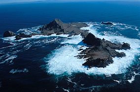
Southeast Farallon Islands from the west, with Maintop Island in the foreground (right)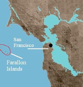
Location Pacific Ocean Nearest city San Francisco, California, USA Coordinates 37°43′30″N 123°01′49″W / 37.7249303°N 123.0302779°WCoordinates: 37°43′30″N 123°01′49″W / 37.7249303°N 123.0302779°W Area 1,036 acres (419 ha) Established 1969 Governing body United States Fish and Wildlife Service Farallone IslandsArea: 211 acres (85.4 ha) Built: 1539 NRHP Reference#: 77000332 [1] Added to NRHP: March 08, 1977  Farallon Islands, with border of Farallon Islands National Wildlife Refuge
 Southeast Farallon Islands (from nautical chart of 1957)
The Farallon Islands, or Farallones (from the Spanish farallón meaning "pillar" or "sea cliff"), are a group of islands and sea stacks in the Gulf of the Farallones, off the coast of San Francisco, California, USA. They lie 27 miles (43 km) outside the Golden Gate and 20 miles (32 km) south of Point Reyes, and are visible from the mainland on clear days. The islands are officially part of the City and County of San Francisco, California. The only inhabited portion of the islands is on Southeast Farallon Islands (SEFI), where research residents (PRBO) stay.[2]
The Farallon National Wildlife Refuge is one of 66 National Wildlife Refuges that have congressionally designated wilderness status.[3] In 1974 the Farallon Wilderness was established (Public Law 93-550) and includes all islands except the Southeast Island for a total of 141 acres (57 ha).[4]
Contents
History
 A view of the Farallon Islands
The islands were long known to the American Indians who lived in the Bay Area prior to the arrival of Europeans, but they are not thought to have traveled to them[citation needed]. The first European to record the islands was the English privateer Sir Francis Drake, who landed on the islands on 24 July 1579, in order to collect seal meat and bird eggs for his ship. He named them the Islands of Saint James, a name that survives only in one of the rocky islets of the North Farallones. The islands were given the name "Farallones" (literally, "rocks out of the sea") by Spanish explorer Sebastián Vizcaíno, who first charted them in 1603.
In the years following their discovery, during the Maritime Fur Trade era, the islands were exploited by seal hunters, first from New England and later from Russia. The Russians maintained a sealing station in the Farallones from 1812 to 1840, taking 1,200 to 1,500 fur seals annually, though American ships had already exploited the islands.[5] The first American ships Albatross, captained by Nathan Winship, and the O'Cain, captained by his brother Jonathan Winship, were sent from Boston in 1809 to establish a settlement on the Columbia River. In 1810, they met up with two other American ships at the Farallon Islands, the Mercury and the Isabella, and at least 30,000 seal skins were taken.[6][7] By 1818 the seals diminished rapidly until only about 500 could be taken annually and within the next few years, the fur seal was extirpated from the islands. It is not known whether the Northern Fur Seal or the Guadalupe Fur Seal were the islands' native fur seal, although the Northern Fur Seal is the species that began to recolonize the islands in 1996.[8]
On July 17, 1827, French sea captain, Auguste Duhaut-Cilly, sailed by the southernmost Farallon Island and counted the "crude dwellings of about a hundred Kodiaks stationed there by the Russians of Bodega...the Kodiaks, in their light boats, slip into San Francisco Bay by night, moving along the coast opposite the fort, and once inside this great basin they station themselves temporarily on some of the inner islands, from where they catch the sea otter without hindrance."[9]
After Alta California was ceded by Mexico to the US in 1848, the islands' environment became linked to the growth of the city of San Francisco. Beginning in 1853, a lighthouse was constructed on SEFI. As the city grew, the seabird colonies came under severe threat as eggs were collected in the millions for the markets of San Francisco. The trade, which in its heyday could yield 500,000 eggs a month, was the source of conflict between the egg collecting companies and the lighthouse keepers. This conflict turned violent in a confrontation between rival companies in 1863. The clash between two rival companies, known as the Egg War, left two men dead and marked the end of private companies on the islands, although the lighthouse keepers continued egging. This activity, combined with the threat of oil spills from shipping in San Francisco's shipping lanes, prompted President Theodore Roosevelt to sign Executive Order No. 1043 in 1909, creating the Farallon Reservation, protecting the northern islands of the chain. This was expanded to all the islands in 1969 when it became a National Wildlife Refuge.
The islands are the site of many shipwrecks, including the liberty ship SS Henry Bergh, a converted troop carrier that hit West End in 1944, pieces of which can still be seen from the island today (all hands were saved). The United States Coast Guard maintained a manned lighthouse until 1972, when it was automated. The islands are currently managed by the United States Fish and Wildlife Service, in conjunction with the Marin-based PRBO Conservation Science (formerly Point Reyes Bird Observatory - PRBO). The islands are currently the subject of long term ecological research. Today, the Farallones are closed to the public, although birders and wildlife enthusiasts can approach them on whale watching boats and the sail-training vessel Seaward out of Sausalito.[10]
For about eleven years, from 1902 to 1913, the former U.S. Weather Bureau maintained a weather station on the southeast island, which was connected by cable with the mainland. The results of the meteorology study were later published in a book on the California climate. Temperatures during those years never exceeded 90 °F (32 °C) or dropped to 32 °F (0 °C).[11] Years later, the National Weather Service provided some weather observations from the lighthouse on its local radio station.
Geology
The Farallon Islands are outcroppings of the Salinian Block, a vast geologic province of granitic continental crust sharing its origins with the core of the Sierra Nevada Mountains. The block was torn off far to the south of its present position and rifted north by the movement of the Pacific Plate on which the islands rest. Other nearby examples of the Salinian Block include the Point Reyes Peninsula and Bodega Head. The San Andreas Fault, marking a boundary zone between the Pacific and North American Plates, passes a few miles east of the islands.
The historic Farallon Plate is named after the islands.
Geography
 View of research station at Marine Terrace, with Farallon Island Light above
Overview
The islands string northwestward from Southeast Farallon Island for 5 miles (8.0 km). Their total land area is 0.16 square miles (0.41 km2). The islands were initially exploited for bird eggs and fur seal skins, then used as a lighthouse station and a radio station. They have been protected in the Farallon National Wildlife Refuge, first established in 1909 with the Southeast Farallons added in 1969,[12] and contain the largest seabird colony in the U.S. outside of Alaska and Hawaii. The islands are part of the City and County of San Francisco, and are considered part of Supervisorial District One (Northwest), also called Richmond District.
Block
Nr.1Island(s) or Bank Area
(m²)height
(m)Coordinates 2000 South Farallon Islands 387,688 109 37°41′49″N 123°00′07″W / 37.69694°N 123.00194°W 2001 Middle Farallon Island 3,362 6 37°43′37″N 123°01′52″W / 37.72694°N 123.03111°W 2002 North Farallon Islands 28,270 47 37°45′37″N 123°05′49″W / 37.76028°N 123.09694°W - Fanny Shoal - -4 37°46′40″N 123°10′19″W / 37.77778°N 123.17194°W 2999 2 Farallon Islands 419,320 109 1 of Block group 2, Census tract 604, San Francisco County, California [1] 2 Block Number of Territorial Waters, with an area of 247,530,823 m²
South Farallon Islands
 Aulon Island, Great Arch Rock and Sugarloaf, as seen from SEFI.
 Farallon Islands and banks further northwest
- Southeast Farallon Island (SEFI) is the largest island, with an area of 0.11985 square miles (0.3104 km2), and is the only inhabited one. The island is pyramidal in shape and 357 feet (109 m) high. The peak, Tower Hill (actually a double peak consisting of Lighthouse Hill and Little Lighthouse Hill), is the location of a lighthouse, the Farallon Island Light. The large flat area in the southeast of the island is called Marine Terrace. Immediately south of it is Mussel Flat, about 100 feet (30 m) by 400 feet (120 m), which is cut off from the main island only during high tide.
- Seal Rock (Saddle Rock), about 800 feet (240 m) south of SEFI, is about 350 feet (110 m) by 800 feet (240 m) in size and 80 feet (24 m) high.
- Maintop Island (West End) is immediately to the west of SEFI, separated by a narrow impassable gorge, The Jordan (Jordan Channel), which connects Mirounga Bay in the south to Maintop Bay in the north. It is the second largest island, and 220 feet (67 m) high at Main Top hill in its eastern part. The Great West Arch, a rock formation, is in the west of the island, and Indian Head in the south.
- The Drunk Uncle Islets are a group of small rocks just northwest off Maintop Island.
- Aulone Island and smaller Great Arch Rock (Arch Rock) are immediately north of the northern tip of SEFI, and together about 200 feet (61 m) by 350 feet (110 m) in size. They are barely separated by a narrow gorge. Great Arch Rock is not to be confused with Great West Arch, a rock formation in the west of Maintop Island.
- Sugarloaf Island (usually just referred to as Sugarloaf) is northeast of Great Arch Rock, and just slightly larger in size, with a height of 80 feet (24 m). Southwest of Aulon Island, Great Arch Rock and Sugarloaf Island, and in the northeast of SEFI, is protected Fisherman Bay.
- Sea Lion Rock is just northwest of Aulon Island, diameter approximately 130 feet (40 m).
- Hurst Shoal is located about one kilometer southeast of the southeastern corner of SEFI. It has a least depth of 20 feet (6.1 m).
Middle Farallon Island
Middle Farallon Island, 2 miles (3.2 km) northwest of SEFI, is a 20-foot (6.1 m) high guano-covered black rock about 65 meters in diameter, with an area of 3,362 m². This island is informally known as "the pimple."
North Farallon Islands
North Farallon Islands, about 7 km further northwest, consist of two clusters of bare precipitous islets and rocks 31 to 85 meters high, with an aggregate area of 28,270 m²
- North Farallon Island, 31 meters high, about 150 meters long north-south, 9,260 m²
- Island of St. James, 47 meters high, about 125 meters in diameter, 12,380 m²
- unnamed rock, about 85 meters in diameter, and 5,640 m² in area
- four smaller unnamed rocks, diameter 20 meters and less
Some of those unnamed rocks however have Spanish names, such as Piedra Guadalupe, Peñasco Quebrado and Farallón Vizcaíno.
Fanny Shoal
5 km WNW of the North Farallones is Fanny Shoal, a bank 3 km in extent, with depth less than 55 meters, marking the northernmost and westernmost feature of the group, albeit entirely submerged. Noonday Rock, which rises abruptly from a depth of 37 meters, with a least depth of 4 meters (13 ft) over it at low tide, is the shallowest point of Fanny Shoal. There is a lighted bell buoy about 1 km west of Noonday Rock. Noonday Rock derives its name from the clipper ship that struck it on January 1, 1863 and sank within one hour.[13]
Banks northwest of Fanny Shoal
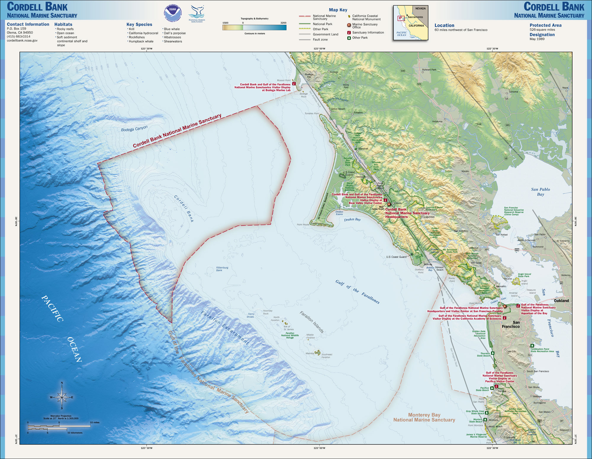
The banks northwest of Fanny Shoal are not considered part of the Farallon Islands anymore, and they are outside of U.S. territorial waters. About 25 km northwest of Fanny Shoal is Cordell Bank, a significant marine habitat (38°01′N 123°25′W / 38.017°N 123.417°W). About halfway between Fanny Shoal and Cordell Bank is Rittenburg Bank, with depths of less than 80 meters (37°53′N 123°18′W / 37.883°N 123.3°W).
Fauna and flora
 Common Murre colony on the Farallones.
Seabirds
The Farallon Islands are an important reserve protecting a huge seabird colony. The islands' position in the highly productive California Current and Eastern Pacific upwelling region, as well as the absence of other large islands that would provide suitable nesting grounds, result in a seabird population of over 250,000. Twelve species of seabird and shorebird nest on the islands; Western Gull, Brandt's Cormorant, Pelagic Cormorant, Double-crested Cormorant, Pigeon Guillemot, Common Murre, Cassin's Auklet, Tufted Puffin, Black Oystercatcher, Rhinoceros Auklet, Ashy Storm-petrel, and Leach's Storm-petrel. Since the islands were protected, Common Murres, which once numbered nearly 500,000 pairs but suffered from the egg collecting, oil spills and other disturbances which had greatly reduced their numbers, recovered and climbed from 6,000 birds to 160,000. Additionally, since protection, the locally extinct Rhinoceros Auklet has begun to breed on the islands again. The island has the world's largest colonies of Western Gulls and Ashy Storm-petrels, the latter species being considered endangered and a conservation priority. The island also is the wintering ground of several species of migrants, and regularly attracts vagrant birds (about 400 species of bird have been recorded on or around the island).
Seals
Five species of pinniped come to shore on the islands, and in some cases breed. These are the Northern Elephant Seal, Harbor Seal, Steller's Sea Lion, California Sea Lion, and the Northern Fur Seal (the last of which, like the Rhinoceros Auklet, began to return to the island again after protection).
Whales
Several species of cetaceans are found near the Farallon Islands, most frequently Gray whales, Blue whales, and Humpback whales. Blue whales and Humpback whales are most frequently found near the islands in the summer and fall, when strong upwelling may support a rich pelagic food web. Killer whales are also found around the islands. Gray whales are reliably found near the Farallones during their spring migration north and the fall/winter migration south. Some Gray whales may also be found during the summer, when a few whales skip the trip north to Alaska and spend the summer months off the coast of Canada and the continental United States
In December 2005 one Humpback was rescued from netting entanglement east of the Farallones by staff of The Marine Mammal Center.[14] The last sighting of another famous humpback, named Humphrey, was near the Farallones in 1991. The islands are in the Gulf of the Farallones National Marine Sanctuary, which protects the feeding grounds of the wildlife of the refuge.
Sharks
The elephant seal population attracts a population of Great White Sharks to the islands. In 1970 Farallon biologists witnessed their first shark attack, on a Steller’s sea lion. During the next fifteen years, more than one hundred attacks on seals and sea lions were observed at close range. By the year 2000, biologists were logging almost eighty attacks in a single season.[15]
While the males return annually, the females return only every other year, often with fresh, deep bites around their heads. The seasonal shark population at the Farallones is unclear, with estimates from thirty to one hundred. The Farallones are unique in the size of the Great Whites that are attracted. The average length of a full-grown great white shark is 4 to 4.8 metres (13.3 to 15.8 ft), with a weight of 680 to 1,100 kilograms (1,500 to 2,450 lbs), females generally being larger than males. Farallon Great Whites range between the "smaller" males at 13 ft (4.0 m) to the females which generally range between 17 ft (5.2 m) to 19 ft (5.8 m) — the largest accurately measured great white shark was a female caught in August 1988 at Prince Edward Island off the North Atlantic coast and measured 20.3 ft (6.2 m). A Killer Whale has been recorded on tape killing a Great White shark.[16]
Some individual sharks have been tagged and found to roam the Pacific as far as Hawaii, returning regularly to the Farallones every year in the autumn.[17]
Nuclear waste dump
 In the above map the approximate locations of two major nuclear waste dumping sites, according to a 1980 United States Environmental Protection Agency report, are indicated.
From 1946 to 1970, the sea around the Farallones was used as a nuclear dumping site for radioactive waste under the authority of the Atomic Energy Commission at a site known as the Farallon Island Nuclear Waste Dump. Most of the dumping took place before 1960, and all dumping of radioactive wastes by the United States was terminated in 1970. By then, 47,500 55 gallon steel drum containers had been dumped in the vicinity, with a total estimated radioactive activity of 14,500 Ci. The materials dumped were mostly laboratory materials containing traces of contamination. Much of the radioactivity had decayed by 1980.[18]
44,000 containers were dumped at 37°37′N 123°17′W / 37.617°N 123.283°W, and another 3,500 at 37°38′N 123°08′W / 37.633°N 123.133°W.[18]
The exact location of the containers and the potential hazard the containers pose to the environment are unknown.[19] Attempts to remove the barrels would likely produce more of a risk than leaving them undisturbed.[18]
Waste containers were shipped to Hunters Point Shipyard, then loaded onto barges for transportation to the Farallones. Containers were weighted with concrete. Those that floated were sometimes shot with rifles to sink them.[20]
See also
- Case of the Channel Islands of California (History).
References
- ^ "National Register Information System". National Register of Historic Places. National Park Service. 2009-03-13. http://nrhp.focus.nps.gov/natreg/docs/All_Data.html.
- ^ http://www.prbo.org/cms/171
- ^ US Fish and Wildlife Service-Wilderness Areas on National Wildlife Refuges
- ^ Federal Register Vol. 70, No. 103, Tuesday, May 31, 2005, Notices, p. 2
- ^ Thompson, R. A. (1896). The Russian Settlement in California Known as Fort Ross, Founded 1812...Abandoned 1841: Why They Came and Why They Left. Santa Rosa, California: Sonoma Democrat Publishing Company. p. 7. ISBN 0559893426. http://books.google.com/?id=-v_J7UtEtkgC&dq=R.+A.+Thompson+fort+ross&q=fur+seal#v=snippet&q=fur%20seal.
- ^ Hubert Howe Bancroft (1886). Albatross, Log-book of a Voyage to the Northwest Coast in the Years 1809-1812, Kept by Wm. Gale, MS in History of California: 1801-1824. A.L. Bancroft & Company. pp. 93–94. http://books.google.com/?id=lgETAAAAYAAJ&pg=PA275&lpg=PA275&dq=captain+smith+albatross&q=albatross. Retrieved Apr. 9, 2010.
- ^ Freeman Hunt (1846). "First Trading Settlement on the Columbia River". Merchants' Marine and Commercial Review, Volume 14 (New York): 202. http://books.google.com/?id=XoUEAAAAQAAJ&pg=PA580&lpg=PA580&dq=Merchants%27+Magazine+xiv&q=albatross. Retrieved Apr. 9, 2010.
- ^ White, Peter (1995). The Farallon Islands: Sentinels of the Golden Gate. San Francisco, California: Scottwall Associates. ISBN 0-942087-10-0.
- ^ Auguste Duhaut-Cilly (1997). August Fruge, Neal Harlow. ed. A Voyage to California, the Sandwich Islands, and Around the World in the Years 1826-1829. Berkeley and Los Angeles, California: University of California Press. p. 123. ISBN 9780520217522. http://books.google.com/?id=dF7BSXx_sW4C&printsec=frontcover&dq=A+Voyage+to+California,+the+Sandwich+Islands,+and+Around+the+World+in+the+Years+1826-1829#v=onepage&q=farallon&f=false. Retrieved 2011-09-20.
- ^ www.callofthesea.org
- ^ U.S. Fish & Wildlife Service
- ^ Wilderness.net-Farallon Wilderness
- ^ Channel Islands National Marine Sanctuary. "Shipwreck Database: Vessel Noonday". National Oceanic and Atmospheric Administration (NOAA). http://channelislands.noaa.gov/shipwreck/dbase/gfmns/noonday.html. Retrieved 2009-08-25.
- ^ Fimrite, Peter (December 14, 2005). "Daring rescue of whale off Farallones". The San Francisco Chronicle. http://www.sfgate.com/cgi-bin/article.cgi?f=/c/a/2005/12/14/MNGNKG7Q0V1.DTL.
- ^ Casey, Susan (2005). "Introduction". The Devil's Teeth. New York: Holt. ISBN 080507581X.
- ^ "The Whale That Ate Jaws". Nature Untamed - National Geographic Channel. http://channel.nationalgeographic.com/series/nature-untamed/4669/Overview#tab-Overview. Retrieved 2010-11-22.
- ^ Casey, Susan (2005). The Devil's Teeth. New York: Holt. p. 171. ISBN 080507581X.
- ^ a b c Office of Radiation Programs (14 August 1980). Radioactive Waste Dumping Off the Coast of California, Fact Sheet. U.S. Environmental Protection Agency. pp. 2, 6. https://portal.navfac.navy.mil/portal/page/portal/navfac/navfac_ww_pp/navfac_navfacsw_pp/environmental/resources-assess/hps-hra/hps-hra-1243.pdf. Retrieved 2009-08-24.
- ^ U.S. Geological Survey (22 July 2009). "Farallon Island Radioactive Waste Dump". U.S. Department of the Interior. http://walrus.wr.usgs.gov/farallon/radwaste.html. Retrieved 2009-08-25.
Further reading
- White, Peter; (1995), The Farallon Islands: Sentinels of the Golden Gate, San Francisco: Scottwall Associates, ISBN 0-942087-10-0
- Casey, Susan; (2005), The Devils Teeth: A True Story of Obsession and Survival Among America's Great White Sharks, New York: Henry Holt and Co., ISBN 0-8050-7581-X
External links
- Farallon Islands National Wildlife Refuge USFWS
- Satellite map and NOAA Chart of Farallon Islands on BlooSee
- Farallon Islands San Francisco Chronicle article.
- Farallon Islands at the Center for Land use Interpretation
- Article about nuclear waste at the Farallons
- farallones.org
- Area figures from Bureau of the Census
- The Farallon Blog Weblog of the field biologists on the Farallon Islands
- Aerial photography of the Farallones
- Live streaming video from the South East Farallon Island Courtesy California Academy of Sciences
Protected areas of California National Park System National Parks National Preserves National Monuments Cabrillo · Devils Postpile · Lava Beds · Muir Woods · Pinnacles · World War II Valor in the Pacific National MonumentNational Seashores National Historical Parks National Historic Sites National Memorials Port Chicago Naval MagazineNational Recreation Areas State Parks State Parks Ahjumawi Lava Springs · Andrew Molera · Angel Island · Annadel · Año Nuevo · Anza-Borrego Desert · Arthur B. Ripley Desert Woodland · Bidwell-Sacramento River · Big Basin Redwoods · Big River · Border Field · Bothe-Napa Valley · Burton Creek · Butano · Calaveras Big Trees · Castle Crags · Castle Rock · Caswell Memorial · China Camp · Chino Hills · Clear Lake · Crystal Cove · Cuyamaca Rancho · D. L. Bliss · Del Norte Coast Redwoods · Donner Memorial · Eastshore · El Escorpion · Emerald Bay · Fort Ord Dunes · Fremont Peak · Garrapata · Gaviota · Great Valley Grasslands · Grizzly Creek Redwoods · Grover Hot Springs · Hendy Woods · Henry Cowell Redwoods · Henry W. Coe · Humboldt Lagoons · Humboldt Redwoods · Jedediah Smith Redwoods · Julia Pfeiffer Burns · Leo Carrillo · Limekiln · MacKerricher · Malibu Creek · Manchester · McArthur-Burney Falls Memorial · Mendocino Headlands · Mendocino Woodlands · Montaña de Oro · Morro Bay · Mount Diablo · Mount San Jacinto · Mount Tamalpais · Navarro River Redwoods · Pacheco · Palomar Mountain · Patrick's Point · Pfeiffer Big Sur · Placerita Canyon · Plumas-Eureka · Point Mugu · Portola Redwoods · Prairie Creek Redwoods · Red Rock Canyon · Richardson Grove · Rio de Los Angeles · Robert Louis Stevenson · Russian Gulch · Saddleback Butte · Salt Point · Samuel P. Taylor · San Bruno Mountain · San Simeon · Sinkyone Wilderness · South Yuba River · Sugar Pine Point · Sugarloaf Ridge · Sutter Buttes · The Forest of Nisene Marks · Tolowa Dunes · Tomales Bay · Topanga · Van Sickle · Van Damme · Washoe Meadows · Wilder RanchState Reserves Año Nuevo · Antelope Valley California Poppy · Armstrong Redwoods · Azalea · Caspar Headlands · John B. Dewitt · John Little · Jug Handle · Kruse Rhododendron · Los Osos Oaks · Mailliard Redwoods · Mono Lake Tufa · Montgomery Woods · Point Lobos · Smithe Redwoods · Torrey Pines · Tule ElkState Marine Reserves State Historic Parks Anderson Marsh · Antelope Valley Indian Museum · Bale Grist Mill · Benicia Capitol · Bidwell Mansion · Bodie · California Citrus · California State Indian Museum · Chumash Painted Cave · Colonel Allensworth · Columbia · Cowell Ranch/John Marsh · El Presidio de Santa Barbara · Empire Mine · Folsom Powerhouse · Fort Humboldt · Fort Ross · Fort Tejon · Governor's Mansion · Hearst San Simeon · Indian Grinding Rock · Jack London · La Purísima Mission · Leland Stanford Mansion · Los Angeles · Los Encinos · Malakoff Diggins · Marconi Conference Center · Marshall Gold Discovery · Monterey · Old Sacramento · Old Town San Diego · Olompali · Petaluma Adobe · Pigeon Point Light Station · Pío Pico · Point Sur · Railtown 1897 · San Juan Bautista · San Pasqual Battlefield · Santa Cruz Mission · Santa Susana Pass · Shasta · Sonoma · Sutter's Fort · Tomo-Kahni · Wassama Round House · Watts Towers of Simon Rodia · Weaverville Joss House · Will Rogers · William B. Ide Adobe · Woodland Opera HouseState Beaches Asilomar · Bean Hollow · Bolsa Chica · Cardiff · Carlsbad · Carmel River · Carpinteria · Caspar Headlands · Cayucos · Corona del Mar · Dockweiler · Doheny · El Capitán · Emma Wood · Gray Whale Cove · Greenwood · Half Moon Bay · Huntington · Leucadia · Lighthouse Field · Little River · Malibu Lagoon · Mandalay · Manresa · Marina · McGrath · Montara · Monterey · Moonlight · Morro Strand · Moss Landing · Natural Bridges · New Brighton · Pacifica · Pelican · Pescadero · Pismo · Point Dume · Point Sal · Pomponio · Refugio · Robert H. Meyer Memorial · Robert W. Crown Memorial · Salinas River · San Buenaventura · San Clemente · San Elijo · San Gregorio · San Onofre · Santa Monica · Schooner Gulch · Seacliff · Silver Strand · Sonoma Coast · South Carlsbad · Sunset · Thornton · Torrey Pines · Trinidad · Twin Lakes · Westport-Union Landing · Will Rogers · William Randolph Hearst Memorial · ZmudowskiState Recreation Areas Admiral William Standley · Auburn · Austin Creek · Benbow Lake · Benicia · Bethany Reservoir · Brannan Island · Candlestick Point · Castaic Lake · Colusa-Sacramento River · Folsom Lake · Franks Tract · George J. Hatfield · Harry A. Merlo · Kenneth Hahn · Kings Beach · Lake Del Valle · Lake Oroville · Lake Perris · Lake Valley · McConnell · Millerton Lake · Picacho · Providence Mountains · Salton Sea · San Luis Reservoir · Silverwood Lake · Standish-Hickey · Tahoe · Turlock Lake · Woodson BridgeState Vehicular Recreation Areas Carnegie · Clay Pit · Heber Dunes · Hollister Hills · Hungry Valley · Oceano Dunes · Ocotillo Wells · Prairie CityOther Burleigh H. Murray Ranch · California Mining and Mineral Museum · California State Capitol Museum · California State Railroad Museum · Castro Adobe · Delta Meadows · Estero Bay · Hatton Canyon · Indio Hills Palms · Marital Cottle Project · Point Cabrillo Light Station · Point Lobos Ranch · Point Montara Light Station · Reynolds Wayside Campground · San Timoteo Canyon · Stone Lake · Verdugo Mountains · Ward Creek · Wildwood CanyonNational Forests National Forests Angeles · Cleveland · Eldorado · Inyo · Klamath · Lassen · Los Padres · Mendocino · Modoc · Plumas · San Bernardino · Sequoia · Shasta-Trinity · Sierra · Six Rivers · Stanislaus · TahoeNational Wilderness
Preservation SystemAgua Tibia · Ansel Adams · Bucks Lake · Caribou · Carson-Iceberg · Castle Crags · Cucamonga · Desolation · Dick Smith · Dinkey Lakes · Emigrant · Golden Trout · Hoover · Inyo Mountains · Ishi · Jennie Lakes · John Muir · Kaiser · Marble Mountain · Mokelumne · Mount Shasta Wilderness · North Fork · San Gabriel · Sanhedrin · San Jacinto · San Rafael · Sespe · Siskiyou · Snow Mountain · South Fork Eel River · South Sierra · South Warner · Thousand Lakes · Trinity Alps · Ventana · Yolla Bolly-Middle Eel · YukiOther State Forests Boggs Mountain Demonstration · Ellen Pickett · Jackson Demonstration · Las Posadas · LaTour Demonstration · Mount Zion · Mountain Home Demonstration · Soquel Demonstration
National Wildlife Refuges Antioch Dunes · Bitter Creek · Blue Ridge · Butte Sink · Castle Rock · Clear Lake · Coachella Valley · Colusa · Delevan · Don Edwards San Francisco Bay · Ellicott Slough · Farallon · Guadalupe-Nipomo Dunes · Hopper Mountain · Humboldt Bay · Kern · Lower Klamath · Marin Islands · Merced · Modoc · Pixley · Sacramento · Sacramento River · Salinas River · San Diego Bay · San Diego · San Joaquin River · San Luis · San Pablo Bay · Seal Beach · Sonny Bono Salton Sea · Stone Lakes · Sutter · Tijuana Slough · Tule LakeState Wildlife Areas Wildlife Areas Antelope Valley · Ash Creek · Bass Hill · Battle Creek · Big Lagoon · Big Sandy · Biscar · Butte Valley · Buttermilk Country · Cache Creek · Camp Cady · Cantara/Ney Springs · Cedar Roughs · Cinder Flats · Collins Eddy · Colusa Bypass · Coon Hollow · Cottonwood Creek · Crescent City Marsh · Crocker Meadows · Daugherty Hill · Decker Island · Doyle · Dutch Flat · Eastlker River · Eel River · Elk Creek Wetlands · Elk River · Fay Slough · Feather River · Fitzhugh Creek · Fremont Weir · Grass Lake · Gray Lodge · Green Creek · Grizzly Island · Hallelujah Junction · Heenan Lake · Hill Slough · Hollenbeck Canyon · Honey Lake · Hope Valley · Horseshoe Ranch · Imperial · Indian Valley · Kelso Peak and Old Dad Mountains · Kinsman Flat · Knoxville · Laguna · Lake Berryessa · Lake Earl · Lake Sonoma · Little Panoche Reservoir · Los Banos · Lower Sherman Island · Mad River Slough · Marble Mountains · Mendota · Merrill's Landing · Miner Slough · Monache Meadows · Morro Bay · Moss Landing · Mouth of Cottonwood Creek · Napa-Sonoma Marshes · North Grasslands · O'Neill Forebay · Oroville · Petaluma Marsh · Pickel Meadow · Pine Creek · Point Edith · Putah Creek · Rector Reservoir · Red Lake · Rhode Island · Sacramento River · San Felipe Valley · San Jacinto · San Luis Obispo · San Luis Reservoir · San Pablo Bay · Santa Rosa · Shasta Valley · Silver Creek · Slinkard/Little Antelope · Smithneck Creek · South Fork · Spenceville · Surprise Valley · Sutter Bypass · Tehama · Truckee River · Upper Butte Basin · Volta · Warner Valley · Waukell Creek · West Hilmar · Westlker River · White Slough · Willow Creek · Yolo BypassEcological Reserves Albany Mudflats · Alkali Sink · Allensworth · Atascadero Creek Marsh · Bair Island · Baldwin Lake · Batiquitos Lagoon · Blue Sky · Boden Canyon · Boggs Lake · Bolsa Chica · Bonny Doon · Buena Vista Lagoon · Butler Slough · Butte Creek Canyon · Butte Creek House · Buttonwillow · By Day Creek · Calhoun Cut · Canebrake · Carlsbad Highlands · Carmel Bay · Carrizo Canyon · Carrizo Plains · China Point · Clover Creek · Coachella Valley · Coal Canyon · Corte Madera Marsh · Crestridge · Dairy Mart Ponds · Dales Lake · Del Mar Landing · Eden Landing · Elkhorn Slough · Estelle Mountain · Fall River Mills · Fish Slough · Fremont Valley · Goleta Slough · Indian Joe Spring · Kaweah · Kerman · King Clone · Laguna Laurel · Loch Lomond Vernal Pool · Lokern · Magnesia Spring · Marin Islands · Mattole River · McGinty Mountain · Morro Dunes · Morro Rock · Napa River · North Table Mountain · Oasis Spring · Panoche Hills · Peytonia Slough · Pine Hill · Piute Creek · Pleasant Valley · Point Lobos · Rancho Jamul · Redwood Shores · River Springs Lakes · Saline Valley · San Dieguito Lagoon · San Elijo Lagoon · San Felipe Creek · San Joaquin River · Santa Rosa Plateau · Springville · Stone Corral · Sycamore Canyon · Sycuan Peak · Thomes Creek · Tomales Bay · Upper Newport Bay · Watsonville Slough · West Mojave Desert · Woodbridge · YaudanchiMarine Protected Areas Abalone Cove · Agua Hedionda Lagoon · Albany Mudflats · Anacapa · Anacapa · Año Nuevo · Asilomar · Atascadero Beach · Bair Island · Batiquitos Lagoon · Big Creek · Big Creek · Big Sycamore Canyon · Bodega · Bolsa Chica · Buena Vista Lagoon · Cambria · Cardiff and San Elijo · Carmel Bay · Carmel Pinnacles · Carrington Point · Catalina Marine Science Center · Corte Madera Marsh · Crystal Cove · Dana Point · Del Mar Landing · Doheny · Doheny · Duxbury Reef · Edward F. Ricketts · Elkhorn Slough · Elkhorn Slough · Encinitas · Estero de Limantour · Fagan Marsh · Farallon Islands · Farnsworth Bank · Fort Ross · Gerstle Cove · Goleta Slough · Greyhound Rock · Gull Island · Harris Point · Heisler Park · Hopkins · Irvine Coast · James V. Fitzgerald · Judith Rock · Julia Pfeiffer Burns · La Jolla · Laguna Beach · Lovers Cove (Catalina Island) · Lovers Point · MacKerricher · Manchester and Arena Rock · Marin Islands · Mia J. Tegner · Moro Cojo Slough · Morro Bay · Morro Bay · Morro Beach · Natural Bridges · Niguel · Pacific Grove Marine Gardens · Painted Cave · Peytonia Slough · Piedras Blancas · Piedras Blancas · Pismo · Pismo-Oceano Beach · Point Buchon · Point Buchon · Point Cabrillo · Point Fermin · Point Lobos · Point Reyes Headlands · Point Sur · Point Sur · Portuguese Ledge · Punta Gorda · Redwood Shores · Refugio · Richardson Rock · Robert E. Badham · Robert W. Crown · Russian Gulch · Russian River · Salt Point · San Diego-Scripps · San Dieguito Lagoon · San Elijo Lagoon · Santa Barbara Island · Scorpion · Skunk Point · Sonoma Coast · Soquel Canyon · South Laguna Beach · South Point · Tomales Bay · Upper Newport Bay · Van Damme · Vandenberg · White Rock (Cambria)National Landscape Conservation System National Monuments National Conservation Areas California Desert · King RangeWilderness Areas Argus Range · Big Maria Mountains · Bigelow Cholla Garden · Bighorn Mountain · Black Mountain · Bright Star · Bristol Mountains · Cadiz Dunes · Carrizo Gorge · Chemehuevi Mountains · Chimney Peak · Chuckwalla Mountains · Chumash · Cleghorn Lakes · Clipper Mountain · Coso Range · Coyote Mountains · Darwin Falls · Dead Mountains · Dick Smith · El Paso Mountains · Fish Creek Mountains · Funeral Mountains · Golden Valley · Grass Valley · Headwaters Forest Reserve · Hollow Hills · Ibex · Indian Pass · Inyo Mountains · Jacumba · Kelso Dunes · Kiavah · Kingston Range · Little Chuckwalla Mountains · Little Picacho · Machesna Mountain · Matilija · Malpais Mesa · Manly Peak · Mecca Hills · Mesquite · Newberry Mountains · Nopah Range · North Algodones Dunes · North Mesquite Mountains · Old Woman Mountains · Orocopia Mountains · Otay Mountain · Owens Peak · Pahrump Valley · Palen/McCoy · Palo Verde Mountains · Picacho Peak · Piper Mountain · Piute Mountains · Red Buttes · Resting Spring Range · Rice Valley · Riverside Mountains · Rodman Mountains · Sacatar Trail · Saddle Peak Hills · San Gorgonio · Santa Lucia · Santa Rosa · Sawtooth Mountains · Sespe · Sheephole Valley · South Nopah Range · Stateline · Stepladder Mountains · Surprise Canyon · Sylvania Mountains · Trilobite · Turtle Mountains · Whipple Mountains ·National Marine Sanctuaries National Estuarine Research Reserves Elkhorn Slough · San Francisco Bay · Tijuana River Estuary
University of California Natural Reserve System Año Nuevo Island · Bodega Marine · Box Springs · Boyd Deep Canyon Desert Research Center · Burns Piñon Ridge · Carpinteria Salt Marsh · Chickering American River · Coal Oil Point · Dawson Los Monos Canyon · Eagle Lake Field Station · Elliott Chaparral · Emerson Oaks · Fort Ord · Hastings · James San Jacinto Mountains · Jenny Pygmy Forest · Jepson Prairie · Kendall-Frost Mission Bay Marsh · Kenneth S. Norris Rancho Marino · Landels-Hill Big Creek · McLaughlin · Motte Rimrock · Quail Ridge · Sagehen Creek Field Station · San Joaquin Freshwater Marsh · Santa Cruz Island · Scripps Coastal · Sedgwick · Stebbins Cold Canyon · Steele Burnand Anza-Borrego · Stunt Ranch Santa Monica Mountains · Sweeney Granite Mountains Desert Research Center · Valentine Eastern Sierra · Younger LagoonHeritage registers: World Heritage Sites · World Network of Biosphere Reserves · National Register of Historic Places · National Historic Landmarks · National Natural Landmarks · California Historical Landmarks · California Points of Historical Interest · California Register of Historical Resources
U.S. National Register of Historic Places Topics Lists by states Alabama • Alaska • Arizona • Arkansas • California • Colorado • Connecticut • Delaware • Florida • Georgia • Hawaii • Idaho • Illinois • Indiana • Iowa • Kansas • Kentucky • Louisiana • Maine • Maryland • Massachusetts • Michigan • Minnesota • Mississippi • Missouri • Montana • Nebraska • Nevada • New Hampshire • New Jersey • New Mexico • New York • North Carolina • North Dakota • Ohio • Oklahoma • Oregon • Pennsylvania • Rhode Island • South Carolina • South Dakota • Tennessee • Texas • Utah • Vermont • Virginia • Washington • West Virginia • Wisconsin • WyomingLists by territories Lists by associated states Other Categories:- IUCN Category IV
- Landforms of San Francisco, California
- Islands of California
- Islands of the San Francisco Bay Area
- National Register of Historic Places in San Francisco, California
- National Wildlife Refuges in California
- Seabird colonies
- Protected areas of San Francisco, California


Wikimedia Foundation. 2010.