- Dulwich Hill, New South Wales
-
Dulwich Hill
Sydney, New South Wales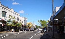
Population: 12,469 (2001 census) Established: 1892 Postcode: 2203 Area: 2.1 km² (0.8 sq mi) Location: 9 km (6 mi) south-west of Sydney CBD LGA: Marrickville Council State District: Marrickville, Canterbury Federal Division: Grayndler Suburbs around Dulwich Hill: Summer Hill Lewisham Petersham Hurlstone Park Dulwich Hill Marrickville Earlwood Undercliffe Marrickville South Dulwich Hill is a residential suburb in the Inner West of Sydney, in the state of New South Wales, Australia. Dulwich Hill is located 9 kilometres south-west of the Sydney central business district, in the local government area of Marrickville Council. Dulwich Hill stretches south to the shore of the Cooks River.[1]
Contents
History
The suburb takes its name from the area of Dulwich in London. The name Dulwich Hill appears in Sand's Directory of 1892. It had been known by several different names prior to this. Following European settlement, it was called Petersham Hill. It later took the name Wardell's Bush, a reference to Dr Robert Wardell, one of the area's early landowners. Other names the area was given were South Petersham and Fern Hill.[2]
 Gladstone Hotel, Dulwich Hill
The area became part of Sydney's expanding tram network in 1889 and, like many suburbs in the inner-west, experienced rapid growth in the early twentieth century. As a consequence, the suburb has a large number of examples of Australian Federation architecture. It also features examples of Edwardian, Gothic and Italianate architecture. The tramway ran up until 1957.
Listed on the Register of the National Estate is the former public school in Seaview Street, which now operates as the Dulwich Hill High School of Visual Arts and Design. The building was designed by W.E.Kemp in the Romanesque style and built circa 1892.[3] Situated in the same street is the Dulwich Hill Library, a converted cottage in the Victorian Gothic style.
Commercial area
Dulwich Hill features two shopping areas, a small number of shops on Wardell Road near Dulwich Hill railway station and the main shopping area around the northern end of Marrickville Road and its intersection with New Canterbury Road. The Marrickville Road shopping area centred on the former tram line (now replaced by buses), and continues onto New Canterbury Road. In the 1990s many shops were vacant, but in recent years most shops have tenants with thriving businesses. Cafés and restaurants have become popular as the suburb becomes gentrified. Marrickville Council upgraded the shopping strip in the early 2000s, enhancing the look and character of the area. Dulwich Hill has a library (a branch of Marrickville Library) and a post office, but was never chartered a town hall or police station (the nearest is Marrickville Local Area Command).
Education
 Dulwich High School of Visual Arts and Design
Dulwich Hill contains three primary schools: Dulwich Hill Public School in Kintore Street, St Marouns College in Wardell Road and St Paul of the Cross, a Catholic school in New Canterbury Road, as well as one secondary school, Dulwich High School of Visual Arts & Design in Seaview Street. Dulwich High School was the first Visual Arts School in Australia.[4]
Notable graduates of the high school include former Parramatta rugby league coach Terry Fearnley, tennis player Phil Dent and opera singer Yvonne Minton, while former rugby league referee Jack Danzey taught there.[5]
Transport
Tram history
Main article: Trams in SydneyUntil the late 1950s, when the local tramway system was closed, electric trams ran to Dulwich Hill and the Cooks River from Circular Quay. The line to Dulwich Hill branched from the Cooks River line at Newtown, turning off King Street into Enmore Road,[6] travelling through Marrickville and Dulwich Hill, via Victoria and Marrickville Roads.[7] A tram tuning loop was provided at the Canterbury Road terminus.[8]
Modern transport
 Waratah Mills and light rail corridor
Modern public transport to the area comprises a station on the electric metropolitan railway and several routes serviced by natural gas and diesel Government buses. A light rail route is under planning.
Dulwich Hill railway station is located on Wardell Road, in the southern part of the suburb. The station is serviced by the Bankstown railway line of the CityRail network which provides reasonably frequent services to the Sydney CBD and south-western suburbs. Travelling west, residents can visit Bankstown and beyond to Liverpool and Lidcombe (a junction servicing several lines).
The 426, 428, 418, 444/445 and 412 bus routes run through Dulwich Hill. The suburb's main bus route, 426, starts at the corner of Marrickville and New Canterbury Roads and runs along Marrickville Road towards Marrickville. The 428 service runs from Canterbury Station along New Canterbury Road towards Petersham. Both these services go to the Sydney CBD via Newtown, terminating at Circular Quay. The 418 between Tempe and Burwood via Ashfield follows the same route as 426 between Marrickville and Dulwich Hill shops, before swinging on to New Caterbury Rd, and then south to Hurlstone Park Station. The 444/445 routes run from Campsie Station to Balmain via Leichhardt, following the same route as the 428 through Dulwich Hill. The 412 runs from Campsie to King Street Wharf in the city. It comes up Wardell Road, passing Dulwich Hill railway station, before running along the south side of the railway and proceeding up Livingstone Road towards Marrickville and Petersham.[9]
The current light rail service that runs from Central Station to Lilyfield is now being extended to Dulwich Hill, making use of a disused heavy rail freight line.[10][11] There will be four new stations located in Dulwich Hill. These are - Dulwich Hill Interchange (adjacent to the railway station), Dulwich Grove (between New Canterbury Road and Hercules Street with access being gained from both streets), Arlington (adjacent to Johnson Park near Constitution Road) and Waratah Mills (near Davis Street). Access to the city will be quicker by train, but the light rail may be used for some cross-regional journeys. The service will also interchange with Lewisham railway station on the Inner West Line.
Demographics
In the 20th Century, much of Dulwich Hill was shaped by immigrants from Greece (particularly closer to Marrickville) and Portugal (particularly closer to Petersham). More recent arrivals include those from Pacific Island nations, China and Vietnam. Today, fewer migrants (and their descendants) live and own businesses in Dulwich Hill. More families and young urban professionals have been attracted to the suburb by its proximity to the Sydney CBD and multicultural lifestyle.
Governance
Residents of Dulwich Hill elect representatives to federal, state and local governments. At the federal level, it is in the electoral division of Grayndler, currently held by Anthony Albanese, of the Australian Labor Party (ALP), who was last re-elected in the 2007 General Election and has been named as a member of the Cabinet in the Rudd Government as the Minister for Infrastructure, Transport, Regional Development and Local Government.[12] The seat of Grayndler has been held continuously by the ALP since it was proclaimed in 1949.[13]
At the state level, Dulwich Hill is predominantly in the Electoral district of Marrickville, held by the ALP's Carmel Tebbutt, who was formerly a senior minister in the NSW Government but moved to the backbench after the 2007 election to spend more time with her young son. Residents on the western side of Dulwich Hill are in the Electoral district of Canterbury, held by Linda Burney, also an ALP member, and currently Minister for Fair Trading. Previously, Dulwich Hill had been part of the Electoral district of Ashfield but that was abolished in 1999.[14][15]
At the local level, Dulwich Hill is in the west ward of Marrickville Council, represented by three councillors: Marika Kontellis, a member of the Australian Greens, Dimitrios Thanos, a local dentist and independent councillor first elected in 1999, and Emanuel Tsardoulias from the Australian Labor Party.[16][17][18]
Sport and recreation
Arlington Recreation Ground in Williams Parade is home to the Dulwich Hill FC soccer club, which plays in the NSW Super League, the second tier of senior soccer in Sydney, and also the Stanmore Hawks soccer club which plays in the NSW State League Division One, the third tier.
Gallery
Houses
Dulwich Hill is an established residential area with many examples of Federation architecture[citation needed]. The streets are wider than many inner-city suburbs and houses are bigger than some older, neighbouring suburbs such as Petersham[citation needed]. However, the area is also zoned for medium-density housing, with several blocks of flats having been built in the last forty years[citation needed].
-
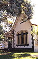
Dulwich Hill Library, Seaview Street
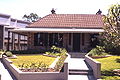
-

Restored Victorian home, Marrickville Road
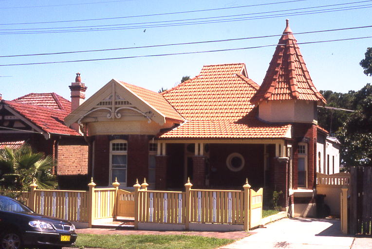
-

Federation Queen Anne cottage, Challis Avenue, showing characteristic woodwork, circular window and turret
-
Sandstone Colonial-style home, Ewart Street
Churches
The area is served by several religious organisations, including Anglican, Catholic and Greek Orthodox churches.
-

St Marouns Catholic Monastery
-

St Paul of the Cross Catholic Church
References
- ^ Gregory's Sydney Street Directory, Gregory's Publishing Company, 2008
- ^ "History of Suburbs". Marrickville Council. http://www.marrickville.nsw.gov.au/community/history/suburbs.htm. Retrieved 2007-08-29.
- ^ The Heritage of Australia, Macmillan Company, 1981
- ^ Dulwich High School website
- ^ Meader C, Cashman R, Carolan A (1994). Marrickville:People and Places. Marrickville: Hale and Ironmonger. p. 119. ISBN 0-86806-559-5.
- ^ 1950's Gregory's street directory, map 9, F 4
- ^ 1950's Gregory's street directory, map 28, H 13
- ^ 1950's Gregory's street directory, map 33, E 2
- ^ Sydney Buses Southern Region Guide (March 2010)
- ^ http://www.transport.nsw.gov.au/sites/default/file/rail/Sydney-Light-Rail-Inner-West-Extension-Draft-Report.pdf
- ^ http://www.transport.nsw.gov.au/sites/default/file/rail/Sydney-Light-Rail-Inner-West-Extension-Draft-Appendices.pdf
- ^ "Rudd hands out portfolios". Australian Broadcasting Corporation. http://www.abc.net.au/news/stories/2007/11/29/2105169.htm?site=elections/federal/2007.
- ^ "Grayndler". Australian Electoral Commission. http://www.aec.gov.au/profiles/g/grayndler.htm. Retrieved 2007-08-29.
- ^ "Marrickville". Elections NSW. http://www.elections.nsw.gov.au/__data/assets/image/0010/2206/marrickville_a3_nl.gif. Retrieved 2007-08-29.
- ^ "Parenthood is still the mother of all guilt trips". Sydney Morning Herald. 31 March 2007. http://www.smh.com.au/news/opinion/parenthood-is-still-the-mother-of-all-guilt-trips/2007/03/30/1174761750890.html. Retrieved 2007-08-29.
- ^ "Your councillors - Clr Marika Kontellis". Marrickville Council. http://www.marrickville.nsw.gov.au/council/councillors/mkontellis.htm. Retrieved 2010-04-18.
- ^ "Your councillors - Clr Emanuel Tsardoulias". Marrickville Council. http://www.marrickville.nsw.gov.au/council/councillors/etsardoulias.htm. Retrieved 2010-04-18.
- ^ "Your councillors - Clr Dimitrios Thanos". Marrickville Council. http://www.marrickville.nsw.gov.au/council/councillors/dthanos.htm. Retrieved 2007-08-29.
- Snapshot: Dulwich Hill, Sydney Morning Herald, 25 October 2005.
External links
- Dulwich Hill, New South Wales is at coordinates 33°54′30″S 151°08′30″E / 33.9083°S 151.1416°ECoordinates: 33°54′30″S 151°08′30″E / 33.9083°S 151.1416°E
- Australian Electoral Commission profile of Grayndler
- Geographical Names Board of NSW suburb boundary map
- Marrickville Council - History of Suburbs
- Dulwich Hill Community
Suburbs and localities within Marrickville Council · Inner West · Sydney Camperdown · Dulwich Hill · Enmore · Lewisham · Marrickville · Marrickville South · Newtown · Petersham · St Peters · Stanmore · Sydenham · Tempe
Categories:- Suburbs of Sydney
-


Wikimedia Foundation. 2010.