- Glen Cove Road
-
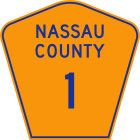 Glen Cove Road was once signed as Nassau County Route 1 until all county route numbers were removed in the 1970s.[1]
Glen Cove Road is a major north–south thoroughfare through north-central Nassau County on Long Island, New York, and the main road leading to the communities on the east shore of Hempstead Harbor. The portion south of the North Hempstead/Oyster Bay town line is the unsigned Nassau County Route 1, while the portion north of the town line until its intersection with Route 107 is designated as New York State Route 900B, an unsigned reference route.
Contents
Route description
The alignment of Glen Cove Road starts at Peninsula Boulevard in downtown Hempstead, but is known as Clinton Road until its intersection with Old Country Road in Carle Place.[2] It curves from when it intersects with NY 25 to I-495 to steer clear of the Meadowbrook Parkway and the Northern Parkway. Within Old Westbury the road is concurrently signed as Guinea Woods Road.[2]
Soon after its intersection with NY 25A in Greenvale, it widens to a divided highway and assumes the NY 900B designation, although the reference markers refer to it as NY 904.[3] At its intersection with NY 107 the alignment assumes that route's number and name.[2] After another 1.4 miles (2.3 km) the divided highway alignment and the NY 107 designation forks to the left as Pratt Boulevard while Cedar Swamp Road forks to the right as a surface street. The road eventually ends at its intersection with Brewster Street near downtown Glen Cove.
History
Glen Cove Road was once (as of 1959) part of an extended County Route 1 which reached as far south as Point Lookout and as far north as Centre Island.[4] The current state designation for the route only includes the Clinton Road and Glen Cove Road alignment south of the North Hempstead/Oyster Bay town line, after which it becomes NY 900B and later New York State Route 107. Route 900B had originally been NY 904 prior to the creation of the modern reference route system.[5] The county route signage was removed in the mid-1970s because the county did not want to pay to replace the signs to conform to new federal standards.[1]
The northernmost segment of NY 107, known as the Glen Cove Arterial Highway, clearly had limited-access aspirations. In the mid-1960s, this segment was constructed as a bypass of Glen Street, likely as the approach for one of two proposed bridges to Rye, New York across the Long Island Sound.
Major intersections
- Note: The mileages below only cover the portion actually signed as Glen Cove Road.
The entire route is in Nassau County.Location Mile Destinations Notes Village of Hempstead Peninsula Boulevard  NY 24 (Hempstead Turnpike)
Garden City Stewart Avenue Carle Place 0.0 Old Country Road Changes name from Clinton Road to Glen Cove Road 1.4  Northern Parkway
Exit 31 (Northern Parkway) Old Westbury 1.5  NY 25 (Jericho Turnpike)
1.8  NY 25B (Hillside Avenue)
3.2 I.U. Willets Road 4.1  I-495 (Long Island Expressway)
Exit 39 (I-495) East Hills 4.7 Harbor Hill Road Greenvale 6.5  NY 25A (Northern Boulevard)
Glen Head 9.6  NY 107 south (Cedar Swamp Road) / Glen Head Road
Alignment assumes Cedar Swamp Road name and 107 route number 11.0 Cedar Swamp Road / Sea Cliff Avenue Alignment assumes Pratt Boulevard name, keeping 107 route number Glen Cove Brewster Street / Glen Cove Avenue 1.000 mi = 1.609 km; 1.000 km = 0.621 mi See also
- List of county routes in Nassau County, New York
- List of New York State Reference Routes and Parkway Routes
References
- ^ a b Anderson, Steve. "County Roads on Long Island". NYCRoads. http://www.nycroads.com/roads/county-history/. Retrieved January 3, 2008.
- ^ a b c Google Maps (2008). Overview map of Glen Cove Road (Map). http://maps.google.com/maps?hl=en&rlz=1T4ADBF_enUS232US232&q=from:+Clinton+St+%4040.706811,+-73.618630+to:+Glen+Cove+Ave+%4040.862747,+-73.633663&um=1&ie=UTF-8&sa=N&tab=wl. Retrieved January 3, 2008.
- ^ "Traffic Data Report - All routes" (PDF). NYSDOT. July 16, 2007. https://www.nysdot.gov/divisions/engineering/technical-services/hds-respository/NYSDOT_Traffic_Data_Report_2006.pdf. Retrieved January 3, 2008.
- ^ Anderson, Steve. "County Roads in Nassau County - Routes 1 - 25". NYCRoads. http://www.nycroads.com/roads/nassau_001-025/. Retrieved January 3, 2008.
- ^ Anderson, Steve. "State and U.S. Routes on Long Island". NYCRoads. http://www.nycroads.com/roads/state_long-island/. Retrieved January 3, 2008.
Categories:- Roads in New York
- Transportation in Nassau County, New York

Wikimedia Foundation. 2010.