- Kvarken
-
High Coast / Kvarken Archipelago * UNESCO World Heritage Site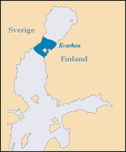
Country Finland and Sweden Type Natural Criteria viii Reference 898 Region ** Europe and North America Inscription history Inscription 2000 (24th Session) Extensions 2006 * Name as inscribed on World Heritage List
** Region as classified by UNESCOKvarken (alternative spelling Quarken, Swedish Kvarken or Norra Kvarken (as opposed to South Kvarken), Finnish Merenkurkku) is the narrow region in the Gulf of Bothnia separating the Bothnian Bay (the inner part of the gulf) from the Bothnian Sea. The distance from Swedish mainland to Finnish mainland is around 80 km while the distance between the outmost islands is only 25 km. The water depth in the Kvarken region is only around 25 meters. The region also has an unusual rate of land rising at about 1 cm a year.
On the Finnish side of Kvarken, there is a large archipelago. Most of the small islands are inhabited. The archipelago is smaller on the Swedish side of the region, and the islands have much steeper shores. The Kvarken region was historically important also, because mail was delivered across Kvarken when the sea was completely frozen from the Swedish to the Finnish coast. This mail route was used frequently during the period of Swedish rule.
In the group of islands in the “middle” of the Kvarken region, in Swedish called Valsörarna – Finnish Valassaaret, is a 36 meter high lighthouse designed by Henry LePaute who worked for Gustave Eiffel's engineering bureau. The structural similarity between the lighthouse (built in 1885) and the Eiffel tower (built in 1889) is quite obvious. The lighthouse is now automated as are most lighthouses in Finland.
Coordinates: 63°30′N 21°0′E / 63.5°N 21°E
Contents
World Heritage Site
In 2006, the Kvarken Archipelago was added as an extension to the World Heritage Site of the High Coast (located on the western shore of the Gulf of Bothnia) in Sweden, because it is “continuously rising from the sea in a process of rapid glacio-isostatic uplift, whereby the land, previously weighed down under the weight of a glacier, lifts at rates that are among the highest in the world. As a consequence of the advancing shoreline, islands appear and unite, peninsulas expand, lakes evolve from bays and develop into marshes and peat fens. This property is essentially a ‘type area’ for research on isostasy; the phenomenon having been first recognized and studied here.”[1] Most of the World Heritage Site is situated in the Korsholm municipality.
Bridge
Main article: Kvarken BridgeThere have been proposals for a bridge across the strait, at a cost of about 1.5 to 2 billion euros. There are islands in the strait, and the sum of the lengths of the probably three bridge parts would be about 40 km. The Swedish minister of finance has said it is an interesting idea, but the idea is still decades from being brought to fruition. There is a debate in the coastal cities on both sides, like Umeå and Vaasa. The official view from the Swedish and Finnish governments is that it is much too expensive. The natural values in the area also makes a bridge dubious.
References
External links
World Heritage Sites in Finland Bronze Age Burial Site of Sammallahdenmäki · Fortress of Suomenlinna · High Coast / Kvarken Archipelago (with Sweden) · Old Rauma · Petäjävesi Old Church · Verla Groundwood and Board Mill · Struve Geodetic Arc (with nine other countries)

World Heritage Sites in Sweden For official site names, see each article or the List of World Heritage Sites in Sweden.East 
South Agricultural Landscape of Stora Alvaret (Southern Öland) · Hanseatic Town of Visby · Naval Port of Karlskrona · Rock Carvings in Tanum · Varberg Radio Station (Grimeton VLF transmitter)
North Church Village of Gammelstad, Luleå · High Coast / Kvarken Archipelago1 · Laponian Area · Mining Area of the Great Copper Mountain, Falun · Struve Geodetic Arc2
1 Shared with Finland · 2 Shared with nine other countriesCategories:- World Heritage Sites in Finland
- World Heritage Sites in Sweden
- Finnish islands in the Baltic
- Straits of Finland
- Straits of Sweden
- Landmarks in Finland
- Finland–Sweden border
- International straits

Wikimedia Foundation. 2010.