- Maryland Route 367
-
Maryland Route 367
Bishopville Road 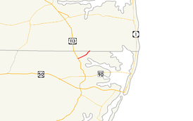
Maryland Route 367 highlighted in redRoute information Maintained by MDSHA Length: 2.60 mi[1] (4.18 km) Major junctions West end: Bishopville Road in Bishop  US 113 in Bishop
East end: Hudson Road at the Delaware state line in Bishopville Location Counties: Worcester Highway system Maryland highway system
Interstate • US • State • Minor • Former • Turnpikes←  MD 366
MD 368  →
→Maryland Route 367 (MD 367) is a state highway in the U.S. state of Maryland. Known as Bishopville Road, the state highway runs 2.60 miles (4.18 km) from the county-maintained portion of Bishopville Road in Bishop east to the Delaware state line in Bishopville. MD 367 connects U.S. Route 113 (US 113) with Bishopville and other small communities on the St. Martin Neck in northern Worcester County. The state highway was constructed between Bishop and Bishopville in two steps in the mid 1920s and early 1930s, respectively. The segment within Bishopville was constructed as part of an extended MD 368 in the mid 1910s. The portion from Bishopville to the Delaware state line was constructed in the mid 1930s as MD 568. All three state highways were reassigned to their present lengths in 1950.
Contents
Route description
MD 367 begins on the east side of the Snow Hill Line of the Maryland and Delaware Railroad in the hamlet of Bishop. Bishopville Road continues west of the railroad track as a county highway. MD 367 intersects US 113 (Worcester Highway), then continues east as a two-lane road toward Bishopville. After crossing Buntings Branch of the St. Martin River, the state highway enters Bishopville and intersects MD 368 (St. Martins Neck Road) and MD 568 (Hatchery Road), both of which are unsigned. MD 367 reaches its eastern terminus at the Delaware state line, where the highway continues northeast as Hudson Road in Sussex County.[1][2]
History
The first part of MD 367 to be paved was between present day MD 368 and MD 568 in Bishopville. That segment, plus the present lengths of MD 368 and MD 568, were paved as a state-aid road between 1912 and 1915 and later designated MD 368.[3][4] The next segment of modern MD 367 was between the western terminus and just west of Buntings Branch, which was completed by 1923.[5] The connection over Buntings Branch to MD 368 was finished by 1933.[6] The remainder of Bishopville Road to the Delaware state line was completed in 1934 and designated MD 568.[7][8][4] MD 367 was extended east from MD 368 to the Delaware state line in 1950 when MD 368 was rolled back to its present length and MD 568 was reassigned to Hatchery Road.[9]
Junction list
The entire route is in Worcester County.
Location Mile
[1]Destinations Notes Bishop 0.00 Bishopville Road west Western terminus 0.09 US 113 (Worcester Highway) – Berlin, Selbyville, DEBishopville 1.84 MD 368 south (St. Martins Neck Road) – Ocean CityMD 368 is unsigned 2.13  MD 568 north (Hatchery Road) – Selbyville, DE
MD 568 is unsigned 2.60 Hudson Road north – Fenwick Island, DE Eastern terminus; Delaware state line 1.000 mi = 1.609 km; 1.000 km = 0.621 mi References
- ^ a b c "Highway Location Reference: Worcester County" (PDF). Maryland State Highway Administration. 2009. http://www.marylandroads.com/Location/2009_WORCESTER.pdf. Retrieved 2010-10-24.
- ^ Google, Inc. Google Maps – Maryland Route 367 (Map). Cartography by Google, Inc. http://maps.google.com/maps?f=d&source=s_d&saddr=Bishopville+Rd&daddr=Bishopville+Rd%2FMD-367+W&geocode=FQFdSgId5DaE-w%3BFUa4SgIdaMKE-w&hl=en&mra=ls&sll=38.429824,-75.216093&sspn=0.015431,0.038581&ie=UTF8&t=h&z=14. Retrieved 2010-04-01.
- ^ Report of the State Roads Commission of Maryland. 1912-1915. Baltimore: Maryland State Roads Commission. May 1916. p. 126. http://www.archive.org/details/annualreportsofs1912mary. Retrieved 2010-04-01.
- ^ a b Maryland State Roads Commission. General Highway Map: State of Maryland (Map) (1939 ed.).
- ^ Maryland Geological Survey. Map of Maryland: Showing State Road System and State Aid Roads (Map) (1923 ed.).
- ^ Maryland Geological Survey. Map of Maryland Showing State Road System: State Aid Roads and Improved County Road Connections (Map) (1933 ed.).
- ^ Report of the State Roads Commission of Maryland. 1931-1934. Baltimore: Maryland State Roads Commission. 1934-12-28. p. 362. http://www.archive.org/details/annualreportsofs1931mary. Retrieved 2010-04-01.
- ^ Maryland Geological Survey. Map of Maryland Showing State Road System: State Aid Roads and Improved County Road Connections (Map) (1935 ed.).
- ^ Maryland State Roads Commission. Maryland: Official Highway Map (Map) (1950 ed.).
External links
Roads in Worcester County, Maryland State highways 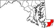
U.S. Highways Categories:- State highways in Maryland
- Roads in Worcester County, Maryland


Wikimedia Foundation. 2010.