- Cunningham Falls State Park
-
Cunningham Falls State Park IUCN Category V (Protected Landscape/Seascape)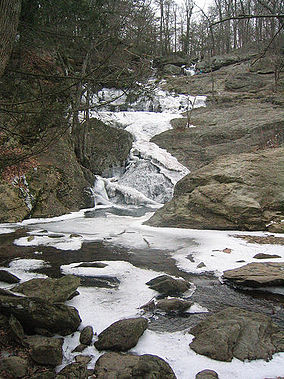
Location Frederick County, Maryland, USA Coordinates 39°35′57″N 77°27′03″W / 39.59917°N 77.45083°WCoordinates: 39°35′57″N 77°27′03″W / 39.59917°N 77.45083°W Governing body Maryland Department of Natural Resources Cunningham Falls State Park is a Maryland State Park located west of Thurmont, Maryland, USA, in the Catoctin Mountains. It features a 43-acre (170,000 m2) man-made lake and its namesake waterfall, Cunningham Falls. Cunningham Falls is a 78-foot (24 m) cascading waterfall. It is the largest (cascading) waterfall in Maryland.[1] Catoctin Mountain Park borders the state park to the north. Common recreational activities include hiking, hunting, swimming, boating, fishing, and camping. Big Hunting Creek flows through the park. It is one of Marylands' premier trout streams.[citation needed]
Catoctin Furnace, the remains of a historic iron furnace, can be toured in the park.
History
The area around Cunningham Falls is rich in local history. Before the arrival of Europeans many Native Americans farmed, hunted and fished the area. The area was also quarried by Native Americans for metarhyolite to make projectile points.[citation needed] Around the 1800s, settlers began to cut down the forests around the area to make charcoal to power the Catoctin Iron Furnace. The charcoal flats can still be seen as you hike through the park. The "charcoal flats" are approximately 25 feet (7.6 m) by 25 feet (7.6 m) square areas cut flat into the hillsides and linked by mule trails. They were used to build charcoal kilns. Too many years of clear cutting and abuse of the forest led to the destruction of the land.
In the 1930s, after years of making charcoal to fuel nearby iron furnaces, mountain farming, and harvesting of trees for timber, land was purchased by the Federal Government to be transformed into a productive recreation area; helping to put people back to work during the Great Depression. Beginning in 1935, the Catoctin Recreational Demonstration Area was under construction by both the Works Progress Administration and the Civilian Conservation Corps. The northern portion of the park was transferred to the National Park Service on November 14, 1936, and renamed and reorganized on July 12, 1954 with the southern 5,000 acres (20 km2) transferred to Maryland as Cunningham Falls State Park.[2]
West of the Falls on Big Hunting Creek lies "Dunkards Trough".[citation needed] It is a natural rock formation in the stream that forms a deep trough. It was used by an early religious group (the Dunkards)for baptisms.[citation needed]
Cunningham Falls was apparently named after a photographer from Pen Mar Park who photographed people at the Falls.[citation needed] The area was originally settled by the McAfee family.[citation needed] An old homestead can be seen above the Falls.
There is an abandoned gold or possibly copper mine located in the Park.
References
- ^ http://www.dnr.state.md.us/publiclands/western/cunningham.asp
- ^ Strain, Paula. The Blue Hills on Maryland. The Potomac Appalachian Trail Club, 1993. pp. 257-260.
External links
Protected Areas of Maryland Federal Blackwater • Eastern Neck • Martin • Patuxent Research Refuge • Susquehanna RiverState Assateague • Big Run • Bill Burton Fishing Pier State Park • Calvert Cliffs • Casselman River Bridge • Chapel Point • Cunningham Falls • Dans Mountain • Deep Creek Lake • Elk Neck • Fort Frederick • Fort Tonoloway • Gambrill • Gathland • Greenbrier • Greenwell • Gunpowder Falls • Hart-Miller Island • Herrington Manor • Janes Island • Jonas Green • Martinak • Matapeake • New Germany • North Point • Palmer • Patapsco Valley • Patuxent River • Pocomoke River • Point Lookout • Purse • Rocks • Rocky Gap • Rosaryville • Sandy Point • Seneca Creek • Smallwood • South Mountain • St. Clement's Island • St. Mary's River • Susquehanna • Swallow Falls • Tuckahoe • Washington Monument • Wye Oak
Cedarville • Chesapeake • Doncaster • Elk Neck • Garrett • Green Ridge • Pocomoke • Potomac-Garrett • Savage River • Seth • Stoney • Wicomico
Avondale • Belle Grove • Billmeyer • Bowen • Cedar Island • Cedar Point • Cheltenham • Chicamuxen • Dan's Mountain • Deal Island • Diersson • E.A. Vaughn • Earlville • Ellis Bay • Fairmount • Fishing Bay • Frederick City Watershed • Grove Farm • Gwynnbrook • Heater's Island • Hugg-Thomas • Idylwild • Indian Springs • Islands of the Potomac • Isle of Wight • Johnson • Le Compte • Linkwood • McKee-Beshers • Maryland Marine Properties • Millington • Mt. Nebo • Myrtle Grove • Nanticoke River • Old Bohemia • Pocomoke River • Prather’s Neck • Pocomoke Sound • Sideling Hill • Sinepuxent Bay • South Marsh • Strider • Taylors Island • Warrior Mountain • Wellington
Belt Woods • Dundee • Governor Parris N. Glendening • Mattawoman • Morgan Run • Severn Run • Soldiers Delight • Zekiah Swamp
County and
MunicipalParks & SanctuariesAcorn Park • Clifton Park • Constitution Park • Fort Smallwood Park • Jug Bay Wetlands Sanctuary • Lake Centennial • Lake Elkhorn • Lakelands Park • Oregon Ridge Park • Patterson Park • Robert E. Lee Memorial ParkNon-governmental Parks & SanctuariesBattle Creek Cypress Swamp Sanctuary • Merkle Wildlife Sanctuary • Sherwood Gardens • Somers Cove Marina • Sugarloaf Mountain • Western Maryland Rail Trail • Youghiogheny Scenic & Wild River
Maryland Department of Natural Resources (web): Maryland Park Service (web) and Maryland Forest ServiceCategories:- IUCN Category V
- Parks in Frederick County, Maryland
- Maryland state parks
- Civilian Conservation Corps in Maryland
- Works Progress Administration in Maryland
- Protected areas established in 1954
- Maryland geography stubs

Wikimedia Foundation. 2010.