- Dümpelfeld
-
Dümpelfeld 
 DümpelfeldLocation of Dümpelfeld within Ahrweiler district
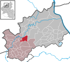

Coordinates 50°26′33″N 6°55′59″E / 50.4425°N 6.93306°ECoordinates: 50°26′33″N 6°55′59″E / 50.4425°N 6.93306°E Administration Country Germany State Rhineland-Palatinate District Ahrweiler Municipal assoc. Adenau Local subdivisions 2 Mayor Udo Stratmann Basic statistics Area 11.86 km2 (4.58 sq mi) Elevation 481 m (1578 ft) Population 637 (31 December 2010)[1] - Density 54 /km2 (139 /sq mi) Other information Time zone CET/CEST (UTC+1/+2) Licence plate AW Postal code 53520 Area code 02691 Website http://www.duempelfeld-ahr.de/ Dümpelfeld is a municipality in the district of Ahrweiler, in Rhineland-Palatinate, Germany.
Adenau · Ahrbrück · Altenahr · Antweiler · Aremberg · Bad Breisig · Bad Neuenahr-Ahrweiler · Barweiler · Bauler · Berg · Brenk · Brohl-Lützing · Burgbrohl · Dankerath · Dedenbach · Dernau · Dorsel · Dümpelfeld · Eichenbach · Fuchshofen · Galenberg · Glees · Gönnersdorf · Grafschaft · Harscheid · Heckenbach · Herschbroich · Hoffeld · Hohenleimbach · Honerath · Hönningen · Hümmel · Insul · Kalenborn · Kaltenborn · Kempenich · Kesseling · Kirchsahr · Königsfeld · Kottenborn · Leimbach · Lind · Mayschoß · Meuspath · Müllenbach · Müsch · Niederdürenbach · Niederzissen · Nürburg · Oberdürenbach · Oberzissen · Ohlenhard · Pomster · Quiddelbach · Rech · Reifferscheid · Remagen · Rodder · Schalkenbach · Schuld · Senscheid · Sierscheid · Sinzig · Spessart · Trierscheid · Waldorf · Wassenach · Wehr · Weibern · Wershofen · Wiesemscheid · Wimbach · Winnerath · Wirft

References
- ^ "Bevölkerung der Gemeinden am 31.12.2010" (in German). Statistisches Landesamt Rheinland-Pfalz. 31 December 2010. http://www.statistik.rlp.de/fileadmin/dokumente/berichte/A1033_201022_hj_G.pdf.
Categories:- Municipalities in Rhineland-Palatinate
- Ahrweiler geography stubs


Wikimedia Foundation. 2010.