- Watertable control
-
Watertable control is the practice of controlling the water table in agricultural land by subsurface drainage with proper criteria to improve the crop production.
Contents
Description and definitions
Subsurface land drainage [1] aims at controlling the water table of the groundwater in originally waterlogged land at a depth acceptable for the purpose for which the land is used. The depth of the water table with drainage is greater than without.
 Figure 1. Drainage parameters in watertable control
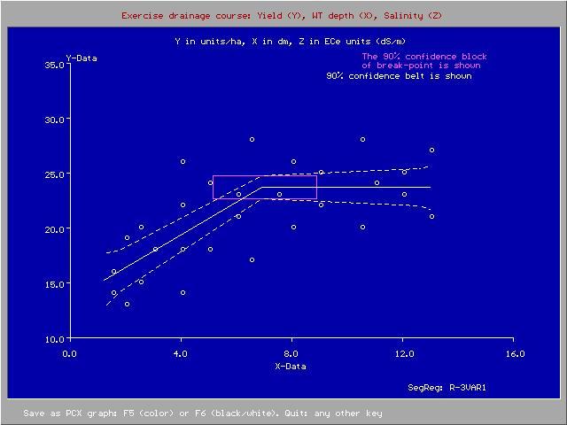
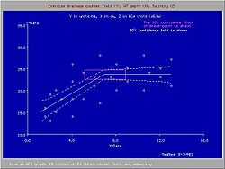 Figure 2. Crop yield (Y) and depth of water table (X in dm)
Purpose
In agricultural land drainage, the purpose of water table control is to establish a depth of the water table (Figure 1) that does no longer interfere negatively with the necessary farm operations and crop yields (Figure 2, made with the SegReg model, see the page: segmented regression).
In addition, land drainage can help with soil salinity control.
The soil's hydraulic conductivity plays an important role in drainage design.The development of agricultural drainage criteria [2] is required to give the designer and manager of the drainage system a target to achieve in terms of maintenance of an optimum depth of the water table.
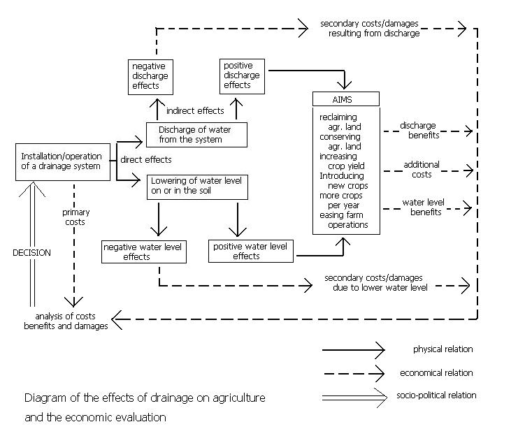
 Figure 3. Positive and negative effects of land drainage
Optimization
Optimization of the depth of the water table is related the benefits and costs of the drainage system (Figure 3). The shallower the permissible depth of the water table, the lower the cost of the drainage system to be installed to achieve this depth. However, the lowering of the originally too shallow depth by land drainage entails side effects. These have also to be taken into account, including the costs of mitigation of negative side effects.[2]
 Figure 4. Example of effects of drain depth
The optimization of drainage design and the development of drainage criteria are discussed in the article on drainage research.
Figure 4 shows an example of the effect of drain depth on soil salinity and various irrigation/drainage parameters as simulated by the SaltMod program.[3]
History
Historically, agricultural land drainage started with the digging of relatively shallow open ditches that that received both runoff from the land surface and outflow of groundwater. Hence the ditches had a surface as well as a subsurface drainage function.
By the end of the 19th century and early in the 20th century it was felt that the ditches were a hindrance for the farm operations and the ditches were replaced by buried lines of clay pipes (tiles), each tile about 30 cm long. Hence the term "tile drainage".
Since 1960, one started using long, flexible, corrugated plastic (PVC or PE) pipes that could be installed efficiently in one go by trenching machines. The pipes could be pre-wrapped with an envelope material, like synthetic fibre and geotextile, that would prevent the entry of soil particles into the drains.
Thus, land drainage became a powerful industry. At the same time agriculture was steering towards maximum productivity, so that the installation of drainage systems came in full swing.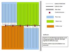 Figure 5. Controlled drainage
Environment
As a result of large scale developments, many modern drainage projects were over-designed,[4] while the negative environmental side effects were ignored. In circles with environmental concern, the profession of land drainage got a poor reputation, sometimes justly so, sometimes unjustified, notably when land drainage was confused with the more encompassing activity of wetland reclamation. Nowadays, in some countries, the hardliner trend is reversed. Further, checked or controlled drainage systems were introduced, as shown in Figure 5 and discussed on the page: Drainage system (agriculture).
Drainage design
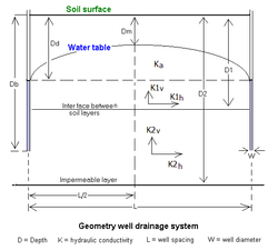 Figure 6. Geometry of a well drainage system
The design of subsurface drainage systems in terms layout, depth and spacing of the drains is often done using subsurface drainage equations with parameters like drain depth, depth of the water table, soil depth, hydraulic conductivity of the soil and drain discharge. The drain discharge is found from an agricultural water balance.
The computations can be done using computer models like EnDrain.[5]Drainage by wells
Subsurface drainage of groundwater can also be accomplished by pumped wells (vertical drainage, in contrast to horizontal drainage). Drainage wells have been used extensively in the Salinity Control and Reclamation Program (SCARP) in the Indus valley of Pakistan. Although the experiences were not overly successful, the feasibility of this technique in areas with deep and permeable aquifers is not to be discarded. The well spacings in these areas can be so wide (more than 1000m) that the installation of vertical drainage systems could be relatively cheap compared to horizontal subsurface drainage (drainage by pipes, ditches, trenches, at a spacing of 100m or less). For the design of a well field for control of the water table, the WellDrain model [6] may be helpful.
Classification
A classification of drainage systems is found in the article Drainage system (agriculture).
See also
- Subsurface dyke
References
- ^ Nosenko, P.P. and I.S. Zonn 1976. Land Drainage in the World. ICID Bulletin 25, 1, pp.65-70.
- ^ a b Agricultural Drainage Criteria, Chapter 17 in: H.P.Ritzema (2006), Drainage Principles and Applications, Publication 16, International Institute for Land Reclamation and Improvement (ILRI), Wageningen, The Netherlands. ISBN 90 70754 3 39. Download from : [1] or directly as PDF : [2]
- ^ SaltMod, Description of Principles, User Manual, and Examples of Application. ILRI Special Report. International Institute for Land Reclamation and Improvement (ILRI), Wageningen, The Netherlands. Download from : [3] or directly as PDF: [4]
- ^ Agricultural Land Drainage: a wider application through caution and restraint. In: ILRI Annual Report 1991, pp. 21-36, International Institute for Land Reclamation and Improvement (ILRI), Wageningen, The Netherlands. Download from : [5] or directly as PDF : [6]
- ^ The energy balance of groundwater flow applied to subsurface drainage in anisotropic soils by pipes or ditches with entrance resistance, International Institute for Land Reclamation and Improvement (ILRI), Wageningen, The Netherlands. Download from: [7] or directly as PDF : [8]
Paper based on: R.J. Oosterbaan, J. Boonstra and K.V.G.K. Rao, 1996, The energy balance of groundwater flow. Published in V.P.Singh and B.Kumar (eds.), Subsurface-Water Hydrology, p. 153-160, Vol.2 of Proceedings of the International Conference on Hydrology and Water Resources, New Delhi, India, 1993. Kluwer Academic Publishers, Dordrecht, The Netherlands. ISBN 978-0-7923-3651-8. Download as PDF : [9]
Download the EnDrain program from : [10] - ^ Subsurface drainage by (tube)wells: well spacing equations for fully and partially penetrating wells in uniform or layered aquifers with or without anisotropy and entrance resistance. Paper explaining the basics of the WellDrain model, International Institute for Land Reclamation and Improvement (ILRI), Wageningen, The Netherlands. Download as PDF : [11]
Download the WellDrain program from : [12]
External links
- American Wick Drain- Manufacturer of strip drain used in watertable management
- Chapters of ILRI publication 16 on "Drainage Principles and Applications" can be viewed in: http://www.alterra.wur.nl/NL/publicaties+Alterra/ILRI-publicaties/Downloadable+publications/
- Website on Waterlogging and Land Drainage : [13]
- Various articles on Waterlogging and Land Drainage can be freely downloaded from : [14]
- For answers to frequently asked questions on Waterlogging and Land Drainage see : [15]
- Reports and case studies on Waterlogging and Land Drainage can be consulted at : [16]
- Software on Waterlogging and Land Drainage can be freely downloaded from : [17]
- A model of subsurface groundwater drainage for water table and soil salinity control (SaltMod) can be freely downloaded from : [18]
- The combination of SaltMod with a polygonal model of groundwater flow (SahysMod) can be freely downloaded from : [19]
Agricultural water management Irrigation Surface irrigation · Tidal irrigation · Irrigation of alluvial fans · Irrigation statistics · Irrigation management · Irrigation environmental impactsSubsurface drainage Tile drainage · Drainage equation · Drainage system (agriculture) · Watertable control · Drainage research · Drainage by wellsSurface water/runoff Groundwater Groundwater flow · Groundwater energy balance · Groundwater model · Hydraulic conductivity · WatertableProblem soils Agro-hydro-salinity group Hydrology (agriculture) · Soil salinity control · Leaching model (soil) · SaltMod integrated model · SahysMod polygonal model: Saltmod coupled to a groundwater modelRelated topics Sand dam ·Categories:- Drainage
- Aquifers
- Land management
- Land reclamation
- Water management
- Hydraulic engineering
- Water and the environment


Wikimedia Foundation. 2010.