- Newton, Greater Manchester
-
Coordinates: 53°27′36″N 2°05′24″W / 53.4600°N 2.090°W
Newton 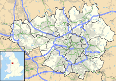
 Newton
Newton shown within Greater ManchesterPopulation 12,000 (2001) Metropolitan borough Tameside Metropolitan county Greater Manchester Region North West Country England Sovereign state United Kingdom Post town HYDE Postcode district SK14 Dialling code 0161 Police Greater Manchester Fire Greater Manchester Ambulance North West EU Parliament North West England UK Parliament Stalybridge and Hyde List of places: UK • England • Greater Manchester Newton is an area of Hyde, in Tameside, Greater Manchester, England. Originally a separate district in Cheshire, it was incorporated into Hyde in the 1930s, and occupies a narrow strip of land from the River Tame near Newton Hall to Matley, and lies between Hyde and Dukinfield.
Newton can be divided into four separate parts, working uphill from the river:
- Newton Green
- Flowery Field
- Newton Moor
- Newton
Categories:- Geography of Tameside
- Villages in Greater Manchester
- Greater Manchester geography stubs

Wikimedia Foundation. 2010.