- Cobb Point Bar Light
-
Cobb Point Bar Light 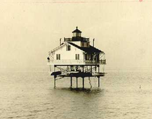
1912 photograph of Cobb Point Bar Light (USCG) Location off Cobb Island in the Potomac River at the mouth of the Wicomico River Coordinates 38°14′33″N 76°49′36″W / 38.2424°N 76.8266°WCoordinates: 38°14′33″N 76°49′36″W / 38.2424°N 76.8266°W Year first lit 1889 Deactivated 1940 Foundation screw-pile Construction cast-iron/wood Tower shape hexagonal house Original lens fourth-order Fresnel lens The Cobb Point Bar Light (also called Cobb Island Bar Light) was a screw-pile lighthouse located in the Potomac River.
History
A light at Cobb Point was first requested in 1875 to mark the entrance to the tricky channel leading into the Wicomico River (not to be confused with the river of the same name on the Eastern Shore). After two additional requests, funds were finally appropriated in 1887. Construction was delayed, however, and the light was not commissioned until Christmas 1889.
A fire in 1939 caused by light keeper Matthew Wicke, resulted in heavy damage, and in the following year the house was torn down, replaced by a beacon set on the same foundation.
References
- "Historic Light Station Information and Photography: Maryland". United States Coast Guard Historian's Office. http://www.uscg.mil/history/weblighthouses/LHMD.asp.
- Cobb Point Bar Light, from the Chesapeake Chapter of the United States Lighthouse Society
- de Gast, Robert (1973). The Lighthouses of the Chesapeake. Johns Hopkins University Press. p. 158.
External links
- Rowlett, Russ. "Lighthouses of the United States: Maryland". The Lighthouse Directory. University of North Carolina at Chapel Hill. http://www.unc.edu/~rowlett/lighthouse/md.htm.
 Categories:
- Lighthouses in Maryland
- Buildings and structures completed in 1889


Wikimedia Foundation. 2010.