- Ozark, Alabama
-
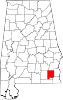
Ozark, Alabama — City — Location in Dale County and the state of Alabama
Coordinates: 31°26′53″N 85°38′31″W / 31.44806°N 85.64194°W Country United States State Alabama County Dale Settled Incorporated October 27, 1870 Government - Type Mayor/City Council - Mayor Billy Blackwell Area - Total 34.4 sq mi (89.3 km2) - Land 34.2 sq mi (88.7 km2) - Water 0.2 sq mi (0.6 km2) Elevation 417 ft (127 m) Population (2000) - Total 15,119 - Density 439.5/sq mi (169.3/km2) Time zone Central (CST) (UTC-6) - Summer (DST) CDT (UTC-5) ZIP codes 36360-36361 Area code(s) 334 FIPS code 01-57648 GNIS feature ID 0152832 Website http://www.ozarkalabama.us/ Ozark is a city in and the county seat of Dale County, Alabama, United States.[1] In 1990 the city population was 12,922.[2] As of the 2000 census, the population of the city was 15,119.[3]
Ozark along with the city of Enterprise, are principal cities of the Enterprise–Ozark Micropolitan Statistical Area, which includes all of Dale and Coffee counties. Fort Rucker, the primary flight training base for Army Aviation, abuts Ozark.
Contents
History
The Ozark area was originally inhabited by the Creek Indians. It is said that Ozark received its name after a traveller thought it reminded him of the Ozark Mountains in Arkansas.
The first known European settler in Ozark was John Merrick Sr., a veteran of the Revolutionary War, in 1822. In honor of him, the town was named Merricks. It was later changed to Woodshop, which was its name when the town received its post office. The first appearance of the name Ozark was in 1855, when the citizens requested a name change.[4]
The county seat was moved from Newtown to Ozark 1870.[4][5]
Geography
Ozark is located at 31°26′53″N 85°38′31″W / 31.44806°N 85.64194°W (31.448169, -85.642009)[6]. It is part of the Wiregrass Region.
According to the U.S. Census Bureau, the city has a total area of 34.5 square miles (89 km2) of which 34.2 square miles (89 km2) is land and 0.2 square miles (0.52 km2) (0.70%) is water.[7]
Demographics
As of the census[8] of 2000, there were 15,119 people, 6,126 households, and 4,233 families residing in the city.[3] The population density was 441.5 inhabitants per square mile (170.5 /km2). There were 6,955 housing units at an average density of 203.1 per square mile (78.4 /km2).[7] The racial makeup of the city was 68.28% White, 28.30% Black or African American, 0.67% Native American, 0.70% Asian, 0.05% Pacific Islander, 0.46% from other races, and 1.53% from two or more races. 2.08% of the population were Hispanic or Latino of any race.[3]
There were 6,126 households out of which 31.4% had children under the age of 18 living with them, 48.8% were married couples living together, 16.9% had a female householder with no husband present, and 30.9% were non-families. 27.7% of all households were made up of individuals and 10.6% had someone living alone who was 65 years of age or older. The average household size was 2.40 and the average family size was 2.92.[3]
In the city the population was spread out with 24.9% under the age of 18, 8.5% from 18 to 24, 26.0% from 25 to 44, 24.7% from 45 to 64, and 15.9% who were 65 years of age or older. The median age was 39 years. For every 100 females there were 87.8 males. For every 100 females age 18 and over, there were 83.4 males.[3]
The median income for a household in the city was $29,330, and the median income for a family was $38,633. Males had a median income of $30,236 versus $19,564 for females. The per capita income for the city was $15,984. About 14.8% of families and 19.0% of the population were below the poverty line, including 27.0% of those under age 18 and 18.0% of those age 65 or over.[3]
Education
Ozark is served by the Ozark City Schools. Schools located in the city are Carroll High School (grades 9 through 12), Carroll Career Center (grades 9 through 12), D.A. Smith Middle School (grades 6 through 8), Harry M. Mixon Elementary School (grades 1 through 5), Joseph W. Lisenby Elementary School (grades 1 through 5) and Mamie Thompkins School (Kindergarten).
There are three private schools in Ozark - Harvest Christian School, Dale County Christian School, and Eastgate Christian Academy (all grades K through 12).
Post-secondary education is available at Enterprise State Community College's Alabama Aviation Center at Ozark. Programs are offered in in Aviation maintenance technology.
-

Carroll High School Band 2009
-

Carroll High School Marching Band "Pride of the Wiregrass" 2007
Media
Radio Stations
- WAQG 91.7 FM (Contemporary Christian)
- WJRL 103.9 FM (Sports talk)
- WOAB 104.9 FM (Adult standards
- WOZK 900 AM (MOR)
- WQLS 1210 AM (Gospel)
Newspaper
- The Southern Star- weekly
Notable residents
- Wilbur Jackson – National Football League
- Byron Mitchell - former super middleweight boxing champion.
- Steve McLendon - Nose Tackle/Defensive End, Pittsburgh Steelers
See also
References
- ^ "Find a County". National Association of Counties. http://www.naco.org/Counties/Pages/FindACounty.aspx. Retrieved 2011-06-07.
- ^ "Fast Facts- 1990 Data Set Ozark city, Alabama". DP-1. General Population and Housing Characteristics:. United States Census Bureau. http://factfinder.census.gov/servlet/QTTable?_bm=y&-context=qt&-qr_name=DEC_1990_STF1_DP1&-ds_name=DEC_1990_STF1_&-CONTEXT=qt&-tree_id=100&-redoLog=true&-all_geo_types=N&-geo_id=label&-geo_id=16000US011330&-search_results=16000US011330&-format=&-_lang=en. Retrieved 29 January 2010.
- ^ a b c d e f "Fact Sheet- Ozark city, Alabama". American Fast Facts. United States Census Bureau. http://factfinder.census.gov/servlet/SAFFFacts?_event=Search&geo_id=&_geoContext=&_street=&_county=ozark&_cityTown=ozark&_state=04000US01&_zip=&_lang=en&_sse=on&pctxt=fph&pgsl=010&show_2003_tab=&redirect=Y. Retrieved 29 January 2010.
- ^ a b Watson, Fred Shelton (1968). Forgotten trails: a history of Dale County, Alabama, 1824-1966. Birmingham, Alabama: Banner Press. pp. 288.
- ^ Hoskins Morton, Patricia (10 December 2010). "Dale County". Encyclopedia of Alabama. http://www.encyclopediaofalabama.org/face/Article.jsp?id=h-1327. Retrieved 1 February 2010.
- ^ "US Gazetteer files: 2010, 2000, and 1990". United States Census Bureau. 2011-02-12. http://www.census.gov/geo/www/gazetteer/gazette.html. Retrieved 2011-04-23.
- ^ a b "Geographic Comparison Table- Alabama". American Fast Facts. United States Census Bureau. http://factfinder.census.gov/servlet/GCTTable?_bm=y&-geo_id=04000US01&-_box_head_nbr=GCT-PH1&-ds_name=DEC_2000_SF1_U&-format=ST-7. Retrieved 29 January 2010.
- ^ "American FactFinder". United States Census Bureau. http://factfinder.census.gov. Retrieved 2008-01-31.
External links
Coordinates: 31°26′53″N 85°38′31″W / 31.448169°N 85.642009°W
Municipalities and communities of Dale County, Alabama County seat: Ozark Cities Daleville | Dothan‡ | Enterprise‡ | Ozark
Towns Ariton | Clayhatchee | Grimes | Level Plains | Midland City | Napier Field | Newton | Pinckard
CDPs Footnotes ‡This populated place also has portions in an adjacent county or counties
Categories:- Populated places established in 1822
- Cities in Alabama
- Populated places in Dale County, Alabama
- Enterprise-Ozark micropolitan area
- County seats in Alabama
-


Wikimedia Foundation. 2010.