- Moulton, Alabama
-
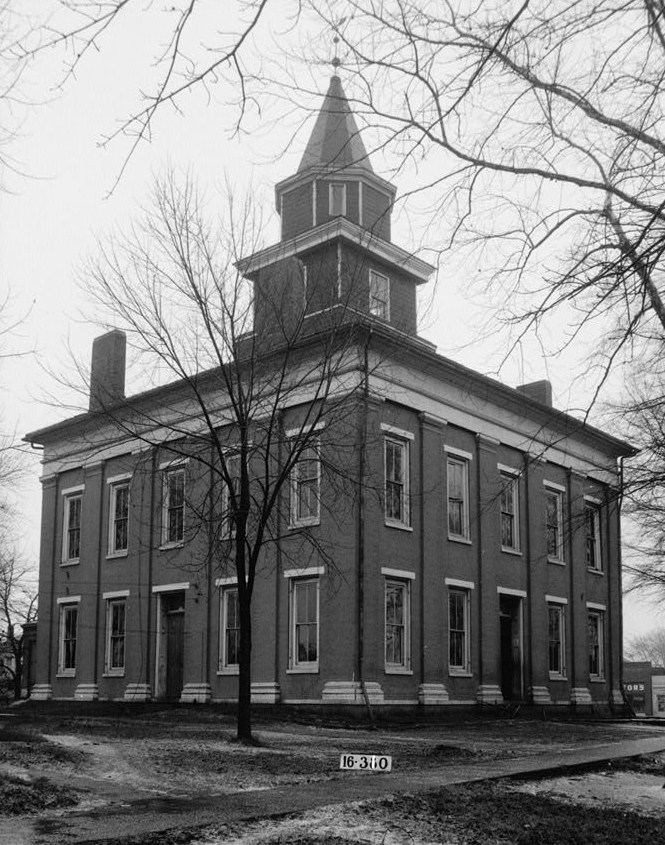
Moulton — City — Lawrence County Courthouse in Moulton, March 1934 Location in Lawrence County and the state of Alabama
Coordinates: 34°28′56″N 87°17′8″W / 34.48222°N 87.28556°W Country United States State Alabama County Lawrence Area – Total 5.9 sq mi (15.3 km2) – Land 5.9 sq mi (15.3 km2) – Water 0 sq mi (0 km2) Elevation 640 ft (195 m) Population (2000) – Total 3,260 – Density 552.5/sq mi (213.1/km2) Time zone Central (CST) (UTC-6) – Summer (DST) CDT (UTC-5) ZIP code 35650 Area code(s) 256 FIPS code 01-51600 GNIS feature ID 0160141 Moulton is a city in Lawrence County, Alabama, and is included in the Decatur Metropolitan Area, as well as the Huntsville-Decatur Combined Statistical Area. As of the 2000 census, the population of the city is 3,260. The city is the county seat of Lawrence County.
Contents
Geography
Moulton is located at 34°28′56″N 87°17′8″W / 34.48222°N 87.28556°W (34.482307, -87.285621)[1].
According to the U.S. Census Bureau, the city has a total area of 5.9 square miles (15 km2), all of it land.
Demographics
As of the census[2] of 2000, there were 3,260 people, 1,384 households, and 863 families residing in the city. The population density was 552.1 people per square mile (213.3/km²). There were 1,486 housing units at an average density of 251.7 per square mile (97.2/km²). The racial makeup of the city was 79.82% White, 15.00% Black or African American, 2.76% Native American, 0.34% Asian, 0.09% from other races, and 1.99% from two or more races. 0.83% of the population were Hispanic or Latino of any race.
There were 1,384 households out of which 24.7% had children under the age of 18 living with them, 46.0% were married couples living together, 13.4% had a female householder with no husband present, and 37.6% were non-families. 36.1% of all households were made up of individuals and 18.1% had someone living alone who was 65 years of age or older. The average household size was 2.19 and the average family size was 2.84.
In the city the population was spread out with 20.7% under the age of 18, 7.6% from 18 to 24, 26.7% from 25 to 44, 23.1% from 45 to 64, and 21.8% who were 65 years of age or older. The median age was 41 years. For every 100 females there were 81.7 males. For every 100 females age 18 and over, there were 77.2 males.
The median income for a household in the city was $26,591, and the median income for a family was $35,195. Males had a median income of $30,964 versus $27,339 for females. The per capita income for the city was $15,638. About 12.6% of families and 17.6% of the population were below the poverty line, including 18.8% of those under age 18 and 31.4% of those age 65 or over.
Media
Moulton is home to one radio station, WALW-LP (98.3 FM).
References
- ^ "US Gazetteer files: 2010, 2000, and 1990". United States Census Bureau. 2011-02-12. http://www.census.gov/geo/www/gazetteer/gazette.html. Retrieved 2011-04-23.
- ^ "American FactFinder". United States Census Bureau. http://factfinder.census.gov. Retrieved 2008-01-31.
Coordinates: 34°28′56″N 87°17′08″W / 34.482307°N 87.285621°W
Communities of the Huntsville-Decatur Area Population over 100,000 Population over 50,000 Population over 20,000 Population over 10,000 Population over 5,000 Population over 2,000 Population over 1,000 Population over 500 Population over 200 Population under 200 Unincorporated areas Belle Mina · Caddo · Danville · Hulaco · Lacey's Spring · Meridianville · Morgan City · Moulton Heights · New Market · Tanner · ToneyCounties Municipalities and communities of Lawrence County, Alabama County seat: MoultonCity Moulton

Towns Unincorporated
communitiesCategories:- Cities in Alabama
- Populated places in Lawrence County, Alabama
- Decatur Metropolitan Area
- Huntsville–Decatur Combined Statistical Area
- County seats in Alabama


Wikimedia Foundation. 2010.