- Nevada State Route 430
-
State Route 430
Carson-Reno Highway, Virginia Street Route information Maintained by NDOT Length: 15.690 mi[1] (25.251 km) Existed: 1976 – present Section 1 Length: 13.207 mi[1] (21.255 km) South end: 
 US 395 / SR 429 near Washoe City
Major
junctions: US 395North end: Patriot Blvd Section 2 Length: 2.483 mi[1] (3.996 km) South end:  SR 659
North end: US 395 north of RenoHighway system ← SR 429SR 431  →
→State Route 430 is a major north–south state highway in Washoe County, Nevada which currently exists as two separate sections. South of Reno, the route follows the Carson-Reno Highway, and currently overlaps U.S. Route 395. In Reno, the highway follows Virginia Street, the primary north–south arterial street of the city. SR 430, as well as the gap between the two segments, is also designated as U.S. Route 395 Business within Reno city limits, although the business route is mostly unsigned.
Contents
Route description
Carson-Reno Highway
State Route 430 begins near Winters Ranch just south of the small town of Washoe City at its junction with U.S. Route 395 and Bowers Mansion Road (State Route 429). At this point, the route is concurrent with US 395 as it makes it way towards Reno.
From its southern terminus, the route curves northeast through Washoe City. As the highway exits the town, it briefly climbs southeast of Washoe Hill to ascends Washoe Summit (elevation 5,089 feet (1,551 m)). The junction with Eastlake Boulevard (former SR 428) at the top of this hill is dubbed the "Washoe Hill Memorial", and is dedicated to victims of drunk driving. As the road descends, it curves north once again to enter Pleasant Valley. The route crosses over Steamboat Creek and Jones Creek as it passes through the rural community.
 Overlooking SR 430/US 395 as it passes through Steamboat Hills.
After leaving Pleasant Valley, SR 430 curves east and north again to travel through Steamboat Hills. Development of this small community dates back to 1859, when a small resort was established that took advantage of the natural hot springs nearby.[2] Steamboat's springs are still active today, producing geothermal power for northwest Nevada since 1991.[3]
The highway meets the Mount Rose Junction just north of Steamboat. This junction provides access to Mount Rose and North Lake Tahoe via Mount Rose Highway (State Route 431), as well as Virginia City to the southeast by Geiger Grade (State Route 341). After passing the junction, the route enters the Reno city limits. US 395 departs from SR 430 shortly thereafter, following the North–South Freeway into Reno.
Virginia Street
As State Route 430 passes under the freeway, it changes to Virginia Street and the U.S. Route 395 Business designation begins. The roadway turns slightly more westward as it travels further north into Reno. In about three miles (5 km), the highway again meets the US 395 freeway. The southern section of State Route 430 reaches its northern terminus just north of here, at the intersection with Patriot Boulevard; Business US 395, however continues to follow Virginia Street northward.
Beyond SR 430's terminus, businesses appear more frequently along the arterial. Large retail stores, shopping malls and restaurants begin to line the sides of the business route. After passing another interchange with US 395 (also unsigned Interstate 580 by this point) and the junction with Kietzke Lane, the Reno-Sparks Convention Center can be seen along the east side of the road, along with larger casino properties and additional businesses as the route continues north. Passing north of California Avenue, Virginia Street narrows down and reaches Downtown Reno. Seen amongst other businesses along the highway are major office buildings, government institutions, and cultural centers.
In the center of Reno, Business US 395 crosses over the Truckee River on the Virginia Street Bridge. The river crossing dates back to 1860, prior to the Reno's existence as "Lake's Crossing".[4] The current structure, built in 1905 as the fifth bridge at this location, is the oldest bridge in Reno and was one of the first reinforced concrete bridges built in Nevada. Designed by John B. Leonard, the structure includes etchings to resemble masonry.[5] Since 1992, the bridge structure has been declared structurally deficient due to its impedance of high water flows on the Truckee. Balancing the structure's historic status with the required flood water flow conveyance has stalled rehabilitation or replacement of the structure.[6]
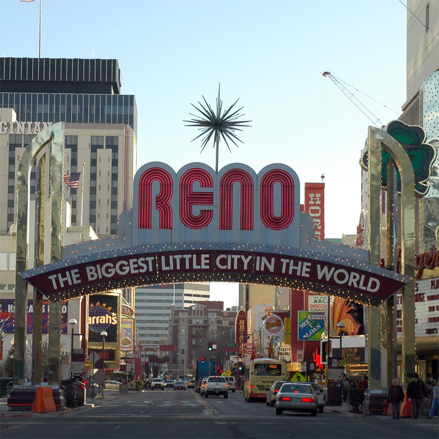
 Looking south in 2007, Virginia Street passes under the famous Reno Arch
On the opposite side of the river crossing, US 395 Business reaches enters downtown core. Each side of the highway is lined with numerous casinos and small businesses. Portions of Virginia Street between First Street and Sixth Street are frequently closed to vehicular traffic (most often in the summertime) to host special events that attract tourists and locals to the downtown area; such events include Hot August Nights, Street Vibrations, parades, and other activities. A notable landmark along this stretch of roadway is the Biggest Little City in the World sign. Located at Virginia and Commercial Row (just south of Third Street), the current version of this famous arch was erected in 1987.[7]
North of downtown, the route intersects Interstate 80 as it heads away from the casinos. Just past the Interstate, Business US 395 encounters the University of Nevada, Reno campus. Academic buildings, residence halls, the student union, Lawlor Events Center and Fleischmann Planetarium are university buildings visible from Virginia Street, which follows the western border of the campus.
State Route 430's northern segment begins as Virginia Street crosses North McCarran Boulevard (State Route 659). Roadside businesses taper off as the route travels north out of Reno, paralleling Union Pacific railroad tracks heading towards northern California. Both SR 430 and US 395 Business terminate at the route's final interchange with US 395 near Panther Valley north of Reno.
History
SR 430 is the original routing of US 395 through the Reno area. The US 395 designation was removed from Virginia Street and added to the new highway segmentally as new stretches of freeway were completed. SR 430 was designated as US 395 Business for some time after the freeway was completed. By 2001, any Business US 395 shields on Virginia Street had been removed; however, a few business shields remain on older overhead guide signs in the Reno area.
In 2001, the gap between the two segments of SR 430 along Virginia Street was much smaller. The southern section had a northern terminus at the intersection with Plumb Lane (SR 653). However, the state maintained part of South Virginia Street was truncated to the I-580 half interchange by 2006. More of SR 430 was given to local control by 2008, when the northern terminus of the southern section was moved to Patriot Boulevard. Also in 2001, the northern segment of SR 430 had a southern terminus at I-80. However, the portion of North Virginia Street along the west edge of the University of Nevada, Reno between I-80 and North McCarran Boulevard (SR 659) was relinquished to the City of Reno by January 2008.[1]
Major intersections
The major intersections table lists junctions for both State Route 430 and U.S. Route 395 Business. Both routes lie entirely within Washoe County.
- Note: As of December 2008, mileposts posted along State Route 430 indicate "US 395" while mileposts on sections of Business US 395 not concurrent with SR 430 show no route designation. The mileposts are continuous through both routes.
Location Mile Destinations Notes Washoe City SR 429 (Bowers Mansion Road, Old US 395)Begin SR 430 (Section 1); South end of US 395 overlap. 10.35 Eastlake Boulevard old SR 428 Reno  SR 341 (Geiger Grade) / SR 431 (Mount Rose Highway) – Virginia City, Lake Tahoe
17.00 US 395 north – RenoNorth end of US 395 overlap; Begin US 395 Business. South Meadows Parkway (SR 426) 19.80  SR 671 (Holcomb Ranch Lane)
20.10 US 395Patriot Boulevard End SR 430 (Section 1) 22.30 South McCarran Boulevard (SR 659 US 395 north (I-580)22.70  SR 667 (Kietzke Lane)
24.29 Plumb Lane  To Reno-Tahoe International Airport; Former SR 653
Virginia Street Bridge over the Truckee River  I-80 Bus. (Fourth Street)
Former US 40  I-80 – Elko, Sacramento
25.57 SR 659 (North McCarran Boulevard)Begin SR 430 (Section 2) North Virginia Street, Panther Drive Old US 395 US 395 – Reno, SusanvilleEnd SR 430 (Section 2). End US 395 Business References
- ^ a b c d Nevada Department of Transportation (January 2008). "Nevada State Maintained Highways: Descriptions, Index and Maps". http://www.nevadadot.com/reports_pubs/State_Maintained/. Retrieved 2009-01-08.
- ^ "Early History". The Healing Center & Spa at Steamboat Springs. International Community of Christ. 2006. http://www.steamboatsprings.org/historic_site/early_history/. Retrieved 2009-01-08.
- ^ "Steamboat Springs Geothermal Field". Online Nevada Encyclopedia. Nevada Bureau of Mines and Geology. 2007-02-05. http://www.onlinenevada.org/Steamboat_Springs_Geothermal_Field. Retrieved 2009-01-08.
- ^ "History of Virginia Street Bridge". City of Reno. 2008-07-29. http://www.reno.gov/Index.aspx?page=1572. Retrieved 2009-01-09.
- ^ "Virginia Street Bridge". Three Historic Nevada Cities: Carson City, Reno, Virginia City. National Park Service. http://www.nps.gov/history/nr/travel/nevada/vir.htm. Retrieved 2009-01-09.
- ^ "Background - Virginia Street Bridge". City of Reno. 2008-08-01. http://www.reno.gov/Index.aspx?page=1573. Retrieved 2009-01-09.
- ^ "Reno Arch History Downtown". New To Reno.com. http://www.newtoreno.com/renoarch.htm. Retrieved 2009-01-09.
Categories:- State highways in Nevada


Wikimedia Foundation. 2010.