- Craven Arms
-
Coordinates: 52°26′25″N 2°50′06″W / 52.4402°N 2.8349°W
Craven Arms 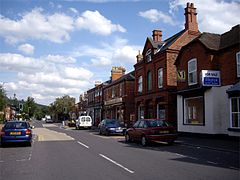
Corvedale Road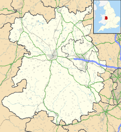
 Craven Arms
Craven Arms shown within ShropshirePopulation 2,289 OS grid reference SO432828 Parish Craven Arms Unitary authority Shropshire Ceremonial county Shropshire Region West Midlands Country England Sovereign state United Kingdom Post town CRAVEN ARMS Postcode district SY7 Dialling code 01588 Police West Mercia Fire Shropshire Ambulance West Midlands EU Parliament West Midlands UK Parliament Ludlow List of places: UK • England • Shropshire Craven Arms is a small town and civil parish in Shropshire, England, located on the A49 road and the Welsh Marches railway line, which connect it north and south to the larger towns of Shrewsbury and Ludlow respectively. The Heart of Wales railway line joins the Welsh Marches line at Craven Arms and the town has a small railway station. The town is enclosed to the north by the Shropshire Hills Area of Outstanding Natural Beauty, and to the south is the fortified manor house Stokesay Castle.
Craven Arms is a market town for the surrounding rural area, with a number of shops, banks, estate agents, a supermarket, an abattoir and many commercial/light industrial businesses. It is also a visitor destination, being home or nearby to a number of attractions, and being central for visitors to the area of outstanding natural beauty. It describes itself as the "Gateway to the Marches".
Contents
History
Craven Arms is a relatively new town (for Shropshire), being only a small village "Newton" on a map of 1695. The settlement grew when the railways came during the mid to late 19th century, making it a railway town. Newton or Newtown is still the name for the southeastern part of the present day town, while the northern part is called Newington or New Inn (another small village which existed prior to the town). The town takes its name from the Craven Arms Hotel, situated on the junction of the A49 and B4368 roads, which in turn is named after the Lords Craven (who owned nearby Stokesay Castle).
The civil parish of Craven Arms was formed from two older parishes — Stokesay and Halford. Small parts of the settlement overlap into neighbouring Wistanstow and Sibdon Carwood parishes.
Geography
Nearby towns are Bishop's Castle, Clun, Church Stretton and Ludlow, of which the last is the most substantial.
The River Onny flows to the town's east and just over the river is the small village of Halford. To the south is the small village of Stokesay, whilst to the north is the village of Wistanstow.
Wenlock Edge is to the northeast of the town and runs in a northeasterly direction, towards Much Wenlock.
Landmarks
 The entire town as viewed from the east.
Landmarks in the Craven Arms area include: the Shropshire Hills Discovery Centre, a centre featuring exhibits about the county's geography; and Stella Mitchell's Land of Lost Content Museum, a collection of 20th century memorabilia, which has recently opened. Stokesay Castle is a fortified manor house located near to Craven Arms.
Recent development
The town has recently gone through a phase of expansion and this looks set to continue with the (now abolished) South Shropshire District Council stating that they wished to see the town become the district's second main market town (after Ludlow) by 2026. Much of the recent housing development is on the west side of the town, whilst commercial development is taking place more on the northern end. Development potential towards the east is restricted by the floodplain of the River Onny, whilst to the south lies the historically important Stokesay Castle.
The town centre itself has seen some notable developments in recent years, with new commercial buildings built on Dale Street by the A49 road. Additionally, to the immediate south of the town centre is the new Secret Hills Discovery Centre and some new housing.
Cultural links
Bruce Chatwin wrote On the Black Hill whilst staying at Cwm Hall near the town.[1] The film Atonement was filmed in part near Stokesay.[2]
References
- ^ "Writer's retreat on the black hill". The Daily Telegraph (London). 12 June 2004. http://www.telegraph.co.uk/property/main.jhtml?xml=/property/2004/06/12/pwrit12.xml. Retrieved 30 April 2010.
- ^ Daily Telegraph (24 August 2007). "Joe Wright: a new movie master". The Daily Telegraph (London). http://www.telegraph.co.uk/arts/main.jhtml?xml=/arts/2007/08/24/bf-atonement-124.xml. Retrieved 24 August 2007.
Ceremonial county of Shropshire Boroughs or districts Major settlements Bishop's Castle • Bridgnorth • Broseley • Church Stretton • Cleobury Mortimer • Clun • Craven Arms • Ellesmere • Ludlow • Market Drayton • Much Wenlock • Newport • Oswestry • Shifnal • Shrewsbury • Telford (Dawley • Madeley • Oakengates • Wellington) • Wem • Whitchurch
See also: List of civil parishes in ShropshireRivers Topics Categories:- Market towns in Shropshire
- Towns of the Welsh Marches
- Railway towns in England
- Towns in Shropshire


Wikimedia Foundation. 2010.