- Drum Point Light
-
Drum Point Light 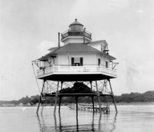
1915 photograph of Drum Point Light (USCG) Location originally off Drum Point at the mouth of the Patuxent River in the Chesapeake Bay; relocated to the Calvert Marine Museum Coordinates 38°19′08″N 76°25′16″W / 38.319°N 76.421°W (approximate original);
38°19′52″N 76°27′47″W / 38.331°N 76.463°W (current)Year first lit 1883 Automated 1960 Deactivated 1962 Foundation screw-pile Construction cast-iron/wood Tower shape hexagonal house Height 46 ft Original lens fourth-order Fresnel lens Range 12 mi Drum Point Light is one of three surviving Chesapeake Bay screw-pile lighthouses. Originally located off Drum Point at the mouth of the Patuxent River, it is now an exhibit at the Calvert Marine Museum.
Contents
History
The earliest recorded call for a light at Drum Point came in report by one Lt. William D. Porter to the Secretary of the Treasury. In the 1850s funds were appropriated and some initial surveys made; disputes between the state of Maryland and the federal government over the property to be used eventually brought these efforts to naught. If this project had been carried through, it would have been an early example of a screw-pile lighthouse in the bay, as the Pungoteague Creek Light had been finished only two years earlier. In spite of subsequent requests by steamship operators, it was not until 1882 that a $25,000 appropriation was made, and in the following year a 5-acre (20,000 m2) offshore lot was obtained. The original appropriation was to construct a pair of range lights, for reasons that remain obscure. The funds were not adequate for such a project and it was never seriously considered for execution. Instead, a screw-pile light was prefabricated in parts at Lazaretto Point, and the light was erected in about a month, being lit for the first time in August of that year.
The light was needed in the first place because of the considerable shoaling around the point. This gradually shifted the shoreline to the point where the light, which originally stood in ten feet of water, was entirely on land in 1970. At the turn of the century a small bridge was constructed from the light to the shore (as visible in the photograph), allowing the keeper's family to live with him in the light.
Unlike may such lights, Drum Point escaped ice damage. The storm of 1933 flooded the house and sank the tender, however.
Originally a fixed red light was shown, with dark sectors added starting in 1989. This was changed in 1911 to a fixed white light with red sectors. The light was converted to electricity in 1944 and automated in 1960. The light was discontinued two years later, replaced at first by a lighted buoy, and then a fixed offshore light. Unlike other such conversions, however, the house was not torn down, but simply abandoned. The Calvert County Historical Society attempted to acquire the light as early as 1966, but they did not gain possession until 1974, and the federal government retained the land on which it sat. However, due to a grant and the timely assistance of the B.F. Diamond Construction Company (which was constructing a bridge over the Patuxent nearby) the light was cut from the ground and barged to its current location. Restoration was aided by many grants and the donation of much period furnishings, and the light was rededicated as an exhibit in June 1978. Fortuitously, the complete logbooks from 1883 to 1943 survive as well, providing an excellent glimpse into the life of a lighthouse keeper.
Gallery
-

Drum Point Light, Calvert Marine Museum, December 2008
References
- "Historic Light Station Information and Photography: Maryland". United States Coast Guard Historian's Office. http://www.uscg.mil/history/weblighthouses/LHMD.asp.
- Drum Point Lighthouse, from the Chesapeake Chapter of the United States Lighthouse Society
- Drum Point Lighthouse at lighthousefriends.com
- Dodds, Richard J. "Drum Point Lighthouse - Its Origins Revisited" in Bugeye Times - the Quarterly Newsletter of the Calvert Marine Museum. Vol 18, No. 4 (Winter 1993/1994). Online copy here
- de Gast, Robert (1973). The Lighthouses of the Chesapeake. Johns Hopkins University Press. pp. 70–73.
External links
- Drum Point Lighthouse at the Calvert Marine Museum website
- Rowlett, Russ. "Lighthouses of the United States: Maryland". The Lighthouse Directory. University of North Carolina at Chapel Hill. http://www.unc.edu/~rowlett/lighthouse/md.htm.
- Chesapeake Bay Lighthouse Project - Drum Point Light
U.S. National Register of Historic Places in Maryland Lists by county Allegany • Anne Arundel • Baltimore County • Calvert • Caroline • Carroll • Cecil • Charles • Dorchester • Frederick • Garrett • Harford • Howard • Kent • Montgomery • Prince George's • Queen Anne's • Somerset • St. Mary's • Talbot • Washington • Wicomico • Worcester

Lists by city Other lists Keeper of the Register • History of the National Register of Historic Places • Property types • Historic district • Contributing property Categories:- Lighthouses on the National Register of Historic Places in Maryland
- Lighthouses in Maryland
- Buildings and structures completed in 1883
- Buildings and structures in Calvert County, Maryland
- Transportation in Calvert County, Maryland
-


Wikimedia Foundation. 2010.