- Mullumbimby, New South Wales
-
Mullumbimby
New South Wales
 Mullumbimby
Population: 3,129[1] Postcode: 2482 Coordinates: 28°33′12″S 153°30′00″E / 28.5532°S 153.5°ECoordinates: 28°33′12″S 153°30′00″E / 28.5532°S 153.5°E Location: - 5 km (3 mi) WSW of Brunswick Heads
- 15 km (9 mi) NW of Byron Bay
- 36 km (22 mi) NE of Lismore, New South Wales
- 130 km (81 mi) SSE of Brisbane
- 628 km (390 mi) NNE of Sydney
LGA: Byron Shire State District: Federal Division: Richmond[4] Mullumbimby is a town in the Northern Rivers region of New South Wales, Australia in Byron Shire, and is colloquially referred to as The Biggest Little Town in Australia.[5] It lies at the foot of Mount Chincogan in the Brunswick Valley about 10 kilometres (6 mi) from the sea. It is a gateway to a number of hinterland areas of great beauty.
Contents
Origins
Originally occupied by the Bundjalung people, by the 1850s a British camp site was established at the junction of the three arms of the Brunswick River. This grew to become a village and later the township of Mullumbimby. The name was given to the district by Aboriginal people possibly because of the proximity of Mount Chincogan.[6][7] It is alternatively believed to refer to a small round hill on Goonengerry Rd (and not referring to Chincogan, the local landmark). The name of this small round hill is derived from the Bandjalung-Yugambeh dialect 'mulubinba' (pertaining to a native fern which grew there).[8]
It was an excellent site because the river was tidal and could be easily navigated to that point. Its central location gave access to all areas of the catchment area and it provided the best position for bullock teams to cross the river with their wagons loaded with timber. At low tide it is still possible to see the shallow region where the bullocks made the crossing of the Brunswick River.
Location
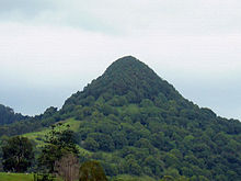 Mount Chincogan near Mullumbimby
Mullumbimby is about 4 kilometres (2 mi) west of the Pacific Highway, near where the Sydney via Lismore to Murwillumbah railway line crosses the Brunswick River. The line opened in 1894 and was closed in 2004 because of an argument over funding between Federal and State politicians, and despite strong community resistance across the region. Closure of the railway line between Murwillumbah and Casino has reduced transport options in the region. Mullumbimby is close to the towns of Ocean Shores, Brunswick Heads and Wilsons Creek.
Counter culture
The Mullumbimby town and surrounding area became a centre of alternative or counter culture in the 1970s and 1980s, alongside existing mainstream society, as did nearby Byron Bay and remains so today.
Mullumbimby was a separate municipality from 1908 until 1980 when it was forced to amalgamate with the Byron Shire. The Byron Shire Council offices were relocated to Mullumbimby in the 1990s.
A static inverter plant of HVDC Directlink is located near Mullumbimby. This inverter plant was previously the site of a hydroelectric power scheme generating electricity, that powered Mullumbimby and Byron Bay from 1926, using water from a weir in nearby Wilsons Creek. [9] The hydroelectric scheme was designed by William Corin (1867–1929).[10]
References
- ^ Australian Bureau of Statistics (25 October 2007). "Mullumbimby (State Suburb)". 2006 Census QuickStats. http://www.censusdata.abs.gov.au/ABSNavigation/prenav/LocationSearch?collection=Census&period=2006&areacode=SSC18233&producttype=QuickStats&breadcrumb=PL&action=401.
- ^ "NSW Elec toral District - Ballina". Electoral Commission NSW. 2007. http://www.elections.nsw.gov.au/state_government_elections/electoral_districts/all_districts_/ballina.
- ^ "NSW Electoral District - Lismore". Electoral Commission NSW. 2007. http://www.elections.nsw.gov.au/state_government_elections/electoral_districts/all_districts_/lismore.
- ^ "Federal Division - Richmond". Australian Electoral Commission. 2007. http://apps.aec.gov.au/esearch/LocalitySearchResults.aspx?filter=richmond&filterby=Electorate.
- ^ "Mullumbimby". Byron Bay Beaches. http://www.byron-bay-beaches.com/mullumbimby.html. Retrieved 20 May 2011.
- ^ "Byron Bay Hinterland". Australian Traveller. http://www.australiantraveller.com/destinations/nsw/byron-bay/2887. Retrieved 11 May 2011.
- ^ "PLACE NAMES.". The Australian Women's Weekly (1932-1982) (1932-1982: National Library of Australia): p. 61. 13 May 1964. http://nla.gov.au/nla.news-article55185386. Retrieved 22 February 2011.
- ^ "Mullumbimby". Geographical Names Register of NSW. http://www.gnb.nsw.gov.au/name_search/extract?id=ujjLwptLMa. Retrieved 26 October 2011.
- ^ "Mullumbimby". The Sydney Morning Herald. 2004-02-08. http://www.smh.com.au/news/New-South-Wales/Mullumbimby/2005/02/17/1108500197710.html.
- ^ http://www.adb.online.anu.edu.au/biogs/A080128b.htm
Categories:- Towns in New South Wales
- North Coast, New South Wales


Wikimedia Foundation. 2010.