- Côte-Nord
-
Côte-Nord — Region — Map of Côte-Nord in relation to Quebec.
Coordinates: 50°52′N 65°49′W / 50.867°N 65.817°WCoordinates: 50°52′N 65°49′W / 50.867°N 65.817°W Country  Canada
Province  Quebec
Area[1][2] – Total 300,281.83 km2 (115,939.5 sq mi) – Land 247,627.06 km2 (95,609.3 sq mi) Total area includes disputed land within Labrador Population (2006)[2] – Total 95,911 – Density 0.4/km2 (1/sq mi) Website www.cotenord.gouv.qc.ca 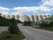 Barrage Daniel-Johnson, a hydroelectric dam on the Manicouagan River.
Côte-Nord (French for "North Shore", area 247,627.06 km², or 95,609.34 sq mi) is the second largest administrative region by land area in Quebec, Canada, after Nord-du-Québec. It covers much of the northern shore of the Saint Lawrence River estuary and the Gulf of Saint Lawrence past Tadoussac.
While most of the region is in the same time zone as the rest of Quebec, the far eastern portion east of the 63rd meridian, including half of Anticosti Island, is officially in the Atlantic Time Zone.
Contents
Population
As of the 2001 census, the population amounted to 97,766, slightly more than 1% of the province's population, spread across 25 municipalities. The towns of Baie-Comeau and Sept-Îles combined amount to a little more than half of the population of the region.
Geography and economy
Côte-Nord was created as an administrative region in 1966. Important landmarks of Côte-Nord include Anticosti Island, the Mingan Archipelago, and the Manicouagan Reservoir.
A territorial dispute between Quebec and Newfoundland and Labrador concerning the border between Côte-Nord and Labrador has existed since 1927.
The region's economy is based on mining (mostly iron), lumbering, aluminum production, and tourism. Côte-Nord's fourteen hydroelectric dams, notably the Manicouagan-Outardes complex, supply Hydro-Québec with over 10,500 megawatts of power.
Subdivisions
Regional county municipalities
- Caniapiscau
- La Haute-Côte-Nord
- Le Golfe-du-Saint-Laurent
- Manicouagan
- Minganie
- Sept-Rivières
Indian reserves
Naskapi reserved territory
Major communities
- Baie-Comeau
- Chute-aux-Outardes
- Fermont
- Forestville
- Havre-Saint-Pierre
- Les Escoumins
- Pointe-aux-Outardes
- Pointe-Lebel
- Port-Cartier
- Sacré-Coeur
- Sept-Îles
See also
References
- ^ Ministère des Affaires Municipales, Régions et Occupation du territoire
- ^ a b Statistics Canada 2006 Census
External links
Administrative divisions of Côte-Nord (Region 09)Regional county municipalities
and equivalent territoriesLa Haute-Côte-Nord · Le Golfe-du-Saint-Laurent · Manicouagan · Sept-Rivières · Caniapiscau · Minganie
Municipalities Forestville · Baie-Comeau · Sept-Îles · Port-Cartier · Havre-Saint-Pierre · Fermont · Schefferville
Administrative divisions of QuebecSubdivisions Communities Major cities Montreal · Quebec · Laval · Gatineau · Longueuil · Sherbrooke · Saguenay · Lévis · Trois-Rivières
Regions Abitibi-Témiscamingue · Bas-Saint-Laurent · Capitale-Nationale · Centre-du-Québec · Chaudière-Appalaches · Côte-Nord · Estrie · Gaspésie–Îles-de-la-Madeleine · Laval · Lanaudière · Laurentides · Mauricie · Montérégie · Montréal · Nord-du-Québec · Outaouais · Saguenay–Lac-Saint-Jean
Categories:


Wikimedia Foundation. 2010.