- Metlakatla, Alaska
-
This article is about the Metlakatla in Alaska. For "Old Metlakatla" in British Columbia, see Metlakatla, British Columbia.
Metlakatla, Alaska — CDP — Location of Metlakatla, Alaska Location of Metlakatla in the state of Alaska, United States
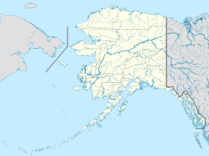
 Metlakatla, Alaska
Coordinates: 55°7′37″N 131°34′35″W / 55.12694°N 131.57639°WCoordinates: 55°7′37″N 131°34′35″W / 55.12694°N 131.57639°W Country United States State Alaska Borough Unorganized Census Area Prince of Wales-Hyder Area – Total 2.3 sq mi (6.1 km2) – Land 2.3 sq mi (6.0 km2) – Water 0.0 sq mi (0.1 km2) Elevation 3 ft (1 m) Population (2000) – Total 1,375 – Density 593.4/sq mi (229.1/km2) Time zone Pacific (PST) (UTC-8) Area code(s) 907 FIPS code 02-48870 GNIS feature ID 1423661 Metlakatla (
 /ˌmɛtləˈkætlə/) is a census-designated place (CDP) on Annette Island in Prince of Wales-Hyder Census Area, Alaska, United States. At the 2000 census the population was 1,375.
Contents
History
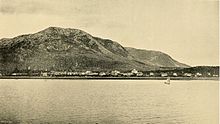 Metlakatla as it appeared in the 1890s.
Metlakatla comes from Maxłakxaała, a Tsimshian word meaning "Salt Water Passage." Metlakatla was named after another village of the same name ("Old Metlakatla") in British Columbia, which is on Metlakatla Pass, near Prince Rupert. In a more ancient time, it was a Tlingit hunting ground known as "Taquan". The Tsimshians were granted permission to own the land by Chief Johnson of the Tlinget tribe.
In 1886, William Duncan, an English tannery employee and lay minister of the Anglican Church, had a doctrinal dispute with the Church authorities in Metlakatla, B.C. He and a devoted group of Tsimshian followers decided to leave Metlakatla. Duncan went to Washington, D.C., in the United States and asked the U.S. government to give his group land in Alaska. The U.S. under President Cleveland gave them Annette Island after a search committee in sea-going canoes discovered its calm bay, accessible beaches, nearby waterfall, and abundant fish.[1]
In 1887 the group arrived on the island and built a settlement in the Port Chester area of the island. The town was laid out in a neat grid pattern and contained a church, a school, a tannery, and a sawmill. They named the town New Metlakatla, after the town they had left behind, but later dropped the "New". In 1888, William Duncan returned to Washington and lobbied the U.S. Congress for an Indian reservation on Annette Island. Although the reservation system had not been used in Alaska, this request was granted in 1891. Annette Island and its surrounding islands today comprise the only Indian reservation in Alaska. Duncan remained at Metlakatla until his death in 1918.
During World War II, a large airfield was built on Annette Island. This airfield became "the first Canadian force ever based in U.S. territory to directly assist in American defense." After the war it became a United States Coast Guard search and rescue base.[2] This airfield served the area commercially until the 1970s when the new Ketchikan Airport was built at Gravina Island in the Inside Passage.
Travelers into Metlakatla usually reach it the Alaska Marine Highway ferry or by traveling to Ketchikan, on Revillagigedo Island and crossing the Revillagigedo Channel that separates Annette and Revillagigedo Islands by boat or seaplane.
Since 1997, a joint task force under the command and control of Alaska Command and led by the Missouri Army National Guard has worked at constructing a 15-mile road from one side of Annette Island to the other. Members of the Active and Reserve Components of the Army, Navy, United States Air Force, and the Marines have rotated through the island working to build the road.[3] The military completed its work on the project in 2007. The project is the result of a 50-year old treaty promising the Metlakatla Indian Community a road connecting their ocean-side city to Alaska's inside passage, to allow year-round ferry service to Ketchikan.
Geography
Metlakatla is located at 55°7′37″N 131°34′35″W / 55.12694°N 131.57639°W (55.126916, -131.576393)[4]. It is on the Port Chester harbor, on Annette Island, about 25 km (16 mi) south of Ketchikan.
According to the United States Census Bureau, the CDP has a total area of 2.3 square miles (6.0 km2), of which, 2.3 square miles (6.0 km2) of it is land and 0.04 square miles (0.10 km2) of it (0.85%) is water.
Demographics
As of the census[5] of 2000, there were 1,375 people, 469 households, and 338 families residing in the CDP. The population density was 593.4 people per square mile (228.8/km²). There were 531 housing units at an average density of 229.2/sq mi (88.4/km²). The racial makeup of the CDP was 9.53% White, 0.22% Black or African American, 81.82% Native American, 0.07% Asian, 0.51% from other races, and 7.85% from two or more races. 1.82% of the population were Hispanic or Latino of any race.
There were 469 households out of which 38.8% had children under the age of 18 living with them, 48.0% were married couples living together, 15.6% had a female householder with no husband present, and 27.9% were non-families. 23.5% of all households were made up of individuals and 6.6% had someone living alone who was 65 years of age or older. The average household size was 2.93 and the average family size was 3.50.
In the CDP the age distribution of the population shows 33.1% under the age of 18, 9.4% from 18 to 24, 28.7% from 25 to 44, 21.6% from 45 to 64, and 7.2% who were 65 years of age or older. The median age was 31 years. For every 100 females there were 108.3 males. For every 100 females age 18 and over, there were 115.0 males.
The median income for a household in the CDP was $43,516, and the median income for a family was $49,671. Males had a median income of $36,696 versus $22,292 for females. The per capita income for the CDP was $16,140. About 7.7% of families and 8.0% of the population were below the poverty line, including 9.7% of those under age 18 and 6.3% of those age 65 or over.
Population of Metlakatla[6] Year Population 1940 700 1960 800 1970 1,100 1980 1,100 1990 1,400 2000 1,375[7] Education
In 2007, Richard Johnson Elementary School in Metlakatla was named a National Blue Ribbon School.[8]
See also
Metlakatla Seaplane Base (IATA: MTM, ICAO: PAMM, FAA LID: MTM)
References
- ^ "Community Origins." Metlakatla Indian Community. 2005. Web. Retrieved 24 Aug. 2011.
- ^ Lundberg, Murray. "Annette Island, Alaska in World War II." Explore North. 2009. Web. Retrieved 24 Aug. 2011.
- ^ [1] Fact Sheet, Operation Alaska Road, retrieved 06 February 2008
- ^ "US Gazetteer files: 2010, 2000, and 1990". United States Census Bureau. 2011-02-12. http://www.census.gov/geo/www/gazetteer/gazette.html. Retrieved 2011-04-23.
- ^ "American FactFinder". United States Census Bureau. http://factfinder.census.gov. Retrieved 2008-01-31.
- ^ [2]
- ^ "US Census Bureau FactFinder: Alaska by Place". United States Census Bureau. http://factfinder.census.gov/servlet/GCTTable?_bm=y&-geo_id=04000US02&-_box_head_nbr=GCT-PH1&-ds_name=DEC_2000_SF1_U&-format=ST-7. Retrieved March 23, 2010.
- ^ "2007 No Child Left Behind - Blue Ribbon Schools: All Public Elementary Schools" (PDF). US Department of Education. http://www2.ed.gov/programs/nclbbrs/2007/public-elementary.pdf. Retrieved March 1, 2011.
External links
Municipalities and communities of Prince of Wales-Hyder Census Area, Alaska Cities Coffman Cove | Craig | Hydaburg | Kasaan | Klawock | Thorne Bay
CDPs Edna Bay | Hollis | Hyder | Metlakatla | Naukati Bay | Point Baker | Port Protection | Whale Pass
Unincorporated
communityCategories:- Populated places in Prince of Wales – Hyder Census Area, Alaska
- Census-designated places in Alaska
- Populated places in Alaska with Native American majority populations


Wikimedia Foundation. 2010.