- Craighill Channel Upper Range Front Light
-
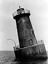
Craighill Channel Upper Range Front Light 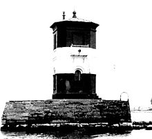
undated photograph of the Craighill Channel Upper Range Front Light (USCG) Location West of Fort Howard (North Point) on the north shore of the Patapsco River Coordinates 39°11′50″N 76°26′54″W / 39.1971°N 76.4482°WCoordinates: 39°11′50″N 76°26′54″W / 39.1971°N 76.4482°W Year first lit 1886 Automated 1929 Foundation stone Construction brick Tower shape square tower Height 15 ft Characteristic Fixed red (originally white) The Craighill Channel Upper Range Front Light is one of a pair of range lights that marks the second section of the shipping channel into Baltimore harbor.
History
Work on the upper range lights commenced in 1885 and was completed in time to allow activation in January 1886. An initial plan to reuse the west North Point Range Light was discarded in favor of a tiny brick structure constructed on the foundation of the old light. The keeper's house was built on the shore, and a long wooden bridge allowed access to the light itself. Initially a locomotive headlight was installed to show a fixed white light.
Three years after improvements to the keeper's house were made in 1890, the bridge to the light was destroyed by a storm. Rather than rebuild it, the headlight was moved to the exterior of the light, and the keeper took up residence in the light itself. The light was electrified and automated in 1929. Although there are some claims that the light was rebuilt in 1938, this is believed to be a misunderstanding based on discrepancies in the reported height of the light over the years.
References
- "Historic Light Station Information and Photography: Maryland". United States Coast Guard Historian's Office. http://www.uscg.mil/history/weblighthouses/LHMD.asp.
- Craighill Range Lighthouses, from the Chesapeake Chapter of the United States Lighthouse Society
- Craighill Channel Upper Front Lighthouse at lighthousefriends.org
External links
- http://www.craighillrange.org
- Rowlett, Russ. "Lighthouses of the United States: Maryland". The Lighthouse Directory. University of North Carolina at Chapel Hill. http://www.unc.edu/~rowlett/lighthouse/md.htm.
- Chesapeake Bay Lighthouse Project - Craighill Channel Range Lights
Craighill Channel (lower) Upper Craighill Channel (cutoff) Seven Foot Knoll Light • Front Range Light • Rear Range LightBrewerton Channel Hawkins Point Light (front range) • Leading Point Light (rear range)Categories:- Lighthouses in Maryland
- Buildings and structures completed in 1886


Wikimedia Foundation. 2010.