- Montclair-Boonton Line
-
The Montclair-Boonton Line is a commuter rail line of New Jersey Transit Rail Operations. It is part of the Hoboken Division. The line is a consolidation of three individual lines: the former Delaware, Lackawanna & Western Railroad's Montclair Branch, which ran from Hoboken Terminal to Bay Street, Montclair; the Erie Railroad's Greenwood Lake Division (segment from Montclair to Mountain View-Wayne), which originally ran from the Erie's Jersey City Terminal to Greenwood Lake, NY; and the former Lackawanna Boonton Line, which ran from Hoboken to Hackettstown, New Jersey. The Montclair-Boonton line was formed when the Montclair Connection opened on September 30, 2002. The line serves 28 active rail stations in New Jersey along with New York Pennsylvania Station. It crosses through six counties, serving six stations in the township of Montclair, two in the town of Bloomfield, and one in the city of Newark. Trains along the Montclair-Boonton Line heading eastward usually originate at Hackettstown station, Mount Olive station, Lake Hopatcong, Dover station, and/or Montclair State University station, bound for either Hoboken Terminal or New York Penn Station.
For 2010, of 31 inbound and 34 outbound daily weekday trains, 21 inbound and 22 outbound Midtown Direct trains (about 66%) use the Kearny Connection to Secaucus Junction and New York Penn Station; the rest go to Hoboken Terminal. Trains to Hoboken run only at rush hour. Passengers can transfer at Secaucus Junction, Newark Broad Street Station, Montclair State University, or Dover to reach other destinations if necessary. Weekend service on the Montclair-Boonton Line began on November 8, 2009, with service every two hours between Bay Street station in Montclair and Hoboken terminal, with the train making all local stops.[1] This was an extension of existing Hoboken-to-Newark service, previously listed on the Morris & Essex timetables.
Plans for connecting the two lines (the New York & Greenwood Lake Railroad (later the Boonton Line) and the Montclair Branch) dated back to 1929, when a rail connection through Montclair was proposed. Despite years of debate over the connection, nothing came to fruition until 1991. Lackawanna Terminal in Montclair closed in 1981, replaced by the new Bay Street station on the alignment that eventually would extend to the connection. In 1991, studies were conducted by New Jersey Transit regarding the creation of the Montclair Connection, and in 2002, after construction was completed, the Boonton Line from east of Walnut Street station to Arlington was abandoned and all trains took the new alignment via the Montclair Branch between a newly-rebuilt Bay Street station and Walnut Street. Service began on September 30, 2002 and three stations on the old Boonton Line were closed, Benson Street in Glen Ridge, Rowe Street in Bloomfield, and Arlington station in Kearny.
Besides the Montclair Connection, service was extended in 1994 from Netcong station to Hackettstown via tracks owned by Norfolk Southern. Stations at Roseville Avenue in Newark, Ampere in East Orange, and Great Notch in Little Falls were closed in 1984, 1991, and 2010 respectively. Two service expansions have been proposed using the under-construction branch to Andover via the Lackawanna Cut-Off project, an extension on old New York and Greenwood Lake tracks to Pompton Junction, and the New York, Susquehanna and Western. There is also a proposal to extend service along the Washington Secondary as a rapid transit improvement to the New Jersey Route 57 corridor via Washington Borough to Phillipsburg.
Contents
History
Montclair Branch (Delaware, Lackawanna and Western)
The Montclair Branch was chartered in 1852 as the Newark and Bloomfield Railroad, running through Bloomfield and nearby West Bloomfield (present-day Montclair). However, tracks were not constructed along the owned right-of-way until 1856; in June of that year trains began running between Newark, Bloomfield, and West Bloomfield. The railroad had a large deficit to start; the ticket agent at West Bloomfield was also the brakeman for the one-car train.[2]
 Watsessing Avenue station on the Montclair Branch pre-depression in 1912
On April 1, 1868, the Morris & Essex Railroad bought out the alignment of the Newark and Bloomfield Railroad.[3] The Morris & Essex began running services on the line, which was renamed the "Montclair Branch" when West Bloomfield was similarly renamed to "Montclair" shortly after. The Delaware, Lackawanna and Western Railroad soon gained trackage rights, and by the turn of the 20th century, the railroad had begun constructing track depressions and raises to eliminate grade-level crossings on city streets.[4][5] In 1912, the Montclair Branch was depressed, elevated, and double tracked, and grade crossings were eliminated. The stations at Watsessing Avenue and Glen Ridge were constructed below street level, while Ampere and Bloomfield stations were constructed above street level. Roseville Avenue station was already depressed, 22 feet (6.7 m) below street level, in 1903.[5]
In June 1913, the new Lackawanna Terminal (named after the Delaware, Lackawanna, and Western) opened in Montclair. William H. Botsford designed it, but did not live to see it open as he died in the sinking of the Titanic in 1912. The brick station building followed a Grecian-Doric style of architecture, which included creative uses of concrete for the arches and dentils. Lackawanna Terminal had six tracks and three concrete platforms, with a large bridge which carried Grove Street in Montclair over the tracks.[5] The Montclair Branch was the first fully electrified suburban railroad, wired in 1930. The inaugural train was driven by Thomas Edison, who had helped develop the line.[6] On July 26, 1945, the Morris & Essex Railroad Company was officially dissolved, and the company became part of the Delaware, Lackawanna, and Western. The lines were then maintained as the Morris & Essex Division.[7]
New York and Greenwood Lake Railroad (Erie)
Main article: New York and Greenwood Lake Railway (1878–1943)See also: Arlington (NJT station), Rowe Street (NJT station), Benson Street (NJT station), and Silver Lake (NLR station) The Mountain Avenue station in Montclair, the only one of the five stations not built in 1872 by the New York & Greenwood Lake
The New York & Greenwood Lake Railway originated as the New York and Montclair Railroad, granted a state charter in 1867 to construct a railroad from Jersey City to the New York state line at Greenwood Lake. The railroad caused the secession of West Bloomfield from Bloomfield, and West Bloomfield renamed itself Montclair. The railroad was completed in 1872 with four stations in Montclair: Montclair, Watchung Avenue, Upper Montclair, and Montclair Heights.[2] The New York & Greenwood Lake Railway became a subsidiary of the Erie Railroad by 1884 and what was once its track is now the Walnut Street – Mountain View stretch of the Montclair-Boonton Line.
The original railroad extended much farther in both directions, encompassing Hoboken Terminal via the former alignment through Montclair, Glen Ridge, Bloomfield, Newark and reaching into Kearny, where it crossed the Hackensack River and the meadowlands into Hoboken. The alignment had two stations in the Arlington section of Kearny: Arlington and West Arlington; Forest Hill and North Newark in Newark; Belwood Park, Rowe Street, Orchard Street, and Walnut Street in Bloomfield, and Benson Street in Glen Ridge. At Forest Hill in Newark, the mainline intersected with its Orange Branch at OJ Tower, constructed in 1897. Orange Branch passenger service was discontinued on May 20, 1955, but freight service lingered until 1979, when the track was removed from White St. in West Orange to the Watsessing section of Bloomfield. Some track remains in service today for the Newark Light Rail, including Silver Lake Station, which was a former station on the branch. The station, today known as Walnut Street, was then known as Montclair-Erie Plaza to differentiate it from the nearby Montclair Lackawanna Terminal. The line also had an extension to Sterling Forest and Ringwood near the state line with New York.[8]
Erie Lackawanna Railroad
On October 1, 1960, the Delaware, Lackawanna, and Western Railroad (DL&W) and Erie Railroad merged to form the Erie-Lackawanna Railroad.[8] In 1963, the old DL&W Boonton Branch was abandoned between Mountain View and Paterson and its right of way was sold for the new Interstate 80 and the current-day New Jersey Route 19. (At the time, NJ 19 was designated New Jersey Route 20; the westernmost segment of NJ 20 connected eastward with what is now New Jersey Route 120, replicating Paterson Plank Road from Jersey City through the Meadowlands, Rutherford, and Clifton to Paterson) A single track could have been retained along the new highways, but the Erie-Lackawanna decided to sell the entire right-of-way as it was strapped for cash.[5] To allow the western end of the Boonton Line access into Hoboken, the east end of the Erie's former Greenwood Lake Branch, between Bergen Junction at Croxton and Mountain View in Wayne, was joined to the west end of the DL&W's former Boonton Line between Wayne and Denville. The line was renamed the Greenwood Lake-Boonton Line in recognition of its two predecessors. The original DL&W east of Clifton was joined with the Erie's Main Line as part of a project to remove tracks through Passaic.[8]
New Jersey Transit
In 1983, the maintenance of the Montclair Branch and the Boonton Line were taken over entirely by New Jersey Transit. The Boonton Line at that point began out of Hoboken Terminal, heading westward through the Jersey Meadows and into Kearny, crossing the Passaic river at West Arlington and going through North Newark, Bloomfield, and Glen Ridge before entering Montclair and continuing on from the current Walnut Street station to Netcong station. The Montclair Branch, designated part of the Morris & Essex Lines, which consisted of the Montclair Branch, Morristown Line, and Gladstone Branch, had six stations: Roseville Avenue in Newark, Ampere in East Orange, Watsessing Avenue in Bloomfield, Bloomfield station, Glen Ridge station, and Bay Street in Montclair. The Montclair Branch was an electrified service; however, the Boonton Line was a diesel line.[9]
Over the next decade, New Jersey Transit closed several stations over the length of the Montclair Branch. The Harrison and Roseville Avenue stations were closed on September 16, 1984;[10] the Ampere station in East Orange was closed less than seven years later, on April 7, 1991.[11] Plans to extend the Morristown Line and Boonton Line westward from Netcong station to Hackettstown were proposed in June 1992 as part of proposed service extension.[12] On November 6, 1994, service was ceremonially extended along Norfolk Southern's Washington Secondary from Netcong Station with the creation of the stops in Mount Olive and Hackettstown.[13] Trackage along those two stations is still Norfolk Southern's, though anything beyond Netcong remains New Jersey Transit's.
Montclair Connection
Main article: Montclair ConnectionIn 2002, New Jersey Transit finished construction of the Montclair Connection, a small set of tracks along Pine Street in Montclair that connected the Boonton Line and the Montclair Branch. The concept of the Montclair Connection had been originated in 1929 by the Regional Plan Association, to connect the New York & Greenwood Lake with the Montclair Branch. However, the Great Depression, which began in 1929, shelved plans for the connection. Three decades after the Erie's Main Line was realigned out of Passaic (in 1963), New Jersey Transit returned to the plan for the Montclair Connection. The original plan was for a one-track diesel connection, but this grew into a two-track electric connection with extension of catenary wires. After negotiations with the township of Montclair, detailed plans and design began in 1998, and construction began just a year later.[6]
 New track alignment to Hoboken curves to the right; old alignment (now single-tracked) veers to the left
When the Montclair Connection was completed in 2002, the names of the Montclair Branch and Boonton Line were eliminated in favor of the labeling the new whole "the Montclair-Boonton Line". Although no stations along the Montclair Branch (Watsessing, Bloomfield, Glen Ridge, and Bay Street) were closed, three stations along the old Greenwood Lake alignment had service end on September 20, 2002: Arlington station, in Kearny, Rowe Street, in Bloomfield, and Benson Street, in Glen Ridge. This alignment was turned over to Norfolk Southern for maintenance.[6] The station building at Benson Street was damaged by a fire in the 1980s and had fallen into disrepair; in May, 2009, it was sold to a private developer and is being rebuilt entirely.[14] During the Montclair Connection's construction, Bay Street station, which was a single platform with only one track, was rebuilt entirely, with two high-level platforms and new tracks.[6]
The new connection also introduced service to New York Penn Station for commuters along the line; trains previously went only to Hoboken Terminal. The new services included diesel service and express trains to Montclair Heights, making stops from Great Notch to Hackettstown, and new Midtown Direct service trains from Montclair Heights to New York, with transfers between them at Great Notch. There was also additional Morristown line Midtown Direct service to New York, available only at Denville and Dover stations.[6] Other upgrades along the line included a revamping of Great Notch Yard for state-of-the-art service. However, no weekend service was implemented on the line.[6]
Montclair State University Station
Main article: Montclair State University (NJT station)On June 10, 2002, Governor of New Jersey James E. McGreevey announced a partnership with Montclair State University (MSU) as part of the Midtown Direct service. On July 18, 2002, partnership announced plans for a new train station and parking facility for commuters in Little Falls.[15] Before the Construction of Montclair State University Station, students at Montclair State University could only use Montclair Heights station to access the campus.[6] Construction of the station was delayed by lawsuits from the township of Montclair because of residential displacement and parking issues. The station was proposed with a 1300-space parking deck and a cost of $36 million (2002 USD). The $36 million came entirely from the New Jersey Economic Development Authority in bonds to Montclair State University.[16]
On October 20, 2004, the new Montclair State University Station at Little Falls opened in a ceremony led by executive director George Warrington and MSU president Susan Cole. The new station had a parking deck with 1500 spaces, reducing road congestion.[17] This differed from the original proposal, which had called for 1,300 parking spaces.[15] Electrified service was then extended from Montclair Heights station north a mile to Montclair State University, although catenary wires continue westward to the former Great Notch station.[6]
Wayne–Route 23 and Mount Arlington stations
Main articles: Wayne-Route 23 (NJT station) and Mount Arlington (NJT station)Prior to 2008, the only station in Wayne was the downtown Mountain View station. The only station in the area around Lake Hopatcong was Lake Hopatcong station in Landing (this station has been referred to on timetables as Lake Hopatcong-Mount Arlington). In 2008, both the Wayne-Route 23 Transit Center and Mount Arlington Intermodal Train Station and Park & Ride opened.[8]
Wayne-Route 23 is located in Wayne, near the Westbelt Mall at the U.S. Route 46, Interstate 80, Route 23 interchange; this was also the site of the Singac station, which closed four decades before the new transit center opened.[8] On September 13, 2006, construction of the $16.3 million project was announced; the general contractor was J.H. Reid of South Plainfield. The new station was built to reduce traffic on nearby highways, by diverting commuters to trains or buses.[18]
Construction on Mount Arlington Station, which was already a parking lot with 228 spaces for Lakeland Bus, began on April 12, 2006. The new train station was built to relieve traffic on Interstate 80, and 57 new parking spaces were added to the lot. The project was slated to cost $12.1 million, and the contract was given to Terminal Construction Corporation of Wood-Ridge.[19] Both stations were completed within nine days of each other: the Wayne-Route 23 Transit Center opened on January 12, 2008, with train service beginning two days later;[20] Mount Arlington Station opened on January 21, 2008, and is the newest station on the line.[21]
Weekend service
In 2002, after construction on the Montclair Connection was completed, there was no weekend service on the new Montclair-Boonton Line.[6] Over the ensuing six years, officials from Montclair urged New Jersey Transit to offer weekend service on the Montclair-Boonton Line, which was the only NJT line without it. Montclair Township's proposal cited the benefits of weekend service to the communities along the line, including reduced traffic congestion and carbon footprint. The agency repeatedly declined to expand the service because Montclair limited the use of train horns between 7 pm and 7 am. New Jersey Transit had received requests for weekend service since 2007, and denied them citing capacity issues and turning off electric power for bridge replacement. Advocates have dismissed these reasons as "excuses" and locals said it would improve their quality of life.[22]
On September 30, 2009, New Jersey Transit announced service every two hours between Bay Street station and Hoboken Terminal, a 20-minute trip. The service started on November 8, 2009 with a ceremony at Bay Street station in Montclair.[23]
Closure of Great Notch
Main article: Great Notch (NJT station) Great Notch Station looking towards Hackettstown prior to closure
Great Notch was a small station on the south side of Long Hill Road (Passaic County Route 631) in Great Notch. The station dated back to 1905 as a transfer point between the New York & Greenwood Lake and its Caldwell Branch to Essex Fells, New Jersey.[8] The station was important in its heyday, but after the opening of Montclair State University station in 2004, about a mile away, ridership at the old station, which had only 69 parking spaces,[6] began to dwindle. By January 2008, only one train inbound to Hoboken and two trains outbound towards Hackettstown/Dover stopped at Great Notch.[24] In August 2008, New Jersey Transit approached the community of Great Notch, part of Little Falls, saying that the 103-year-old station would be closed by October.[25] After a few days, there was public protest against the possible closure, and on September 3, a public meeting was held to strike a deal with residents.[26]
On April 1, 2009, after negotiations with Michael DeFrancisci, the mayor of Little Falls, the station and town were given a "one-year test" to attract ridership at the small station. The quota to keep the station open was 67 people using the station by December 31, 2009 and 100+ by April 1, 2010.[27] On December 18, 2009, the test was canceled when Little Falls was informed by New Jersey Transit that the Great Notch Station would be closed on January 17, 2010 due to the anemic ridership at the station.[28] New Jersey Transit cited in a press release that the station only was receiving an average of nine boardings daily. The remaining passengers were directed to use either Montclair State University station or Little Falls station.[29]
Service extensions
 Port Morris ("UN") Tower has not seen a train pass in over a decade in this photo. The connection to NJ Transit's Montclair-Boonton Line to New York is a short distance past the tower
According to the 2020 Transit: Possibilities For The Future report produced by New Jersey Transit in October 2000, the Montclair-Boonton Line is a candidate for further rail expansion beyond the Montclair Connection.[30] The Lackawanna Cut-Off, a project from Lake Hopatcong to Scranton, Pennsylvania, is to start off as the Andover Branch off Montclair-Boonton Line trains. The Lackawanna Cut-Off was a former Delaware, Lackawanna, and Western line used from 1911 to 1970. As part of the Minimal Operable Segment (MOS), only a 7.3-mile (11.7 km) stretch to Andover, New Jersey is to be active.[31] Passenger trains will use an upgraded alignment from the Montclair-Boonton/Morristown mainline at Port Morris Junction with several Montclair-Boonton trains taking the junction to Andover.[32]
The report also cited the study of extending service on the Montclair-Boonton from the current Hackettstown station, a single-sided platform in downtown Hackettstown along the current Washington Secondary, maintained by Norfolk Southern to Phillipsburg, New Jersey via Washington.[30] One of two extensions proposed to Phillipsburg, the line would follow New Jersey Route 57 through Port Murray, Rockport, Washington, Stewartsville, and into Phillipsburg,[33] where it would meet an extended Raritan Valley Line.[30] Locals have expressed support for the extensions on the active Class I freight line, and would use automobiles to get to the stations' newly-designed park and rides. The expansion of passenger service on the Washington Secondary is a small part of new public transport on the Route 57 corridor, an attempt to attract service past Hackettstown from the northern New Jersey and New York corridors. However, the candidate project has not yet been funded by New Jersey Transit.[34]
The third and final extension relates to the possibility of using the New York and Greenwood Lake trackage from Mountain View station northward to the old Pompton Junction station.[30] The project, called the Pompton Extension, is part of an effort to connect service from the Montclair-Boonton to the candidate rail service to Sparta, New Jersey on the New York, Susquehanna and Western Railroad. This service would connect the stations at Pequannock, Pompton Plains, Pompton and connect at the Pompton Junction, the site of the former Pompton Junction station.[8] However, unlike the other projects, the Pompton Extension is still in study and not a candidate for funding.[30]
Route guide
East of Bloomfield
 The remnants of Roseville Avenue station in 2010, 26 years after closingSee also: Newark Broad Street Station, Roseville Avenue (NJT station), and Ampere (NJT station)
Train service on the Montclair-Boonton Line begins at either Hoboken Terminal, which includes all weekend service, or New York Penn Station. From there, trains use the alignment of the Morristown Line west through the Bergen Tunnels from Hoboken, over the Lower Hack Lift bridge across the Hackensack River. After crossing the Hackensack, the lines pass through Kearny and Harrison. Harrison was the site of a passenger station built in 1904 during the track-raising project by William Truesdale, which started in 1901.[5]
 Ampere Station site, taken almost 19 years after closing
From Harrison, the lines cross over the Passaic River and along Bridge 7.48, a swing drawbridge built in 1901, where they enter the city of Newark and stop at Newark Broad Street Station. Broad Street Station is the first station in active service after Secaucus Junction. Continuing through Newark, the station enters the Roseville district of Newark, where the former Roseville Avenue station was located. Roseville Avenue was constructed in 1905, during the track depression through Roseville along the Morris & Essex Lines. Roseville Avenue Station had two separate sets of platforms (one for the Montclair Branch and one for the Morris & Essex Lines).[5] Although the station was closed on September 16, 1984,[10] the Roseville Tower remained until it was demolished in 2002 to make way for the Montclair Connection.[5] At Roseville Avenue station, the Montclair-Boonton Line and Morris & Essex Lines diverge, with the Morris & Essex continuing west to Summit and points west, while the Montclair-Boonton turns to the north through Roseville and into the community of East Orange, where it crosses through the Ampere district.[33]
Near the intersection of Springdale Avenue and Ampere Parkway, trains pass through the site of the former Ampere Station. Ampere was built around 1909 and remained in use during New Jersey Transit days until April 7, 1991, when along with Grove Street, the station was closed.[11] From here, the lines continue into Bloomfield.[33]
Bloomfield and Glen Ridge
 Watsessing Avenue Station as viewed from its Hackettstown/Montclair platform
After crossing from East Orange into Bloomfield, the Montclair-Boonton Line almost immediately enters its next station (and its first past Newark Broad Street), the Watsessing Avenue station. The station is on an open cut, and is one of two stations that were built underground during the grade crossing elimination in 1912.[5] After crossing under Watsessing Avenue (and Dodd Street), the lines continue northward, crossing under the Garden State Parkway between the northbound and southbound toll plazas of Exit 148. After traversing Watsessing Park, the tracks return to being above-ground and enter Bloomfield Station. The current Bloomfield station was constructed in 1912 during grade crossing elimination, when tracks were raised above street-level.[5] From here, the station continues northwestward, paralleling Toney's Brook through Bloomfield (to the southeast of Bloomfield Avenue). After a short distance, the tracks head back below street level and enter the community of Glen Ridge.[33] At the overpass with Ridgewood Avenue (Essex County Route 653), the line enters the namesake Glen Ridge station. Glen Ridge contains two platforms, and its station building, built in 1912,[5] is above track level, similar to Watsessing Avenue.[5] After Glen Ridge station, the Montclair-Boonton Line continues west before crossing under Bloomfield Avenue (County Route 506) and entering Montclair.[33]
Montclair
 Watchung Avenue Station facing towards the Hackettstown-direction
After crossing under Bloomfield Avenue the Montclair-Boonton Line enters the namesake community of Montclair. It leaves the DL&W alignment and curves rightward into Bay Street station just after Bloomfield Avenue. Bay Street is the newest station on the Montclair Branch portion of the Montclair-Boonton Line, built in 1981 to replace the nearby Lackawanna Terminal, which was becoming a "white elephant". This station is the north end of service on weekends. After Bay Street the line parallels Pine Street on new track to join the Erie (NY&GL) alignment. After the merge near the intersection of Pine Street and Grant Street the line continues north and enters Walnut Street station near Erie Park (named after the Erie Railroad that once used the rails). The current Walnut Street station was built in 1952 as Montclair station after the larger structure was demolished. This station is the first of the five along the New York & Greenwood Lake portion of the Montclair-Boonton Line and has two low side platforms at grade.[8]
The lines parallel Erie Street, once again named after the predecessor railroad, continuing north through several parks in Montclair. After Woodman Field the line enters the Watchung Avenue station, the third of six stations in Montclair.[33] Watchung Avenue Station was built in 1901 as an Erie Railroad Type V station (according to the 1920 Interstate Commerce Report for the Erie), separated by less than a mile from the nearby stations.[8] Watchung Avenue station has two low platforms on embankments and sits next to a bridge over the namesake Watchung Avenue.
Upper Montclair
See also: Upper Montclair (NJT station), Mountain Avenue (NJT station), and Montclair Heights (NJT station)The tracks continue northward across the bridge and Valley Road where they enter the Upper Montclair district. The tracks parallel Anderson Park before crossing Bellevue Avenue and entering the Upper Montclair station. Upper Montclair is the fourth station in Montclair, also having two low platforms. The old Type V station building, built in 1898, suffered a fire on February 5, 2006.[8] The station building is being rebuilt, although larger than the original. Although a planned re-opening was set for the weekend of February 14, 2010,[35] the new Upper Montclair station was ceremoniously reopened by New Jersey Transit and state officials, along with Montclair mayor Jerry Fried on June 18, 2010.[36]
 Montclair Heights Station facing northward towards Montclair State University station
After Upper Montclair station the tracks turn northeast, crossing under Lorraine Avenue, and paralleling Valley Road. The line continues northward paralleling Upper Mountain Avenue through the Upper Montclair district. A short distance later, the tracks enter Mountain Avenue, the next to last station in Montclair. Mountain Avenue has two low platforms, and the nearby station building, which is rented by New Jersey Transit as a private residence.[37] The building was constructed in 1889 by the New York & Greenwood Lake as an irregular shape, similar to Benson Street station on the former Boonton Line alignment east of Montclair.[8] After Mountain Avenue the tracks continue northward through Upper Montclair, passing through Mountainside Park and crossing Mount Hebron Road.[33]
After Mount Hebron Road, the tracks pass a bird sanctuary and enter the Montclair Heights station.[33] The final station in Montclair, Montclair Heights has a mini-high ADA ramp and low platforms. The original station building was constructed in 1905 under an Erie Type V design, until closure in 1959 by the Erie Railroad for economic reasons.[8] The station is also signed as the "Home of Montclair State University". The station itself is at the south end of the campus and was the transfer station until the namesake station for the college opened in 2004.[38] After Montclair Heights, the trains cross town lines, leaving Montclair in favor of Little Falls, New Jersey.[33]
Montclair State University, Great Notch and Little Falls
See also: Montclair State University (NJT station), Great Notch (NJT station), and Little Falls (NJT station)Along the southern end of Montclair State University, the Montclair-Boonton Line crosses out of Montclair north of Montclair Heights station and into the town Little Falls. The tracks head northward, paralleling Long Hill Road (Passaic County Route 631) through the university campus. From there, the road begins a parallel along Clove Road and soon enters the final active electrified station along the Montclair-Boonton Line until Denville, Montclair State University station (officially known as the Montclair State University Station at Little Falls).[33] The station is the set transfer between electric and diesel service, as people heading westward to Dover or Hackettstown need to transfer for further service. The station has a large island platform and also has a 1530-space parking garage on campus.
 Little Falls station viewed from the 1915 station building
A short distance after Montclair State University, the tracks turn to the northwest, leave campus grounds and cross over Clove Road. The tracks loop around campus and pass Great Notch Yard and the site of the now-closed Great Notch station. Great Notch was a one platform station in the Great Notch district of Little Falls. The station consisted of a shelter (which replaced a building built in 1905[8] and burned down in 1988[39]) and benches. After ridership at the station became "anemic",[24] Great Notch was shut down on January 17, 2010,[29] with the last train departing two days prior. Great Notch and its Yard serve as the end of the electrified catenary wires above on the Montclair-Boonton Line.[8] This station was also the site of the transfer to the Erie's Caldwell Branch to Essex Fells, New Jersey,[40] torn up in 1979.[41]
After Great Notch, the tracks continued southwestward through Little Falls, crossing under Long Hill Road (CR 631) and Francisco Road (CR 612) before making a curve back to the northwest at a siding on Cedar Grove Road. The tracks then go over a curved bridge over the Peckman River. The northwestern-bound tracks enter downtown Little Falls, paralleling New Jersey Route 23 into the namesake Little Falls station at Union Boulevard (CR 646).[33] Little Falls is a one low platform station, with the original building, constructed in 1915,[8] standing on the single platform. The station has a 194-spot parking lot and the brick building is used as a waiting room. After the station, the tracks continue northwestward, approaching the Passaic River once again at the community of Singac. The community of Singac is the former site of the namesake Singac Station, which has been out of service for quite a while.[40] After the Passaic, the tracks enter the town of Wayne.[33]
Wayne-Route 23 and Mountain View
See also: Wayne-Route 23 (NJT station) and Mountain View (NJT station) Mountain View station in the Mountain View section of Wayne, facing northbound towards MV Junction
After crossing County Route 631 for yet a third time in Singac, the tracks cross over the Passaic River and enter Wayne, New Jersey. There, the tracks parallel Route 23 near Willowbrook Mall and through the interchange between Route 23, U.S. Route 46, and Interstate 80. After crossing under Interstate 80, the tracks parallel Route 23 and into Westbelt, where the tracks enter the second-newest station on the line, the Wayne-Route 23 Inter-modal Transit Center. Wayne-Route 23 opened on January 12, 2008 with a single high platform and the nearby bus terminal. Wayne-Route 23 Transit Center also contains 1,000 parking spaces for use by travelers.[20]
After leaving Wayne-Route 23, the tracks continue to parallel Route 23 and enter downtown Wayne. The tracks cross Fayette Avenue Park and parallel the Pequannock River into the U.S. Route 202 and Route 23 in the downtown portion. After paralleling Fayette Avenue, the tracks enter Mountain View station. Mountain View station has one low platform and serves as the station for downtown Wayne. The station building at Mountain View was built in 1910 as an Erie Type 4 station (according to the ICC reports), but by 1965 had been replaced by a simple Armco shelter. Mountain View also was also the site of the New York & Greenwood Lake's extension to Wanaque, New Jersey.[8] From this point, the Montclair-Boonton Line follows the alignment of the Delaware, Lackawanna and Western Railroad's Boonton Branch.[5]
Lincoln Park to Mountain Lakes
See also: Lincoln Park (NJT station), Towaco (NJT station), Boonton (NJT station), and Mountain Lakes (NJT station) The Lincoln Park station and its lone platform facing westbound heading towards the 1904 station
West-northwest of the curve, the present line is back on the Delaware, Lackawanna and Western's Boonton Branch original alignment. This parallels U.S. Route 202 (the Boonton Turnpike) through Wayne. The alignment crosses the Pequannock River once again, entering Lincoln Park, New Jersey. After crossing under Ryerson Road, the alignment heads westward through an empty portion of Lincoln Park until entering the namesake Lincoln Park station. Lincoln Park station has a low platform and the station building, a Type W-103 station built in 1904.[5] The tracks continue westward, paralleling U.S. Route 202 through Lincoln Park and making a curve into Montville, New Jersey. In Montville, the tracks head to the southwest through the Towaco district. The tracks continue, paralleling and crossing under Route 202 before entering the Towaco station.[33] Towaco's station building was constructed in 1911 and serves as the only station in Montville, with one low platform for the single track.[5]
 Denville Station's Montclair-Boonton specific platform. The Morristown Line platform is visible to the left
The tracks continue westward through Montville, paralleling and crossing U.S. Route 202 once again. Just before the overpass of Interstate 287, the tracks pass the site of the original Montville station. Montville was constructed in 1903 as a Type W-1 frame station and cost only $2400.[5] The tracks cross under Interstate 287 and make a gradual turn to the southwest. There, the line parallels U.S. Route 202 and Interstate 287 south of the Taylortown district until entering Boonton. After crossing Wooton Street, the tracks enter the Boonton station.[33] Boonton station was originally much longer, with the brick and slate station constructed in 1905 as the largest community on the Boonton Line since Paterson.[5] The station currently has a relatively-short low platform, brick head-house shelter and a mini-high ADA ramp. After Boonton station, the tracks continue to the southeast, paralleling Interstate 287 and U.S. Route 202 out of Boonton and into Intervale. At Intervale, Interstate 287 and U.S. Route 202 turn to the southeast and away from the rail line, which continues southwestward into Mountain Lakes. At the intersection of Midvale Road and Elm Road, the tracks enter the namesake Mountain Lakes station.[33] Mountain Lakes has a single low platform used for train service, while its station building, built in 1912 sits nearby as a restaurant.[42]
Denville to Mount Arlington
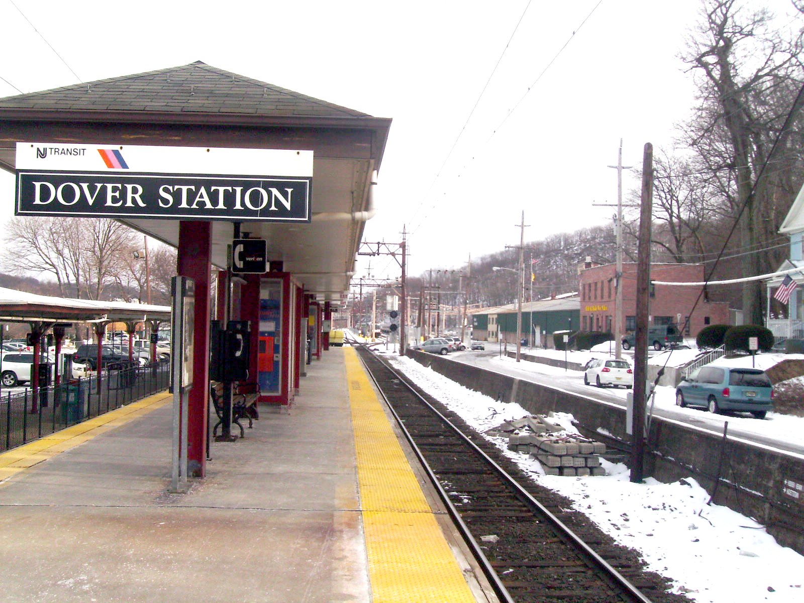
 Dover Station facing eastward along its island platform
After Mountain Lakes station, the Montclair-Boonton Line continues westward through Mountain Lakes and parallels Pollard Road. The alignment crosses U.S. Route 46 and heads to the northwest along Route 46 through the Rainbow Lakes. The line crosses under Interstate 80 and intersecting with the former Delaware, Lackawanna and Western's Rockaway Branch (discontinued in 1948[5]), where the station enters the one platform on the north end of Denville station. The Denville station is built for two lines and has two separate platforms, including one for the Morristown Line, which merges nearby. Denville station had a Type W-3 Delaware, Lackawanna and Western-style wooden frame station built in 1904, which has since been razed. The shell of Denville Tower still stands, and is used as a communications center for New Jersey Transit.[5] After Denville, electrified service begins once again, heading westward across Estling Lake and Franklin Lake before continuing along the Route 46 corridor and into Dover. After Mountain Park, the line crosses through Dover Yard, which is a six storage track station. A short distance after the park and yard, the tracks enter the Dover station. Dover was constructed from 1899–1901, opening on November 1, 1901 and was a two side platform station.[5] Current Dover Station still has its building from the Delaware, Lackawanna and Western, but the station's two side platforms have been replaced by a high-level island platform.
 The Lake Hopatcong station facing westward towards Mount Olive
After departing the Dover station, the Morristown Line catenary wires end about a half-mile west, near the US Route 46 overpass. Afterwards, the tracks parallel Dickerson Street before turning to the northwest through Dover until Morris Duffy School before turning westward into Wharton. The tracks then cross the site of the former Delaware, Lackawanna and Western Railroad station in Wharton, built in 1900. The station was a Type W-101A Delaware, Lackawanna and Western-style, back when the town was named Port Oram, but the station was out of service by 1962.[43] After Wharton station, the tracks continue westward, crossing over Berkshire Valley Road (Morris County Route 699) and parallel Interstate 80 through Morris County, entering the Mount Arlington station at Interchange 30. Mount Arlington station is the newest station along the Montclair-Boonton Line, opening on January 21, 2008, nine days after opening of Wayne-Route 23. Mount Arlington has two high-level platforms serving two tracks. The station is also a park & ride, serving bus service from Lakeland Bus and 285 parking spaces.[21]
Lake Hopatcong to Hackettstown
See also: Lake Hopatcong (NJT station), Netcong (NJT station), Mount Olive (NJT station), and Hackettstown (NJT station) Netcong Station heading eastward towards Lake Hopatcong
After paralleling Interstate 80 out of Mount Arlington station, the line heads southwestward until turning northeastward through the community of Landing. From there, the line goes northward along Morris County Route 631 heading into downtown Landing, where the tracks turn northeastward. The tracks soon enter the Lake Hopatcong station. Lake Hopatcong has two low platforms with a shelter on the westbound side. The original Delaware, Lackawanna and Western station was much larger, built in 1911 to replace the original Hopatcong stop. The original station had two large towers and two long concrete platforms to access from the original 1911 station on Landing Road.[43] A short distance later, the tracks cross under the Landing Masonry Bridge (which contains Landing Road/CR 631) and continue westward into Port Morris Junction. At Port Morris Junction, the Montclair-Boonton Line turns to the southwest, while the right-of-way continues eastward along as the Lackawanna Cut-Off. The line also passes Port Morris Yard, where the shell of the former junction tower, built in 1909, stands.[43] Continuing to the southwest, the tracks parallel Lake Musconetcong and enter the community of Netcong. After crossing under New Jersey Route 183, the tracks enter downtown Netcong and into the Netcong station. Netcong has a brick house on its one low platform. The station building, built in 1903, used bricks from a location in nearby Port Murray. Netcong Station was also site of the junction to the former Sussex Branch built by the Delaware, Lackawanna and Western, discontinued from Branchville in 1966.[43]
 Mount Olive station facing eastward. There is no signage on the platform for the station name
Until late 1994, this was the endpoint of the line, until tracks were rehabilitated to Hackettstown along Norfolk Southern's Washington Secondary. Continuing westward, the tracks continue, paralleling Interstate 80, U.S. Route 206 and Waterloo Valley Road. The tracks soon enter the International Trade Center in Mount Olive. After crossing Waterloo Valley Road, the tracks enter the small Mount Olive station. Mount Olive has a lone low-level platform and shelter that is used as a terminus and beginning for certain weekday trains. Mount Olive is also near the site of the former Waterloo station, built in 1854, when the connection to the Sussex Railroad was created. The station was canned in 1939, and the shelter that replaced burned in a grass fire in 1946.[44] After Mount Olive, the line follows Waterloo Valley Road through Allamuchy State Park and passing Saxton Lake before turning to the west through Stephens State Park. The lines then enter Hackettstown, where it passes the nearby medical center, and junctions with the rail spur to the Mars and M&Ms plant. The tracks then cross County Route 517 and U.S. Route 46.[33] After paralleling Valentine Street, the tracks enter Hackettstown station, with one low platform and a mini-high ADA ramp. Hackettstown Station had a station building, built in 1868 as a Type W-2 Delaware, Lackawanna and Western-style frame building; it was demolished in the late 1960s.[43] Trackage south of Hackettstown is owned and operated by Norfolk Southern as part of the Washington Secondary to Phillipsburg.[34]
 Commuter rail platforms and tracks at the Newark Broad Street station
Service
There is service on weekdays between ~5 a.m. and ~1 a.m. the next morning. Between Hackettstown and Denville there is also service that after Denville, goes onto Hoboken via the Morristown Line. Frequency of service reflects the times commuters travel. Inbound trains are more frequent in the Morning, and outbound trains are more frequent in the Afternoon and evening. From Denville to Montclair, only diesel-hauled trains can provide service, as the territory is not electrified. Therefore, there is no direct service to/from New York between Mountain Lakes and Little Falls stations. The same is true for all stations between and including Hackettstown and Mount Arlington, as New York Penn Station normally does not allow diesel trains to enter. Other electrified service is existing at Denville and Dover stations, along with the stretches in between. On weekends 9.5 round trips between Hoboken and Bay street operate every two hours.[1]
Electrification
The original 1930 Lackawanna 3 kV DC electrification was converted in 1984 to 25 kV 60 Hz, as part of the re-electrification of the Morris & Essex Lines which the then-Montclair Branch was grouped with at the time. The The 2002 extension of electrification to Great Notch together with the Montclair Connection is similar in construction, except that hot-dip galvanized steel poles are used; many of these poles are painted dark green for esthetic reasons, in contrast with the old Lackawanna poles which are painted dark red. Catenary construction is uniform throughout; compound (3-wire) with a zigzag horizontal profile, but without self-tensioning, just like on most sections of the M&E lines.
The line features a single autotransformer substation at Montclair, close to Bay Street station, dating from the 1984 re-electrification. Its power is supplied from NJT's Meadows Substation on the M&E (Morristown) mainline.
Station list
Active stations
Montclair-Boonton Line stations Zone[1] Miles from east terminal Municipality Station[1] Services[1] Public transportation[1] Notes – 0.0 Hoboken Hoboken ADA-accessible, TVM, Waiting area NJ Transit buses: 22, 22X, 23, 54, 68, 85, 87, 89, 126, New York Waterway Eastern terminus of the line; Transfer here for PATH trains and the Hudson–Bergen Light Rail New York City Penn Station ADA-accessible, TVM, Waiting area Amtrak, Long Island Rail Road,
NJ Transit: North Jersey Coast Line, Northeast Corridor Line, Gladstone Branch, Morristown Line
NYC Subway: 1 2 3 A C E trains
NYC Transit buses: M4, M7, M20, M34 / M34A Select Bus Service, Q32Second eastern terminus of the line 5.0 (NYP) Secaucus Secaucus Junction ADA-accessible, TVM, Waiting area NJ Transit buses: 2, 78, 129, 329 Transfer here for other New Jersey Transit lines (except the Raritan Valley and Gladstone Branch lines) 2 7.8 Newark Newark-Broad Street ADA-accessible, TVM, Waiting area NJ Transit buses: 11, 13, 27, 28, 29, 39, 41, 43, 72, 76, 78, 108, go28 7.8 miles from Hoboken, 10.4 miles from New York Penn 4 Bloomfield Watsessing Avenue TVM NJ Transit buses: 94 Formerly known as Doddtown Bloomfield TVM, Waiting area – NJ Transit buses: 11, 28, 29, 34, 72, 92, 93, 94, go28 Glen Ridge Glen Ridge TVM, Waiting area – NJ Transit buses: 11, 28, 29
Decamp Bus: 335 Montclair Bay Street TVM, ADA-accessible, Waiting area NJ Transit buses: 11, 28, 29
Decamp Bus: 33Weekend service terminates at Bay Street Walnut Street TVM Decamp Bus: 33G Watchung Avenue TVM, Waiting area NJ Transit buses: 28
Decamp Bus: 66Upper Montclair TVM, Waiting area NJ Transit buses: 28
Decamp Bus: 666 Mountain Avenue TVM, Waiting area NJ Transit buses: 28
Decamp Bus: 66Not to be confused with Mountain Station on the Morris and Essex Lines Montclair Heights ADA-accessible, TVM NJ Transit buses: 28, 191, 705
Decamp Bus: 66Little Falls Montclair State University ADA-accessible, TVM – Built 2004, serves Montclair State University; Electric Service ends here. 8 Little Falls TVM, Waiting area NJ Transit buses: 11, 191, 704, 705 9 Wayne Wayne-Route 23 ADA-accessible, TVM NJ Transit buses: 75, 194, 198, 324 Built 2008 Mountain View ADA-accessible, TVM, Waiting area NJ Transit buses: 871 Site of split for former New York & Greenwood Lake Railway to Wanaque 10 Lincoln Park Lincoln Park TVM NJ Transit buses: 871 11 Montville Towaco ADA-accessible, TVM NJ Transit buses: 871 14 Boonton Boonton ADA-accessible, TVM NJ Transit buses: 871 Mountain Lakes Mountain Lakes TVM – 16 Denville Denville ADA-accessible, TVM NJ Transit buses: 880 Line merges/diverges with the Morristown Line for westward service 17 Dover Dover ADA-accessible, TVM, Waiting area NJ Transit buses: 872, 875, 880 Most trains terminate/originate at Dover 19 Mount Arlington Mount Arlington ADA-accessible, TVM Lakeland Bus: Route 80 Built 2008 Lake Hopatcong Lake Hopatcong TVM – Future split for the Lackawanna Cut-Off line near Port Morris Junction Netcong Netcong TVM – Begin/end of New Jersey Transit track ownership; Former line western terminus Mount Olive Mount Olive TVM, ADA-accessible Lakeland Bus: Route 46, Route 80 Waterloo Village, International Trade Center Hackettstown Hackettstown ADA-accessible, TVM Western terminus of the Montclair-Boonton and Morristown Lines Closed stations
Zone Miles from east terminal Municipality Station Services Public transportation Notes 2 Harrison Harrison – – Closed since September 16, 1984 7.7[45] North Newark North Newark – – Closed Newark Roseville Avenue – – Closed since September 16, 1984 4 9.7 East Orange Ampere – – Closed since April 7, 1991 7 Little Falls Great Notch – NJ Transit buses: 191, 195, 705[1] Limited service (4 outbound trains, 3 inbound); Catenary wires end here; Former split for Caldwell Branch to Essex Fells; Closed January 17, 2010. 2 Kearny Arlington – NJ Transit buses: 76 Abandoned on September 20, 2002 for the Montclair Connection 4 Bloomfield Rowe Street – – Glen Ridge Benson Street – – References
- ^ a b c d e f g "Montclair - Boonton Line Timetables - January 17, 2010 edition". New York, New York: New Jersey Transit Rail Operations. 2010. http://www.njtransit.com/pdf/rail/r0030.pdf. Retrieved 20 February 2010.
- ^ a b Knox, Reverend Charles E. (1884). History of Essex County. Publisher unknown.
- ^ Travelers' official Guide of the Railways (1870 ed.). National Railway Publication Company. June 1, 1870.
- ^ "Suburban Railroad Changes" (PDF). The New York Times (New York, New York: Time Warner): pp. 2. April 28, 1901. http://query.nytimes.com/mem/archive-free/pdf?_r=1&res=9D01EFDD1030E132A2575AC2A9629C946097D6CF. Retrieved 23 February 2010.
- ^ a b c d e f g h i j k l m n o p q r s Yanosey, Robert J. (2007). Lackawanna Railroad Facilities (In Color). Volume 1: Hoboken to Dover. Scotch Plains, New Jersey: Morning Sun Books Inc.. ISBN 1582482144.
- ^ a b c d e f g h i j "The Montclair-Boonton Line". Newark, New Jersey: New Jersey Transit Rail Operations. 2002. http://www.njtransit.com/pdf/montclair_boonton_brochure.pdf. Retrieved 20 February 2010.
- ^ "History of The Rail Service to Branchville". Branchville, New Jersey: Branchville, New Jersey. 2010. http://www.branchville-nj.com/railroad.html. Retrieved 23 February 2010.
- ^ a b c d e f g h i j k l m n o p Yanosey, Robert J. (2006). Erie Railroad Facilities (In Color). 1: New Jersey. Scotch Plains, New Jersey: Morning Sun Books Inc.. ISBN 1582481830.
- ^ "Rail Passenger Maps". Newark, New Jersey: New Jersey Transit Rail Operations. 1984. http://7train.rrpicturearchives.net/showPicture.aspx?id=657200. Retrieved 20 February 2010.
- ^ a b Morris & Essex Lines Timetable (September 16, 1984 ed.). Newark, New Jersey: New Jersey Transit Rail Operations. 1984.
- ^ a b Morris & Essex Lines Timetable (April 7, 1991 ed.). Newark, New Jersey: New Jersey Transit Rail Operations. 1991.
- ^ Hanley, Robert (June 7, 1992). "Freight Line To Restore Passengers". The New York Times (New York, New York: Time Warner). http://www.nytimes.com/1992/06/07/nyregion/freight-line-to-restore-passengers.html. Retrieved 20 February 2010.
- ^ Sanderson, Bill (November 6, 1994). "People Back Home Know Best". The Record (Bergen County, New Jersey: The Record of Bergen County).
- ^ "News Benson work OK to restart". NorthJersey.com (New Jersey: North Jersey Media Group). December 2, 2009. http://www.northjersey.com/news/78390427.html. Retrieved 8 December 2009.
- ^ a b "McGreevey Announces Plans for New Train Station and Parking Facility in Little Falls". The Italian Voice (The Italian Voice). July 18, 2002.
- ^ Smothers, Ronald (June 16, 2002). "New Train Station". The New York Times (New York, New York: Time Warner): p. 14NJ5. http://www.nytimes.com/2002/06/16/nyregion/briefing-transportation-new-train-station.html?pagewanted=1. Retrieved 20 February 2010.
- ^ "Montclair State University Station and 1,500-Spot Parking Deck Officially Opens" (Press release). Newark, New Jersey: New Jersey Transit Rail Operations. October 20, 2004. http://www.njtransit.com/tm/tm_servlet.srv?hdnPageAction=PressReleaseTo&PRESS_RELEASE_ID=1526. Retrieved 20 February 2010.
- ^ "Construction of New Wayne-Route 23 Park & Ride Approved by NJ Transit Board" (Press release). New Jersey Transit Rail Operations. September 13, 2006. http://www.njtransit.com/tm/tm_servlet.srv?hdnPageAction=PressReleaseTo&PRESS_RELEASE_ID=2203. Retrieved 20 February 2010.
- ^ "Mt Arlington Station Approved by New Jersey Transit Board of Directors" (Press release). New Jersey Transit Rail Operations. April 12, 2006. http://www.njtransit.com/tm/tm_servlet.srv?hdnPageAction=PressReleaseTo&PRESS_RELEASE_ID=2203. Retrieved 20 February 2010.
- ^ a b "NJ Transit Celebrates Opening of New Wayne/Route 23 Transit Center" (Press release). New Jersey Transit Rail Operations. January 11, 2008. http://www.njtransit.com/tm/tm_servlet.srv?hdnPageAction=PressReleaseTo&PRESS_RELEASE_ID=2395. Retrieved 18 February 2010.
- ^ a b Cox, Paul (January 21, 2008). "NJ Transit station in Mount Arlington offers choice to commuters". The Star-Ledger (Mount Arlington, New Jersey: Gannett Newspapers). http://www.nj.com/news/index.ssf/2008/01/nj_transit_station_in_mount_ar.html. Retrieved 18 February 2010.
- ^ Santiago, Katherine (June 10, 2009). "Montclair mayor, supporters ask NJ Transit for Montclair-Boonton weekend service". The Star-Ledger (Newark, New Jersey: Gannett Newspapers). http://www.nj.com/news/index.ssf/2009/06/montclair_mayor_supporters_ask.html. Retrieved 20 February 2010.
- ^ Frassinelli, Mike (September 30, 2009). "NJ Transit adds weekend rail service for Montclair, Bloomfield, Glen Ridge". The Star-Ledger (Newark, New Jersey: New Jersey Transit Rail Operations). http://www.nj.com/news/index.ssf/2009/09/nj_transit_adds_weekend_rail_s.html. Retrieved 20 February 2010.
- ^ a b "Letter To The Editor". The Record. January 20, 2008. http://www.baristanet.com/2008/01/njt_line_is_anemic.php. Retrieved October 10, 2009.[dead link]
- ^ "Save Great Notch". Little Falls, New Jersey: Little Falls Transportation Committee. August 25, 2008. http://localism.com/nj/little_falls/great_notch. Retrieved October 10, 2009.
- ^ "Public Hearing Notice- Proposed Closing of Great Notch Rail Station". New Jersey Transit. August 25, 2008. http://www.railfan.net/lists/erielack-digest/200808/msg00599.html. Retrieved October 10, 2009.
- ^ Cunningham, Jennifer H. (April 1, 2009). "Great Notch Riders Get Wish: More Trains". The Herald News. http://www.railfan.net/lists/erielack-digest/200904/msg00015.html. Retrieved October 10, 2009.
- ^ "Today's News". Little Falls, New Jersey: Township of Little Falls. 2009. http://www.lfnj.com/news.asp. Retrieved 19 December 2009.
- ^ a b "New Jersey Transit Announces Closure of Great Notch Station". Newark, New Jersey: New Jersey Transit. December 21, 2009. http://www.njtransit.com/tm/tm_servlet.srv?hdnPageAction=PressReleaseTo&PRESS_RELEASE_ID=2574. Retrieved 21 December 2009.
- ^ a b c d e New Jersey Transit (October 2000). 2020 Transit: Possibilities For The Future (Map). Newark, New Jersey. http://webspace.webring.com/people/tt/transit383/njt2020.gif. Retrieved May 17, 2010.
- ^ "Intercity Passenger, Freight Rail Plan finalized". Statewide News Network, Inc.. April 21, 2010. http://www.pocononews.net/news/2010/April/21/21Apr10-2.html. Retrieved May 17, 2010.
- ^ "2007-2008 Annual Report". New Jersey Association of Railroad Passengers. 2008. http://www.nj-arp.org/annrpt_08.pdf. Retrieved May 17, 2010.
- ^ a b c d e f g h i j k l m n o p Google, Inc. Google Maps – Overview map of the Washington Secondary (Map). Cartography by Google, Inc. http://maps.google.com/maps?f=d&source=s_d&saddr=Hackettstown,+NJ&daddr=E+Washington+Ave+to:40.688513,-75.193691&hl=en&geocode=FeRhbwIdADOK-ylrb79sCoPDiTEyF2Dh6kD-bA%3BFbzxbQIdlv-H-w%3B&mra=mi&mrcr=1&mrsp=2&sz=14&sll=40.675431,-75.220299&sspn=0.034566,0.087891&ie=UTF8&ll=40.675431,-75.203905&spn=0.034566,0.055189&z=14. Retrieved May 17, 2010.
- ^ a b "Route 57 Corridor Plan - Transit and Park & Ride". New Jersey Department of Transportation. 2004. http://www.state.nj.us/transportation/works/studies/rt57/pdf/TransitandParkRide..pdf. Retrieved May 17, 2010.
- ^ "Work at Upper Montclair Train Station Set for Completion in February". Baristanet (Verona, New Jersey: Baristanet, LLC). January 7, 2010. http://www.baristanet.com/2010/01/upper_montclair_train_station.php. Retrieved 18 February 2010.[dead link]
- ^ Corbett, Nic (June 20, 2010). "Montclair train station reopens with new restaurant, waiting area". The Star-Ledger (Gannett Newspapers). http://www.nj.com/news/local/index.ssf/2010/06/montclair_train_station_reopen.html. Retrieved June 22, 2010.
- ^ "Montclair State University Station and 1500-Spot Parking Deck Officially Opens" (Press release). New Jersey Transit Rail Operations. October 24, 2002. http://www.njtransit.com/tm/tm_servlet.srv?hdnPageAction=PressReleaseTo&PRESS_RELEASE_ID=1526. Retrieved 18 February 2010.
- ^ "Historic Little Falls". Little Falls, New Jersey: Little Falls, New Jersey. January 2006. http://www.lfnj.com/pdf/0601_Jan_06/jan_06_newsletter_p7.pdf. Retrieved 21 December 2009.
- ^ a b Erie Railroad (1920). Map of Erie Railroad Stations (Map). Cartography by Erie Railroad.
- ^ "Old Caldwell Branch at End of the Line". The New York Times. June 10, 1979. pp. NJ25. http://select.nytimes.com/gst/abstract.html?res=F30910F63C5A12728DDDA90994DE405B898BF1D3. Retrieved October 10, 2009.
- ^ "Mountain Lakes Railroad Station & Esplanade". Mountain Lakes, New Jersey: Mountain Lakes, New Jersey. 2010. http://www.mtnlakes.org/History/walk/walktr01.htm. Retrieved 18 February 2010.
- ^ a b c d e Yanosey, Robert J. (2007). Lackawanna Railroad Facilities (In Color). Volume 2: Dover to Scranton. Scotch Plains, New Jersey: Morning Sun Books Inc..
- ^ Taber III, Thomas Townsend; Taber, Thomas Townsend (1981). Delaware, Lackawanna & Western Railroad in the Nineteenth Century. Volume 3. Muncy, Pennsylvania: Thomas T. Taber III. ISBN 9780960339846.
- ^ Boonton Line Timetables, Newark, New Jersey: New Jersey Transit, October 31, 1982
External links
- Notice of Exemption for Norfolk Southern on the old Boonton Line
- New Jersey Association of Railroad Passengers Montclair-Boonton page
New Jersey Transit Rail Operations Hoboken Division Bergen County Line • Main Line • Meadowlands Rail Line • Montclair-Boonton Line • Morris & Essex Lines (Morristown Line and Gladstone Branch) • Pascack Valley Line
Newark Division Proposed Lackawanna Cut-Off • MOM • Northern Branch • Passaic-Bergen Rail Line • West Trenton Line • Access to the Region's Core (canceled)Connections Aldene Connection • Lehigh Line Connection (owned by Amtrak) • Kearny Connection • Montclair Connection • Secaucus Junction • Waterfront ConnectionOther information Stations • ALP-44 • ALP-46 • ALP-45DP • PL42AC • P40DC • U34CH • Comet coaches • Comet V • MultiLevel coaches • Retired fleetCategories:- New Jersey Transit Rail Operations
- Montclair, New Jersey
- Transportation in Essex County, New Jersey
- Transportation in Passaic County, New Jersey
- Transportation in Morris County, New Jersey
- Transportation in Warren County, New Jersey


Wikimedia Foundation. 2010.