- Wallasey
-
Coordinates: 53°25′23″N 3°03′54″W / 53.423°N 3.065°W
Wallasey 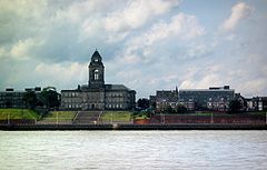
Wallasey Town Hall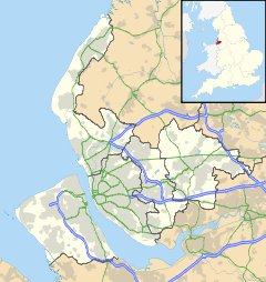
 Wallasey
Wallasey shown within MerseysidePopulation 58,710
(2001 Census)[1]OS grid reference SJ293923 Metropolitan borough Wirral Metropolitan county Merseyside Region North West Country England Sovereign state United Kingdom Post town WALLASEY Postcode district CH44 Dialling code 0151 Police Merseyside Fire Merseyside Ambulance North West EU Parliament North West England UK Parliament Wallasey List of places: UK • England • Merseyside Wallasey is a town within the Metropolitan Borough of Wirral, in Merseyside, England, on the mouth of the River Mersey, at the northeastern corner of the Wirral Peninsula. According to the 2001 Census, the town had a total resident population of 58,710.[1]
Contents
History
Toponymy
The name of Wallasey originates from the Germanic word Walha, meaning stranger or foreigner, which is also the origin of the name Wales. The suffix “-ey” denotes an island or area of dry land. Originally the higher ground now occupied by Wallasey was separated from the rest of Wirral by the creek known as Wallasey Pool (which later became the docks), the marshy areas of Bidston Moss and Leasowe, and sand dunes along the coast.
Early history
Historically part of Cheshire until 1974, the area was sparsely populated before the 19th century. Horse races organised for the Earls of Derby on the sands at Leasowe in the 16th and 17th centuries are regarded as forerunners of the modern Derby.[2]
Old maps show that the main centre and parish church (St Hilary’s) were located at what is now called Wallasey Village, and there were smaller hamlets at Liscard, Poulton and Seacombe, from where there were occasional ferries across the Mersey. There was also a mill (at Mill Lane), and from the mid-18th century a gunpowder store or magazine at Rock Point, located well away from the built-up areas.
 St. Hilary's Church
The main activities in the area were farming and fishing. The area also had a reputation for smuggling and “wrecking”,[3] the act of luring ships onto rocks or sandbanks with false lights in order to raid their cargo. Underground cellars and tunnels, which were used to hide cargo pilfered from wrecked ships still exist in the town.[4] As late as 1839, the “Pennsylvania” and two other ships were wrecked off Leasowe in a severe storm, and their cargoes and furnishings were later found distributed among local residents.[5]
Early 19th century development
By the early 19th century, the shoreline between Seacombe and Rock Point started to become an attractive area to which affluent Liverpool merchants and sea captains could retire. Development at Egremont began around this time, and gained pace with the introduction of steam ferries across the river. The area also had a defensive role overlooking the growing Port of Liverpool. In 1829, Fort Perch Rock was built, and in 1858 Liscard Battery.
In 1830, the merchant James Atherton purchased much of the land at Rock Point, which enjoyed views out to sea and across the Mersey and had a good beach. His aim was to develop it as a desirable residential and watering place for the gentry, in a similar way to one of the most elegant seaside resorts of that Regency period – hence "New Brighton". Substantial development began soon afterwards, and housing began to spread up the hillside overlooking the estuary - the gunpowder magazine being closed down in 1851.
In 1835 Liscard Hall was built by another merchant, Sir John Tobin. Its grounds later became Central Park. His family also developed a “model farm” nearby.
With the expansion of trade on the Mersey, new docks were constructed between 1842 and 1847 in the Wallasey Pool, and by 1877 the dock system between Wallasey and neighbouring Birkenhead was largely complete. The area around the docks became a centre for engineering industries, many associated with shipbuilding, and other activities including sugar refining and the manufacture of cement and fertilisers. Bidston Dock, the last in the area, was opened in 1933, but was filled in during 2003.[6]
Later growth and the 20th century
During the latter half of the 19th century New Brighton developed as a very popular seaside resort serving Liverpool and the Lancashire industrial towns, and many of the large houses were converted to inexpensive hotels. A pier was opened in the 1860s, and the promenade from Seacombe to New Brighton was built in the 1890s. This served both as a recreational amenity in its own right, and to link up the developments along the estuary, and was later extended westwards towards Leasowe. The New Brighton Tower, the tallest in the country, was opened in 1900 but closed in 1919 and dismantled shortly afterwards. However, its ballroom continued as a major venue, hosting numerous concerts in the 1950s and 1960s by local Liverpool bands as well as other international stars.
After 1886, with the opening of the Mersey Railway allowing access via a tunnel to Liverpool, the pace of housing development increased, particularly in the Liscard and Wallasey Village areas. The area now called Wallasey comprises several distinct districts which gradually merged together to form a single built-up area during the 19th and early 20th centuries. Further growth continued well into the 20th century and eventually spread into the Leasowe area and beyond to Moreton.
The UK's first guide dog training school, the Guide Dogs for the Blind Association, was founded in the town in 1931. The Wallasey Golf Club is where club member, Dr Frank Stableford, developed the Stableford system of points scoring. This was first used in competition in 1932.[7]
Because of its docks and proximity to Liverpool, parts of the area suffered aerial bombing in 1940-41. After the Second World War, the popularity of New Brighton as a seaside resort declined dramatically, as did the use of the docks, and Wallasey gradually became more obviously a residential suburb for Liverpool, Birkenhead and the other towns in the area.
The Beatles played some of their first shows outside Liverpool at the Grosvenor Ballroom in Liscard in 1960, and over the next few years also played several times at the Tower Ballroom in New Brighton. On 12 October 1962, they played there as the support act for Little Richard. Wallasey was also the home base of another leading Merseybeat group, the Undertakers featuring Jackie Lomax.
The world's first passenger hovercraft service operated in 1961-62 between Leasowe and Rhyl in North Wales. Local MP Ernest Marples was responsible as Minister of Transport (1959–64) for introducing parking meters, yellow lines and seat belt controls to the UK.
The "Solar Campus" on Leasowe Road was the first building in the world to be heated entirely by solar energy. It was formerly St George’s Secondary School, and was built in 1961 to the designs of Emslie Morgan. The solar panels on this establishment have since been removed due to high costs and has been renamed.
Civic history
Wallasey became a County Borough in 1913, and its town hall opened in 1916. The borough boundaries expanded to include Moreton and Saughall Massie in 1928.
The County Borough of Wallasey was incorporated into the Metropolitan Borough of Wirral on 1 April 1974. The town is contained in the parliamentary constituency of Wallasey, which has been held since the 1992 general election by Angela Eagle of the Labour Party.
Education
When compared to the national average, the schools of Wallasey slightly underperform on GCSE results. However they are above the national average on A Level results.
Primary schools
- Liscard Primary School
- St. George's Primary School
- Somerville Primary School
- Riverside Primary School
- Egremont Primary School
- Mount Primary School
- Park Primary School
- New Brighton Primary School
- Greenleas Primary School
- Kingsway Primary School
- St Josephs Primary School
- St. Albans Primary School
Secondary schools
- The Mosslands School
- Weatherhead High School
- The Oldershaw School
- Wallasey School
Voluntary aided schools
- St. Alban's Catholic Primary School
- St. Joseph's Catholic Primary School
- Saints Peter and Paul Catholic Primary School
- St Mary's Catholic College
Geography
The area now called Wallasey comprises several distinct districts - Egremont, Liscard, New Brighton, Poulton, Seacombe and Wallasey Village. These gradually merged together to form a single built-up area during the 19th and early 20th centuries.
Unlike in most other towns, there is no single Wallasey town centre, although the main shopping area is centrally located at Liscard. Both the parliamentary constituency and the former County Borough of Wallasey also include (or included) Leasowe, Moreton and Saughall Massie, which are now usually regarded as separate settlements.
Liscard
Main article: LiscardThis contains the main shopping area, with the covered Cherry Tree precinct and an extensive shopping parade outside. Central Park, originally the grounds of Liscard Hall, is the largest park in the town. Much of the area is residential and contains mainly high-density semi-detached housing with some terraces. The gatehouse of the old Liscard Battery remains.
Liscard Hall was destroyed by a fire on 7 July 2008. The damage was so severe, the whole building had to be demolished.[8][9]
Wallasey Village
Main article: Wallasey VillageWallasey Village has a mixture of popular mostly 20th century semi-detached and detached housing, a shopping street, with a floral roundabout in the centre. It is considered the most wealthy area of Wallasey. St Hilary’s Church is an ancient foundation; the old tower is all that remains of a 1530 church building which burned down in 1857. There are two railway stations, Wallasey Village and Wallasey Grove Road. At the north end of Wallasey Village, the main street leads to the promenade and coastal park, and two golf courses. The promenade passes here, running from the 'Gunsite' around to Seacombe, a total of over 7 miles.
New Brighton
 New Brighton Lighthouse on Perch Rock.Main article: New Brighton, Merseyside
New Brighton was a popular seaside resort after the mid-19th century, but declined in popularity after the 1950s. Nevertheless, the marine promenade is part of a popular walk and the areas near the sea offer a much improved beach and many leisure activities. The Floral Pavilion plays host to regular productions and national stars such as Ken Dodd, and Vale Park is a beautiful public park. Housing here ranges from large villas near the sea to suburban semi-detached homes, while there are some less attractive terraces in parts of the area. New Brighton is served by a railway station of the same name. New Brighton promenade is the UK's longest promenade.[citation needed]
Poulton
Main article: Poulton, MerseysidePoulton was originally a small fishing and farming hamlet beside the Wallasey Pool (hence its name). It developed with the growth of the docks, mainly as an industrial and terraced housing area.
Egremont
Main article: Egremont, MerseysideEgremont developed as an affluent residential area in the early 19th century, and was named by one Captain Askew who built a house in the area in 1835 and named it after his Cumberland birthplace. Egremont Pier was built in 1827 and was the longest pier on Merseyside until it was damaged irreparably in 1946 when a coaster collided with it. Wallasey Town Hall, an imposing edifice opened in 1916 and initially used as a war hospital, is located here, overlooking the estuary and with its back to the town. This area is now almost entirely housing, although there is a small shopping area on King Street.
Seacombe
Main article: SeacombeSeacombe, the most southeasterly section of Wallasey, is best known for its Mersey Ferry terminal, with regular ferry boat departures to Pier Head in Liverpool and Woodside in Birkenhead. There is a commuter ferry service direct to Liverpool during peak hours, while for the rest of the day the ferries are geared to serving tourists with a circular cruise visiting Birkenhead Woodside ferry terminal as well. Seacombe is the last remaining of the three ferry terminals which used to connect the Borough of Wallasey, the others being Egremont Ferry and the New Brighton Ferry, which operated from its own pier, running parallel to the New Brighton pleasure pier. Seacombe Ferry is also the starting point of a four mile unbroken promenade, mostly traffic-free, running alongside the River Mersey to Harrison Drive beyond New Brighton.
Local landmarks are St Paul's Church, standing on its own traffic island, and the ventilation tower for the Kingsway Tunnel with its mighty extraction fans. As with Poulton, the area developed with housing for the dockworkers and nearby industries, and much of the housing is owned by Wirral Partnership Homes or are terraced. The Guinea Gap swimming baths are located between Seacombe and Egremont.
Transport
Road
- The Kingsway Tunnel, Opened by Queen Elizabeth II when it was completed in 1971, its roadway route via Poulton leads to its entrance in Seacombe, which links Wallasey with the centre of Liverpool and is set to be featured in Harry Potter and the Deathly Hallows Part 1
- The M53 motorway begins in Poulton and leads south through the centre of the Wirral Peninsula to Chester and the M56 motorway continues to Manchester Airport.
- The North Wallasey Approach Road begins in Wallasey Village and ends in Bidston at Junction 1 of the M53.
- Leasowe Road gives access to Leasowe and Moreton to the west, and to Wallasey Village to the east.
Rail
Present
There are three railway stations: Wallasey Village, Wallasey Grove Road and New Brighton. Electric trains to Liverpool and Birkenhead depart every 15 minutes (every 30 minutes during late evenings and on Sundays). Grove Road station has a large car park with over 160 spaces. There are also railway stations located in Leasowe and Moreton on the railway to West Kirby.
Past
Formerly, an additional railway line ran from Seacombe (& Egremont) station to Wrexham. An intermediate station served Liscard & Poulton. The line, and both stations, closed to passengers in 1960 when the trains were diverted to New Brighton. Subsequently these trains were diverted away from Wallasey to start from Birkenhead North and nowadays from Bidston. The cutting where the line once ran now forms the approach road to the Kingsway Tunnel, and Seacombe station site was developed for housing.
Bus
Regular bus services (Arriva routes 432 and 433) depart Liscard every 10 minutes and travel via the Kingsway Tunnel to Liverpool. In addition, there are several services which link the districts of Wallasey and nearby towns such as Birkenhead, Leasowe and Moreton.
Until 1969, Wallasey had its own corporation bus service; from this date the operation was taken over by Merseyside Passenger Transport Executive. The Wallasey bus service was relatively constrained within the borough boundaries, and had two distinctive features. One was the unusual livery, which appeared to be two shades of yellow (officially it was "sea green" and rich cream, but it always looked yellow and the service was generally known as the "yellow buses"). Secondly the services mostly radiated from Seacombe Ferry terminal across the borough, and bus departures coincided with the arrival of the ferry. Vehicles were lined up facing outwards from the kerb and every 10–15 minutes the passengers (several hundreds at peak hours) would arrive from the ferry boat. When all had boarded their respective routes the inspector in charge would blow a whistle and there would be an amazing Le Mans-style start with up to fifteen double-decker buses, including racing engines, close manoeuvring, and competitive gestures between the crews, for the first few hundred yards until the routes gradually diverged across the borough.
Notable people
The following people were born in Wallasey:
- Samuel John "Lamorna" Birch (1869–1955), painter
- Olaf Stapledon (1886–1950), science fiction writer and philosopher
- Walter McLennan Citrine, Baron Citrine, GBE, PC (1887–1983), trade unionist and politician
- Saunders Lewis (1893–1985), Welsh nationalist politician and writer
- Major Bill Tilman, CBE, DSO, MC and Bar (1898–1977), mountaineer and explorer
- Sidonie Goossens (1899–2004), harpist
- Frank Doel (1908–1968), bookseller in London, whose story is told in 84 Charing Cross Road
- Malcolm Lowry (1909–1957), writer (Under the Volcano)
- Charles Crichton (1910–1999), film director (The Lavender Hill Mob, A Fish Called Wanda)
- Leslie Graham (1911-1953), world champion motorcycle racer
- Deryck Guyler (1914–1999), actor and comedian
- Raymond Moore, (1920–1987), photographer
- Graham Stark (b 1922), actor
- Dickie Davies (b 1933), TV sports journalist and presenter
- Rita Hunter CBE (1933–2001), opera singer
- Ralph Steadman (b 1936), artist and cartoonist
- Ann Bell (b 1940), actress
- Geoffrey Hughes (b 1944), actor
- Michael Carson (b 1946), writer
- Nigel Olsson (b 1949), rock drummer (Elton John)
- Alan Rouse (1951–1986), mountaineer
- Ray Stubbs (b 1956), TV sports presenter
- Louise Delamere (b 1969), actress
- Dominic Purcell, (b 1970), actor
- Elizabeth Berrington, (b 1970), actress
- Austin Healey (b 1973), Leicester and England Rugby Union player
- Jenny Frost, (b 1978), singer (member of Atomic Kitten)
- Jay Spearing (b 1988), Liverpool F.C. defender and defensive midfielder
Eric Idle, of Monty Python fame, lived in Wallasey between the ages of three and nine (1946–1952). Other former residents include Matthew Smith, games programmer who developed several well-known titles for the Sinclair ZX Spectrum in the 1980s; and Simon "Sice" Rowbottom (b 1969) and Timothy Brown from the band the Boo Radleys. England International darts player Robbie "Kong" Green lives in the town.
References
- ^ a b (pdf) 2001 Census: Wallasey, Office for National Statistics, http://www.statistics.gov.uk/downloads/census2001/ks_ua_ew_part1.pdf, retrieved 14 March 2007
- ^ Horse racing, VisitLiverpool.com, http://www.visitliverpool.com/site/welcome-to-liverpool/sport-in-liverpool/horse-racing, retrieved 2 August 2009
- ^ Northwest England, Smugglers' Britain, http://www.smuggling.co.uk/gazetteer_wales_14.html, retrieved 2 August 2009
- ^ Wirral Smugglers, Wreckers and Pirates by Gavin Chappell (Countyvise 2009) ISBN 978-1-906823-20-7
- ^ Kemble, Mike, The Wallasey Wreckers and the USS Pennsylvania, http://www.mikekemble.com/mside/wallasey1.html, retrieved 2 August 2009
- ^ Birkenhead Docks (photo18), Merseyside Views, http://www.merseysideviews.com/Merseyside%20Docks/Birkenhead/pages/Bir%20Dks%20018.html, retrieved 3 February 2009
- ^ "Dr Frank Stableford". Wallasey Golf Club. http://www.wallaseygolfclub.com/stableford.html. Retrieved 2009-07-21.
- ^ Fire wrecks listed house, Liverpool Echo, 7 July 2008, http://www.liverpoolecho.co.uk/liverpool-news/local-news/2008/07/07/fire-wrecks-listed-house-100252-21275005/, retrieved 17 July 2008
- ^ Liscard Hall, http://www.liberator31.co.uk/wallasey/liscard_hall/index.html, retrieved 17 July 2008
External links
Ceremonial county of Merseyside Metropolitan districts Major settlements Rivers Topics Categories:- Towns and villages in Wirral (borough)
- Towns in Merseyside
- Merseyside


Wikimedia Foundation. 2010.